The line first opened in 1878 as a two-track surface-level excursion railroad called the Brooklyn, Flatbush and Coney Island Railway, transporting riders from Downtown Brooklyn via a connection with the Long Island Rail Road (LIRR) to the seaside resorts at Coney Island. When its connection with the LIRR was severed in 1883, the line became the Brooklyn and Brighton Beach Railroad, which was eventually acquired by the Brooklyn Rapid Transit Company (BRT, later Brooklyn–Manhattan Transit Corporation [BMT]). From 1903 to 1908, all of the original line's grade crossings were eliminated; This project also widened the line from two to four tracks from Church Avenue to Sheepshead Bay; From 1918 to 1920 the portion of original open-cut right-of-way from Church Avenue to Prospect Park station was widened to four tracks and a new subway alignment was built north of the Prospect Park station. The northern part of the original line became the modern-day BMT Franklin Avenue Line, which still runs today. In subsequent years, numerous improvements were made to the Brighton Line.
History
Origins
Route designation on BMT Triplex equipment
The Brighton Line opened from the Willink Plaza entrance of Prospect Park (modern intersection of Flatbush and Ocean Avenues and Empire Boulevard, now the Prospect Park station on both the renamed Brighton and the Franklin Avenue Shuttle lines) to Brighton Beach (modern Coney Island Avenue at the shoreline) on July 2, 1878, and the full original line on August 18. It was an excursion railroad — the Brooklyn, Flatbush and Coney Island Railway — to bring beachgoers from downtown Brooklyn (via a connection with the Long Island Rail Road) to the seashore at Coney Island on the Atlantic Ocean, at a location named Brighton Beach at the same time the railroad arrived. It has been known since its opening as the Brighton Beach Line but is now described as the Brighton Line in MTA literature and in public usage.
After losing its connection with the Long Island Rail Road in 1883, the railroad fell on hard times, reorganizing as the Brooklyn and Brighton Beach Railroad. Seeking a new route for its excursion business and its local trade in communities along the way, it formed an agreement with the Kings County Elevated Railway to connect to its Fulton Street Line, which gave access to the new Brooklyn Bridge and Manhattan passengers. This was accomplished in 1896.
A series of mergers and leases put the Brighton Beach Line in the hands of the Brooklyn Rapid Transit Company (BRT), a holding company which eventually controlled most of the rapid transit, streetcar, and bus lines in Brooklyn and part of Queens. The line was electrified with trolley wire and, for a time, trolleys from several surface routes and elevated trains operated together on the line.
BMT Brighton Line was built next to right of way of LIRR. LIRR tracks were removed but the abutment placement still indicated where the right of way was
The original line was a two-tracked high-speed surface steam railroad operating from Bedford Station, at Atlantic Avenue near Franklin Avenue in the City of Brooklyn, at which point it made a physical connection to the Long Island Rail Road's Atlantic Branch. From Bedford the line ran on a surface private right-of-way several blocks south to Park Place, which it crossed at grade, and then in an open cut with street overpasses through what is now Crown Heights and Flatbush, as far as Church Lane (now Church Avenue) in the Town and Village of Flatbush. From that point the line continued on the surface to a point at current Beverley Road between Marlborough Road (East 15th Street) and East 16th Street, curving southeast and running on the surface between the lines of the latter streets through the Towns of Flatbush and Gravesend to Sheepshead Bay, then turning southerly to reach the beach at Brighton Beach on Coney Island in the Town of Gravesend.
The line was extended westward from Brighton Beach in 1903, so that it could terminate with the former Prospect Park and Coney Island Railroad at Culver Depot in Coney Island. Passengers, with this short extension, were given access to the developing area of Coney Island. The Culver Depot became the center of operations for the Culver Line and the Brighton Beach Line.[3]
Grade crossing eliminations, 1903–1908 and 1918–1920
In 1903, the New York State Legislature created the Brooklyn Grade Crossing Elimination Commission (BGCEC) to eliminate all grade crossings on the Brighton Beach Line and the Bay Ridge Line of the Long Island Rail Road. The city was supposed to cover half of the costs, not exceeding $1 million, while the railroads were to cover the other half of the costs. The work started on December 30, 1905, and was completed in 1908. A short piece of two-tracked elevated railroad was built from the ramp connecting to the Fulton Street Elevated as far as Park Place, where the original 1878 open cut began. From the end of that original cut south of Church Avenue, the line was wholly rebuilt as a four-track railroad with express and local stations to a point south of Neptune Avenue at the border of Coney Island, continuing along its original right-of-way to Brighton Beach station. The portion from Church Avenue to Avenue H was placed in a depressed open cut, while the portion from Avenue H to south of Sheepshead Bay was raised onto an earthen embankment, primarily with earth excavated from the open-cut portion and from the Bay Ridge Improvement of the Long Island Rail Road. The separation of the railroad grade allowed the line's trolley wire north of Sheepshead Bay to be replaced with ground-level third rail.[3]
The work by the BGCEC left the line between Park Place and Church Avenue in substantially its original condition from steam railroad days. Between 1918 and 1920, however, further work rebuilt the portion between Prospect Park and Church Avenue as a four-track line. At the same time, the remaining portion of the line south of Neptune Avenue was replaced with a four-track elevated structure, including a four- to six-track elevated line extension, connecting the Brighton Line to the new Coney Island terminal at Surf and Stillwell Avenues. This same work rerouted mainline Brighton Beach trains from the Fulton Street elevated line via a new deep tunnel under Flatbush Avenue to connect to the BMT Fourth Avenue Line at DeKalb Avenue station, where trains could access the new BMT Broadway subway. This work was done as a part of the Dual Contracts.
A spur south of Neck Road, which split to Sheepshead Bay Race Track, was in use from 1909 to around 1929. The single-track spur was part of the Long Island Rail Road's Manhattan Beach Branch, and it ran at street level to Ocean Avenue between Avenues X and Y, where it terminated at a six-track terminal.[4]:2
Brighton–Franklin Line
The St. Felix Street and Flatbush Avenue Connection opened on August 1, 1920, providing direct service between the Brighton Line and midtown Manhattan.[2][5] With the opening of the connection, the original portion of the line between the Fulton Street Elevated and the link to the new subway at Prospect Park became a secondary line, known as Brighton–Franklin, and now known as the BMT Franklin Avenue Line. At times through services (including expresses) operated on mainline Brighton tracks to Coney Island. Some special weekend trains even operated beyond Coney Island back to Manhattan via the BMT Sea Beach Line express tracks and the BMT Fourth Avenue Subway. This service was variously known as Franklin–Nassau and as the Coney Island Express, but its popular name was the "Sunny Sunday Summer Special," because it was only supposed to operate as needed on the hottest beach-going days.
In Fiscal Year 1930, an additional control area with staircases to the platforms at Kings Highway were constructed, and additional stairs were added at Avenue M, Avenue U, and Avenue J.[6]
Through services gradually diminished on the Brighton–Franklin, and after 1963 it became a pure shuttle, operating between Franklin Avenue station at Fulton Street and Prospect Park station, where it connects with mainline Brighton Beach trains.
During the era of route contraction from 1940 to about 1975, the Franklin Avenue Shuttle seemed a prime candidate for abandonment; its physical structure had been allowed to deteriorate and its service steadily curtailed. The New York City fiscal crisis of the '70s and the recession in 1990 contributed to plans to discontinue the line. By the 1990s the Franklin Avenue Shuttle was known as the "ghost train". It was shrunk in size to only two cars and the Dean Street station was closed. The entire line was under consideration for abandonment, but community pressure forced the MTA to rebuild rather than abandon the line, and as a result, most of the supporting infrastructure and stations were completely rehabilitated in 1998–1999 at a cost of $74 million and reopened in 1999.[7]
Platform extensions, track repairs, and Stillwell Avenue reconstruction
On June 16, 1964, Mayor Robert F. Wagner Jr. approved the award of a $2,283,933 contract for the second phase of work to extend platforms along the Brighton Line. The platforms were to be lengthened to 615 feet (187m) feet to accommodate a ten-car train of 60-foot (18m) long IND cars, or a nine-car train of 67-foot (20m) long BMT cars, instead of the existing 8-cars. The contract for the first phase of work had been let the previous year for the seven stations between Atlantic Avenue and Newkirk Avenue. The platform extensions at these stations were completed during the 1964–1965 fiscal year. The contract for the second phase called for the extension of platforms at the ten remaining stations on the line from Avenue H to Stillwell Avenue. Work on the second contract was still ongoing in 1965.[8][9]
Between April 26, 1986, and October 26, 1986, service was disrupted due to track repairs and other construction work along the line. The two local tracks were completely rebuilt between Prospect Park and Newkirk Avenue, in two phases, with the Manhattan-bound track rebuilt first between April and July, and the Brooklyn-bound track rebuilt between July and October. A temporary platform was built at Cortelyou Road while Beverley Road and Parkside Avenue were closed in one direction because temporary platforms could not be built at these locations.[10] To reduce congestion, skip-stop service was implemented on weekdays, which lasted until 1988.[11]
From September 8, 2002, to May 23, 2004, service was suspended west of Brighton Beach due to allow rebuilding of the Coney Island–Stillwell Avenue terminal station, which had deteriorated due to the effects of salt water corrosion and deferred maintenance.[12]
Brighton Line Station Reconstruction Project
The platform at Avenue U during reconstruction.Track work at Newkirk Plaza in September 2011 marking the end of the station reconstruction project.Replacing of tracks on the BMT Brighton Line
In 2007, the MTA announced that it would reconstruct seven stations between Newkirk Avenue and Neck Road, inclusive.[13] On December 8, 2008, the first phase of the Brighton Line Station Reconstruction Project began. The Coney Island-bound platforms at Avenue U and Neck Road were closed for rebuilding and all southbound trains ran on the express track from Kings Highway to Sheepshead Bay.[14]
On September 14, 2009, the second phase of the project involving all stations from Newkirk Plaza to Kings Highway began. Express B train service was suspended and all trains ran local in both directions for the next two years.[15] Over the next two weeks, temporary platforms were placed on the Manhattan-bound express track at Kings Highway and Avenue J for southbound service. On September 28, the southbound platforms of Avenue H, Avenue J, Avenue M, and Kings Highway began rebuilding. South of Cortelyou Road, a single crossover connected the southbound local track with the express one and all southbound trains skipped Avenue H and Avenue M.
On January 18, 2010, Coney Island-bound service was restored at Avenue U and Neck Road. The Manhattan-bound platforms were closed for rebuilding until October 25 and all northbound trains operated on the express track from Sheepshead Bay to Kings Highway.
On September 13, Coney Island-bound service to Avenue H and Avenue M was restored and the two southbound tracks south of Cortelyou Road were separated. Over the next two weeks, the temporary platforms at Avenue J and Kings Highway were moved to the southbound express track and the two northbound tracks were connected to each other north of Newkirk Plaza. On September 27, the Manhattan-bound platforms of those three stations as well as Avenues H and M, which were then being bypassed, began rehabilitation and all northbound service was directed to the express track until Cortelyou Road. The platforms of all stations reopened on September 12, 2011, and B express service was restored on October 3. However, rehabilitation work that did not affect service continued until the end of the year.
As part of the project, station platforms were replaced and widened, windscreens and canopies were replaced, station lighting was upgraded, new public address systems were installed, and new station agent booths were put into place. In addition, ADA-compliant elevators were installed at Kings Highway, the historic station house at Avenue H was restored, an additional southbound entrance was installed at Avenue H, and additional fare entrances were created to the northbound platform sections of the Avenue M and Avenue J stations.[16]
Service patterns
The following services use part or all of the Brighton Line:[17]
Since 1920, the primary service on the line has been through to Manhattan rather than over the tracks now used by the Franklin Avenue Shuttle. Local service has run all the time, while express service has generally been provided during weekday rush hours and later middays. Until the 1960s, all service on the line north of Prospect Park was labeled 1.
Standard local service ran through the Montague Street Tunnel and along the BMT Broadway Line local tracks; service instead crossed the Manhattan Bridge north tracks and ran express under Broadway during Broadway theatre hours (7:30 pm to midnight). Over the years, the local bridge service was expanded, and the local tunnel service ended up only from 6 am to 7 pm. Express service over the bridge to the Broadway express tracks, initially during rush hours, was also expanded to 6 am to 7 pm. The three patterns were assigned latter designations in the early 1960s: Q express via bridge, QT local via tunnel, and QB local via bridge.
The Chrystie Street Connection opened in late 1967, and almost all Brighton Line trains were removed from Broadway. The Q and QB were both combined with the D on the IND Sixth Avenue Line, running express during the day and local at other times. The daytime QT local was combined with the Jamaica local and express (then #15) to form the QJ, running through the tunnel to the BMT Nassau Street Line, which also replaced the limited rush hour Brighton “Bankers’ Specials” to Nassau Street. The only Brighton-Broadway service was a new QB, with a limited number of runs in the peak direction at rush hours on the local Brighton and express Broadway tracks. There were also a limited number of NX trains from Brighton Beach via Coney Island and the Sea Beach express tracks, then up Broadway, a short-lived service that also attempted to compensate for the elimination of major Brighton/Broadway service. (The two QB services were distinct; the old QB had run at non-peak times; this new QB had the same name and almost the same route but was a different service.)
The QJ's Brighton section was replaced with an extension of the M in 1973. In 1985, the QB was renamed Q as the subway eliminated the double letter naming system for local routes.[18] Reconstruction of the Manhattan Bridge subway tracks began, which would continue until 2004. Though the same general service patterns remained on the Brighton Line, all trains were sent over the bridge and onto the Broadway or Sixth Avenue Line, depending on which set of tracks was open. From 1986 to 1988, the south side (Broadway) was in service, and the D continued to serve the line at all times, the M was rerouted onto the BMT Fourth Avenue Line and Q service now also ran during middays. Because of the concurrent track and infrastructure repairs on the Brighton Line, express service was suspended for two years. As tracks between Prospect Park and Newkirk Avenue were rebuilt, the D and Q provided skip-stop service between Newkirk Avenue and Sheepshead Bay on weekdays. D trains served Neck Road, Avenue M and Avenue H; the Q skipped those stops, serving Avenue U and Avenue J, while both trains served Kings Highway.[11] By 1987, as the line's reconstruction progressed, the weekday skip-stop pattern expanded to Prospect Park, with D trains serving Beverley Road while Q trains served Cortelyou Road and Parkside Avenue, with Church Avenue as a mutual station.[19]
On December 11, 1988, the Bridge's north (Sixth Avenue) tracks reopened; at this time, the skip-stop pattern was eliminated, and the D became a full-time local service to Stillwell Avenue, while the Q ran express on weekdays to Brighton Beach. Both trains ran via Sixth Avenue Express. From April 30 to November 12, 1995, the Manhattan Bridge fully closed during middays and weekends. D service in Brooklyn was suspended during these hours; the Q replaced it, running local to Stillwell Avenue and via the Montague Street Tunnel and Broadway Express.[20][21]
The 2001 shifting of trains back to the south side (Broadway) led to the D only running north of Midtown Manhattan; the Q replaced the D as the full-time Brighton Local while the Brighton express portion of the Q became the diamond <Q>. When both sides of the bridge reopened in 2004, the <Q> was discontinued and replaced by the B in Brooklyn. The B was restored to the Brighton Line rather than the West End Line, where it had run from 1967 to 2001, to combine two weekday-only services and because Brighton Line residents preferred Broadway Service, the Q was kept as the full-time local. In effect, this flipped the B and D services, as the D was transferred to the West End Line following the bridge's reopening.[22]
Description
A double crossover linking both express tracks located between Prospect Park and Church Avenue.
The modern-day line shows a mix of its various re-buildings.
At Prospect Park, the Brighton subway tunnel emerges into an open cut. The Prospect Park station contains a cross-platform interchange with the BMT Franklin Avenue Line, which is used by the Strain. Franklin Avenue Line trains use the northbound local track, while the express tracks in both directions are used by the Brighton Line trains; the southbound local track is not in service.[23] The former alignment of the Brighton Line ran along what is now the Franklin Avenue Line, which had been built as a surface railway in 1878 and rebuilt as a grade-separated open-cut and embankment line in 1905.
Prospect Park to Brighton Beach
South of Prospect Park, the Brighton Line widens to a four-track line for much of the rest of the route. The B continues on the inner tracks and runs to Brighton Beach, serving only express stations, while the Q splits to the outer tracks, serving all stops until the end of the line at Coney Island–Stillwell Avenue. The original line built in 1878 ran in a two-track open cut. This segment was rebuilt in 1918 to 1920 to a four track line with an express station at Prospect Park, a local station at Parkside Avenue (replacing the original station at Woodruff Avenue) and another express station at Church Avenue. The line features slightly sloped and capped reinforced concrete walls, as well as cut-and-cover tunnels underneath cross-streets.
The segment between Church Avenue to Avenue H is a result of the BGCEC rebuilding program of 1903–1907. Just south of the tunnel under Church Avenue, the construction of the cut wall visibly changes. Steel trestles carry the streets above the line, giving it a more open appearance. Cottage-style station houses are suspended over the line at local stations at Beverley and Cortelyou Roads, and at the express station at Newkirk Plaza. Past Newkirk Plaza the line continues in an open cut, then begins to rise to street level at the north end of Avenue H station.[23]
Sheepshead Bay station, looking northward across the express tracks
The line continues south on the 1907 embankment to a bridge over Neptune Avenue. At this point the BGCEC roadbed ends. Prior to the Dual Contracts rebuild in the late 1910s, the line descended to the surface on two single track concrete and steel ramps to operate on the surface to Brighton Beach. As part of the 1918–1920 Dual Contracts work, all four tracks now continue on a steel elevated structure to the junction of Coney Island and Brighton Beach Avenues, where the line turns west onto Brighton Beach Avenue and enters the Brighton Beach station.
Brighton Beach to Coney Island
Bilevel elevated section, from West 8th Street to Stillwell Avenue-Coney Island station. Its lower level is used by IND Culver Line
Traveling west from Brighton Beach station, the line operates on a six track elevated structure over Brighton Beach Avenue. One track splits from each pair of local and express tracks in each direction. Only the outer two tracks are currently used for revenue service, carrying Q trains. The inner four are layup tracks used to store B trains that terminate at Brighton Beach; the innermost two tracks are the former right-of-way of the Sea View Railway, which originally provided service west of Brighton Beach.[23]
Crossing West 5th Street
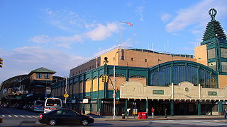
Each of the two layup tracks between the local and express tracks ends before Ocean Parkway station, while the innermost and outermost tracks stop at the station. The outer tracks merge with the inner tracks, and the inner tracks climb to an upper level. The outer trackways remain at the same elevation, and shortly afterward merge with the two tracks of the IND Culver Line (Fand<F>trains), which merge into the structure from the north. Both lines then stop at the West Eighth Street–New York Aquarium station, a double-level steel structure with two tracks on each level. The Brighton trains occupy the upper level and the Culver Line trains the lower.[23] Both lines then enter the 8-track Stillwell Avenue terminal, which was built in 1917–1920 and renovated in 2001–2004. The Brighton trains occupy tracks 3 and 4.[23]
6 tracks; only four outer tracks stop at this station. Within station, outermost tracks are used by trains using the bridge, and center tracks are used by trains using the tunnel. Innermost tracks are used by BMT Fourth Avenue Line express trains from the bridge.
The Q Second Avenue/Broadway Express/Brighton Local is a rapid transit service in the B Division of the New York City Subway. Its route emblem, or "bullet", is colored yellow since it is a part of the BMT Broadway Line in Manhattan.
The BMT West End Line is a line of the New York City Subway, serving the Brooklyn communities of Sunset Park, Borough Park, New Utrecht, Bensonhurst, Bath Beach and Coney Island. The D train operates local on the entire line at all times. Although there is a center express track and three express stations along the line, there is no regular express service.
The B Sixth Avenue Express is a rapid transit service in the B Division of the New York City Subway. Its route emblem, or "bullet", is colored orange, since it uses the IND Sixth Avenue Line in Manhattan.
The Chrystie Street Connection is a set of New York City Subway tunnels running the length of Chrystie Street on the Lower East Side of Manhattan. It is one of the few track connections between lines of the former Brooklyn–Manhattan Transit Corporation (BMT) and Independent Subway System (IND) divisions, which together constitute the system's B Division. A major branch of the IND Sixth Avenue Line, it connects the Sixth Avenue Line to the BMT Brighton Line and BMT Fourth Avenue Line via the north side of the Manhattan Bridge and to the BMT Jamaica Line over the Williamsburg Bridge. The project, opened in 1967 and 1968, also includes the Sixth Avenue Line's Grand Street and 57th Street stations, the latter of which is not part of the connection itself.
The Brighton Beach station is an elevated express and terminal station on the BMT Brighton Line of the New York City Subway. It is located over Brighton Beach Avenue between Brighton 5th Street and Brighton 7th Street in Brighton Beach, Brooklyn. The station is served by the Q train at all times and is the southern terminal for the B train on weekdays only.
The Ocean Parkway station is an express station on the New York City Subway's BMT Brighton Line. It is located at Brighton Beach Avenue and Ocean Parkway in Brighton Beach, Brooklyn. The station is served by the Q train at all times.
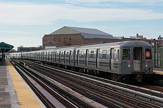
The Coney Island–Stillwell Avenue station is a New York City Subway terminal in Coney Island, Brooklyn. It is the railroad-south terminus for the D, F, N, and Q trains at all times and for the <F> train during rush hours in the peak direction.
The D Sixth Avenue Express is a rapid transit service in the B Division of the New York City Subway. Its route emblem, or "bullet", is colored orange, since it uses the IND Sixth Avenue Line in Manhattan.
The N Broadway Express is a rapid transit service in the B Division of the New York City Subway. Its route emblem, or "bullet," is colored yellow, since it uses the BMT Broadway Line in Manhattan.
The BMT Sea Beach Line is a rapid transit line of the BMT division of the New York City Subway, connecting the BMT Fourth Avenue Line at 59th Street via a four-track wide open cut to Coney Island in Brooklyn. It has at times hosted the fastest express service between Manhattan and Coney Island, since there are no express stations along the entire stretch, but now carries only local trains on the N service, which serves the entire line at all times. During rush hours, several W trains serve the line north of 86th Street.
The Prospect Park station is an express station on the BMT Brighton Line of the New York City Subway. It is located in between Lincoln Road, Lefferts Avenue, Empire Boulevard, Ocean Avenue and Flatbush Avenue in Flatbush, Brooklyn, near the border of Crown Heights, Prospect Heights, Park Slope, and Prospect Lefferts Gardens. The station, which serves Prospect Park and Brooklyn Botanic Garden, is served by the Q train and Franklin Avenue Shuttle at all times and by the B train on weekdays.
The Newkirk Plaza station is an express station on the BMT Brighton Line of the New York City Subway in Flatbush, Brooklyn. It is located on an open-cut at the center of the pedestrian-only Newkirk Plaza shopping mall, which is bounded by Newkirk Avenue on the north, Foster Avenue on the south, Marlborough Road to the west, and East 16th Street to the east. The station is served by the Q train at all times and by the B train on weekdays only.
The Sheepshead Bay station is an express station on the BMT Brighton Line of the New York City Subway. It is located in the Sheepshead Bay neighborhood of Brooklyn. It is served by the Q train at all times and by the B train on weekdays.
The West Eighth Street–New York Aquarium station is a New York City Subway station, located on the BMT Brighton Line and IND Culver Line in the Coney Island neighborhood of Brooklyn. The station is located over the private right-of-way of the defunct New York and Coney Island Railroad north of Surf Avenue, running easterly from West 8th Street. It is served by the F and Q trains at all times, and by the <F> train during rush hours in the peak direction. This station is geographically the southernmost station in the entire New York City Subway system.
The Avenue M station, is a local station on the BMT Brighton Line of the New York City Subway. It is located in Midwood, Brooklyn, at Avenue M between East 15th and East 16th Streets. The station is served by the Q train at all times.
The Neck Road station is a local station on the BMT Brighton Line of the New York City Subway. It is located at Gravesend Neck Road between East 15th and East 16th Streets in Homecrest, Brooklyn. The station is served by the Q train at all times.
The Avenue U station is a local station on the BMT Brighton Line of the New York City Subway, located at Avenue U between East 15th and East 16th Streets in Homecrest and Sheepshead Bay, Brooklyn. The station is served by the Q train at all times.
The Kings Highway station is an express station on the BMT Brighton Line of the New York City Subway. It is located at Kings Highway between East 15th and East 16th Streets on the border of Midwood and Sheepshead Bay neighborhoods of Brooklyn. The station is served by the Q train at all times and by the B train on weekdays only.
↑ "Brighton Line Riders Your Guide To Service Changes On The B Q M During Rehabilitation Work April 26 Through October 26, 1986" (Document). New York City Transit Authority. April 1986.
↑ "Brighton Stations Rehabilitation"(PDF). secondavenuesagas.com. Metropolitan Transportation Authority. November 2007. Archived from the original(PDF) on March 16, 2017. Retrieved April 1, 2019.
↑ "A Message from Line General Manager Jim Leopard... B Q An Overview of the Brighton Line Rehabilitation Project" (Document). New York City Transit. 2009.
Note that this is a list of New York City Subway lines, which are the physical infrastructure over which services operate. Lines with colors next to them are trunk lines; trunk lines determine the color of New York City Subway service bullets, except for shuttles, which are dark gray.
This page is based on this Wikipedia article Text is available under the CC BY-SA 4.0 license; additional terms may apply. Images, videos and audio are available under their respective licenses.