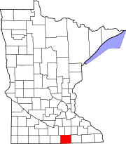
Bancroft Township, Freeborn County, Minnesota

Last updated

Bancroft Township
USA Minnesota location map.svg
Red pog.svg
Bancroft Township
Location within the state of Minnesota
Usa edcp location map.svg
Red pog.svg
Bancroft Township
Bancroft Township (the United States)
Coordinates: 43°42′46″N93°22′3″W / 43.71278°N 93.36750°W / 43.71278; -93.36750
Country United States
State Minnesota
County Freeborn
Area
  Total33.7 sq mi (87.2 km2)
  Land33.7 sq mi (87.2 km2)
  Water0.0 sq mi (0.0 km2)
Elevation
1,243 ft (379 m)
Population
 (2000)
  Total1,065
  Density31.6/sq mi (12.2/km2)
Time zone UTC-6 (Central (CST))
  Summer (DST) UTC-5 (CDT)
FIPS code 27-03466 [1]
GNIS feature ID0663501 [2]

Bancroft Township is a township in Freeborn County, Minnesota, United States. The population was 1,065 at the 2000 census.

Contents

Bancroft Township was organized in 1858, and named for George Bancroft, an American historian. [3]

Geography

According to the United States Census Bureau, the township has a total area of 33.7 square miles (87 km2), of which 33.7 square miles (87 km2) is land and 0.03% is water.

Bancroft Creek flows through the township.

Transportation

Interstate 35 crosses the eastern side of the township, leading north to Clarks Grove and south to Albert Lea. Interstate 90 crosses the southern side of the township, immediately north of Albert Lea. County Road 22 exit provides access to the township along I-90. Albert Lea Municipal Airport and Riverland College are both nearby. Other routes in the township include County Roads 14, 20, 25, 45, and 101.

Demographics

As of the census [1] of 2000, there were 1,065 people, 397 households, and 325 families residing in the township. The population density was 31.6 inhabitants per square mile (12.2/km2). There were 404 housing units at an average density of 12.0 per square mile (4.6/km2). The racial makeup of the township was 99.25% White, 0.09% African American, 0.28% Asian, 0.09% from other races, and 0.28% from two or more races. Hispanic or Latino of any race were 2.07% of the population.

There were 397 households, out of which 33.8% had children under the age of 18 living with them, 78.3% were married couples living together, 2.8% had a female householder with no husband present, and 18.1% were non-families. 15.1% of all households were made up of individuals, and 7.3% had someone living alone who was 65 years of age or older. The average household size was 2.68 and the average family size was 2.98.

In the township the population was spread out, with 25.9% under the age of 18, 4.8% from 18 to 24, 25.8% from 25 to 44, 28.9% from 45 to 64, and 14.6% who were 65 years of age or older. The median age was 41 years. For every 100 females, there were 112.2 males. For every 100 females age 18 and over, there were 105.5 males.

The median income for a household in the township was $47,102, and the median income for a family was $52,875. Males had a median income of $33,611 versus $24,904 for females. The per capita income for the township was $22,744. About 1.5% of families and 2.5% of the population were below the poverty line, including 2.2% of those under age 18 and 3.8% of those age 65 or over.

Related Research Articles

<span class="mw-page-title-main">Freeborn County, Minnesota</span> County in Minnesota, United States

Freeborn County is a county in the state of Minnesota. As of the 2020 census, the population was 30,895. Its county seat is Albert Lea. Freeborn County comprises the Albert Lea Micropolitan Statistical Area.

Burr Oak Township is a civil township of St. Joseph County in the U.S. state of Michigan. As of the 2000 census, the township population was 2,739. The Village of Burr Oak is located within the township.

Osage Township is a township in Becker County, Minnesota, United States. The population was 774 as of the 2000 census.

Albert Lea Township is a township in Freeborn County, Minnesota, United States. The population was 808 at the 2000 census.

Freeman Township is a township in Freeborn County, Minnesota, United States. The population was 528 at the 2000 census.

<span class="mw-page-title-main">Hayward, Minnesota</span> City in Minnesota, United States

Hayward is a city in Freeborn County, Minnesota, United States, near Albert Lea. The population was 250 at the 2010 census.

Pickerel Lake Township is a township in Freeborn County, Minnesota, United States. The population was 746 at the 2000 census.

Acoma Township is a township in McLeod County, Minnesota, United States. The population was 1,185 at the 2000 census.

Borgholm Township is a township in Mille Lacs County, Minnesota, United States. The population was 1,718 at the 2010 census.

Oscar Township is a township in Otter Tail County, Minnesota, United States. The population was 218 at the 2000 census.

Otter Tail Township is a township in Otter Tail County, Minnesota, United States. The population was 556 at the 2000 census.

Otto Township is a township in Otter Tail County, Minnesota, United States. The population was 526 at the 2000 census.

Paddock Township is a township in Otter Tail County, Minnesota, United States. The population was 323 at the 2000 census.

Parkers Prairie Township is a township in Otter Tail County, Minnesota, United States. The population was 345 at the 2000 census.

<span class="mw-page-title-main">Pelican Township, Otter Tail County, Minnesota</span> Township in Minnesota, United States

Pelican Township is a township in Otter Tail County, Minnesota, United States. The population was 831 at the 2000 census.

Perham Township is a township in Otter Tail County, Minnesota, United States. The population was 931 at the 2000 census.

Skagen Township is a township in Roseau County, Minnesota, United States. The population was 235 at the 2000 census.

Shible Township is a township in Swift County, Minnesota, United States. The population was 115 at the 2000 census.

Bertha Township is a township in Todd County, Minnesota, United States. The population was 397 at the 2000 census and rose to 401 for the 2020 census.

Freedom Township is a township in Waseca County, Minnesota, United States. The population was 397 at the 2000 census.

References

  1. 1 2 "U.S. Census website". United States Census Bureau . Retrieved January 31, 2008.
  2. "US Board on Geographic Names". United States Geological Survey. October 25, 2007. Retrieved January 31, 2008.
  3. Upham, Warren (1920). Minnesota Geographic Names: Their Origin and Historic Significance. Minnesota Historical Society. p.  199.