
Battlement Mesa is a census-designated place (CDP) and post office in and governed by Garfield County, Colorado, United States. The CDP is a part of the Glenwood Springs, CO Micropolitan Statistical Area. The Battlement Mesa post office has the ZIP Codes 81635 and 81636. At the United States Census 2020, the population of the Battlement Mesa CDP was 5,438. The Battlement Mesa Metropolitan District provides services.

The Town of Parachute is a home rule municipality in Garfield County, Colorado, United States. The population was 1,390 at the 2020 census.

Silt is a statutory town in Garfield County, Colorado, United States. The population was 3,536 at the 2020 census, up from 2,930 at the 2010 census.

Allagash is a town in Aroostook County, Maine, United States. It is on the Allagash River in the North Maine Woods region.

Manistique is the only city and county seat of Schoolcraft County in the U.S. state of Michigan. As of the 2020 census, the city population was 2,828.

Cambridge is a city in Isanti County, Minnesota, United States, located at the junction of Minnesota State Highways 65 and 95. The population was 9,611 at the 2020 census. It is the county seat of Isanti County. It is located along the Rum River and BNSF's Hinckley Subdivision. Cambridge is notable for having the highest percentage of Swedish Americans of any city in the United States with a population of over 5,000 people.
Vadnais Heights is a city in Ramsey County, Minnesota, United States. The population was 12,302 at the 2010 census.

Lolo is a census-designated place (CDP) in Missoula County, Montana, United States. It is part of the Missoula Metropolitan Statistical Area. The population was 4,399 at the 2020 census, an increase from its population of 3,892 in 2010. It is home to Travelers' Rest State Park, a site where Lewis and Clark camped in 1805 and again in 1806.

Butte is a small town in, and the county seat of, Boyd County, Nebraska, United States. Its population was 326 according to the 2010 census, down from 366 in 2000.

Merriman is a village in Cherry County, Nebraska. The population was 128 at the time of the 2010 census.

Cando is a city in Towner County, North Dakota, United States. It is the county seat of Towner County. The population was 1,117 at the 2020 census. Cando was founded in 1884.

Granite Falls is a city located mostly in Yellow Medicine County, Minnesota, of which it is the county seat with a small portion in Chippewa County, Minnesota. The population was 2,737 at the 2020 census. The Andrew John Volstead House, a National Historic Landmark, is located in Granite Falls.

A humid continental climate is a climatic region defined by Russo-German climatologist Wladimir Köppen in 1900, typified by four distinct seasons and large seasonal temperature differences, with warm to hot summers and cold winters. Precipitation is usually distributed throughout the year but often does have dry seasons. The definition of this climate regarding temperature is as follows: the mean temperature of the coldest month must be below 0 °C (32.0 °F) or −3 °C (26.6 °F) depending on the isotherm, and there must be at least four months whose mean temperatures are at or above 10 °C (50 °F). In addition, the location in question must not be semi-arid or arid. The cooler Dfb, Dwb, and Dsb subtypes are also known as hemiboreal climates.
Gann Valley is a census-designated place in and the county seat of Buffalo County, South Dakota, United States. The town had a population of 10 as of the 2020 census. It is the smallest unincorporated county seat in the United States.

St. Mary is an unincorporated community on the western border of the Blackfeet Indian Reservation adjacent to Glacier National Park in Glacier County, Montana, United States. The village is the eastern terminus of the Going-to-the-Sun Road which bisects the park east to west, a distance of 53 mi (85 km).

Ola is an unincorporated community in Gem County, Idaho, United States. It is located 23 mi (37 km) northeast of Emmett.
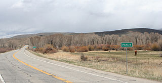
Parlin is an unincorporated community and a U.S. Post Office in Gunnison County, Colorado, United States. The Parlin Post Office has the ZIP Code 81239.

Ensenada is a census-designated place (CDP) in Rio Arriba County, New Mexico, United States. The population was 107 at the 2010 census. It had a post office from 1906 to 1958.
Devault is an unincorporated community in Charlestown Township in Chester County, Pennsylvania, United States. Devault is located at the intersection of Pennsylvania Route 29, Phoenixville Pike, and Charlestown Road.
Piltzville is a census-designated place (CDP) in Missoula County, Montana, United States. The population was 395 at the 2010 census.


