Barbican tube station

Last updated

Barbican Underground no-text.svg
Barbican tube station platform view with estate tower.jpg
View of Barbican station platforms, with the Barbican Estate towers in the background, 2014
Open street map central london.svg
Red pog.svg
Barbican
Location of Barbican in Central London
Location Barbican
Local authority City of London
Managed by London Underground
Number of platforms4 (2 in use)
Fare zone 1
London Underground annual entry and exit
2018Decrease2.svg 10.08 million [1]
2019Increase2.svg 10.47 million [2]
2020Decrease2.svg 2.54 million [3]
2021Increase2.svg 3.47 million [4]
2022Increase2.svg 5.36 million [5]
National Rail annual entry and exit
2006–07 0.045 million [6]
2007–08Increase2.svg 0.052 million [6]
2008–09Decrease2.svg 0 (closed) million [6]
Key dates
23 December 1865 (23 December 1865)Opened as Aldersgate Street [7] [8]
1 November 1910Renamed Aldersgate [7] [8]
24 October 1924Renamed Aldersgate & Barbican [7] [8]
1 December 1968Renamed Barbican [7] [8] [9]
1976Services from Great Northern line via Widened Lines ceased
1982Electrified services from Bedford commenced
2009 Thameslink services ceased
24 May 2022Opened access to Farringdon (Elizabeth line)
Other information
External links
WGS84 51°31′13″N0°05′52″W / 51.5202°N 0.0977°W / 51.5202; -0.0977
Underground sign at Westminster.jpg  London transportportal

Barbican is a London Underground station situated near the Barbican Estate, on the edge of the ward of Farringdon Within, in the City of London in Central London. It has been known by various names since its opening in 1865, mostly in reference to the neighbouring ward of Aldersgate.

Contents

The station is served by the Circle, Hammersmith & City and Metropolitan lines, and is situated between Farringdon and Moorgate stations, in Travelcard Zone 1. [10] Platform 2, serving westbound trains, is connected by a single lift to Farringdon station on the Elizabeth line. Until 2009 Barbican was additionally served by Thameslink services to and from Moorgate. [11]

Location

Barbican station lies in an east–west-aligned cutting with cut-and-cover tunnels at either end. [12] The modern entrance gives access from Aldersgate Street, through a 1990s building, [13] to a much older footbridge leading to the eastern end of the platforms. [note 1] To the north of the station are the rears of buildings that face onto Charterhouse Street, Charterhouse Square and Carthusian Street. [12] To the south are the rears of buildings that face onto Long Lane, and to the west is Hayne Street. [12] The station is close to the Barbican Estate, Barbican Centre, City of London School for Girls, St Bartholomew-the-Great, and Smithfield. [12] The Eastern Ticket Hall entrance to Farringdon Elizabeth line station is one street west of the station entrance, on the corner of Long Lane and Lindsey Street. A single lift connects directly from the Elizabeth line onto the westbound platform at Barbican.

History

The station was opened with the name Aldersgate Street on 23 December 1865 [8] on the Moorgate extension from Farringdon. [7] [14] It was built on the site of an earlier building at 134 Aldersgate Street, which for many years had a sign claiming "This was Shakespeare's House". [15] The building was very close to the nearby Fortune Playhouse, and a subsidy roll from 1598 shows a "William Shakespeare" as the owner of the property, however, there is no documentary evidence indicating they and the playwright were the same person.

The station, which has no surface building, [16] had its name shortened to Aldersgate on 1 November 1910 [7] [8] and was renamed again on 24 October 1924 as Aldersgate & Barbican, [7] [8] although tube maps and London A to Zs continued to show it as Aldersgate. [17] On 1 December 1968 the station's name was simplified to Barbican. [7] [8] [9]

Train services were disrupted during the Second World War when the station suffered severe bomb damage in the Blitz, particularly in December 1940. [18] This led to the removal of the upper floors, [13] and in 1955 the remainder of the street-level building was also demolished and the glass roof was replaced with awnings. [19] [20] This urged John Betjeman to write his poem Monody on the Death of Aldersgate Station. [20] [21]

Increasing traffic by other companies, including goods traffic, led to the track between King's Cross and Moorgate being widened to four tracks in 1868; the route was called the 'City Widened Lines'. Suburban services from the Midland Railway ran via Kentish Town and the Great Northern Railway ran via Kings Cross. British Rail services to Moorgate were initially steam operated before being converted to Cravens-built diesel multiple units and British Rail Class 31 locomotives class hauling non-corridor stock which remained in operation until the mid-1970s.

Passenger trains from the Great Northern line, via the York Road and Hotel curves at King's Cross to the Widened Lines, ran until the Great Northern's electrification on 1976. The City Widened Lines were renamed the Moorgate line [22] when overhead electrification was installed in 1982, allowing the Midland City Line service to run from Bedford via the Midland Main Line to Moorgate on the Thameslink service. The Thameslink platforms at Barbican were closed again in March 2009 as part of the Thameslink Programme to allow Farringdon to have its main line platforms extended across Thameslink's Moorgate branch. [14] [23] As a result, Barbican now serves Underground lines only.

The old entrance in 1981 London Barbican station entrance on Aldersgate Street, 1981 geograph-3256175-by-Ben-Brooksbank.jpg
The old entrance in 1981
Modern entrance to Barbican Barbican Station front 2020.jpg
Modern entrance to Barbican

The modern station is mostly open to the elements, [13] though there are some short canopies. The remains of the supporting structure for a glass canopy over all four platforms (removed in the 1950s) may still be seen. [13] At the west end of the platforms may be seen the beginnings of the complex of tunnels leading under Smithfield meat market. [24] Livestock for the market was at one time delivered by rail and there was a substantial goods yard under the site of the market. [25] [26]

Platform 1 is the most northerly, serving eastbound London Underground services. [27] [28] Platforms 2 and 3 form an island platform, with platform 2 serving westbound services. [27] [28] Platform 2 contains a lift to the Elizabeth line platforms; it is the only platform with step-free access. [29] Platforms 3 and 4 are out of use. [13] A display on the history of the station, including text and photographs, is just inside the barriers, on the southern side of the main entrance corridor.[ citation needed ]

The station has a commemorative plaque affixed to one of its walls in memory of the station's deceased cat Pebbles. [30]

Incidents and accidents

On 16 December 1866, three passengers were killed, a guard was seriously injured and one other person suffered shock when a girder collapsed onto a passenger train in the station. [31] The accident was the first to include multiple passengers on the underground network. Four people died during the accident, and a fifth (a workman involved in the accident) died while awaiting trial. Service on the line was running again only 30 minutes after the accident. [32]

On 26th April 1897, a bomb exploded under a seat in a first-class carriage in the station, injuring ten people of whom two died later. The perpetrators were never identified, but it was believed to have been part of a Fenian campaign following 3 other bombs in 1883-5. [33]

Services

The Thameslink lines on the south side of the station are no longer in use. The signal box seen here (R) was demolished in January 2015 as part of the Crossrail redevelopment. Barbican tube station MMB 05.jpg
The Thameslink lines on the south side of the station are no longer in use. The signal box seen here (R) was demolished in January 2015 as part of the Crossrail redevelopment.

The station is served by the Metropolitan, Hammersmith & City and Circle lines. All three lines share the same pair of tracks from Baker Street Junction to Aldgate Junction making this section of track one of the most intensely used on the London Underground network.

Circle line

The typical service in trains per hour (tph) is: [34]

Hammersmith & City line

The typical service in trains per hour (tph) is: [34]

Metropolitan line

The Metropolitan Line is the only line to operate express services, though currently this is only during peak times (Eastbound 06:30–09:30 / Westbound 16:00–19:00). Fast services run non-stop between Wembley Park, Harrow-on-the-Hill and Moor Park, Semi-fast services run non-stop between Wembley Park and Harrow-on-the-Hill. [35]

The typical off-peak service in trains per hour (tph) is: [36]

Off-peak services to/from Watford terminate at Baker Street

The typical peak time service in trains per hour (tph) is: [36]

Elizabeth line

Elizabeth line platforms at Farringdon are connected to Barbican's westbound platform. Crossrail platform at Farringdon.jpg
Elizabeth line platforms at Farringdon are connected to Barbican's westbound platform.

Farringdon's Barbican ticket hall for the Elizabeth line is just to the west of Barbican station along Long Lane. [37] This construction involved significant changes at the western end of the station, including the demolition of the former signal box [13] to construct a lift shaft from the Elizabeth line station to the westbound Underground platform only. The original plan of a new footbridge spanning the tracks to the eastbound platform was not proceeded with on the grounds of engineering difficulties. [38] [39] Work was anticipated to be completed in 2018, but was completed in May 2022. [40] [41]

Preceding station Underground no-text.svg London Underground Following station
Farringdon
towards Hammersmith
Circle line
Moorgate
towards Edgware Road via  Aldgate
Hammersmith & City line Moorgate
towards Barking
Farringdon Metropolitan line Moorgate
towards Aldgate
Internal connection
Preceding station Elizabeth line roundel (no text).svg Elizabeth line Following station
Tottenham Court Road
towards Paddington
Elizabeth line
transfer at Farringdon
Liverpool Street
towards Abbey Wood
Former services
Preceding station Underground no-text.svg London Underground Following station
Farringdon
towards Hammersmith
Metropolitan line
Hammersmith branch (1864–1990)
Moorgate
towards Barking
Disused Railways
Preceding station National Rail logo.svg National Rail Following station
Farringdon   First Capital Connect
City Widened Lines
Peak hours only
  Moorgate
Farringdon   Great Northern Railway
Widened Lines
  Moorgate

Connections

London Buses routes serve the station. [42]

Notes and references

Notes

  1. Aldersgate Street is where the station has always stood. The street itself took its name from Aldersgate, a gate in the old London Wall. [13]

Related Research Articles

<span class="mw-page-title-main">Thameslink</span> Mainline route in the British railway system

Thameslink is a mainline route on the British railway network, running from Bedford, Luton, St Albans City, Peterborough, Welwyn Garden City, London Blackfriars and Cambridge via central London to Sutton, Orpington, Sevenoaks, Rainham, Horsham, Three Bridges, Brighton and East Grinstead. The network opened as a through service in 1988, with severe overcrowding by 1998, carrying more than 28,000 passengers in the morning peak. All the services are currently operated by Govia Thameslink Railway. Parts of the network, from Bedford to Three Bridges, run 24 hours a day, except on early Sunday mornings and during maintenance periods.

<span class="mw-page-title-main">King's Cross Thameslink railway station</span> Former Thameslink and Metropolitan Railway Station in Central London

King's Cross Thameslink station is a closed railway station in central London, England. It is located on Pentonville Road, around 250 metres (0.2 mi) east of King's Cross mainline station. At the time of closure, in 2007, it was served by Thameslink trains and managed by First Capital Connect. Services have been transferred to a new station underneath St Pancras.

<span class="mw-page-title-main">Moorgate station</span> London Underground and railway station

Moorgate is a central London railway terminus and connected London Underground station on Moorgate in the City of London. Main line railway services for Hertford, Welwyn Garden City and Stevenage are operated by Great Northern, while the Underground station is served by the Circle, Hammersmith & City, Metropolitan and Northern lines.

<span class="mw-page-title-main">Old Street station</span> London Underground and railway station

Old Street is an interchange station at the junction of Old Street and City Road in Central London for London Underground and National Rail services.

<span class="mw-page-title-main">Ealing Broadway station</span> London Underground and railway station

Ealing Broadway is a major single-level interchange station located in Ealing, in the London Borough of Ealing, West London for London Underground services and also Elizabeth line services on the National Rail Great Western Main Line.

<span class="mw-page-title-main">Farringdon station</span> National rail and London Underground station

Farringdon is an interchange station located in Clerkenwell, London, England, in the London Borough of Islington, just outside the boundary of the City of London for London Underground, Elizabeth line and National Rail services.

<span class="mw-page-title-main">Euston Square tube station</span> London Underground station

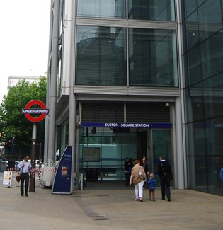
Euston Square is a London Underground station at the corner of Euston Road and Gower Street, just north of University College London – its main (south) entrance faces the tower of University College Hospital. The multi-interchange Euston station is beyond Euston Square Gardens, which is one street east. The station is between Great Portland Street and King's Cross St Pancras stations on the Circle, Hammersmith & City and Metropolitan lines in Travelcard Zone 1.

<span class="mw-page-title-main">Aldgate East tube station</span> London Underground station

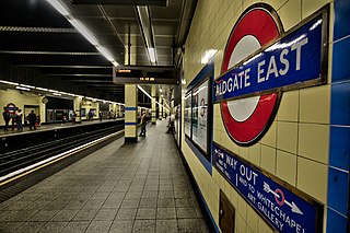
Aldgate East is a London Underground station on Whitechapel High Street in Whitechapel, in London, England. It takes its name from the City of London ward of Aldgate, the station lying to the east of the ward. It is on the Hammersmith & City line between Liverpool Street and Whitechapel, and on the District line between Tower Hill and Whitechapel, in Travelcard Zone 1.

<span class="mw-page-title-main">Whitechapel station</span> National rail, London Underground and Overground station

Whitechapel is an interchange station in Whitechapel, East London for London Underground, London Overground and Elizabeth line services. The station is located behind a street market of the same name and opposite Tower Hamlets Town Hall. It lies between Aldgate East and Stepney Green stations on the District and Hammersmith & City lines, between Shoreditch High Street and Shadwell stations on the East London Line. To the West of Whitechapel on the Elizabeth Line is Liverpool Street, to the East the line splits with one branch going to Stratford and one to Canary Wharf. It is in Travelcard Zone 2.

<span class="mw-page-title-main">High Street Kensington tube station</span> London Underground station

High Street Kensington is a London Underground station on Kensington High Street, in Kensington. The station is on the Circle line between Gloucester Road and Notting Hill Gate, and the District line between Earl's Court and Notting Hill Gate and is in Travelcard Zone 1. Kensington Arcade forms the entrance to the station.

<span class="mw-page-title-main">Great Portland Street tube station</span> London Underground station

Great Portland Street is a London Underground station near Regent's Park. It is between Baker Street and Euston Square stations on the Circle, Hammersmith & City and Metropolitan lines. Great Portland Street station is listed as a building of National Significance and lies in Travelcard Zone 1.

<span class="mw-page-title-main">Barons Court tube station</span> London Underground station

Barons Court is a London Underground station in West Kensington in the London Borough of Hammersmith and Fulham, Greater London. This station serves the District line and the Piccadilly line. Barons Court is between West Kensington and Hammersmith on the District line, and between Earl's Court and Hammersmith on the Piccadilly line and is in Travelcard Zone 2. East of the station, the Piccadilly line descends into tunnel towards Earl's Court and the District line continues in a cutting to West Kensington. The station is the last open air stop for eastbound trains on the Piccadilly line until Arnos Grove and has cross-platform interchange with the District line.

<span class="mw-page-title-main">Stepney Green tube station</span> London Underground station

Stepney Green is a London Underground station located on Mile End Road in Stepney, London, United Kingdom. It is between Whitechapel and Mile End on the District line and the Hammersmith & City line, and is in Travelcard Zone 2.

<span class="mw-page-title-main">Bow Road tube station</span> London Underground station

Bow Road is a London Underground station located on Bow Road in Bow, London, England. It is on the District and Hammersmith & City lines. The station is interlinked as an out of station interchange (OSI) with Bow Church station on the Docklands Light Railway which is about 300 m (980 ft) away via Bow Road. The two stations are classed as a single station for ticketing purposes as well as on tube maps but both are managed separately.

<span class="mw-page-title-main">Bromley-by-Bow tube station</span> London Underground station

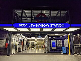
Bromley-by-Bow is a London Underground station located on the Blackwall Tunnel Northern Approach Road in the Bromley-by-Bow area of London, United Kingdom. The station is below the Blackwall Tunnel Northern Approach Road and lies between Bow Road and West Ham stations on the District and Hammersmith & City lines, and is in both Travelcard Zones 2 and 3.

<span class="mw-page-title-main">Ruislip tube station</span> London Underground station

Ruislip is a London Underground station in Ruislip in west London. The station is on the Uxbridge branch of both the Metropolitan line and Piccadilly line, between Ruislip Manor and Ickenham stations. The station is located on Station Approach. It is in Travelcard Zone 6. It is the oldest station on the Uxbridge branch and was originally the only intermediate station on the line between Uxbridge and Harrow-on-the-Hill.

<span class="mw-page-title-main">Greenford station</span> London Underground & National Rail station

Greenford is a London Underground and National Rail station in Greenford, Greater London, and is owned and managed by London Underground. It is the terminus of the National Rail Greenford branch line, 2 miles 40 chains down the line from West Ealing and 9 miles 6 chains measured from London Paddington. On the Central line, it is between Perivale and Northolt stations while on National Rail, the next station to the south on the branch is South Greenford.

<span class="mw-page-title-main">East Acton tube station</span> London Underground station

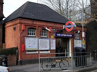
East Acton is a London Underground station in East Acton in London Borough of Hammersmith and Fulham. The station is on the Central line, between White City and North Acton stations, and in Travelcard Zone 2. Wormwood Scrubs, Queen Charlotte's and Chelsea Hospital, Hammersmith Hospital, Wormwood Scrubs prison and Imperial College Hammersmith branch are accessible from the station.

<span class="mw-page-title-main">Hillingdon tube station</span> London Underground station

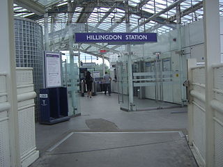
Hillingdon tube station is a London Underground station in North Hillingdon in the London Borough of Hillingdon, West London. Located between Uxbridge and Ickenham, it is in Travelcard Zone 6. It is the penultimate station on the Uxbridge branch of both the Metropolitan line and the Piccadilly line. Resited in 1992, it is also the most recently constructed station on the Metropolitan line.

<span class="mw-page-title-main">Paddington tube station (Bakerloo, Circle and District lines)</span> London Underground station

Paddington is a London Underground station served by the Bakerloo, Circle and District lines. It is located on Praed Street to the south of Paddington mainline station and has entrances from Praed Street and from within the mainline station. On the Bakerloo line the station is between Warwick Avenue and Edgware Road and on the Circle and District lines it is between Bayswater and Edgware Road. It is in London Fare Zone 1.

References

  1. "Station Usage Data" (CSV). Usage Statistics for London Stations, 2018. Transport for London. 23 September 2020. Archived from the original on 14 January 2023. Retrieved 11 October 2023.
  2. "Station Usage Data" (XLSX). Usage Statistics for London Stations, 2019. Transport for London. 23 September 2020. Archived from the original on 9 November 2020. Retrieved 9 November 2020.
  3. "Station Usage Data" (XLSX). Usage Statistics for London Stations, 2020. Transport for London. 16 April 2021. Retrieved 1 January 2022.
  4. "Station Usage Data" (XLSX). Usage Statistics for London Stations, 2021. Transport for London. 12 July 2022. Retrieved 7 September 2022.
  5. "Station Usage Data" (XLSX). Usage Statistics for London Stations, 2022. Transport for London. 4 October 2023. Retrieved 10 October 2023.
  6. 1 2 3 "Estimates of station usage". Rail statistics. Office of Rail Regulation. Please note: Some methodology may vary year on year.
  7. 1 2 3 4 5 6 7 8 Butt (1995), page 14
  8. 1 2 3 4 5 6 7 8 Hywel, Williams (2004). "Renamed Stations". Underground History. Archived from the original on 1 May 2015. Retrieved 1 May 2015.
  9. 1 2 Butt (1995), page 26
  10. Standard Tube Map (PDF) (Map). Not to scale. Transport for London. November 2022. Archived (PDF) from the original on 7 November 2022. Retrieved 12 November 2022.
  11. "Taking a look inside Crossrail's Farringdon station". www.ianvisits.co.uk. Retrieved 25 May 2022.
  12. 1 2 3 4 "Barbican Tube Station". Google Maps. Retrieved 1 May 2015.
  13. 1 2 3 4 5 6 7 "Barbican". Metropolitan. Archived from the original on 1 May 2015. Retrieved 1 May 2015.
  14. 1 2 Feather, Clive. "Hammersmith & City line". Clive's Underground Line Guides. Archived from the original on 8 April 2015. Retrieved 28 April 2015.
  15. Winter, William (1910). Seeing Europe with Famous Authors: Literary Shrines of London. London: Moffat, Yard & Co. Archived from the original on 28 April 2015. Retrieved 1 June 2007.
  16. "Tube Stations that have no surface buildings". Tube Facts and Figures. Geofftech. Archived from the original on 10 February 2015. Retrieved 1 May 2015.
  17. "Harry Beck Tube Map". London Transport Museum. 1957. Retrieved 26 July 2023.
  18. "Air raid damage on Aldersgate Street". London Transport Museum. 1 January 1941. Archived from the original on 28 April 2015. Retrieved 28 April 2015.
  19. "The Underground at War". Nick Cooper. 2010. Archived from the original on 28 April 2015.
  20. 1 2 Martin, Andrew (2013). Underground Overground: A Passenger's History of the Tube. London: Profile Books. p. 33. ISBN   978-1846684784.
  21. Rhys (25 May 2008). "It all started with a ghost: A Monody". It all started with a ghost. Retrieved 12 October 2018.
  22. Network Rail (April 2001). South Zone Sectional Appendix. Vol. Module SO. p. SO280 1/119. SO/SA/001A. (Retrieved 2011-12-10)
  23. "Thameslink Programme - FAQ". First Capital Connect. Archived from the original on 6 February 2009.
  24. diamond, geezer (8 June 2013). "Barbican". flickr . Archived from the original on 1 May 2015. Retrieved 1 May 2015."The disused signal box, the tunnels beneath Smithfield, and the future Crossrail entrance."
  25. Ian, Mansfield (25 May 2012). "Photos – The railway tunnels underneath Smithfield Meat Market". Subterranean Stuff, Transport Issues. IanVisits. Archived from the original on 1 May 2015. Retrieved 1 May 2015.
  26. Lemmo (25 June 2012). "Fulsome Farringdon: Part 1". London Terminals. London Reconnections. Archived from the original on 17 March 2015. Retrieved 1 May 2015.
  27. 1 2 Feather, Clive. "Circle line". Clive's Underground Line Guides. Archived from the original on 1 May 2015. Retrieved 1 May 2015.
  28. 1 2 Feather, Clive. "Metropolitan line". Clive's Underground Line Guides. Archived from the original on 1 May 2015. Retrieved 1 May 2015.
  29. "Step-free Tube Guide" (PDF). Transport for London. December 2023. Retrieved 8 February 2024.
  30. "London remembers Pebbles the station cat".
  31. "Accident Returns: Extract for the Accident at Aldersgate Street on 19th December 1866". 11 January 1867. Retrieved 28 April 2015.
  32. "Disaster at Barbican: The Tube's First Tragedy". Londonist. 12 November 2014.
  33. Alan A Jackson (1986). London's Metropolitan Railway. David & Charles, Newton Abbot. p. 123. ISBN   0-7153-8839-8.
  34. 1 2 "Circle and Hammersmith & City line WTT" (PDF). Transport for London. Archived from the original (PDF) on 11 November 2016.
  35. "CULG - Metropolitan Line". www.davros.org. Retrieved 19 March 2017.
  36. 1 2 "Metropolitan line WTT" (PDF). Transport for London. Archived from the original (PDF) on 1 July 2016.
  37. "Crossrail - Farringdon (1)". Crossrail. February 2005. Archived from the original on 16 December 2009.
  38. "Crossrail Context Report: City of London" (PDF). Crossrail. Archived from the original (PDF) on 22 July 2011. Retrieved 5 November 2010.
  39. "Taking a look inside Crossrail's Farringdon station". www.ianvisits.co.uk. Retrieved 4 June 2020.
  40. "Stations – Farringdon". Crossrail Construction Programme. Crossrail. Archived from the original on 1 May 2015. Retrieved 1 May 2015.
  41. "Elizabeth line opens and welcomes excited passengers". BBC News. Retrieved 25 May 2022.
  42. "Buses from Barbican" (PDF). TfL. May 2022. Retrieved 20 May 2022.

Further reading