North London line

Last updated

North London line
Unit 378005 at Canonbury.jpg
Overview
StatusOperational
Owner Network Rail
Locale Greater London
Termini
Stations23
Service
Type
System
Depot(s) Willesden TMD
Rolling stock
History
Opened1869 (1869)
Technical
Number of tracks
  • Two (mostly)
  • Four (York Way–Arundel Square)
Track gauge 1,435 mm (4 ft 8+12 in) standard gauge
Electrification
Route map
North London line.png
(Click to expand)
BSicon CONTg.svg
BSicon ldACCx-L.svg
BSicon dBHF.svg
BSicon ldACC-M.svg
BSicon dKBHFa.svg
BSicon ldACCx-R.svg
BSicon udKBHFa.svg
Richmond National Rail logo.svg District line roundel (no text).svg
BSicon vUSTxr.svg
BSicon utv-SHI2+l.svg
BSicon uv-SHI2+l.svg
BSicon udSHI2r.svg
BSicon utv-STR.svg
BSicon vUSTxl.svg
Note: shared tracks with District line
from Richmond to Gunnersbury
BSicon CONTgq.svg
BSicon STRr.svg
BSicon utSTR.svg
BSicon STR.svg
BSicon utSTR.svg
BSicon lHSTACC.svg
BSicon STR.svg
Kew Gardens District line roundel (no text).svg
BSicon dWASSERq.svg
BSicon utSTR.svg
BSicon hKRZWae.svg
BSicon dWASSERq.svg
BSicon CONTgq.svg
BSicon HSTq.svg
BSicon utSTR.svg
BSicon KRZo+xl.svg
BSicon lHST.svg
BSicon vABZq+rl.svg
BSicon CONTfq.svg
BSicon utSTR.svg
BSicon STR.svg
BSicon vSTR-eDST.svg
Kew (1853–1866)
BSicon utSTR.svg
BSicon lINT.svg
BSicon SHI1c2.svg
BSicon STR.svg
BSicon v-SHI3r.svg
BSicon vSHI1r-.svg
Gunnersbury District line roundel (no text).svg
BSicon uCONTgq.svg
BSicon STRc2.svg
BSicon utSTRr.svg
BSicon STR~L.svg
BSicon mABZgr.svg
BSicon STR~R.svg
Arrow Blue Left 001.svg
District line via Earl's Court
(former freight/Super Outer Circle link)
BSicon uvCONTgq.svg
BSicon udvSTRq.svg
BSicon mvKRZvu.svg
BSicon udvSTRq.svg
BSicon uvCONTfq.svg
BSicon vSHI2g+l-.svg
South Acton Junction
BSicon STR.svg
BSicon uexSTR+l.svg
BSicon uexCONTfq.svg
Arrow Blue Right 001.svgformer link to Acton Town
BSicon HUB-L.svg
BSicon HSTACC.svg
BSicon uexKXBHFe-R.svg
BSicon exSTR.svg
South Acton
BSicon eKRWg+l.svg
BSicon exKRWr.svg
former freight link
BSicon exCONTgq.svg
BSicon eABZgr.svg
BSicon ACC.svg
BSicon GRZq.svg
BSicon GRZq.svg
BSicon lELC.svg
Acton Central
(
third rail DC
overhead AC
changeover)
BSicon CONTgq.svg
BSicon KRZo+k2.svg
BSicon kABZq+3.svg
BSicon CONTfq.svg
BSicon HUBaq.svg
BSicon kABZg+1.svg
BSicon HUB+r.svg
Acton Wells Junction
BSicon -CONTgq.svg
BSicon uCONTgq-.svg
BSicon ^mKRZo-KRZo.svg
BSicon HUB.svg
BSicon mvSTRq.svg
BSicon -CONTfq.svg
BSicon uCONTfq-.svg
BSicon HUBaq.svg
BSicon ABZgl.svg
BSicon HUBr.svg
BSicon STRq.svg
BSicon CONTfq.svg
BSicon CONTgq.svg
BSicon ABZq+r.svg
BSicon STRq.svg
BSicon SHI3l.svg
BSicon ABZg+r.svg
BSicon vSHI3+r-.svg
BSicon STR.svg
BSicon STRc2.svg
BSicon hSTRa.svg
BSicon lvDST-.svg
BSicon dSTR3.svg
Old Oak sidings
BSicon STR.svg
BSicon STRc2.svg
BSicon hKRZ3+1.svg
BSicon STRc4.svg
BSicon kSTRc2.svg
BSicon kSTR3+l.svg
BSicon STRl.svg
BSicon ABZq1.svg
BSicon STRc4.svg
BSicon hKRZ.svg
BSicon STRq.svg
BSicon cSTRq.svg
BSicon CONTf@Fq.svg
BSicon kLLSTR+1.svg
BSicon hSTR.svg
BSicon STRc2.svg
BSicon STR3+l.svg
BSicon lCONTf@Gq.svg
Arrow Blue Right 001.svg
Watford DC and
Bakerloo lines (northbound)
BSicon STRc2.svg
BSicon HUBaq.svg
BSicon hACC.svg
BSicon HUBeq.svg
BSicon ACC3+1.svg
BSicon STRc4.svg
Willesden Junction Bakerloo line roundel (no text).svg
BSicon STRc2.svg
BSicon hKRZ3+1.svg
BSicon STRc4.svg
BSicon STRc2.svg
BSicon STR2+1.svg
BSicon STR3+1.svg
BSicon STRc34.svg
BSicon lhSTRe@g.svg
BSicon ABZg+l.svg
BSicon STRq.svg
BSicon CONTfq.svg
BSicon LSTR+1.svg
BSicon STRc14.svg
BSicon ABZg+4.svg
Arrow Blue Down 001.svg
Watford DC and
Bakerloo lines (southbound)
BSicon ABZgl.svg
BSicon ENDEeq.svg
Kensal Green turnback siding
BSicon eHST.svg
Kensal Green & Harlesden
BSicon HSTACC.svg
Kensal Rise
BSicon HST.svg
Brondesbury Park
BSicon HST.svg
Brondesbury
BSicon CONTgq-.svg
BSicon u-CONTfaq.svg
BSicon HUBa@f.svg
BSicon umvSTRq.svg
BSicon KRZu-mKRZu.svg
BSicon u-CONTfq.svg
BSicon CONTfq-.svg
Chiltern Main Line
Metropolitan line (wraps Jubilee line tracks)
BSicon uvCONTgq.svg
BSicon ulBHF-.svg
BSicon HUB.svg
BSicon uvSTRq.svg
BSicon mKRZvu.svg
BSicon uvCONTgfeq.svg
BSicon HUBl.svg
BSicon HUBq.svg
BSicon INT.svg
BSicon HUB+r.svg
West Hampstead ThameslinkSymbol.svg Jubilee line roundel (no text).svg
BSicon LSTR+l.svg
BSicon KRZo.svg
BSicon HUB.svg
BSicon STRq.svg
BSicon CONTfq.svg
BSicon CONTgq.svg
BSicon KRZo.svg
BSicon HUBe.svg
BSicon BHFq.svg
BSicon CONTfq.svg
BSicon tHSTa@f.svg
Finchley Road & Frognal
BSicon utCONTgq.svg
BSicon mtKRZto.svg
BSicon utCONTfq.svg
Hampstead Heath Tunnel
over Northern line
BSicon PORTALg.svg
BSicon HSTACC.svg
Hampstead Heath
BSicon vSTR2-.svg
BSicon vSTR-.svg
BSicon STRc3.svg
freight link
BSicon lvACC.svg
BSicon STRc1.svg
BSicon vBHF-.svg
BSicon ABZq+4.svg
BSicon exdSTRc2.svg
BSicon eABZq+3.svg
BSicon dCONTfq.svg
Gospel Oak
BSicon LSTR2.svg
BSicon STRc3.svg
BSicon eABZg+l.svg
BSicon excdSTRr+1.svg
BSicon exSTRc4.svg
BSicon LSTR.svg
BSicon LSTR.svg
BSicon STRc1.svg
BSicon KRZ2+4o.svg
BSicon STRc3.svg
BSicon ABZg2.svg
BSicon STRc3.svg
BSicon ABZg2.svg
BSicon STRc3.svg
BSicon STRc1.svg
BSicon HST.svg
BSicon LSTR+4.svg
Kentish Town West
BSicon STRc1.svg
BSicon CONTf.svg
BSicon STRc1.svg
BSicon KRZ2+4o.svg
BSicon STRc3.svg
BSicon STR+4.svg
BSicon STR.svg
BSicon STRc1.svg
BSicon CONTf.svg
BSicon ABZg+4.svg
BSicon STR.svg
BSicon eHST2.svg
BSicon STR+c3.svg
Primrose Hill
BSicon utCONTgq.svg
BSicon utSTRq.svg
BSicon STRc1.svg
BSicon utSTRq.svg
BSicon ABZg+4.svg
BSicon utSTRq.svg
BSicon utCONTfq.svg
BSicon ACC.svg
Camden Road
BSicon CONTgq.svg
BSicon ABZq+l.svg
BSicon ABZq+l.svg
BSicon ABZgr.svg
BSicon LSTR.svg
BSicon CONTgq.svg
BSicon KRZo.svg
BSicon KRZo.svg
BSicon KRZo.svg
BSicon STRr.svg
BSicon CONTgq.svg
BSicon ABZg+r.svg
BSicon STR.svg
BSicon STR.svg
BSicon hSTRa.svg
BSicon STR.svg
BSicon eHST.svg
Maiden Lane
BSicon CONTgq.svg
BSicon hKRZ.svg
BSicon ABZql.svg
BSicon KRZo.svg
BSicon CONTfq.svg
BSicon htSTRa.svg
BSicon STR.svg
BSicon utCONTgq.svg
BSicon mtKRZt.svg
BSicon utSTRq.svg
BSicon mKRZt.svg
BSicon utCONTfq.svg
BSicon tSTR2.svg
BSicon tSTRc3.svg
BSicon HSTACC.svg
Caledonian Road & Barnsbury
BSicon tdSTRc1.svg
BSicon tSTR2+4.svg
BSicon MFADE2+4.svg
BSicon v-SHI2gr.svg
HS1 continues under North London Line
BSicon HUBa@fq.svg
BSicon HUBq.svg
BSicon vACC.svg
BSicon HUB+r.svg
Highbury & Islington National Rail logo.svg Victoria line roundel (no text).svg
BSicon utdCONTgq.svg
BSicon utSTRq.svg
BSicon mvKRZt.svg
BSicon HUB.svg
BSicon utBHFq.svg
BSicon utCONTfq.svg
BSicon dCONTgq.svg
BSicon tSTRaq.svg
BSicon vKRZt.svg
BSicon HUBe.svg
BSicon tBHFq.svg
BSicon PORTALr.svg
BSicon CONTfq.svg
BSicon STR~L.svg
BSicon ABZg+l.svg
BSicon STR~R.svg
BSicon STRq.svg
BSicon dCONTfq.svg
BSicon vACC.svg
Canonbury
BSicon vSTR-eHST.svg
Mildmay Park
BSicon vUSTxr.svg
BSicon STRc2.svg
BSicon v-STR3.svg
BSicon dHST.svg
Dalston Kingsland
BSicon CONTgq.svg
BSicon lv-ACC@G.svg
BSicon exlv-BHF@F.svg
BSicon ABZr+1x2.svg
BSicon exSTRc3.svg
BSicon cdSTRc4.svg
BSicon tSTRa@g.svg
Dalston Junction
East London line
City Branch
BSicon exSTRc1.svg
BSicon exSTR2+4.svg
BSicon tSTRe@g.svg
BSicon exdSTRc3.svg
BSicon exSTRc1.svg
BSicon edABZg+4.svg
BSicon kABZg3.svg
Navarino Road Junction - Graham Road curve
BSicon CONTgq.svg
BSicon kABZq1.svg
BSicon KRZu+k4.svg
BSicon CONTfq.svg
BSicon ACC.svg
Hackney Central
BSicon ACC.svg
Homerton
BSicon STR.svg
BSicon tSTRl+4.svg
BSicon tCONTfq.svg
BSicon eHST.svg
Victoria Park
BSicon exCONTgq.svg
BSicon eABZgr.svg
former Victoria Park Junction North London Railway
BSicon ACC.svg
Hackney Wick
BSicon hbKRZWae.svg
BSicon STRc2.svg
BSicon ABZg3.svg
BSicon STR+1.svg
BSicon dSTR~L.svg
BSicon dSTRc4.svg
BSicon STR~R.svg
BSicon uSTR+l.svg
BSicon exBS2+r.svg
BSicon uCONTfq.svg
BSicon STR.svg
BSicon STR.svg
BSicon lINT~F.svg
BSicon utSTRa.svg
Stratford National Rail logo.svg Jubilee line roundel (no text).svg Central line roundel (no text).svg DLR no-text roundel.svg Elizabeth line roundel (no text).svg
BSicon CONTgq.svg
BSicon ABZqlr.svg
BSicon exSTR+r.svg
BSicon STRq.svg
BSicon lINT-Mq.svg
BSicon utSTR~L.svg
BSicon dSTRq.svg
BSicon utdSTR~R.svg
BSicon eABZq+l.svg
BSicon dCONTfq.svg
BSicon utCONTgq.svg
BSicon xmKRZt.svg
BSicon uSTRq.svg
BSicon PORTALr.svg
BSicon lINTACC-Mq.svg
BSicon utSTR~L.svg
BSicon udSTRq.svg
BSicon dPORTALl.svg
BSicon utdSTR~R.svg
BSicon xmKRZt.svg
BSicon utdCONTfq.svg
BSicon uCONTgq.svg
BSicon xmKRZ.svg
BSicon uKINTeq.svg
BSicon lINT-Lq.svg
BSicon utSTR~L.svg
BSicon BLa.svg
BSicon exSTR~L.svg
BSicon utSTR~R.svg
BSicon exSTR~R.svg
BSicon exvSTR2-.svg
BSicon dBLe.svg
BSicon uvKBHFa-BHF.svg
BSicon lvINTACC.svg
BSicon exSTRc3.svg
BSicon exdSTRc2.svg
BSicon exdSTR3.svg
Low Level
Jubilee line to StanmoreDLR to Lewisham
BSicon exSTRc1.svg
BSicon exv-STR+4.svg
BSicon uvSTR.svg
BSicon exdSHI2+l.svg
BSicon exdSTR3+1-.svg
BSicon exdSTRc4.svg
BSicon udSTRc2.svg
BSicon uSTRc2.svg
BSicon uv-STR3.svg
BSicon uvSTR3-.svg
Arrow Blue Down 001.svg
former EC&TJR route
to North Woolwich
BSicon uLSTR+1.svg
BSicon uLSTR+1.svg
BSicon uSTRc4.svg
BSicon uSTRc4.svg
BSicon uSTR+1.svg
BSicon uSTR+1.svg
BSicon uSTRc4.svg
BSicon uSTRc4.svg
BSicon uSTR.svg
BSicon uACC.svg
Stratford High Street
BSicon uSTR.svg
BSicon uACC.svg
Abbey Road
BSicon uCONTgq.svg
BSicon uSTRq.svg
BSicon uKRZu.svg
BSicon uKRZu.svg
BSicon HUBa.svg
BSicon uACCq.svg
BSicon uCONTfq.svg
BSicon CONTgq.svg
BSicon eABZq+r.svg
BSicon umKRZu.svg
BSicon umKRZu.svg
BSicon HUB.svg
BSicon ACCq.svg
BSicon CONTfq.svg
BSicon exkSTR2.svg
BSicon HUBaq.svg
BSicon uXACC-L.svg
BSicon HUBq.svg
BSicon uXACC-R.svg
BSicon HUBr.svg
West Ham National Rail logo.svg H&c line roundel (no text).svg District line roundel (no text).svg Jubilee line roundel (no text).svg
BSicon exkSTRc1.svg
BSicon uSTR.svg
BSicon exkSTRl+4.svg
BSicon uSTR.svg
BSicon exSTR+r.svg
BSicon uSTR.svg
BSicon uACC.svg
Star Lane
BSicon uCONTgq.svg
BSicon uSTR+r.svg
BSicon uSTR.svg
BSicon uSTR.svg
BSicon uXACC-L.svg
BSicon uXACC-M.svg
BSicon uXACC-R.svg
Canning Town Jubilee line roundel (no text).svg DLR no-text roundel.svg
BSicon uCONTgq.svg
BSicon uKRZo.svg
BSicon uSTRr.svg
BSicon uABZg2.svg
BSicon uSTRc3.svg
BSicon uABZgl.svg
BSicon uSTRq.svg
BSicon uSTRc1.svg
BSicon uKRZu.svg
BSicon uSTR+4.svg
BSicon uSTR+r.svg
BSicon uABZg+l.svg
BSicon uSTRq.svg
BSicon uSTRr.svg
BSicon exSTR.svg
BSicon uSTR.svg
DLR is elevated on line of Silvertown Tramway
from Tidal Basin to beyond Pontoon Dock
BSicon uSTR.svg
BSicon exSTR+l.svg
BSicon exSTRq.svg
BSicon exABZgr.svg
BSicon exHST.svg
BSicon uSTR.svg
Tidal Basin
BSicon uSTR.svg
BSicon exSTR.svg
BSicon uACC.svg
Royal Victoria
BSicon tCONTgq.svg
BSicon umKRZt.svg
BSicon tSTReq.svg
BSicon xABZg+r.svg
BSicon uSTR.svg
BSicon uSTR.svg
BSicon XBHF-L.svg
BSicon uXACC-R.svg
Custom House DLR no-text roundel.svg Elizabeth line roundel (no text).svg
BSicon uSTR.svg
BSicon eABZgl.svg
BSicon uSTRl.svg
BSicon exSTRq.svg
BSicon uCONTfq.svg
BSicon uACC.svg
BSicon eABZgl.svg
BSicon exSTRq.svg
BSicon exdCONTfq.svg
West Silvertown
 Arrow Blue Right 001.svg to Gallions
BSicon uACC.svg
BSicon STR.svg
Pontoon Dock
BSicon uSTR.svg
BSicon tSTRa.svg
Connaught Tunnel (27 ch long)
BSicon xmABZgl.svg
BSicon uSTRq.svg
BSicon mtKRZ.svg
BSicon uCONTfq.svg
BSicon POINTERg@fq.svg
BSicon exSTR.svg
BSicon tSTRe.svg
Silvertown Tramway was first EC&TJR route
BSicon exSTRl.svg
BSicon exSTRq.svg
BSicon exlBHF-.svg
BSicon eABZg+r.svg
Silvertown
BSicon PORTALf.svg
BSicon eBHF.svg
North Woolwich BSicon FERRY.svg
BSicon tKRZW.svg
BSicon tCONTf.svg

The North London line (NLL) is a railway line which passes through the inner suburbs of west, north-west, north, and north-east London, England between Richmond in the south-west and Stratford in the east, avoiding central London. Its route is a rough semicircle.

Contents

Although much of it originated as part of the North London Railway, the current route is the result of a series of amalgamations, closures and reopenings, and has a mix of third-rail and overhead electrical power supply. It remains heavily used by freight services in addition to the main London Overground (LO) service. [1] Between Richmond and Gunnersbury, London Underground's District line shares tracks with London Overground services; the entire route is owned and maintained by Network Rail.

TfL took over the line in 2007 and introduced new stock as well as putting the line on the Tube map. It closed for four months in 2010 between Gospel Oak and Stratford and had a reduced service for another year to allow platform extensions and signalling upgrades. [2]

From autumn 2024 the North London line and the West London section of the London Overground will be merged and named the Mildmay line (to honour the Mildmay Mission Hospital which treated victims of the HIV/AIDS crisis in the 1980s) and will be coloured light blue on the Tube map. [3]

History

Formation

The North London line between Richmond and North Woolwich derived from five connecting sections which were opened over 25 years from 1846:

Developments

The line from Broad Street to Kew Bridge and Richmond was electrified by the LNWR in 1916 on the fourth-rail DC system.

In 1944, passenger services on the NLR Poplar branch ceased. Freight traffic continued on the branch to the docks on the Isle of Dogs until 1980. The trackbed of the southern part of the branch, from Poplar to Bow, was used for the Docklands Light Railway (DLR) branch to Stratford.

The service was listed for closure in the 1963 Beeching Report, with losses claimed as being £69,000 per year (equivalent to £1,022,000in 2019). It was saved after a huge campaign. The line was Grant Aided under the Transport Act 1968 and came under threat when the Conservative Government of 1970–71 proposed to reduce Grant Aid funding. That threat, eventually lifted, led to the founding of a new campaign group, the North London Line Committee, which tried to work with British Rail management to promote the service.

In 1979, the North Woolwich to Stratford service was extended to Camden Road as the Crosstown Linkline service, using the same Cravens-built diesel multiple unit trains. There were no intermediate stations until, in 1980, Hackney Wick was opened, near the site of the former Victoria Park station and Hackney Central was re-opened; then Homerton re-opened in 1985 (the two latter stations had closed in 1944). New platforms were built at West Ham for interchange with the adjacent Underground station.

The part of the line between the West London and East Coast Main Lines was proposed in the mid-1990s to be used for Regional Eurostar services, which would travel from the lines into Waterloo International station to points north of London. A proposed link to Heathrow Airport would have also used the line between Willesden Junction and Acton. Regional Eurostar was eventually cancelled. [4]

Rolling stock

Old vs new: a Class 313 and its replacement, a Class 378 Capitalstar at Richmond E 313107 378017 Richmond.JPG
Old vs new: a Class 313 and its replacement, a Class 378 Capitalstar at Richmond

The line was originally operated by steam-hauled trains which were replaced after electrification by London and North Western Railway EMUs built from 1914 and augmented by later EMUs built in the 1930s by the London, Midland and Scottish Railway. These had all been replaced by the early 1960s with dedicated short-wheelbase trains (shared with the Watford DC line) built by the Southern Region at Eastleigh (using underframes built at Ashford) from 1957 which were later designated by British Railways as Class 501. These were succeeded by Southern Region Class 416 EMU for a short period, these units being allocated to Selhurst depot in south London. Class 416 trains were in turn succeeded by Class 313 EMUs, which worked the route until 2010 when London Overground introduced Class 378 Capitalstar four-car dual-voltage electric trains compatible with both 750 V DC third-rail and 25 kV AC overhead power sources, [5] and all of these units were by 2017 operating in 5-car formations to address the additional demand on the route.

Closures

In 1986, Broad Street station closed and the Tottenham Hale–Stratford link and the station at Lea Bridge ceased to be used by regular passenger trains. The line between Dalston and North Woolwich was electrified on the third-rail system and Broad Street services were diverted to North Woolwich using former Southern Region 2-EPB types built in the 1950s. The two-car trains soon proved too small and were replaced by three-car Class 313 electric multiple units. The new service was branded by British Rail as the North London Link, and some signs using this name still exist.

In December 2006, as with the Poplar branch (see above), the line between Stratford and North Woolwich was permanently closed to make a way for a future DLR extension from Canning Town to Stratford International (opened February 2011). The section south of Canning Town was not used by the DLR, as it is largely duplicated by the DLR King George V branch. Instead, the section became part of the Elizabeth line's branch to Abbey Wood, which opened in May 2022. The section south of Stratford had always been the 'Cinderella' end of the line, in that when there were operating problems it was common for trains to be turned short at Stratford.

Poor performance before the TfL takeover

Despite favourable performance figures, [6] the North London line used to be regarded by frequent travellers as offering a poor [7] and unreliable [8] service with extremely congested trains which were often cancelled shortly before they were due to arrive. A 2006 London Assembly report described the current service as "shabby, unreliable, unsafe and overcrowded", proposing the transfer of the service to Transport for London (TfL) as a solution to improve the quality of the service [9] due to upgrade plans [10] which coincided with the extension of the East London line. [11]

TfL

The North London line, as part of Silverlink, along with the West London line, Gospel Oak to Barking line and the Watford DC line, was transferred to Transport for London (TfL) in 2007 to form its new London Overground service. TfL began to remodel stations, integrate lines and, following the transfer and extension of the East London line, created an orbital rail service. TfL also brought in new trains and the lines, which previously appeared on tube maps following a public campaign, gained their own colour.

TfL closed the line in February 2010 between Gospel Oak and Stratford for the installation of a new signalling system and the rebuilding or extension of platforms to allow four-car trains to run on the line; most NLL platforms had been reduced in usable length (where they had not been originally short) in the late 1960s when services were reduced to three-carriage trains only. The line reopened on 1 June 2010 with a reduced service and none on Sundays, [2] and with the upgrade work completed, the full seven-day service resumed on 22 May 2011.

Former services

In addition to the primary Broad Street - Richmond service, there were services that linked Broad Street with Harrow & Wealdstone and Watford Junction on the Watford DC line. Most of these were routed via the line between South Hampstead and Camden Road, calling at Primrose Hill although some travelled via Hampstead Heath and joined the DC line at Willesden Junction. Prior to electrification in the 1960s, other services ran as far as Tring on the West Coast Main Line via Primrose Hill and Willesden Junction Main Line (now demolished). By the time that Broad Street closed in 1986, the Watford services operated only in the rush hours; they were diverted to Liverpool Street by way of a new link in Hackney, known as the Graham Road Curve. Trains were frequently cancelled owing to rolling stock shortages; these circumstances had begun some years earlier with service reductions and scrapping of trains in the late 1960s, followed in later years by closure of depots at Croxley Green and Stonebridge Park preventing stabling of spare stock. Along with what eventually became a lack of trains timetabled to serve Liverpool Street to match the needs of rush-hour passengers, this inevitably led to falling patronage. British Rail applied to close the service in 1990, and the last trains ran two years later.

In 2000, Anglia Railways started a service between Basingstoke and Ipswich, utilising parts of the North London line. The service was called London Crosslink and ran up to five times a day at roughly two-hourly intervals. The service called only at principal stations such as Staines, Feltham and Brentford. On the North London line, the trains called only at Stratford, Highbury & Islington, Camden Road (some services), West Hampstead and Willesden Junction. The service was withdrawn in 2002.

The AC electrification of the eastern part of the North London line uses the previously unelectrified northern pair of tracks, which were also partially singled at the same time. Between Canonbury and Highbury & Islington, there is a line which links to the East Coast Main Line at Finsbury Park. This used to carry passenger trains to and from various main line stations (such as Edgware, Alexandra Palace, High Barnet, Welwyn Garden City and others) over part of the North London line to Broad Street Station; however, with the electrification of the Great Northern Electrics suburban lines in 1976, trains were diverted into Moorgate and London King's Cross stations, so since then this link has only been used for freight trains. It too was singled concurrent with the AC electrification of the eastern part of the North London line.

Route

Track

Most of the line runs in a curve across north London. Only Richmond and Kew Gardens stations at the western end are south of the River Thames. The river crossing is made by Kew Railway Bridge on tracks which are shared with the London Underground District line. The location of the eastern extremity has varied over the years. Between 1944 and 1986, it was at Broad Street station; then it was switched to North Woolwich. Later, it was cut back to Stratford. A tunnel, the Hampstead Heath tunnel, runs under Hampstead between Finchley Road & Frognal and Hampstead Heath. The line is double track throughout, with quadruple track between York Way (near St. Pancras) and Arundel Square (near Highbury and Islington). The former North Woolwich branch included a section of single track between Custom House and North Woolwich stations, and the Broad Street branch was at one time formed of quadruple track.

During the February–May 2010 blockade, the Caledonian Road & Barnsbury, Highbury & Islington and Canonbury stations were rebuilt to allow the extended East London line to serve Highbury & Islington on fully segregated tracks on the south side of the cutting. Under the reinstated four-track arrangement, the North London line runs parallel to the double-track East London Line from Dalston Kingsland to Highbury and Islington. The line then becomes quadruple-track at Arundel Square, with passenger services using the inner pair of tracks and freight services using the outer pair, before the line reduces to double track at York Way, near St. Pancras.

Traction current supply

Originally, the line was electrified in 1914–15 using the fourth rail +420 V / -210 V system, as used by London Underground. This was changed in the 1970s to +630 V / 0 V; the trains (then EMUs of a design unique to this and the DC line) were modified to the same basic traction supply arrangements as SR 3rd rail EMUs; the centre/negative current rail was removed except where coincident four-rail running was required between Richmond and Gunnersbury for the Underground trains that share this section, the centre rail there being bonded to the running rail used for current return. The line is now electrified using that same third rail system from Richmond to Acton Central, but with overhead lines now used from Acton Central to Stratford. The line into Broad Street used third-rail supply and, when the through service to North Woolwich started in 1985, trains used the third rail throughout. When the trains were replaced a few years later by dual-voltage Class 313 trains, it became possible to use the overhead line equipment which had been added to parts of the line for the benefit of freight trains; there had been some unexpected difficulties with earth currents from the third rail system which this overcame. This use was steadily extended, and trains had to make a number of changes between traction current supplies during their short journey; these were at Hackney Wick, Dalston Kingsland, Camden Road and Acton Central. With the final upgrade of the line between Camden Road and Stratford, the need to change traction current systems on this stretch was eliminated, and now the only changeover takes place at Acton Central for the short section to Richmond. The line ran on third rail throughout the 1980s until 1996 when it was closed for conversion to overhead lines. In 2010, the last of the third-rail sections around Camden Road station were completely removed.

Connections

The line crosses, or comes into contact with, a very large number of other railway lines, especially lines radiating from central London. This does provide opportunities to move between different sectors of suburban London without having to enter the central zone.

Interchanges shown on the tube map

Other interchanges

Alternative stations – lines merge nearby

Former interchanges

Current operations

Service levels

Trains run seven days a week, from approximately 06:00 (09:00 Sundays) until 23:30. There are eight trains per hour between Stratford and Willesden Junction, four of which continue to Clapham Junction and four to Richmond.

The introduction[ when? ] of new four-car, air-conditioned trains, combined with improved signalling and passenger information, has dramatically overhauled the service, making it an effective alternative to travelling through central London for many orbital journeys.

East London line extension

From March 2011, the extended East London line connects to the NLL, with ELL services joining the line west of Dalston Kingsland, running to Highbury & Islington. [12] [13]

Five-car operation

Transport for London extended platforms at some stations along the route to prepare the line for five-car operations in 2015, a project aimed at combating overcrowding on the line. The project was successfully completed and the first five-car trains started to run in summer 2015.

Renaming

In July 2023, TFL announced that it would be giving each of the six Overground services unique names by the end of 2024. [14] [15] In February 2024, it was confirmed that the North London / West London section would be named the Mildmay line (to honour the Mildmay Hospital which treated victims of the HIV/AIDS crisis in the 1980s) and would be coloured blue on the updated network map. [3]

Map of the London Overground network, with the NLL connected to other lines London Overground map 2012.png
Map of the London Overground network, with the NLL connected to other lines

Proposed developments

Maiden Lane

Maiden Lane station may be reopened by Camden Council; [16] however, the Office of Rail Regulation has not included this in the current plans. [17]

Crossrail to Hounslow

Hounslow council has proposed that part of the North London line be used as a branch of Crossrail to Hounslow, [18] which would see Crossrail services serving Acton Central and South Acton. It was not included in the initial Crossrail bill but could form part of a later extension.

Old Oak Common Lane

Under the former government's plans for High Speed 2 line from London Euston to Birmingham, a new station called Old Oak Common was to be built by 2025 serving the North London line, West London line, High Speed 2 and Crossrail. The new government supports the idea after it had been opposed at first. [19]

North Acton

Another new station at North Acton is proposed for interchange with the Central line,[ citation needed ] but it might require the Central line station being moved to the east.

High Speed 2

The planned link between the proposed High Speed 2 line and the existing High Speed 1 line would have used the North London line alignment around Camden Road station, which might have reduced the existing or future capacity of the line. Its heavy investment in the line and the passenger growth on it has made Transport for London against the alignment's use as a link between the two High Speed lines. [20] That link has now been removed from the parliamentary bill.

Camden Highline

A new park utilising the former railway alignment between Camden Town and King's Cross was given planning permission in January 2023. [21] [22]

Closed stations

Silverlink Metro 313117 at North Woolwich on 9 December 2006, the final day of service at that station NLL-woolwich.jpg
Silverlink Metro 313117 at North Woolwich on 9 December 2006, the final day of service at that station

Closed stations apart from those on the closed sections of the line are:

City Extension

On 1 November 1865 the NLR opened its City Extension, mostly on a viaduct from a triangular junction at Dalston to Broad Street in the city, with these stations:

The extension closed on 30 June 1986, but although the track was lifted the viaduct remained in place. The route was re-opened in 2010 as part of the extended East London line, which, like the North London line, is operated by London Overground.

North Woolwich section

On 10 December 2006, the former Eastern Counties and Thames Junction Railway line between Stratford and North Woolwich was closed to allow building of a Docklands Light Railway line to Stratford International between Stratford and Canning Town. Part of the south end of the closed section is used by the Elizabeth line. [23]

NLL stations closed were:

DLR and Jubilee line services are not affected at the first three of those stations.

The DLR line to Stratford International uses the former NLL low-level platforms at Stratford. NLL trains now terminate at new platforms on the north side of the high-level station.

Related Research Articles

<span class="mw-page-title-main">Highbury & Islington station</span> London Underground and railway station

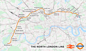
Highbury & Islington is an interchange station in the London Borough of Islington, North London for London Underground, London Overground and National Rail services

<span class="mw-page-title-main">Gospel Oak railway station</span> London Overground station

Gospel Oak railway station is in the London Borough of Camden in north-west London. It is situated the North London line, served by Mildmay line services between Clapham Junction/Richmond and Stratford, and is also the western passenger terminus of the Gospel Oak to Barking line, served by Suffragette line services to/from Barking Riverside. Passengers using Oyster cards are required to tap on interchange Oyster card readers when changing between the two lines. The station is in Travelcard Zone 2, and is managed by London Overground which runs all passenger trains at the station.

The North London Railway (NLR) company had lines connecting the northern suburbs of London with the East and West India Docks further east. The main east to west route is now part of London Overground's North London Line. Other NLR lines fell into disuse but were later revived as part of the Docklands Light Railway, and London Overground's East London Line. The company was originally called the East & West India Docks & Birmingham Junction Railway (E&WID&BJR) from its start in 1850, until 1853. In 1909, it entered into an agreement with the London and North Western Railway which introduced common management, and the NLR was taken over completely by the LNWR in 1922. The LNWR itself became part of the LMS from the start of 1923. The railways were nationalised in 1948 and most LMS lines, including the North London route, then came under the control of the London Midland Region of British Railways.

<span class="mw-page-title-main">Acton Central railway station</span> London Overground station

Acton Central railway station is on the London Overground, between South Acton and Willesden Junction, in Travelcard Zone 3. It is also where trains change power supply from overhead line equipment to third rail, or vice versa, depending on direction of travel.

<span class="mw-page-title-main">Camden Road railway station</span> London Overground station

Camden Road railway station in the London Borough of Camden, north London, is operated by London Overground. It is on the North London line and in Travelcard Zone 2.

<span class="mw-page-title-main">West London line</span> Clapham Junction-Willesden Junction rail route

The West London line (WLL) is a short railway in inner West London that links Willesden Junction in the north to Clapham Junction in the south. The line has always been an important cross-London link, especially for freight services. Southern and London Overground provide regular passenger services; detailed below.

<span class="mw-page-title-main">Dalston Kingsland railway station</span> London Overground station

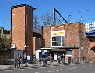
Dalston Kingsland railway station is a railway station on the North London Line in London, England. It is in the Dalston area of the London Borough of Hackney, on the western side of Kingsland High Street and opposite Ridley Road Market. The station and all trains serving it are operated by London Overground. It is in Travelcard Zone 2. Kingsland railway station was first opened on the site in 1850, but was replaced by Dalston Junction in 1865. The current station was opened by British Rail in 1983. Ticket barriers are in operation. The station straddles the boundary with the London Borough of Islington, with part of the platforms falling within Islington.

<span class="mw-page-title-main">Hackney Central railway station</span> London Overground station

Hackney Central is a London Overground station on the North London line in Hackney Central, north-east London. It lies between Dalston Kingsland and Homerton and is in Travelcard Zone 2. The station and all trains serving it are operated by London Overground services which are managed by Transport for London.

<span class="mw-page-title-main">Hackney Wick railway station</span> Railway station in London, England

Hackney Wick is a station on the North London Line in the area of Hackney Wick, East London. It is in Travelcard Zone 2. The station and all trains serving it are operated by London Overground. It opened on 12 May 1980 by British Rail as part of the Crosstown Linkline service between North Woolwich and Camden Road stations. Between Spring 2017 and May 2018 the station was rebuilt and modernised, including replacement of the footbridge by a subway. The new subway, in addition to linking the two platforms will, later in 2018, provide a cycle and pedestrian link between Hackney and Tower Hamlets.

<span class="mw-page-title-main">Homerton railway station</span> London Overground station

Homerton is a station on the North London line in the district of Homerton, East London. The station and all trains serving it are operated by London Overground. It is in London fare zone 2. The current station opened on 13 May 1985 to coincide with the introduction of the Richmond to North Woolwich through electric passenger service. The station is close to Homerton University Hospital and Hackney Marshes.

<span class="mw-page-title-main">Canonbury railway station</span> London Overground station in the London Borough of Islington

Canonbury railway station serves the districts of Canonbury and Highbury within the London Borough of Islington in north London. It is on London Overground's North London line and East London line. The station and all trains serving it are operated by London Overground, and the station is in Travelcard Zone 2. This location of the station is close to the boundary with the London Borough of Hackney.

<span class="mw-page-title-main">Dalston Junction railway station</span> Railway station in London, England

Dalston Junction is an inter-modal rail and bus transport interchange in Dalston, London. It is located at the crossroads of Dalston Lane, Kingsland Road and Balls Pond Road. The station served by London Overground East London line and is in Zone 2. The station is located in a short section of cut and cover tunnel north of the Kingsland Viaduct.

<span class="mw-page-title-main">Watford DC line</span> London Overground line

The Watford DC line is a suburban line from London Euston to Watford Junction in Watford, Hertfordshire. Its services are operated by London Overground. In February 2024 TfL announced a re-branding as the Lioness line.

<span class="mw-page-title-main">Haggerston railway station</span> London Overground station

Haggerston is a London Overground station in Haggerston, London, England, served by the East London line. It lies between Hoxton and Dalston Junction stations, is in Travelcard Zone 2, and is open 24 hours on a Friday and Saturday as part of the London Overground Night Service service. The station was rebuilt as part of the East London line extension.

<span class="mw-page-title-main">London Overground</span> London suburban rail network

London Overground is a suburban rail network serving London and its environs. Established in 2007 to take over Silverlink Metro routes, it now serves a large part of Greater London as well as Hertfordshire, with 113 stations on the six lines that make up the network.

<span class="mw-page-title-main">West Hampstead railway station</span> London Overground station

West Hampstead railway station is a London Overground station on the North London Line between Brondesbury and Finchley Road & Frognal in the London Borough of Camden and is in Travelcard Zone 2.

<span class="mw-page-title-main">London Overground Rail Operations</span> Former train operating company

London Overground Rail Operations Limited was a train operating company contracted to operate the London Overground train service on the National Rail network, under the franchise control of Transport for London. The company was a 50/50 joint venture between Arriva UK Trains and MTR Corporation.

The North and South Western Junction Railway (NSWJR) was a short railway in west London, England. It opened in 1853, connecting Willesden on the London and North Western Railway (LNWR) with Brentford on the London and South Western Railway (LSWR). After a difficult start it became an important freight route and that usage continues today. A passenger service linked LSWR stations with the North London Railway, and a branch was built to Hammersmith.

<span class="mw-page-title-main">East London line extension</span> Railway engineering project in London

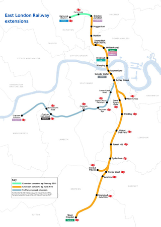
The East London line extension (ELLX) project was a British railway engineering project in London, managed by Transport for London. The project involved extending the East London Line and making it part of the mainline London Overground network. This was done by re-opening sections of disused railway line and by converting track electrified by the third-rail system, signalling, lineside signage and communication systems, etc. to mainline standards. New rolling stock was introduced and four new stations built along the route, with a fifth scheduled to be added in the future at New Bermondsey.

<span class="mw-page-title-main">Crosstown Linkline</span> Railway service in London, England

Crosstown Linkline was a railway service that operated from 14 May 1979 to 11 May 1985 between Camden Road and North Woolwich in London, England. The service was operated by British Rail with financial support from the Greater London Council. It reintroduced passenger trains to sections of line that had not been served for over thirty years. It benefited from several improvements during its brief existence as new stations were added and trains started running on Saturdays in 1983. Operated by diesel trains, it was replaced with the electric North London Link service between Richmond and North Woolwich from 13 May 1985.

References

  1. "Route 6 – North London Line and Thameside: 2009 Route Plan" (PDF). Network Rail. 2009. Archived from the original (PDF) on 7 June 2011. Retrieved 28 May 2009.
  2. 1 2 "London Overground to close from Gospel Oak to Stratford as part of £326m upgrade to deliver longer, more frequent trains". TfL. 18 December 2009. Archived from the original on 25 April 2010. Retrieved 6 February 2010.
  3. 1 2 London Overground: New names for its six lines revealed, BBC News, 15 February 2024
  4. "Memorandum by Inter-Capital and Regional Rail Ltd (RES 4)". Parliamentary Debates (Hansard) . Parliament of the United Kingdom: House of Commons (Select Committee on Environment, Transport and Regional Affairs). 26 January 1999. p. Appendices Section 4.
  5. Transport for London - £36m contract to bring extra rail carriages for London Overground
  6. "Silverlink rises to second position in the national performance league". 18 September 2006. Retrieved 26 October 2007. Association of Train Operating Companies Press Releases
  7. Sharp, Rachel (24 October 2007). "TfL to take on rail network". Ealing Times. Retrieved 26 October 2007.
  8. "Braced for rail strikes". Hackney Gazette. 26 October 2007. Retrieved 26 October 2007.
  9. London Assembly – Light at end of the tunnel for London's forgotten railway
  10. Always Touch Out – London Overground & Orbirail
  11. London's forgotten railway Archived 19 July 2011 at the Wayback Machine (PDF)
  12. Transport for London – East London Railway project
  13. Dalston Junction to Highbury & Islington now Connected
  14. "Naming London Overground lines". Transport for London. Retrieved 11 February 2024.
  15. "London Overground lines to be given unique names". BBC News. 25 August 2023. Retrieved 11 February 2024.
  16. King's Cross Development plan (PDF)
  17. "Sections 17/18 – Section 17 and 18 – new track access contracts : Office of Rail Regulation". Rail-reg.gov.uk. Retrieved 22 June 2010.
  18. "A4" (PDF). Archived from the original (PDF) on 14 April 2010. Retrieved 22 June 2010.
  19. No business case' to divert HS2 via Heathrow, say Mawhinney Page 6-7, Rail Magazine, Issue 649, 28 July to 10 August 2010
  20. Transport Select Committee, 28 June 2011, House of Commons
  21. Laura Reynolds (20 January 2023). "Planning Approval Granted For London's New 'Garden in the Sky'". Londonist . Retrieved 23 January 2023.
  22. Kristine Klein (23 January 2023). "Rails to Trails: London approves planning for the first section of the Camden Highline". The Architect's Newspaper . Retrieved 24 January 2023.
  23. Transport for London Archived 30 March 2010 at the Wayback Machine - Stratford International Extension

Bibliography