Haggerston railway station

Last updated

Haggerston Overground roundel (no text).svg
Haggerston station building April2010.jpg
Station building a day after opening in April 2010
Greater London UK location map 2.svg
Red pog.svg
Haggerston
Location of Haggerston in Greater London
Location Haggerston
Local authority London Borough of Hackney
Managed by London Overground
Owner Transport for London
Station codeHGG
Number of platforms2
AccessibleYes
Fare zone 2
National Rail annual entry and exit
2018–19Increase2.svg 3.539 million [1]
2019–20Decrease2.svg 3.507 million [1]
2020–21Decrease2.svg 0.896 million [1]
2021–22Increase2.svg 2.143 million [1]
2022–23Increase2.svg 3.157 million [1]
Railway companies
Original company North London Railway
Pre-grouping London and North Western Railway
Post-grouping LMS
Key dates
2 September 1867Opened
6 May 1940Closed. After closure, station building bomb damaged 7 October 1940.
27 April 2010Rebuilt and Reopened [2]
Other information
External links
WGS84 51°32′19″N0°04′31″W / 51.5386°N 0.0754°W / 51.5386; -0.0754
Underground sign at Westminster.jpg  London transportportal

Haggerston is a London Overground station in Haggerston, London, England, served by the East London line. It lies between Hoxton and Dalston Junction stations, is in Travelcard Zone 2, and is open 24 hours on a Friday and Saturday as part of the London Overground Night Service service. The station was rebuilt as part of the East London line extension.

Contents

The station is located on the Kingsland Viaduct at the junction of Arbutus Street and Frederick Terrace, near Kingsland Road. The main entrance is in Lee Street. [3]

History

Early history (1867-1923)

When the East & West India Docks & Birmingham Junction Railway (known as the North London Railway (NLR) from 1853) started operating on 26 September 1850, they shared a London terminus at Fenchurch Street railway station with the London and Blackwall Railway which involved a circuitous route via Hackney, Bow and East Stepney for city bound passengers. An act of parliament saw the NLR apply to build a two-mile extension from Dalston to a new London terminus at Broad Street railway station. This was passed in 1861.

The original railway had three tracks and the station had three platform faces. It was situated on a viaduct and was a flat roofed square two storey station building located on Lee Street. Connor suggests the ticket office was at street level and stairs took you up to platform level which were accommodated within the building. The station, which was originally going to be named De-Beauvoir Town was opened on 2 September 1867. [4] It is not known at this juncture whether there were offices or platform level passenger facilities on the top floor of the building. The island platform was accessed by a subway and steps. [5]

A fourth track which did not have a platform face was added in 1872 and used by goods trains to and from Broad Street goods depots. [6]

The signal box was located north of the station between the two sets of running lines.

The London & North Western Railway (LNWR) took over the working of the North London Railway under a common management arrangement on 1 February 1909 although the North London Railway continued to exist until 1922. [7]

In 1916 the two westerly lines were electrified for Broad Street to Richmond services and the two sets of running lines were known as No. 2 Electrics (west side of viaduct) and No 1 Steam (east side of the viaduct). The electric services did not call at Haggerston as there was no fourth platform provided. [8]

Services

It was initially served by local services from Broad Street to Poplar (East India Road) on the City Extension of the North London Railway. Later Great Northern Railway services to New Barnet, Alexandra Palace, High Barnet and Gordon Hill called during the peak hours. Between 1870 and 1890 some Poplar trains were extended to/from Blackwall.

London Midland & Scottish Railway (1923-1940)

Following the Railways Act 1921, also known as the grouping act, operation of the station fall under the control of the London Midland & Scottish Railway.

Sunday services to Poplar were withdrawn on 29 January 1940. [9] Following that, services were withdrawn on 6 May 1940 as an economy measure during World War II and the following October the station building was badly damaged by enemy bombs. [6] The signal box was damaged by a further raid in April 1941 and was not replaced.

After closure (1940-2010)

The Poplar service continued to pass through Haggerston but this was withdrawn on 15 May 1944 due to bomb damage between Dalston and Poplar and declining passenger numbers. [5]

The station building was demolished in December 1946.

The "Steam" lines (also known as No 1 lines) were lifted sometime during the 1970s and traffic declined at Broad Street until that station was closed on 30 June 1986 with the former No 2 electric lines being lifted soon after. [10] After that the trackbed through the station remained overgrown and unused.

The new station (2010-present day)

The East London line extension saw proposals to extend the East London Line (then New Cross/New Cross Gate - Shoreditch) to Dalston and a connection with the North London Line. This scheme involved using the old Broad Street lines and a new station was proposed at Haggerston north of the original site.

The new station was designed by Acanthus LW Architects. [3] The design features towers that serve to strengthen the station's urban presence and recall the language of London's stations of the 1930s designed by Charles Holden. The building is clad externally in precast concrete with screens of cast glass planks. Internally, the building features orange mosaic tiling and a large mural to Edmond Halley, who was born in the area.

Station platforms Haggerston Station - geograph.org.uk - 1938512.jpg
Station platforms

The station was opened to the general public on 27 April 2010 with a limited service running between Dalston Junction and New Cross or New Cross Gate. On 23 May 2010 services were extended from New Cross Gate to West Croydon or Crystal Palace, whilst through trains to Clapham Junction began operating at the December 2012 timetable change.

The former up platform remains (as of 2018) but the original island platform was removed during construction.

Services (2012)

Services are provided by London Overground. As of December 2012 the off-peak service is: [11]

Connections

London Buses routes 149, 242, 243 and night route N242 serve the station. [12]

Line

Preceding station Overground notextroundel.svg National Rail logo.svg London Overground Following station
Dalston Junction East London line Hoxton
Historical railways
Dalston Junction
Line and station open
  London and North Western Railway
North London Railway
  Shoreditch
Line open, station closed

Related Research Articles

<span class="mw-page-title-main">East London line</span> London Overground line

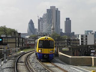
The East London line is part of the London Overground, running north to south through the East, Docklands and South areas of London. It was previously a line of the London Underground.

<span class="mw-page-title-main">North London line</span> Railway line in London

The North London line (NLL) is a railway line which passes through the inner suburbs of west, north-west, north, and north-east London, England between Richmond in the south-west and Stratford in the east, avoiding central London. Its route is a rough semicircle.

<span class="mw-page-title-main">Shadwell railway station</span> London Overground station

Shadwell is a London Overground station in Shadwell in East London. It was formerly a London Underground station on the East London line until 2007. The station is between Whitechapel to the north and Wapping to the south. It is located near to Shadwell DLR station. The station is in Travelcard Zone 2.

<span class="mw-page-title-main">Rotherhithe railway station</span> London Overground station

Rotherhithe is a station on the East London Line located on the southern bank of the River Thames at Rotherhithe within the London Borough of Southwark, Greater London and is served by London Overground services. The station is between Wapping and Canada Water, and is in fare zone 2. The station re-opened for a preview service on 27 April 2010 to New Cross / New Cross Gate and 23 May 2010 for full service to New Cross / West Croydon / Crystal Palace. On 9 December 2012, the line was extended to serve Clapham Junction via Peckham Rye.

<span class="mw-page-title-main">Surrey Quays railway station</span> London Overground station

Surrey Quays is a station on the East London Line of the London Overground. It is located in Rotherhithe, part of London Borough of Southwark; it is in Zone 2. The next station to the north is Canada Water; to the south, it splits into branches to Clapham Junction, New Cross and Crystal Palace/West Croydon. Closed in late 2007 as an underground station, it was refurbished and reopened as part of the London Overground network on 27 April 2010.

<span class="mw-page-title-main">Clapham High Street railway station</span> London Overground station

Clapham High Street railway station is on the South London line in Clapham, within the London Borough of Lambeth, Greater London. It is 6 miles 21 chains (10.1 km) measured from London Bridge. It is served by London Overground services between Clapham Junction and Dalston Junction, with a limited service to Battersea Park. Southeastern services from Lewisham pass through the station, however proposals to call at the station have been limited by the age of Southeastern’s rolling stock.

<span class="mw-page-title-main">Peckham Rye railway station</span> National rail station in London, England

Peckham Rye is a railway station in Peckham town centre, South London. The station is served by Southern, London Overground, Southeastern and Thameslink.

<span class="mw-page-title-main">Queens Road Peckham railway station</span> British railway station

Queens Road Peckham railway station is in the London Borough of Southwark and also serves the area to the east of Peckham, in the London Borough of Lewisham. It is on the South London Line, 2 miles 58 chains (4.4 km) from London Bridge, and trains also go to Croydon via various routes and beyond. It is on the road of that name and is in Travelcard Zone 2.

The North London Railway (NLR) company had lines connecting the northern suburbs of London with the East and West India Docks further east. The main east to west route is now part of London Overground's North London Line. Other NLR lines fell into disuse but were later revived as part of the Docklands Light Railway, and London Overground's East London Line. The company was originally called the East & West India Docks & Birmingham Junction Railway (E&WID&BJR) from its start in 1850, until 1853. In 1909, it entered into an agreement with the London and North Western Railway which introduced common management, and the NLR was taken over completely by the LNWR in 1922. The LNWR itself became part of the LMS from the start of 1923. The railways were nationalised in 1948 and most LMS lines, including the North London route, then came under the control of the London Midland Region of British Railways.

<span class="mw-page-title-main">Honor Oak Park railway station</span> National rail station in London, England

Honor Oak Park railway station serves the suburban area of Honor Oak in the London Borough of Lewisham. It is 4 miles 59 chains down the line from London Bridge, between Brockley and Forest Hill.

<span class="mw-page-title-main">Shoreditch railway station</span> Former railway station in England

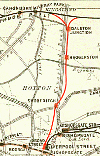
Shoreditch was a railway station on the North London Railway (NLR) in Shoreditch, London, that was in use from 1865 to 1940. It was situated on a viaduct between Haggerston and Broad Street stations. It should not be confused with Shoreditch Underground station (1869–2006) on the London Underground, situated about half a mile further south. It was also not the first main line railway station to possess the Shoreditch name; Bishopsgate (1840–1875) was originally given that name.

<span class="mw-page-title-main">Hackney Central railway station</span> London Overground station

Hackney Central is a London Overground station on the North London line in Hackney Central, north-east London. It lies between Dalston Kingsland and Homerton and is in Travelcard Zone 2. The station and all trains serving it are operated by London Overground services which are managed by Transport for London. However, there is no standard red National Rail "double arrow" logo signage at the station, instead only the Overground roundel.

<span class="mw-page-title-main">Sydenham railway station (London)</span> National rail station in London, England

Sydenham is a railway station in Sydenham in the London Borough of Lewisham, South London. Originally opened in 1839, the station is located on the former Croydon Canal, which is now a branch of the Brighton Main Line, often known as the Sydenham Corridor. Sydenham falls within Travelcard Zone 3 and is served by London Overground and Southern. The station is 6 miles 32 chains down the line from London Bridge.

<span class="mw-page-title-main">Dalston Junction railway station</span> Railway station in London, England

Dalston Junction is an inter-modal rail and bus transport interchange in Dalston, London. It is located at the crossroads of Dalston Lane, Kingsland Road and Balls Pond Road. The station served by London Overground East London line and is in Zone 2. The station is located in a short section of cut and cover tunnel north of the Kingsland Viaduct.

<span class="mw-page-title-main">Shoreditch High Street railway station</span> London Overground station

Shoreditch High Street is a London Overground station located on Bethnal Green Road in Shoreditch in East London. It is served by the East London Line between Whitechapel and Hoxton with services running either to Dalston Junction, Highbury & Islington or New Cross, New Cross Gate, West Croydon, Crystal Palace, and is in Travelcard Zone 1.

<span class="mw-page-title-main">Hoxton railway station</span> London Overground station

Hoxton is a station on the East London line in the London Borough of Hackney, Greater London. It is on the Kingsland Viaduct and served by London Overground. The station entrance is on Geffrye Street near Dunloe Street and Cremer Street, behind the Museum of the Home.

The Cross London Route Utilisation Strategy (CLRUS) was the second of the route utilisation strategies (RUS) published by Network Rail (NR), in August 2006. It was included in a map published by the Office of Rail Regulation as established in May 2007.

<span class="mw-page-title-main">East London line extension</span> Railway engineering project in London

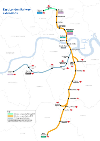
The East London line extension (ELLX) project was a British railway engineering project in London, managed by Transport for London. The project involved extending the East London Line and making it part of the mainline London Overground network. This was done by re-opening sections of disused railway line and by converting track electrified by the third-rail system, signalling, lineside signage and communication systems, etc. to mainline standards. New rolling stock was introduced and four new stations built along the route, with a fifth scheduled to be added in the future at New Bermondsey.

Kingsland Viaduct is a railway viaduct about 2 miles (3 km) in length from Shoreditch to Dalston, wholly within the present London Borough of Hackney in east and north-east part of London. It was built in the 1860s, but was disused from 1986 until it was reopened to carry the London Overground in 2010. The viaduct is owned by Transport for London. Since then it has carried East London Line services between Shoreditch High Street and Dalston.

<span class="mw-page-title-main">North London Line City Branch</span>

The City Branch was a short spur of the North London Line allowing direct access from the east-west main route of the North London Railway to the terminus at Broad Street in the City of London.

References

  1. 1 2 3 4 5 "Estimates of station usage". Rail statistics. Office of Rail Regulation. Please note: Some methodology may vary year on year.
  2. BBC London:The new East London Line opens to the public. Retrieved 27 April 2010
  3. 1 2 "Projects, Haggeston Station". Acanthus LW Architects. Archived from the original on 3 September 2011. Retrieved 27 April 2010.
  4. Catford, Nick. "Haggerston station". Disused stations. Nick Catford. Retrieved 16 July 2021.
  5. 1 2 Connor, J E (2018). London's disused railway stations - the East End. Capital Transport. pp. 160–161. ISBN   9 781854144331.
  6. 1 2 Mitchell, Vic; Smith, Keith (1997). North London Line. Midhurst UK: Middleton Press. fig. 16. ISBN   1 873793 944.
  7. The National Archives, RAIL 529/32 – NLR Board Minute No 6940 of 14 January 1909
  8. Mitchell, Vic; Smith, Keith (1997). "Historical Background". North London Line. Midhurst UK: Middleton Press. ISBN   1 873793 944.
  9. Borley, H V (1993). The memories and writings of a London railway man. Mold: Railway & Canal Historical Society. pp. 76/77. ISBN   0-901461-16-4.
  10. Connor, J E (2018). London's disused railway stations - the East End. Capital Transport. pp. 157, 159. ISBN   9 781854144331.
  11. "Timetable: Highbury & Islington to West Croydon/Clapham Junction" (PDF). Transport for London. Retrieved 25 February 2013.
  12. "Haggerston Station". TfL. Retrieved 17 May 2020.