Barley, Hertfordshire

Last updated

Barley
St Margaret of Antioch, Barley, Hertfordshire - geograph.org.uk - 362626.jpg
St Margaret of Antioch, Barley
Hertfordshire UK location map.svg
Red pog.svg
Barley
Location within Hertfordshire
Population659  [1]
662 (2011 Census) [2]
OS grid reference TL400385
District
Shire county
Region
Country England
Sovereign state United Kingdom
Post town ROYSTON
Postcode district SG8
Dialling code 01763
Police Hertfordshire
Fire Hertfordshire
Ambulance East of England
UK Parliament
List of places
UK
England
Hertfordshire
52°01′38″N0°02′29″E / 52.0272°N 0.0415°E / 52.0272; 0.0415

Barley is a village and civil parish in the district of North Hertfordshire, England. According to the 2001 census, it has a population of 659, [1] increasing to 662 at the 2011 Census. [2] The place-name refers to a lea or meadow and not to the grain-producing plant. Coincidentally to the southwest lies the village of Reed. The Prime Meridian passes to the west of Barley, which is located on the Royston to Saffron Walden road, as well as the medieval London to Cambridge road. [3]

Contents

Buildings

Church

Barley has a church with a 12th-century Norman tower, which is dedicated to St Margaret of Antioch. [4] The church fell into a poor state of repair and was rebuilt in 1872 using designs by William Butterfield. Only the tower and three bays of the south arcade were retained from the original building. [5] [6]

Fox and Hounds

The Fox and Hounds with its distinctive sign The Fox and Hounds Pub - Barley, Hertfordshire - geograph.org.uk - 139202.jpg
The Fox and Hounds with its distinctive sign

A well-known landmark in the village is the sign of the "Fox and Hounds" public house. On top of a beam are painted silhouette figures of huntsmen and hounds chasing a fox into the gable of the public houses at the top of Church End. Although it is a long-established feature of the village, the sign has not always been at its present site. [7] In 1955 the Fox and Hounds, with its famous sign, was a pub located in the High Street, at the time part of an important route to London. In 1955 the Fox & Hounds burned down in a disastrous fire. The sign, which was partially saved, moved to its present site and the existing pub (the Wagon and Horses) was renamed. The pub and its sign are Grade II listed.

There are now two pubs in the village - the other being the Chequers.

Other buildings

The village also includes a 17th-century lock-up [4] and an early Tudor town house with a large timbered upper room, which was mentioned by Daniel Defoe in a travel book in 1726.

A local eccentricity is to embed objects into the flint walls. The Manor has a row of dentures set into its flint wall at one point and a cherub at another, while one of the newer houses in the village has a small figure of the Buddha set into its wall.[ citation needed ]

History

The area has been home to residents for perhaps 3000 years; evidence has been found of Bronze Age settlers in the hills around Royston and Iron Age farmers to the north of the village in 100 BC, and Romans again occupied the parish. [4]

Listed in the Domesday Book as Berlei, the name Barley derived not from the local crop but from Beora's Ley, the woodland clearing of a Saxon Lord. [4]

Facilities

Barley is home to Barley Church of England V.C. First School.

Governance

Barley has three tiers of local government at parish, district and county level: Barley Parish Council, North Hertfordshire District Council, and Hertfordshire County Council.

Barley is an ancient parish, and it was part of the hundred of Edwinstree. Barley was included in the Royston Poor Law Union from 1835. [8] The Local Government Act 1894 created parish and district councils. The parish of Barley was included in Ashwell Rural District from 28 December 1894, and Barley Parish Council came into being on 31 December 1894, taking over the secular functions of the parish vestry. Despite the name, Ashwell Rural District Council was based in the town of Royston. Ashwell Rural District was abolished in 1935, becoming part of Hitchin Rural District, which in turn was abolished in 1974, becoming part of North Hertfordshire. [9]

Notable residents

Notable historical residents include William Warham, [10] Redcliffe and Nina Salaman, Rev Charles Oswald Miles, Curate from 1882-5 and Thomas Willett, future Mayor of New York. His house Willet's Cottage was demolished in 1972. [11] Sam Smith worked in the local shop before the height of their fame. The actor Jaye Griffiths also lives in the village.

See also

Related Research Articles

<span class="mw-page-title-main">Royston, Hertfordshire</span> Town in Hertfordshire, England

Royston is a town and civil parish in the District of North Hertfordshire and county of Hertfordshire in England.

<span class="mw-page-title-main">Baldock</span> Town in Hertfordshire, England

Baldock is a historic market town in the North Hertfordshire district of Hertfordshire, England. The River Ivel rises from springs in the town. It lies 33 miles (53 km) north of London and 14 miles (23 km) north northwest of the county town of Hertford. Nearby towns include Royston to the northeast, Letchworth and Hitchin to the southwest and Stevenage to the south.

<span class="mw-page-title-main">Willian, Hertfordshire</span> Human settlement in England

Willian is a village and former civil parish, adjoining the town of Letchworth, in the North Hertfordshire district of Hertfordshire, England. Along with Norton and Old Letchworth, it is one of the original three villages around which the garden city of Letchworth Garden City was created. Despite this, the village retains a separate character to the rest of Letchworth Garden City. In 1931 the parish had a population of 210.

<span class="mw-page-title-main">Hinxworth</span> Human settlement in England

Hinxworth is a village and civil parish in North Hertfordshire, England. It sits just off the Great North Road between Baldock and Biggleswade. It has a village hall, a park, a pub, a small church, a bus stop and a post box. The population at the 2011 Census was 313.

<span class="mw-page-title-main">Melbourn</span> Village in England

Melbourn is a large, clustered village in the far south-west of Cambridgeshire, England. Its traditional high street is bypassed by the A10, intersecting the settlement's other main axis exactly 3 miles (4.8 km) northwest of the traditional focal point of Royston, Hertfordshire, the nearest larger settlement. It has over 4,600 inhabitants and is in the South Cambridgeshire district.

<span class="mw-page-title-main">Therfield</span> Human settlement in England

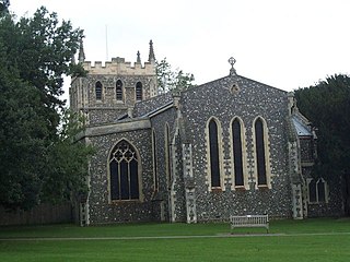
Therfield is both a small village of approximately 4,761 acres (19 km²) and a civil parish which sits upon the chalk range, three miles southwest of Royston, and six miles (10 km) northeast of Baldock and within the English county of Hertfordshire.

<span class="mw-page-title-main">Graveley, Hertfordshire</span> Human settlement in England

Graveley is a village and civil parish about four miles east of Hitchin and two miles north of Stevenage in Hertfordshire, England. The population of the parish in the 2011 census was 487. A milestone in the village states that it is 33 miles from London.

<span class="mw-page-title-main">Ashwell, Hertfordshire</span> Human settlement in England

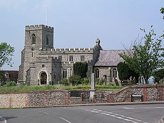
Ashwell is a village and civil parish in Hertfordshire situated 4 miles (6 km) north-east of Baldock.

<span class="mw-page-title-main">The Rodings</span>

The Rodings are a group of eight villages in the upper part of the River Roding and the west of Essex, England, the largest group in the country to bear a common name. The Rodings do not lie within a single district in the county; they are arranged around the tripoint of the administrative areas of Chelmsford, Uttlesford and Epping Forest. An alternative arcane name, linked to the Middle English Essex dialect, was The Roothings.

<span class="mw-page-title-main">Barkway</span> Human settlement in England

Barkway is a long-established village and civil parish in the North Hertfordshire district of Hertfordshire, England, about five miles south-east of Royston, 35 miles from London and 15 miles from the centre of Cambridge. The Prime Meridian passes a mile or so to the west of Barkway.

Bassingbourn cum Kneesworth is a civil parish in the South Cambridgeshire district of Cambridgeshire, England, 14 miles south-west of Cambridge and just north of Royston, Hertfordshire. Since the 1960s the parish contains the villages of Bassingbourn and Kneesworth.

<span class="mw-page-title-main">Melbourn Rural District</span> History of Cambridgeshire

Melbourn Rural District was a rural district in Cambridgeshire, England, from 1894 to 1934.

<span class="mw-page-title-main">Kelshall</span> Human settlement in England

Kelshall is a small village in North East Hertfordshire, England. It is near the town of Royston. It has a village hall and the local church is St Faith's. Kelshall is also the name of the civil parish. Kelshall also has a major road running along one of its boundaries. In the 1880s the church was described as being "ancient, plain, and good, with a tower; and contains a few brasses and monuments".

Nuthampstead is a small village and civil parish in North East Hertfordshire located a few miles south of the town of Royston. In the 2001 census the parish had 139 residents, increasing to 142 at the 2011 Census.

<span class="mw-page-title-main">Reed, Hertfordshire</span> Human settlement in England

Reed is a small village and civil parish in North Hertfordshire. It is situated on a chalk ridge, approximately 3 miles (4.8 km) south of the market town of Royston. The Prime Meridian passes just to the east of the village, between Reed and Barkway. The modern A10 road passes just to the west of the village. The population of the parish was 310 at the time of the 2011 census.

<span class="mw-page-title-main">Steeple Morden</span> Human settlement in England

Steeple Morden is a village and civil parish in Cambridgeshire, England, about 15 miles (24 km) south west of Cambridge and 5 miles (8 km) west of Royston. It is part of the South Cambridgeshire local government district.

Hitchin Rural District was a rural district in Hertfordshire, England from 1894 to 1974, covering an area in the north of the county.

<span class="mw-page-title-main">Great Chishill</span> Village in England

Great Chishill is a village and former civil parish, now in the parish of Great and Little Chishill, in the South Cambridgeshire district, in the county of Cambridgeshire, England. The village is about 1 mile (1.6 km) east of the county boundary with Hertfordshire and about 4 miles (6 km) east of Royston. In 1961 the parish had a population of 293. The 2011 Census recorded Great and Little Chishill's population as 678.

<span class="mw-page-title-main">Margaret Roding</span> Human settlement in England

Margaret Roding is a village and civil parish in the Uttlesford district of Essex, England. The village is included in the eight hamlets and villages called The Rodings. Margaret Roding is 7 miles (11 km) north-west from the county town of Chelmsford.

Ashwell Rural District was a rural district in Hertfordshire, England from 1894 to 1935, covering an area in the north-east of the county.

References

  1. 1 2 2001 Census
  2. 1 2 "Civil Parish population 2011". Neighbourhood Statistics. Office for National Statistics. Retrieved 26 October 2016.
  3. "Milestone". milestones.megalithia.com.
  4. 1 2 3 4 "Village". Barley.
  5. "Church of St Margaret of Antioch".
  6. Comprehensive Gazetteer of England and Wales. 1895.
  7. "Barley".
  8. Higginbotham, Peter. "Royston Poor Law Union". The Workhouse. Retrieved 11 December 2021.
  9. "Barley Civil Parish / Ancient Parish". A Vision of Britain through Time. GB Historical GIS / University of Portsmouth. Retrieved 11 December 2021.
  10. "William Warham entry in Britannia". Archived from the original on 8 June 2007. Retrieved 19 July 2007.
  11. St Margaret of Antioch, Barley