Baldock is a historic market town in the North Hertfordshire district of Hertfordshire, England. The River Ivel rises from springs in the town. It lies 33 miles (53 km) north of London and 14 miles (23 km) north northwest of the county town of Hertford. Nearby towns include Royston to the northeast, Letchworth and Hitchin to the southwest and Stevenage to the south.
Norton is a small village and former civil parish in Hertfordshire, England, one of the three original villages which were absorbed into Letchworth Garden City, the other two being Willian and Old Letchworth. The village is known to have existed by 1007, with remains of the medieval settlement visible as earthworks in a field beside the church. However, the history of the village goes back even further than that. In 1901 the parish had a population of 169.

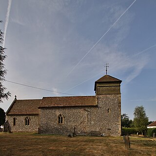
Hinxworth is a village and civil parish in North Hertfordshire, England. It sits just off the Great North Road between Baldock and Biggleswade. It has a village hall, a park, a pub, a small church, a bus stop and a post box. The population at the 2011 Census was 313.

Blidworth is a village and civil parish approximately five miles east of Mansfield, Nottinghamshire, England. The population of the civil parish at the 2011 census was 4,457, this dropped to 4,295 in the 2021 census. Its history can be traced back to the 10th century, although many of the current houses were built in the first half of the 20th century to provide housing for workers at Blidworth Colliery (1926–1989). These are mainly in estates north of Dale Lane, known as New Blidworth. The area around Main Street, west of Beck Lane and including the church, is Old Blidworth, containing some of the oldest buildings. Blidworth Bottoms is a hamlet about 0.5 km south of Old Blidworth, while Haywood Oaks is the portion of the village south of Dale Lane and the south eastern rural area of the parish surrounding Haywood Oaks Lane.

West Lulworth is a village and civil parish in the English county of Dorset, situated on the English Channel beside Lulworth Cove. In the 2011 census the civil parish—which includes most of Lulworth Camp army base—had 291 households and a population of 714. The village is a gateway to the Jurassic Coast World Heritage Site and is a popular tourist destination, especially for day trips.

Chrishall is a small village and civil parish in the Uttlesford district of Essex, England. The village lies close to the borders with Cambridgeshire and Hertfordshire, 12 miles (20 km) south of Cambridge and equidistant [6 miles (10 km)] between the two medieval market towns of Saffron Walden and Royston.

St Ippolyts is a village and civil parish on the southern edge of Hitchin in Hertfordshire, England. It has a population of approximately 2,000.

Bosbury is a village and civil parish in Herefordshire, England, approximately 3.5 miles (5.6 km) north of Ledbury. The small River Leadon flows through the parish, passing along the west side of the village. Bosbury shares a parish council with neighbouring Coddington.

In folklore, Jack o' Legs is a giant from Hertfordshire, England. Jack is said to have been an archer who, like Robin Hood, robbed the rich to give to the poor. His supposed grave is in the churchyard of Holy Trinity Church, Weston.

Hertford Heath is a village and civil parish near the county town of Hertford in Hertfordshire, England. The population at the 2011 Census was 2,672.
Great Amwell is a village and civil parish in the East Hertfordshire district, in the county of Hertfordshire, England. It is 1+1⁄2 miles (2.4 km) southeast of Ware and about 20 miles (32 km) north of London. In 2011 the parish had a population of 2353.

Caldecote is a village and civil parish in the North Hertfordshire district of Hertfordshire, England. It is located around three miles north of Baldock and around a mile and a half east of Stotfold in the neighbouring county of Bedfordshire. The Great North Road passes just to the west of the village.
Nuffield is a village and civil parish in the Chiltern Hills in South Oxfordshire, England, just over 4 miles (6 km) east of Wallingford. The 2011 Census recorded the parish population as 939.

Wallington is a small village and civil parish in the North Hertfordshire district, in the county of Hertfordshire, England, near the town of Baldock. The population of the civil parish at the 2011 Census was 150. Nearby villages include Rushden and Sandon. It shares a parish council with Rushden.

Hertingfordbury is a small village in Hertfordshire, England, close to the county town of Hertford. It was mentioned in the Domesday Book of 1086. Hertingfordbury is also the name of a neighbouring civil parish, which does not contain the village. Hertingfordbury village is within the Castle ward of local government Hertford Town Council. The population of the civil parish as of the 2021 census was 689.

Little Berkhamsted is a village and civil parish in Hertfordshire, England, five miles south-west of the town of Hertford.

Clothall is a village and civil parish in the county of Hertfordshire, England, with a population of 358. It is situated 2.25 miles (3.62 km) south-east of Baldock, and is in the district of North Hertfordshire. At the 2011 Census the civil parish had a population of 150. The village contains the Church of St Mary the Virgin, which was built of flint and stone around 1350–70, though parts of the church are older, dating to the 12th century.

Sandon is a village and civil parish in the North Hertfordshire district, in the county of Hertfordshire, England. Sandon is located near the towns of Baldock and Buntingford. The parish also includes the hamlets of Green End and Roe Green, and Blagrove Common, a nature reserve. At the 2011 Census the population of the civil parish was 495.

Weston is a village and civil parish in the South Holland district of Lincolnshire, England. It is situated approximately 2 miles (3 km) north-east from the town of Spalding. The Civil Parish also includes Weston Hills. The population of the civil parish including Austendike was at the 2011 census 2,054.

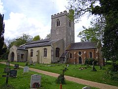
Holy Trinity Church is the parish church for the village of Weston in Hertfordshire. The church building stands to the south-east of the village on high ground, and is built of flint and coursed ironstone rubble. It was Grade I listed in 1968. In the churchyard is the supposed grave of the giant Jack o'Legs.