Related Research Articles

Seven Fields is a borough in Butler County, Pennsylvania, United States. The population was 2,887 at the 2010 census, an increase from the figure of 1,986 tabulated in 2000.
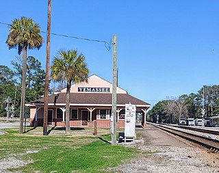
Yemassee is a small Lowcountry town in Beaufort and Hampton counties in the U.S. state of South Carolina. The population was 1,027 at the 2010 census. Yemassee is near the borders of Colleton and Jasper counties. The town is divided by the county line between Beaufort and Hampton counties, which follows the roadbed of the CSX railroad. Most of the town's population presently lies within Hampton County. As defined by the U.S. Census Bureau, the Beaufort County portion of Yemassee is included within the Hilton Head Island-Bluffton-Beaufort, SC Metropolitan Statistical Area. Yemassee hosts one of the few commercial breeding facilities of non-human primates in the entire United States, Alpha Genesis, Inc., which serves as a major employer for the town. Also, the Frank Lloyd Wright-designed Auldbrass Plantation house and outbuildings lie just outside the town limits of Yemassee.

Fort Mitchell National Cemetery is one of the 130 United States National Cemeteries, located in Fort Mitchell, Alabama, adjacent to the state-owned and operated Fort Mitchell Park. It has interred approximately 5,000 individual since it officially opened its 280-acre (110 ha) site in 1987. It serves as a national cemetery in Federal Region IV, to serve veterans residing in North Carolina, South Carolina, Georgia, Florida, Alabama, Tennessee, and Mississippi.
Ashepoo River is a short blackwater river in South Carolina, United States. It rises in a confluence of swamps south of Walterboro, flows in a southeast direction and empties into Saint Helena Sound at 32.49°N 80.42389°W. The entire course of the river lies within the boundaries of Colleton County.
The Salkehatchie River originates near the City of Barnwell, South Carolina and accepts drainage from Turkey Creek and Whippy Swamp before merging with the Little Salkehatchie River to form the Combahee River Basin, which empties into Saint Helena Sound and the Atlantic Ocean. Prior to the confluence, the Little Salkehatchie River accepts drainage from Lemon Creek, Buckhead Creek, and Willow Swamp.
WYKZ is an adult contemporary radio station owned by iHeartMedia, Inc. and licensed to Beaufort, South Carolina, with the branding "98.7 The River - The Best Variety Of Yesterday & Today!" The station's studio is located on Alfred St. in Savannah, Georgia, and the transmitter is located near Sun City, South Carolina.
WSLW is a broadcast radio station licensed to White Sulphur Springs, West Virginia, serving White Sulphur Springs and Lewisburg in West Virginia. WSLW is owned by Todd P. Robinson.

Round O is an unincorporated community in Colleton County, South Carolina, United States. The population of Round O is 2,136 people. Its elevation is 36 feet (11 m). It is located near the intersection of Cottageville Highway and Round O Road.
Sioux National Forest was a National Forest (NF) established by Executive Order 908 on July 1, 1908. The order called for the consolidation of the following national forests and forest units into a single entity:
Selbysport is an unincorporated community in Garrett County, Maryland, United States. Mercy Chapel at Mill Run was listed on the National Register of Historic Places in 1984.
Barrelville is an unincorporated community and census-designated place (CDP) in Allegany County, Maryland, United States. As of the 2010 census, it had a population of 73. It is located between Corriganville and Mount Savage, where an 1804 road from Pennsylvania intersected the legendary Turkey Foot Road. Jennings Run flows from Mount Savage to Barrelville, where another tributary that runs south from Wellersburg, Pennsylvania, joins Jennings Run.
Harbor Island is a small residential island located 14 miles (22 km) east of Beaufort, South Carolina. It is one of the Carolina Sea Islands. The swing drawbridge has been replaced by a fixed high level bridge. , Harbor River Bridge, that connects the island to Saint Helena Island towards the west. A small causeway crossing Johnson Creek connects Harbor Island with Hunting Island towards the south.
Simons Corner is an unincorporated community in Richmond County, in the U.S. state of Virginia.
Old Fitzhugh is an unincorporated community located in Brunswick County, in the U.S. state of Virginia.
Sherman is a ghost town in Albany County, Wyoming, United States. Sherman is 19 miles (31 km) southeast of Laramie in the Laramie Mountains and is named for Civil War general William Tecumseh Sherman, purportedly at his request. From the 1860s to 1918, the town sat at the summit of the original grade of the first transcontinental railroad along the rails of the Union Pacific Railroad, at an elevation of 8,247 ft (2,514 m).
Melham is an unincorporated community in Clark County, in the U.S. state of South Dakota.
Vestal Springs is an unincorporated community in Custer County, in the U.S. state of South Dakota.
Rhyse is an unincorporated community in Dent County, in the U.S. state of Missouri.
Greenlawn is an unincorporated community in Ralls County, in the U.S. state of Missouri.
Grahamville is an unincorporated community in Jasper County, in the U.S. state of South Carolina.
References
- ↑ U.S. Geological Survey Geographic Names Information System: Barrelville, South Carolina
- ↑ Federal Writers' Project (1941). Palmetto Place Names. Sloane Printing Co. p. 22.
Municipalities and communities of Charleston County, South Carolina, United States | ||
|---|---|---|
| Cities |  | |
| Towns | ||
| CDPs | ||
| Other communities | ||
| Ghost town | ||
| Footnotes | ‡This populated place also has portions in an adjacent county or counties | |
Coordinates: 32°41′11″N80°21′03″W / 32.68639°N 80.35083°W
| | This South Carolina state location article is a stub. You can help Wikipedia by expanding it. |