Meggett, South Carolina

Last updated

Meggett, South Carolina
Meggett SC.jpg
South Carolina Produce Associate Building in Meggett, SC
SCMap-doton-Hollywood.PNG
Location of Meggett in South Carolina
Coordinates: 32°42′20″N80°15′47″W / 32.70556°N 80.26306°W / 32.70556; -80.26306
Country United States
State South Carolina
County Charleston
Government
   Mayor Harry V. "Buster" Herrington III
Area
[1]
  Total18.76 sq mi (48.59 km2)
  Land18.14 sq mi (46.99 km2)
  Water0.62 sq mi (1.61 km2)
Elevation
10 ft (3 m)
Population
 (2020) [2]
  Total1,390
  Density76.62/sq mi (29.58/km2)
Time zone UTC-5 (EST)
  Summer (DST) UTC-4 (EDT)
ZIP code
29449
Area code(s) 843, 854
FIPS code 45-45790 [3]
GNIS feature ID1231537 [4]
Website www.townofmeggettsc.org

Meggett is a town in Charleston County, South Carolina, United States. The population was 1,226 at the 2010 census. [5] Meggett is part of the Charleston-North Charleston-Summerville metropolitan area.

Contents

History

The Towles Farmstead was listed on the National Register of Historic Places in 1994. [6]

Geography

Meggett is located in southwestern Charleston County at 32°42′20″N80°15′47″W / 32.70556°N 80.26306°W / 32.70556; -80.26306 (32.705515, -80.263106). [7] It is bordered to the north by the town of Hollywood. The traditional center of Meggett is along South Carolina Highway 165, 1.5 miles (2.4 km) south of the center of Hollywood and 2.5 miles (4.0 km) north of the highway's end at Yonges Island. The Meggett town limits have expanded east as far as the Stono River and west beyond Toogoodoo Creek as far as South Carolina Highway 174. To the south the town extends as far as Yonges Island next to the Wadmalaw River.

According to the United States Census Bureau, Meggett has a total area of 18.4 square miles (47.7 km2), of which 17.8 square miles (46.2 km2) is land and 0.58 square miles (1.5 km2), or 3.11%, is water. [5] The town area has increased from a total of 14.8 square miles (38.4 km2) in 2000.

Demographics

Historical population
CensusPop.Note
1950 224
1960 188−16.1%
1970 180−4.3%
1980 24938.3%
1990 787216.1%
2000 1,23056.3%
2010 1,226−0.3%
2020 1,39013.4%
U.S. Decennial Census [8] [2]

2020 census

Meggett racial composition [9]
RaceNum.Perc.
White (non-Hispanic)1,20086.33%
Black or African American (non-Hispanic)1128.06%
Native American 20.14%
Asian 100.72%
Other/Mixed 332.37%
Hispanic or Latino 332.37%

As of the 2020 United States census, there were 1,390 people, 498 households, and 325 families residing in the town.

2000 census

As of the census [3] of 2000, there were 1,230 people, 484 households, and 377 families residing in the town. The population density was 84.4 inhabitants per square mile (32.6/km2). There were 540 housing units at an average density of 37.1 per square mile (14.3/km2). The racial makeup of the town was 78.78% White, 20.24% African American, 0.41% Native American, 0.08% Asian, and 0.49% from two or more races. Hispanic or Latino of any race were 0.57% of the population.

There were 484 households, out of which 28.3% had children under the age of 18 living with them, 67.8% were married couples living together, 6.8% had a female householder with no husband present, and 22.1% were non-families. 18.8% of all households were made up of individuals, and 8.5% had someone living alone who was 65 years of age or older. The average household size was 2.54 and the average family size was 2.90.

In the town, the population was spread out, with 21.5% under the age of 18, 5.9% from 18 to 24, 25.5% from 25 to 44, 33.5% from 45 to 64, and 13.7% who were 65 years of age or older. The median age was 44 years. For every 100 females, there were 105.3 males. For every 100 females age 18 and over, there were 103.8 males.

The median income for a household in the town was $45,809, and the median income for a family was $51,667. Males had a median income of $36,563 versus $26,375 for females. The per capita income for the town was $22,906. About 6.0% of families and 9.3% of the population were below the poverty line, including 10.8% of those under age 18 and 10.7% of those age 65 or over.

Government

The town is run by an elected mayor–council government system. The mayor is Harry V. "Buster" Herrington III, and the council members are Tommy Butler (Mayor Pro Tem), Keith McCarty, Tom Hutto, and Angela Watts.

Related Research Articles

<span class="mw-page-title-main">Kendall West, Florida</span> Census-designated place in Florida

Kendall West is a census-designated place and unincorporated community in Miami-Dade County, Florida, west of the Florida Turnpike. It is located in the Miami metropolitan area of South Florida. The population was 36,536 at the 2020 census.

<span class="mw-page-title-main">Garber, Iowa</span> City in Iowa, United States

Garber is a city in Clayton County, Iowa, United States. The population was 76 at the time of the 2020 census, down from 103 in 2000.

<span class="mw-page-title-main">Charleston, Maine</span> Town in the state of Maine, United States

Charleston is a town in Penobscot County, Maine, United States. It is part of the Bangor Metropolitan Statistical Area. The population was 1,558 at the 2020 census. Charleston includes the village of West Charleston and is home to the Higgins Classical Institute, a Christian school.

<span class="mw-page-title-main">Vining, Minnesota</span> City in Minnesota, United States

Vining is a city in Otter Tail County, Minnesota, United States. The population was 62 at the 2020 census.

<span class="mw-page-title-main">Steen, Minnesota</span> City in Minnesota, United States

Steen is a city in Rock County, Minnesota, United States. The population was 180 at the 2010 census.

<span class="mw-page-title-main">Allendale, South Carolina</span> Town in South Carolina, United States

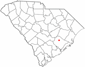
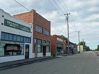
Allendale is a town in and the county seat of Allendale County, South Carolina, United States. The population was 3,482 at the 2010 census, a decline from 4,052 in 2000.

<span class="mw-page-title-main">Bonneau, South Carolina</span> Town in South Carolina, United States

Bonneau is a town in Berkeley County, South Carolina, United States. The population was 487 at the 2010 census. It is part of the Charleston–North Charleston–Summerville Metropolitan Statistical Area.

<span class="mw-page-title-main">Moncks Corner, South Carolina</span> Town in South Carolina, United States

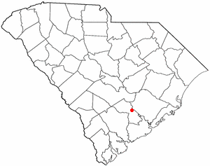
Moncks Corner is a town in and the county seat of Berkeley County, South Carolina, United States. The population was 7,885 at the 2010 census. As defined by the U.S. Census Bureau, Moncks Corner is included within the Charleston-North Charleston, SC Metropolitan Statistical Area.

<span class="mw-page-title-main">St. Stephen, South Carolina</span> Town in South Carolina, United States

St. Stephen is a town in Berkeley County, South Carolina, United States. The population was 1,697 at the 2010 census.

<span class="mw-page-title-main">Awendaw, South Carolina</span> Town in South Carolina, United States

Awendaw is a small fishing town in Charleston County, South Carolina, United States. The population was 1,294 at the 2010 census. Awendaw is part of the Charleston, South Carolina metropolitan area.

<span class="mw-page-title-main">Folly Beach, South Carolina</span> City in South Carolina, United States

Folly Beach is a public city on Folly Island in Charleston County, South Carolina, United States. The population was 2,617 at the 2010 census, up from 2,116 in 2000. Folly Beach is within the Charleston-North Charleston-Summerville metropolitan area and the Charleston-North Charleston Urbanized Areas.

<span class="mw-page-title-main">Hollywood, South Carolina</span> Town in South Carolina, United States

Hollywood is a town in Charleston County, South Carolina, United States. The population was 4,714 at the 2010 census, up from 3,946 in 2000. Hollywood is part of the Charleston, South Carolina metropolitan area and the Charleston-North Charleston Urbanized Area.

<span class="mw-page-title-main">Ravenel, South Carolina</span> Town in South Carolina, United States

Ravenel is a town in Charleston County, South Carolina, United States. The population was 2,465 at the 2010 census. Ravenel is part of the Charleston-North Charleston-Summerville metropolitan area.

<span class="mw-page-title-main">Rockville, South Carolina</span> Town in South Carolina, United States

Rockville is a town in Charleston County, South Carolina, United States, that was founded in 1784. The population was 134 at the 2010 census. Rockville is part of the Charleston-North Charleston-Summerville metropolitan area.

<span class="mw-page-title-main">Seabrook Island, South Carolina</span> Town in South Carolina, United States

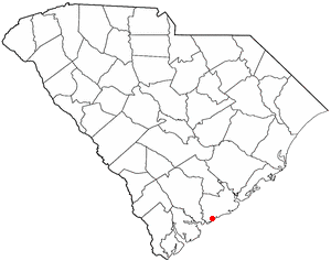
Seabrook Island, formerly known as Simmons Island, is a barrier island in Charleston County, South Carolina, United States. The population was 1,714 at the 2010 census, up from 1,250 in 2000.

<span class="mw-page-title-main">Ridgeville, South Carolina</span> Town in South Carolina, United States

Ridgeville is a town in Dorchester County, South Carolina, United States. The population was 1,979 at the 2010 census, up from 1,690 at the 2000 census. Ridgeville is part of the Charleston-North Charleston-Summerville metropolitan area.

<span class="mw-page-title-main">St. George, South Carolina</span> Town in South Carolina, United States

Saint George is a town in Dorchester County, South Carolina, United States. The population was 2,084 at the 2010 census, eight fewer than in 2000 census. It has been the county seat of Dorchester County since the county was formed from Colleton County in 1897.

<span class="mw-page-title-main">Ridgeland, South Carolina</span> Town in South Carolina, United States

Ridgeland is a town in Jasper and Beaufort counties, South Carolina, United States. The population was 3,749 at the 2020 census, a 7.1% decrease from 2010. It has been the county seat of Jasper County since the county's formation in 1912. As defined by the U.S. Census Bureau, Ridgeland is included within the Hilton Head Island–Bluffton metropolitan area.

<span class="mw-page-title-main">Ladson, South Carolina</span> Census-designated place in South Carolina, United States

Ladson is a census-designated place (CDP) in Berkeley, Charleston and Dorchester counties in the U.S. state of South Carolina. The population was 13,790 at the 2010 census. It is named in honor of the Ladson family, one of the oldest planter and merchant families in the Charleston area; one of its members was lieutenant governor James Ladson.

<span class="mw-page-title-main">Smyrna, South Carolina</span> Town in South Carolina, United States

Smyrna is a small town in York and Cherokee counties in the U.S. state of South Carolina. The population was 45 at the 2010 United States Census,..

References

  1. "ArcGIS REST Services Directory". United States Census Bureau. Retrieved October 15, 2022.
  2. 1 2 "Census Population API". United States Census Bureau. Retrieved October 15, 2022.
  3. 1 2 "U.S. Census website". United States Census Bureau . Retrieved January 31, 2008.
  4. "US Board on Geographic Names". United States Geological Survey. October 25, 2007. Retrieved January 31, 2008.
  5. 1 2 "Geographic Identifiers: 2010 Census Summary File 1 (G001): Meggett town, South Carolina". U.S. Census Bureau, American Factfinder. Archived from the original on February 13, 2020. Retrieved June 29, 2015.
  6. "National Register Information System". National Register of Historic Places . National Park Service. July 9, 2010.
  7. "US Gazetteer files: 2010, 2000, and 1990". United States Census Bureau. February 12, 2011. Retrieved April 23, 2011.
  8. "Census of Population and Housing". Census.gov. Retrieved June 4, 2015.
  9. "Explore Census Data". data.census.gov. Retrieved December 15, 2021.