Bradfield Combust with Stanningfield is a civil parish about 6 miles south of Bury St Edmunds, in the West Suffolk district of Suffolk, England.

Higham is a village and civil parish in the West Suffolk district of Suffolk in the east of England. Located midway between Bury St Edmunds and Newmarket, in 2005 its population was 140. Higham is split into three parts: Upper Green, Middle Green and Lower Green.
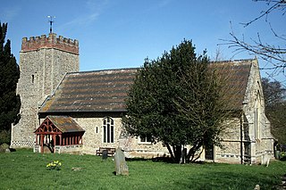
Bradfield St. George is a village and civil parish in the West Suffolk district of Suffolk, England, about 6 miles (9.7 km) south of Bury St Edmunds.
The Saxhams is a civil parish in the West Suffolk district of Suffolk in eastern England. Located around two miles west of Bury St Edmunds, the parish covers the villages of Great Saxham and Little Saxham, as well as the Saxham Industrial Estate on the A14. In 2005 its population was 300. The parish was formed in 1998 from "Great Saxham" and "Little Saxham" and part of Risby.

Denham is a village and civil parish in northern Suffolk. Located approximately 3 miles east of Eye, it is within the district of Mid Suffolk. It shares its name with Denham, another Suffolk village.
Copdock and Washbrook is a civil parish in the Babergh district in the county of Suffolk, England. It covers the villages of Copdock and Washbrook, as well as the hamlets of Coles Green, Mace Green and Washbrook Street.

Wenham Parva is a civil parish in Suffolk, England. It covers the village of Little Wenham and the hamlet of Wenham Grange. Located in Babergh district, it had a population of 20 in 2005, making it the joint-least populated parish in Suffolk alongside South Cove, Wangford and Wordwell. At the 2011 Census the population had increased to 185.

Brampton with Stoven is a civil parish in the East Suffolk district of the English county of Suffolk. It is located 6 miles (9.7 km) south of the town of Beccles and 4 miles (6.4 km) north-east of Halesworth, with an area of 12 square kilometres (4.6 sq mi). The parish was formed in 1987 from the parishes of Brampton and Stoven, and the two villages are the major population centres in the parish, with Brampton the larger centre with almost all of the parishes services. It borders the parishes of Sotterley, Uggeshall, Sotherton, Westhall, Ilketshall St Andrew and Shadingfield.

Rishangles is a village and civil parish in the Mid Suffolk district of Suffolk in eastern England.

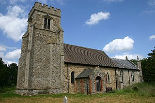
Redlingfield is a village and civil parish in the Mid Suffolk district of Suffolk in eastern England. Located around six miles south-east of Diss, in 2011 its population was 144, according to the 2011 census. Redlingfield Priory was found here from 1120 until it was disbanded during the Dissolution of the Monasteries, in which "the priory was surrendered on 10 February 1536-7".
Depden is a village and civil parish in the West Suffolk district of Suffolk in eastern England. Located on the A143 around five miles south-west of Bury St Edmunds, in 2005 its population was 200, reducing to 184 at the 2011 Census.

Great Whelnetham is a village and civil parish in the West Suffolk district of Suffolk in eastern England. Located around two miles south of Bury St Edmunds, in 2005 its population was 820.

Little Whelnetham (well-NEE-thum) is a village and civil parish in the West Suffolk district of Suffolk in eastern England. Located around two miles south of Bury St Edmunds, in 2005 its population was 180.
Rushbrooke with Rougham is a large civil parish in the West Suffolk district of Suffolk in eastern England covering the villages of Blackthorpe, Rougham and Rushbrooke as well as Rougham Airfield. Located directly south-east of Bury St Edmunds, in 2005 its population was 1,140. One 'Henry of Rushbrook' was Abbot of Bury St Edmunds from 1235 to 1248. The site of a former stately home, Rushbrooke Hall, is situated to the south of Rushbrooke. Until April 2019 it was in the St Edmundsbury district. The parish was created on 1 April 1988 from Rougham and parts of Great Barton, Great Whelnetham and Rushbrooke.
Little Wratting is a small village and civil parish in the West Suffolk district of Suffolk in eastern England. Located on the north-eastern edge of Haverhill, in 2005 its population was 160.

Denham is a village and civil parish in the West Suffolk district of Suffolk in eastern England. Located around five miles west of Bury St Edmunds, in 2005 its population was 170, increasing to 171 at the 2011 Census. The parish also includes the hamlet of Denham End, as well as the remains of Denham Castle, a motte-and-bailey structure. The parish council is shared with neighbouring Barrow.
Chediston is a village and a civil parish on the B1123 road, in the East Suffolk district, in the English county of Suffolk. It is located 2 miles west of Halesworth, its post town. The population of the civil parish as of the 2011 census was 195 and in 2018 it was estimated to be 234.

Purdis Farm is a civil parish, in the East Suffolk district, in the English county of Suffolk. It is located on the eastern edge of Ipswich and includes areas of suburban housing and industrial development along the A1156, including the area of Warren Heath. In 2001 the population of the area was 1743, the population increasing to 2,092 at the 2011 Census.

Southolt is a village and civil parish in Suffolk, about 4+1⁄2 miles (7 km) southeast of Eye, on the road between Bedingfield and Worlingworth.
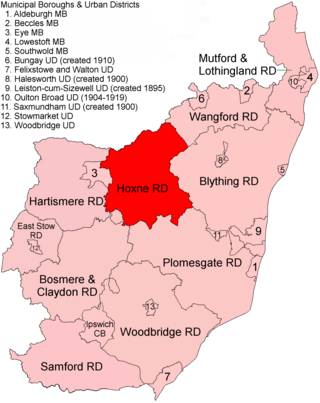
Hoxne Rural District was a rural district within the administrative county of East Suffolk between 1894 and 1934. It was created out of the earlier Hoxne rural sanitary district. It was named after the historic hundred of Hoxne, whose boundaries it closely matched. The hundred, in turn, took its name from the village of Hoxne.

