Beecroft, New South Wales

Last updated

Beecroft
Sydney,  New South Wales
Federation cottage Beecroft 001a.jpg
Suburban home in Beecroft in the Federation style
Beecroft, New South Wales
Population9,396 (2016 census) [1]
 • Density1,842/km2 (4,770/sq mi)
Postcode(s) 2119
Elevation145 m (476 ft)
Area5.1 km2 (2.0 sq mi)
Location22 km (14 mi) north-west of Sydney CBD
LGA(s)
State electorate(s) Epping
Federal division(s)
Suburbs around Beecroft:
West Pennant Hills Pennant Hills Pennant Hills
West Pennant Hills Beecroft Cheltenham
Carlingford Carlingford Epping

Beecroft is a suburb in the Northern Sydney region of Sydney, in the state of New South Wales, Australia 22 kilometres north-west of the Sydney central business district in the local government areas of Hornsby Shire and City of Parramatta. [2]

Contents

Suburban home in Beecroft Beecroft house 004.jpg
Suburban home in Beecroft

Beecroft resides the upper section of Lane Cove National Park, and is one of the oldest established suburbs in New South Wales. The suburb is notably affluent, and is characterised by leafy streets and large federation homes on big blocks of land. [3] With a median house price of $2,350,000, Beecroft is higher than New South Wales' median house price of $820,000, establishing the value of property within this Upper North Shore suburb.

History

Beecroft Community Centre (1)Beecroft Community Centre.jpg
Beecroft Community Centre

Beecroft was orchard country before its suburban development. The railway arrived in 1886 and Sir Henry Copeland, Minister of Lands, conducted a survey of the area to determine its suitability as a residential area. He named the suburb after the maiden name of his two wives, Hannah and Mary Beecroft, (two sisters he married in succession). Their names are also remembered through the respective naming of the suburb's east-west streets; Hannah Street, Copeland Road and Mary Street. Beecroft Post Office opened on 10 February 1890. [4] Due to the strength of the temperance movement in Beecroft at that time there have never been any hotels in Beecroft. The bushland and amenity of Beecroft has been largely preserved due to the efforts of the Beecroft Cheltenham Civic Trust which has been very active since its inception in 1958. [5] [6]

Beecroft Cheltenham History Group

Lorne House, now part of Arden Anglican School, was designed by George Sydney Jones (1868 - 1927) (1)Arden Anglican School Beecroft-1.jpg
Lorne House, now part of Arden Anglican School, was designed by George Sydney Jones (1868 – 1927)

The BCHG was founded in 1987 by local history enthusiasts to record the history of Beecroft and Cheltenham and to collect and preserve photos and other historical information relative to the area. Since 2005 the BCHG has been part of the Beecroft Cheltenham Civic Trust. [7] In 1995 a book covering the history of Beecroft and Cheltenham up to 1914 was published. [8] In 2004 a book on walks around the district was published. [9] In 2005 a book about the Beecroft Children’s Library was published. [10]

Commercial area

Shops at Beecroft (1)Beecroft shops.jpg
Shops at Beecroft

The majority of commercial activity conducted in Beecroft is concentrated within a couple of blocks. Although not large by Sydney standards, it is nonetheless important in servicing the suburb and its immediate area, including neighbouring suburbs such as Cheltenham and Epping. The commercial area is located between Beecroft Road and Beecroft railway station. In keeping with the spirit of the traditional heritage, Old English is used throughout as the typeset of the Beecroft Village arcade. Hannah Street, the suburb's main commercial street, underwent a significant beautification upgrade in 2005.

As of 2016, a large portion of houses and commercial shops in the block have been knocked down to make room for new units and shops. Beecroft Place (at the corner of Hannah Street and Beecroft Road) was officially opened on 20 September 2017 with a Woolworths supermarket as its anchor tenant.

Beecroft shopping district was one of the first shopping districts in New South Wales to ban the use of plastic bags. This included Woolworths Beecroft to be the first Woolworths Supermarket to ban plastic bags in the state. [11] [ when? ]

Transport

Beecroft railway station Beecroftstationsyd.jpg
Beecroft railway station

Beecroft railway station is on the Main Northern railway line. In addition to passenger railway traffic, the Main Northern Line also acts as an intercity and freight train thoroughfare passing through Beecroft. Beecroft is also serviced by various bus routes including route 553 operated by Busways and routes 651 and 635 operated by Hillsbus. [12]

Prior to the construction of the M2 Hills Motorway, Beecroft's main road thoroughfare was commissioned as part of Sydney's Metroad system of major arterial roads and throughways. [13] Beecroft Road was part of the Metroad 2 thoroughfare which took motorists between Sydney's Central Business District and Windsor via the Sydney Harbour Bridge, Epping and Castle Hill.

Churches

The Anglican Church was especially prominent in Beecroft society, but the suburb has three churches within its boundaries:

Education

Beecroft has four Primary Schools, an independent Anglican school and a high school on the border of Carlingford:

Sport and recreation

A walking track in the part of Chilworth Reserve known as "Byles Bush", at the end of York Street. Chilworth Fern Grove Wiki.jpg
A walking track in the part of Chilworth Reserve known as "Byles Bush", at the end of York Street.

Beecroft has a number of recreational facilities within its boundaries. Beecroft is home to Pennant Hills Golf Club, [17] a lawn bowls club now known as "The Beecroft Club" (previously "Beecroft Bowling and Recreation Club"), [18] a lawn tennis club, [19] as well as general park space at the Village Green, walking trails through Chilworth Reserve and other forested areas.

Population

Demographics

At the 2016 census of Population, there were 9,396 residents in Beecroft.

Ethnic diversity
64.8% of people were born in Australia. The next most common countries of birth were China 7.2%, England 3.1%, Hong Kong 2.8%, India 2.3% and Sri Lanka 1.7%. 66.9% of people only spoke English at home. Other languages spoken at home included Mandarin 8.6%, Cantonese 6.5%, Korean 2.4%, Tamil 1.3% and Hindi 1.2%.
Religion
The most common responses for religious affiliation were No Religion 28.1%, Catholic 21.2% and Anglican 16.8%. [1]
Income
Beecroft has an average weekly household income of $2,598, above the national average of $1,486.
Housing
The majority of dwellings (90%) were separate houses. The average people per household is 3.1.

Notable residents

Related Research Articles

Castle Hill, New South Wales Suburb of Greater Western Sydney, New South Wales, Australia

Castle Hill is a suburb of Sydney, New South Wales, Australia, located 30 kilometres north-west of the Sydney central business district and 9.5 kilometres north of Parramatta. It is within the Hills District region, split between the local government areas of The Hills Shire and Hornsby Shire.

Cheltenham, New South Wales Suburb of Sydney, New South Wales, Australia

Cheltenham is a suburb in the Northern Sydney region of Sydney, in the state of New South Wales, Australia. Cheltenham is 18 kilometres north-west of the Sydney central business district in the local government area of Hornsby Shire.

Epping, New South Wales Suburb of Sydney, New South Wales, Australia

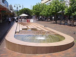
Epping is a suburb of Sydney, in the Australian state of New South Wales, 18 kilometres north-west of the Sydney central business district in the local government area of the City of Parramatta. Epping is located in the Northern Sydney region, which is sometimes simply referred to as the “North-West” or North Shore. The suburb is the most north-eastern area of the City of Parramatta. North Epping is a separate suburb to the north and under a different council, Hornsby Shire.

A3 (Sydney)

The A3 is a major metropolitan arterial route in Sydney. It was formerly designated as Metroad 3. The A3 runs from its intersection with the A8 at Mona Vale at the north end, to the southerly of its two intersections with A1, the Princes Highway, at Blakehurst the south end. The highest speed limit on the (A3) is 90 km/h (56 mph) on Mona Vale Road.

Hornsby Shire Local government area in New South Wales, Australia

Hornsby Shire is a local government area situated in Northern Sydney, as well as parts of the Hills District, in the state of New South Wales, Australia. The shire stretches from the M2 Hills Motorway in the south to the Hawkesbury River town of Wisemans Ferry, some 53 kilometres (33 mi) to the north, making it the largest local government council in the Greater Sydney Metropolitan region by total area. As of the 2016 census the shire had an estimated population of 142,667.

North Epping, New South Wales Suburb of Sydney, New South Wales, Australia

North Epping is a suburb of Sydney, in the state of New South Wales, Australia 19 kilometres north-west of the Sydney central business district in the local government area of Hornsby Shire. North Epping is in the Northern Sydney region, and is often referred to as part of the "North-West" or North Shore. Epping is a separate suburb to the south and under the Parramatta City Council, which shares the postcode of 2121.

Eastwood, New South Wales Suburb of Sydney, New South Wales, Australia

Eastwood is a suburb of Sydney, Australia. Eastwood is located 17 kilometres north-west of the Sydney central business district in the local government areas of the City of Ryde and the City of Parramatta. Eastwood is in the Northern Sydney region.

Thornleigh, New South Wales Suburb of Sydney, New South Wales, Australia

Thornleigh is a suburb on the Upper North Shore of Sydney in the state of New South Wales, Australia. Thornleigh is located 22 kilometres north-west of the Sydney central business district in the local government area of Hornsby Shire. The source of the Lane Cove River is located in Thornleigh.

Cherrybrook is a suburb of Sydney, in the state of New South Wales, Australia 27 kilometres north-west of the Sydney central business district in the local government area of Hornsby Shire. Cherrybrook is often referred to as being located in the Hills District of Sydney.

West Pennant Hills, New South Wales Suburb of Greater Western Sydney, New South Wales, Australia

West Pennant Hills is a suburb in the Hills District of Sydney, New South Wales, Australia. West Pennant Hills is located 20 km north-west of the Sydney central business district in the local government areas of The Hills Shire and Hornsby Shire. It is located halfway between Parramatta and Hornsby at the border of the North Shore and Greater Western Sydney. Pennant Hills is a separate suburb to the east with its own postcode.

Baulkham Hills, New South Wales Suburb of The Hills, New South Wales, Australia

Baulkham Hills is a suburb in the Hills District of Greater Western Sydney, in the state of New South Wales, Australia. It is 31 kilometres north-west of the Sydney central business district within the local government area of The Hills Shire, with a small portion south of the M2 Motorway in the City of Parramatta. Baulkham Hills is the administrative seat of The Hills Shire, an outer metropolitan shire within Greater Sydney. The suburb is also the most populous within the Hills Shire. It is known colloquially as "Baulko".

Mount Colah Suburb of Sydney, New South Wales, Australia

Mount Colah is an outer suburb of Northern Sydney, in the state of New South Wales, Australia 29 kilometres north of the Sydney central business district, in the local government area of Hornsby Shire.

Beecroft railway station Railway station in Sydney, New South Wales, Australia

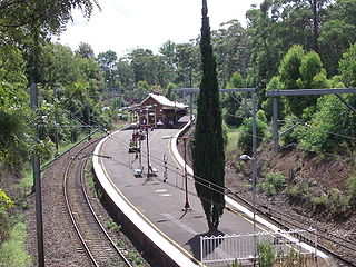
Beecroft railway station is located on the Main Northern line, serving the Sydney suburb of Beecroft. It is served by Sydney Trains T9 Northern Line services.

Arden Anglican School School in Australia

Arden Anglican School is an independent Anglican co-educational early learning, primary and secondary day school located in Beecroft and Epping, neighbouring suburbs on the North Shore of Sydney, New South Wales, Australia. Established in 1922 as a preparatory feeder school for the Presbyterian Ladies' College, Sydney, the school now caters for approximately 700 students from Pre-school to Year 12. Arden's first Year 12 class commenced in 2008. It used to be an only girls school in 1923 but 10 years later added the first ever boy and now it is a boys and girls school. Arden Anglican College is a member of the Association of Heads of Independent Schools of Australia (AHISA), the Independent Primary School Heads of Australia (IPSHAA) and Junior School Heads Association of Australia, the Association of Independent Co-Educational Schools, and the Association of Independent Schools of New South Wales.

Hornsby Heights, New South Wales Suburb of Sydney, New South Wales, Australia

Hornsby Heights is a suburb of Northern Sydney, in the state of New South Wales, Australia. Hornsby Heights is located 26 kilometres north-west of the Sydney central business district, in the local government area of Hornsby Shire. The suburb is often referred to as part of the Upper North Shore.

Pennant Hills Road Highway in Sydney, Australia

The Pennant Hills Road, a 15-kilometre (9.3 mi) section of the Cumberland Highway (A28), is a major urban highway located in Sydney, New South Wales, Australia. The road links the suburb of Wahroonga in the northeast, to the major central business district of Parramatta in the southwest.

Epping Road is a 10-kilometre-long (6.2 mi) arterial road located on the North Shore of Sydney, New South Wales, Australia. Epping Road is a major route linking the lower North Shore and Sydney central business district to the north western suburbs of the upper North Shore and Hills District of metropolitan Sydney, being a major access road to the commercial, industrial and university areas of North Ryde and Macquarie Park.

Northern Sydney Region of Sydney in New South Wales, Australia

Northern Sydney is a large metropolitan area in Sydney, New South Wales, Australia on the north shore of Sydney Harbour and Parramatta River. The region embraces suburbs in Sydney’s north-east, north and inner north west. Northern Sydney is divided into distinctive regions such as the North Shore, Northern Beaches and Forest District.

William Mark Nixon was an Australian architect active at the end of the 19th century and the first quarter of the 20th century. His work encompassed the styles of the Federation Bungalow in domestic design and Federation Free Classical in civic and commercial design. He was active in local government and was President of Hornsby Shire and an Alderman in the Municipality of Ashfield.

References

  1. 1 2 Australian Bureau of Statistics (27 June 2017). "Beecroft (State Suburb)". 2016 Census QuickStats. Retrieved 21 December 2017. OOjs UI icon edit-ltr-progressive.svg
  2. "Postcodes Australia - Qpzm". qpzm.com.au.
  3. "Info". www.belleproperty.com. Retrieved 18 January 2021.
  4. Phoenix Auctions History. "Post Office List" . Retrieved 18 January 2021.
  5. Beecroft and Cheltenham, The Shaping of a Sydney Community to 1914 (Beecroft Cheltenham History Group Inc, 1995). ISBN   0-646-24286-5
  6. "Hornsby Shire Council - History of Beecroft". Hornsby Shire Council. 2 May 2018.
  7. Beecroft-Cheltenham History Group Welcome. Retrieved 19 January 2020.
  8. Beecroft-Cheltenham History Group (1995), Beecroft and Cheltenham : the shaping of a Sydney community to 1914, The Group, ISBN   978-0-646-24286-6
  9. Barker, Helen; Goldberg, Lesley; Bartho, Catherine; Beecroft-Cheltenham History Group (2004), Beecroft and Cheltenham heritage walks, The Group, retrieved 19 January 2020
  10. Dortins, Emma; Beecroft Cheltenham Civic Trust; Beecroft-Cheltenham History Group. Library Sub-Group (2005), Beecroft Children's Library : giving the gift of reading, 1942-1998, Beecroft Cheltenham Civic Trust, ISBN   978-0-9758343-0-5
  11. "Bag Free Beecroft". Total Environment Centre.
  12. Beecroft Station Transport for NSW
  13. "Ozroads: NSW Metroad 2". www.ozroads.com.au.
  14. "St John's Beecroft - Home". www.beecroftanglicans.org.au.
  15. "Home". beecroftuniting.org.
  16. "Home | Beecroft Presbyterian Church". beecroftpresbyterian.org.au.
  17. "Contacts - Address". www.pennanthillsgolfclub.com.au. Pennant Hills Golf Club. Retrieved 29 October 2016.
  18. "The Beecroft Club". www.thebeecroftclub.com.au. Retrieved 29 October 2016.
  19. "Beecroft Lawn Tennis Club". www.beecrofttennis.com.au. Retrieved 29 October 2016.
  20. Beecroft Cheltenham Civic Trust – 109 Copeland Road. Retrieved 30 April 2014

Coordinates: 33°45′06″S151°03′48″E / 33.7518°S 151.0633°E / -33.7518; 151.0633