Provinces of Indonesia are the 37 administrative divisions of Indonesia and the highest tier of the local government. Provinces are further divided into regencies and cities, which are in turn subdivided into districts (kecamatan).

Nias is an island located off the western coast of Sumatra, Indonesia. Nias is also the name of the archipelago of which the island is the centre, but also includes the Batu Islands to the south-east and the small Hinako Islands to the west. Nias Island covers an area of 5,625.0 km2 (2,171.8 sq mi). It is mostly a lowland area rising to around 800 m (2,600 ft) above sea level. There were 756,338 inhabitants on the island at the 2010 Census; at the 2015 Census this had risen to 798,506 and the 2020 Census resulted in a total of 880,550.

Tangerang is a city in the province of Banten, Indonesia. Located on the western border of Jakarta, it is the third largest urban centre in the Greater Jakarta metropolitan area after Jakarta and Bekasi; the sixth largest city proper in the nation; and the largest city in Banten province. It has an area of 164.55 square kilometres and an official 2010 Census population of 1,798,601, which had risen to 1,895,486 at the 2020 Census. – making it the eighth most populated suburb in the world at the latter date; the official estimate as at mid 2021 was 1,911,914. It has not only functioned as a dormitory city, as there are many industrial areas such as Jatake, and several business districts, including CBD Alam Sutera in the area. Located just next to Jakarta on the west with many road access and improved infrastructure, such as new toll road, it is one of the favorite location for property seekers and investors in the Bodetabek area.

The Lingga Regency is a group of islands in Indonesia, located south of Singapore, along both sides of the equator, off the eastern coast of Riau Province on Sumatra island. They are south of the populated Riau Archipelago, known for the industrial island of Batam and the tourist-frequented island of Bintan, although the Lingga Islands themselves are rarely visited due to the infrequent local transportation. The equator goes through the northern tip of Lingga Island, the main island in the archipelago.
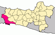
Cilacap Regency is a regency in the southwestern part of Central Java province in Indonesia. Its capital is the town of Cilacap.

Buleleng is a regency (kabupaten) of Bali, Indonesia. It has an area of 1,365.88 km2 and population of 624,125 at the 2010 census and 791,910 at the 2020 census. Its regency seat is at the town of Singaraja.

Kotabaru Regency is one of the eleven regencies in the Indonesian province of South Kalimantan. It consists of two parts; the smaller but more populated part comprises Laut Island, the largest island off the coast of Kalimantan, together with the smaller Sebuku Island off Laut Island's east coast and even smaller islands nearby; the larger but less populated part consists of districts on the mainland of Kalimantan. The regency has an area of 9,442.46 km2, and had a population of 290,142 at the 2010 Census and 325,622 at the 2020 Census. The official estimate as at mid 2021 was 329,483. The regency seat is located at the large town of Kotabaru at the northern tip of Laut Island.

Bintan Regency is an administrative area in the Riau Islands Province of Indonesia. Bintan Regency includes all of Bintan Island and also includes many outlying islands including the Tambelan Archipelago and Badas Islands situated between Bintan and West Kalimantan.

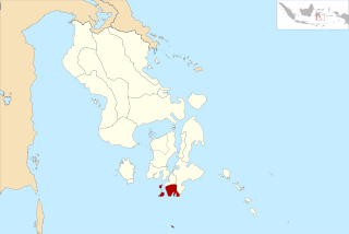
The Selayar Islands Regency is a regency of Indonesia in South Sulawesi province that covers the Selayar Islands, which lie to the south of Sulawesi. The regency covers an area of 1,357.03 km2, and had a population of 103,596 at the 2000 Census, 122,055 at the Census of 2010 and 137,071 at that of 2020. The official estimate for mid 2021 was 137,974. The Selayar Straits separate the regency from Sulawesi island.

The Taka Bonerate Islands in Indonesia consist of 28 atoll islands, together with the larger island of Kayuadi lying west of the atoll. They lie about 3 to 4 hours by boat from Benteng, the administrative capital of the Selayar Islands. Together they make up the Takabonerate District of Selayar Regency in South Sulawesi Province. It is part of a National Marine Park, with dive sites, pelagic fishes, dolphins, turtles, many soft corals, sea fans. Also it is the third largest atoll in the world.

East Lombok Regency is a regency of the Indonesian Province of West Nusa Tenggara. It is located on the island of Lombok, of which it comprises the eastern third ; the administrative capital is the town of Selong. The Regency covers an area of 1,605.55 km2 and had a population of 1,105,582 at the 2010 Census and 1,325,240 at the 2020 Census.
Taka Bonerate National Park is a marine park which includes the Takabonerate atoll islands, located in the Flores Sea, south of Sulawesi island of Indonesia.
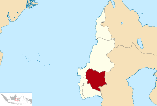
Mamasa Regency is one of the six regencies that make up the West Sulawesi Province, Indonesia, on the island of Sulawesi. It covers a land area of 3,005.88 km2. The population was 140,082 at the 2010 Census and 163,383 at the 2020 Census. Its capital is the town of Mamasa. The Mamasa people - which is a sub-group of the Toraja people - form the most common ethnic group.

Southeast Maluku Regency is a regency of Maluku, Indonesia. It is coincident with the Kei Islands, except that the city of Tual, although within the Kei Islands geographically and the seat of the Regency's administration, is technically independent of the Regency. The land area of the Regency is 1,031.81 km2, while the sea area administered by the regency was 3,181 km2; it had a population of 96,442 at the 2010 Census; this increased to 121,511 at the 2020 Census. The capital is located in Langgur.

Haji Aroeppala Airport, sometimes abbreviated H. Aroeppala Airport, is an airport in Selayar Regency, South Sulawesi, Sulawesi Island, Indonesia.
South Buton Regency is a regency located in Southeast Sulawesi. This regency was formed from the southern part of Buton Regency, from which it was separated by Act No.16 of 2014, dated 23 July 2014. It covers an area of 546.58 km2, and the population of the districts now comprising the new regency was 74,974 at the 2010 Census and 95,261 at the 2020 Census; the official estimate as at mid 2021 was 95,472. The regency capital is located in Batauga.
This is a list of emblems or coat of arms used in Indonesia. Indonesia is divided into 37 provinces, and each province is divided into regencies (kabupaten) and cities (kota). There are 416 regencies and 98 cities. Each province, regency, and city has its own emblem.
Persatuan Sepakbola Selayar Kepulauan is an Indonesian football club based in Selayar Islands Regency, South Sulawesi. They currently compete in the Liga 3.