Related Research Articles
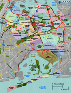
Queens is a borough of New York City, coextensive with Queens County, in the U.S. state of New York. Located on Long Island, it is the largest borough of New York City in area; it is bordered by the borough of Brooklyn at the western tip of Long Island to its west and Nassau County to the east. Queens also shares water borders with the boroughs of Manhattan, the Bronx, and Staten Island.

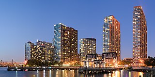
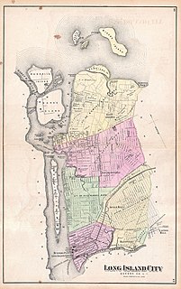
Long Island City (LIC) is a residential and commercial neighborhood on the extreme western tip of Queens, a borough in New York City. It is bordered by Astoria to the north; the East River to the west; Hazen Street, 49th Street, and New Calvary Cemetery in Sunnyside to the east; and Newtown Creek—which separates Queens from Greenpoint, Brooklyn—to the south.

Astoria is a neighborhood in the western portion of the New York City borough of Queens. Astoria is bounded by the East River and is adjacent to three other Queens neighborhoods: Long Island City to the southwest, Sunnyside to the southeast, and Woodside to the east. As of 2019, Astoria has an estimated population of 95,446.

The government of New York City, headquartered at New York City Hall in Lower Manhattan, is organized under the New York City Charter and provides for a mayor-council system. The mayor is elected to a four-year term and is responsible for the administration of city government. The New York City Council is a unicameral body consisting of 51 members, each elected from a geographic district, normally for four-year terms. All elected officials—other than those elected before 2010, who are limited to three consecutive terms—are subject to a two consecutive-term limit. The court system consists of two citywide courts and three statewide courts.

Cypress Hills Cemetery was the first non-sectarian/non-denominational cemetery corporation organized in the boroughs of Brooklyn and Queens in New York City. The cemetery is run as a non-profit organization and is located at 833 Jamaica Avenue in Brooklyn in the Cemetery Belt on the border of both boroughs, and its 225 acres are divided by the Jackie Robinson Parkway. Cypress Hills Cemetery retains its two primary entrances at Jamaica Avenue and Cooper Avenue. Cemetery of the Evergreens lies directly to the southwest.

Woodside is a residential and commercial neighborhood in the western portion of the borough of Queens in New York City. It is bordered on the south by Maspeth, on the north by Astoria, on the west by Sunnyside, and on the east by Elmhurst, Jackson Heights, and East Elmhurst. Some areas are widely residential and very quiet, while other parts, especially the ones around Roosevelt Avenue, are busier.
The Borough president is an elective office in each of the five Boroughs of New York City. For most of the city's history, the office exercised significant executive powers within each borough, and the five borough presidents also sat on the New York City Board of Estimate. Since 1990, the borough presidents have been stripped of a majority of their powers in the government of New York City.

New York City is composed of five boroughs: The Bronx, Brooklyn, Manhattan, Queens, and Staten Island. Each borough is coextensive with a respective county of New York State, making New York City one of the U.S. municipalities in multiple counties. The boroughs of Queens and the Bronx are also Queens County and Bronx County. The other three counties are named differently from their boroughs: Manhattan is New York County, Brooklyn is Kings County, and Staten Island is Richmond County.
Board of Estimate of City of New York v. Morris, 489 U.S. 688 (1989), was a case argued before the United States Supreme Court regarding the structure of the New York City Board of Estimate.
Joseph Bradley Varnum Jr. was an American lawyer and politician.
Frederick Bowley (1851–1916) was an American politician, who served as the first executive of the Borough of Queens in New York City.
The La Guardia and Wagner Archives was established in 1982 at LaGuardia Community College in Long Island City, Queens, New York, to collect, preserve, and make available primary materials documenting the social and political history of New York City, with an emphasis on the mayoralty and the borough of Queens. The purpose of its founding went beyond serving as a repository, but to establish the college as a location for scholarly research. The archives serves a broad array of researchers, journalists, students, scholars, exhibit planners, and policy makers. Its web site provides guidelines to the collections, as well as over 55,000 digitized photographs and close to 2,000,000 digitized documents.
Udalls Cove is a marshland and wetland area located in Queens, New York City, off Little Neck Bay between Douglaston and Little Neck Bay. It is one of the few remaining salt marshes on the North Shore in the Metropolitan area; another being the salt marsh southwest of the cove, at Alley Pond Park. For many years, activists and locals have struggled to ensure that these marshlands and wetlands were properly preserved in their natural state by preventing development in the region. These marshlands/wetlands are home to bird and animal life such as muskrats, egrets, and herons, as well as marine life and plants. One of the key agitators to preserve Udall's Cove and its plant and animal Life was Aurora Gareiss, founder of the Udalls Cove Preservation Committee.
G. H. Nichols and Company was an American industrial company founded by William Henry Nichols and his partner, Charles W. Walter.

First Reformed Church of Astoria was organized and established in 1839 and continues to operate, both as a church and as a center for family and holiday-oriented events.
The following is a timeline of the history of the borough of Queens in New York City, New York, USA.
Sunswick Creek is a buried stream located in Astoria and Long Island City, in the northwestern portion of Queens in New York City. It originated to the north of Queensboro Bridge and Queens Plaza in Long Island City, flowing north to the present-day site of the Socrates Sculpture Park in Astoria, and emptying into the East River. The creek was named for a term in the Algonquin language that likely means "Woman Chief" or "Sachem’s Wife."
James T. Hallinan was an American lawyer and judge from New York.
Queens Directories – of New York City – were, before 1898, an assortment of village directories, Queens County directories, Long Island Directories, and add-ins or partial inclusions to New York City directories. In 1898, 30% of the western part of the old Queens County was absorbed into New York City. Before 1898, Nassau County covered the eastern 70% of the old Queens County. The older, larger Queens County was mostly agricultural, and within it were several towns, villages, and hamlets. In the mid- to late-19th century, cemeteries constituted one of the larger industries in Queens, Kings (Brooklyn), and Westchester Counties. As of 1898, Queens County, New York, and the Borough of Queens, New York City, geographically, have been the same. Both Queens and Brooklyn are on Long Island.
References
- 1 2 3 4 5 6 7 8 Website. Anonymous. Guide to the Berrien's Island Supreme Court Case Records 1849-1851 Control # B-19, Long Island Division, Queens Borough Public Library: http://www.queenslibrary.org/research/archives/manuscripts/b-19.xml Archived 2015-09-24 at the Wayback Machine .
- ↑ Basket Ball Flyer: College Point A. C. vs. Tremont B. B. team, Anonymous, December 23, 1914, Document Case Box 489h, Folder 11, Coll. B-19, Berrien's Island Supreme Court Case Records, 1849-1851, Long Island Division, Queens Borough Public Library.
- 1 2 3 4 5 6 7 8 9 Letter, Edwin Smith to George F. Clarke, November 1849, Folder 15, Coll. B-19, Berrien's Island Supreme Court Case Records, 1849-1851, Long Island Division, Queens Borough Public Library.
- 1 2 3 4 5 6 7 8 9 10 Letter of Complaint, Anonymous (Griffin, Edmund and Charles Crane), September 24th, 1849, Box 489h, Folder 20, Coll. B-19, Berrien's Island Supreme Court Case Records, 1849-1851, Long Island Division, Queens Borough Public Library.
- 1 2 3 4 Court Case: (Edwards, Charles, Plaintiffs Attorney, New York). “Document No. 6: Board of Assistant Aldermen, September 24th, 1849”, Anonymous (Edwards, Charles, Plaintiffs Attorney, New York), Box 489h, Folder 22, Coll. B-19, Berrien's Island Supreme Court Case Records, 1849-1851, Long Island Division, Queens Borough Public Library.
