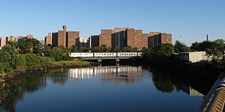
Coney Island Creek is a 1.8-mile-long (2.9 km) tidal inlet in Brooklyn, New York City. It was created from a series of streams and inlets by land filling and digging activities starting in the mid-18th century which, by the 19th century, became a 3-mile-long (4.8 km) continual strait and a partial mudflat connecting Gravesend Bay and Sheepshead Bay, separating Coney Island from the mainland. The strait was closed off in the early 20th century due to further land development and later construction projects. Today only the western half of Coney Island Creek exists.

Gravesend is a neighborhood in the south-central section of the New York City borough of Brooklyn, on the southwestern edge of Long Island in the U.S. state of New York. It is bounded by the Belt Parkway to the south, Bay Parkway to the west, Avenue P to the north, and Ocean Parkway to the east.

The Marine Parkway–Gil Hodges Memorial Bridge is a vertical-lift bridge in New York City, New York, that crosses Rockaway Inlet. The bridge, which opened on July 3, 1937, connects the Rockaway Peninsula in Queens, with Flatbush Avenue to Floyd Bennett Field, Belt Parkway, and the Marine Park neighborhood in Brooklyn. The bridge is designated as New York State Route 901B, an unsigned reference route.
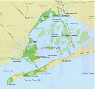
Rockaway Inlet is a strait connecting Jamaica Bay, wholly within New York City, with the Atlantic Ocean. It separates the Rockaway Peninsula in Queens from the Floyd Bennett Field in Brooklyn.
Barren Island is a peninsula and former island on the southeast shore of Brooklyn in New York City. Located on Jamaica Bay, it was geographically part of the Outer Barrier island group on the South Shore of Long Island. The island was occupied by the Lenape Native Americans prior to the arrival of Dutch settlers in the 17th century. Its name is a corruption of Beeren Eylandt, the Dutch-language term for "Bears' Island".

The Rockaway Peninsula, commonly referred to as The Rockaways or Rockaway, is a peninsula at the southern edge of the New York City borough of Queens on Long Island, New York. Relatively isolated from Manhattan and other more urban parts of the city, Rockaway became a popular summer retreat in the 1830s. It has since become a mixture of lower, middle, and upper-class neighborhoods. In the 2010s, it became one of the city's most quickly gentrifying areas.

Gerritsen Beach is a neighborhood in the New York City borough of Brooklyn, located between Sheepshead Bay to the west and Marine Park to the east. The area is served by Brooklyn Community Board 15. The population of the neighborhood is 4,797 as of the 2020 U.S. census.

Sheepshead Bay is a neighborhood in southern Brooklyn, New York City. It is bounded by Ocean Parkway to the west; Avenue T and Kings Highway to the north; Nostrand Avenue and Gerritsen Avenue to the east; and the Atlantic Ocean to the south. Sheepshead Bay is abutted by the neighborhoods of Brighton Beach and Homecrest to the west; Midwood to the north; and Gerritsen Beach to the east.

Broad Channel is a neighborhood in the southern portion of the New York City borough of Queens. It occupies the southern portion of Rulers Bar Hassock, the only inhabited island in Jamaica Bay.
Belle Harbor is a small residential neighborhood in the New York City borough of Queens, located on the western half of the Rockaway Peninsula, the southernmost area of the borough. Belle Harbor commonly refers to the area from Beach 126th to Beach 141st Streets.
Brooklyn Community Board 15 is a New York City community board that encompasses the Brooklyn neighborhoods of Gravesend, Sheepshead Bay, Manhattan Beach, Gerritsen Beach, Madison, Homecrest, and Plum Beach. It is delimited by Corbin Place, Coney Island Avenue, Avenue Y, 86th street, Avenue U and McDonald Avenue, Avenue P and Kings Highway on the north, Nostrand avenue and Marine Park on the east, as well as by the Atlantic Ocean on the south.

Community boards of Brooklyn are New York City community boards in the borough of Brooklyn, which are the appointed advisory groups of the community districts that advise on land use and zoning, participate in the city budget process, and address service delivery in their district.

Hog Island was the name of two islands near Long Island, New York until the 1890s. One is the present day Barnum Island, which includes the villages of Island Park and Harbor Isle in Nassau County. The other was a mile-long (1600 m) barrier island that existed to the south of Rockaway Beach in Queens before being mostly destroyed by the 1893 New York hurricane and completely lost to erosion and storm damage by 1902.
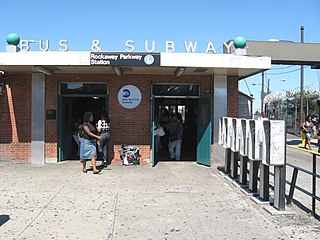
The Canarsie–Rockaway Parkway station is the southern terminal station of the BMT Canarsie Line of the New York City Subway, and is one of the few grade-level stations in the system. Located at the intersection of Rockaway Parkway and Glenwood Road in the Canarsie neighborhood of Brooklyn, it is served by the L train at all times.

Rockaway Park is a neighborhood in the New York City borough of Queens. The area is on the Rockaway Peninsula, nestled between Jamaica Bay to the north and the Atlantic Ocean to the south. The neighborhood of Rockaway Beach lies on its eastern border while the community of Belle Harbor is situated on its western side. The neighborhood is part of Queens Community Board 14.

Jacob Riis Park, also called Jacob A. Riis Park and Riis Park, is a seaside park on the southwestern portion of the Rockaway Peninsula in the New York City borough of Queens. It lies at the foot of the Marine Parkway–Gil Hodges Memorial Bridge, east of Fort Tilden, and west of Neponsit and Rockaway Beach. Originally run by the New York City Department of Parks and Recreation, it later became part of the Jamaica Bay Unit of the Gateway National Recreation Area, and is managed by the National Park Service (NPS). It features an extensive sand beach along the Atlantic Ocean coastline and several historic Art Deco structures.

The Q35 bus route constitutes a public transit line in southeast Brooklyn as well as the Rockaway Peninsula of southern Queens in New York City. The Q35 is operated by MTA Regional Bus Operations under the MTA Bus Company brand, but was formerly privately operated by Green Bus Lines. The bus provides service between Midwood in central Brooklyn to Rockaway Park on the Rockaway Peninsula, running mainly along Flatbush Avenue in Brooklyn and Newport Avenue on the Rockaway Peninsula. The route utilizes the Marine Parkway–Gil Hodges Memorial Bridge to cross between Brooklyn and Queens.
The Manhattan Beach Branch, Manhattan Beach Line, or Manhattan Beach Division was a line of the Long Island Rail Road, running from Fresh Pond, Queens, south to Manhattan Beach, Brooklyn, New York City, United States. It opened in 1877 and 1878 as the main line of the New York and Manhattan Beach Railway. The tracks from Flatbush south to Manhattan Beach were removed from 1938 to 1941, while most of the rest is now the freight-only Bay Ridge Branch.
Bergen Beach is a residential neighborhood in the borough of Brooklyn, New York City. It is located on a peninsula abutting Jamaica Bay in the southeastern portion of the borough, and is bordered by Mill Basin and the neighborhood of the same name to the south and west; the neighborhood of Flatlands to the northwest; Paerdegat Basin and the neighborhood of Canarsie to the northeast; and Jamaica Bay and the Belt Parkway to the east. Bergen Beach contains a sub-neighborhood named Georgetown. The vast majority of residents are white, and the neighborhood generally has a suburban quality.


