Clinton Hill is a neighborhood in north-central Brooklyn, a borough of New York City. It is bordered by the Brooklyn Navy Yard and Flushing Avenue to the north, Williamsburg to the northeast, Nostrand Avenue and Bedford–Stuyvesant to the east, St Marks Avenue and Prospect Heights to the south and southwest and Carlton Avenue and Fort Greene to the west.

Fort Greene is a neighborhood in the northwestern part of the New York City borough of Brooklyn. The neighborhood is bounded by Flushing Avenue and the Brooklyn Navy Yard to the north, Flatbush Avenue Extension and Downtown Brooklyn to the west, Atlantic Avenue and Prospect Heights to the south, and Vanderbilt Avenue and Clinton Hill to the east. The Fort Greene Historic District is listed on the New York State Registry and on the National Register of Historic Places, and is a New York City designated historic district.

Williamsburg is a neighborhood in the New York City borough of Brooklyn, bordered by Greenpoint to the north; Bedford–Stuyvesant to the south; Bushwick and East Williamsburg to the east; and the East River to the west. It was an independent city until 1855, when it was annexed by Brooklyn; around that time, the spelling was changed from Williamsburgh to Williamsburg.
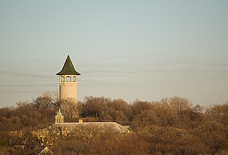
Prospect Park is a historic neighborhood within the University community of the U.S. city of Minneapolis, Minnesota. The area is bounded by the Mississippi River to the south, the City of Saint Paul, Minnesota to the east, the Burlington Northern railroad yard to the north, and the Stadium Village commercial district of the University of Minnesota to the west. The neighborhood is composed of several districts which include the East River Road area. The 1913 Prospect Park Water Tower is a landmark and neighborhood icon.

Boerum Hill is a small neighborhood in the northwestern portion of the New York City borough of Brooklyn, bounded by Schermerhorn Street to the north and Fourth Avenue to the east. The western border is variously given as either Smith or Court Streets, and Warren or Wyckoff Streets as the southern edge.

Bedford–Stuyvesant, colloquially known as Bed–Stuy, is a neighborhood in the northern section of the New York City borough of Brooklyn. Bedford–Stuyvesant is bordered by Flushing Avenue to the north, Classon Avenue to the west, Broadway to the east, and Atlantic Avenue to the south. The main shopping street, Fulton Street, runs east–west the length of the neighborhood and intersects high-traffic north–south streets including Bedford Avenue, Nostrand Avenue, and Stuyvesant Avenue. Bedford–Stuyvesant contains four smaller neighborhoods: Bedford, Stuyvesant Heights, Ocean Hill, and Weeksville. Part of Clinton Hill was once considered part of Bedford–Stuyvesant.
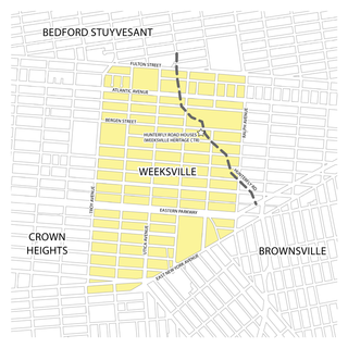
Weeksville is a historic neighborhood founded by free African Americans in what is now Brooklyn, New York, United States. Today it is part of the present-day neighborhood of Crown Heights.

Vinegar Hill is a neighborhood in the borough of Brooklyn in New York City on the East River Waterfront between Dumbo and the Brooklyn Navy Yard. The neighborhood is locally governed by Brooklyn Community Board 2 and is policed by the New York City Police Department's 84th Precinct. The large Irish-American population in Vinegar Hill made it one of several New York City neighborhoods once known colloquially as Irishtown.
The Weeksville Heritage Center is a historic site on Buffalo Avenue between St. Marks Avenue and Bergen Street in Crown Heights, Brooklyn, New York City. It is dedicated to the preservation of Weeksville, one of America's first free black communities during the 19th century. Within this community, the residents established schools, churches and benevolent associations and were active in the abolitionist movement. Weeksville is a historic settlement of national significance and one of the few remaining historical sites of pre-Civil War African-American communities.

Good Hope is a residential neighborhood in southeast Washington, D.C., near Anacostia. The neighborhood is generally middle class and is dominated by single-family detached and semi-detached homes. The year-round Fort Dupont Ice Arena skating rink and the Smithsonian Institution's Anacostia Museum are nearby. Good Hope is bounded by Fort Stanton Park to the north, Alabama Avenue SE to the south, Naylor Road SE to the west, and Branch Avenue SE to the east. The proposed Skyland Shopping Center redevelopment project is within the boundaries of the neighborhood.

Flushing Avenue is a street running through northern Brooklyn and western Queens, beginning at Nassau Street in Fort Greene, Brooklyn, and ending at Grand Avenue in Maspeth. It divides the neighborhood of Williamsburg from Clinton Hill and East Williamsburg from Bushwick. After crossing the Queens border, the avenue serves as the dividing line between Ridgewood, Queens and West Maspeth. Flushing Avenue then terminates in Maspeth. Despite its name, however, the avenue does not extend to Flushing.
The West Bronx is a region in the New York City borough of the Bronx. The region lies west of the Bronx River and roughly corresponds to the western half of the borough.

The Jackie Robinson House is a historic house at 5224 Tilden Avenue in the Brooklyn borough of New York City. Built c. 1912-1916, it is prominent as the home of baseball great Jackie Robinson from 1947, when he was awarded Rookie of the Year, through 1949, when he was voted Most Valuable Player. It was declared a National Historic Landmark in 1976.

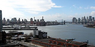
The Brooklyn Navy Yard is a shipyard and industrial complex located in northwest Brooklyn in New York City, New York. The Navy Yard is located on the East River in Wallabout Bay, a semicircular bend of the river across from Corlears Hook in Manhattan. It is bounded by Navy Street to the west, Flushing Avenue to the south, Kent Avenue to the east, and the East River on the north. The site, which covers 225.15 acres (91.11 ha), is listed on the National Register of Historic Places.
This is a timeline and chronology of the history of Brooklyn, New York. Brooklyn is the most populous of New York City's boroughs, and was settled in 1646.
The following is an alphabetical list of articles related to New York City. New York City is a city in the U.S. state of New York.