West Midwood, Brooklyn

Last updated

West Midwood
West Midwood at the Corner of Rugby Road and Foster Road.jpg
West Midwood at the corner of Rugby Road and Foster Road
West Midwood, Brooklyn
Location in New York City
Coordinates: 40°37′52″N73°57′50″W / 40.631°N 73.964°W / 40.631; -73.964
Country Flag of the United States.svg  United States
State Flag of New York.svg  New York
City Flag of New York City.svg New York City
Borough Flag of Brooklyn, New York.svg Brooklyn
Community District Brooklyn 14 [1]
ZIP Code
11230
Area code(s) 718, 347, 929, and 917

West Midwood is a planned community and historic enclave in the New York City borough of Brooklyn. West Midwood is located in central Brooklyn in the southern edge of the community of Victorian Flatbush, abutting the northern boundary of the community of Midwood. [2] [3] It is bordered by Foster Avenue to the north, the BMT Brighton subway line ( B and Q trains) to the east, Avenue H to the south, and Coney Island Avenue to the west. [4] West Midwood is located south of Prospect Park within what is sometimes referred to as Ditmas Park. [5]

Contents

West Midwood, along with other neighborhoods within Ditmas Park, is policed by the 70th Precinct of the New York City Police Department. [6] West Midwood is part of Brooklyn Community District 14. [1]

History

Spurred by its success developing Vanderveer Park, the first Victorian Flatbush neighborhood, in 1899, the Germania Real Estate and Improvement Company (Germania) purchased the land on which West Midwood and neighboring communities Midwood Park and Fiske Terrace were to be built. [7] The land was purchased from the Lott family’s extensive farmland holdings, which dated back over 200 years to Peter Lott, who migrated to Flatbush, from Holland in 1652. [8] V’lacks Bos (Anglicized Flatbush), meaning “wooded plain” in Dutch, also carried the name Midwout (Anglicized Midwood), meaning “middle-woods” in Dutch, and the names both reflected the wooded nature of the area and contrasted against Flatlands, an area to the south that was devoid of woods. [9]

In addition to development by Germania, between 1905 and 1908, architect and builder Thomas Benton Ackerson’s eponymous T.B. Ackerson Company, simultaneously built and sold forty-two detached homes along Westminster Road in West Midwood for $10,000 each. [7] Design and construction of these houses conformed to Ackerson’s “village in the city” vision and houses were graced with columns and fine details. [10] [11] Similarly, Germania advertised the neighborhood as “country living in the city.” To maintain its suburban aesthetic, utilities and train tracks were kept underground and streets were lined with trees, mainly London Planes and maples. Further keeping with the park-like ambiance, the original property deeds forbade construction of front yard fences. [11]

In keeping with West Midwood’s small-town character, residents host annual community-building events such as a Progressive Dinner, a Halloween Parade for the children of Flatbush, [12] and a summer block party, in addition to publishing a seasonal newsletter, among other activities. New residents are invited to join the West Midwood Community Association, which dates back to the neighborhood’s early years.

Transportation

New York City Subway stations serving West Midwood are Newkirk Plaza ( B and Q trains) and Avenue H ( Q train). MTA buses traveling through the area include the B8 and B68. [13] Bike lanes connect West Midwood to greater Victorian Flatbush, Cortelyou Road, Prospect Park and its Parade Ground, Brooklyn College, and Ocean Parkway. [14]

Related Research Articles

<span class="mw-page-title-main">Midwood, Brooklyn</span> Neighborhood of Brooklyn in New York City

Midwood is a neighborhood in the south-central part of the New York City borough of Brooklyn. It is bounded on the north by the Bay Ridge Branch tracks just above Avenue I and by the Brooklyn College campus of the City University of New York, and on the south by Avenue P and Kings Highway. The eastern border consists of parts of Nostrand Avenue, Flatbush Avenue, and Coney Island Avenue; parts of McDonald Avenue and Ocean Parkway mark the western boundary.

<span class="mw-page-title-main">Flatbush, Brooklyn</span> Neighborhood of Brooklyn in New York City

Flatbush is a neighborhood in the New York City borough of Brooklyn. The neighborhood consists of several subsections in central Brooklyn and is generally bounded by Prospect Park to the north, East Flatbush to the east, Midwood to the south, and Kensington and Parkville to the west. The neighborhood had a population of 105,804 as of the 2010 United States Census. The modern neighborhood includes or borders several institutions of note, including Brooklyn College.

<span class="mw-page-title-main">Kensington, Brooklyn</span> Neighborhood of Brooklyn in New York City

<span class="mw-page-title-main">East Flatbush, Brooklyn</span> Neighborhood of Brooklyn in New York City

East Flatbush is a residential neighborhood in the New York City borough of Brooklyn. East Flatbush is bounded by Crown Heights and Empire Boulevard to the north; Brownsville and East 98th Street to the east; Flatlands, Canarsie and the Long Island Rail Road's Bay Ridge Branch to the south; and the neighborhood of Flatbush and New York Avenue to the west. East Flatbush is a predominantly African American neighborhood and has a population of 135,619 as of the 2010 United States census.

Fiske Terrace is a planned community and neighborhood in the New York City borough of Brooklyn. Fiske Terrace is located in south central Brooklyn in the southern edge of the community of Flatbush and north of the community of Midwood. It is bounded by Glenwood Road on the north, Ocean Avenue on the east, the Bay Ridge Branch of the Long Island Rail Road/New York and Atlantic Railway right-of-way on the south, and the New York City Subway BMT Brighton Line subway line on the west.

<span class="mw-page-title-main">Prospect Park South</span> United States historic place

Prospect Park South is a small neighborhood in Flatbush, Brooklyn, New York City, located south of Prospect Park. It is included within the Prospect Park South Historic District, which was designated by the New York City Landmarks Preservation Commission in 1979 and listed on the National Register of Historic Places in 1983. The historic district is bounded by Church Avenue to the north, the BMT Brighton Line of the New York City Subway to the east, Beverley Road to the south, and between Stratford Road and Coney Island Avenue to the west.

<span class="mw-page-title-main">T. B. Ackerson Company</span>

T.B. Ackerson Company was a real estate development company that built several planned communities in the New York metropolitan area during the late 19th and early 20th centuries.

Brooklyn Community Board 17 is a New York City community board that encompasses the Brooklyn neighborhoods of East Flatbush, Remsen Village, Farragut, Rugby, Erasmus and Ditmas Village. The District is delimited by East 32nd Street, Glenwood Road, Nostrand Avenue, Foster Avenue, and Bedford Avenue on the west, Clarkson Avenue, Utica Avenue, and East New York Avenue on the north, East 98th Street on the east, as well as by the Long Island Rail Road on the south.

<span class="mw-page-title-main">Community boards of Brooklyn</span>

Community boards of Brooklyn are New York City community boards in the borough of Brooklyn, which are the appointed advisory groups of the community districts that advise on land use and zoning, participate in the city budget process, and address service delivery in their district.

<span class="mw-page-title-main">Ditmas Park, Brooklyn</span> United States historic place

Ditmas Park is a historic district in the neighborhood of Flatbush in Brooklyn, New York City. The traditional boundaries of Ditmas Park, including Ditmas Park West, are Ocean Avenue and greater Flatbush to the east, Dorchester Road and the Prospect Park South neighborhood to the north, Coney Island Avenue and the Kensington neighborhood to the west, and Newkirk Avenue to the south. The name Ditmas Park is often used as a shorthand for the several neighborhoods that comprise the larger area of Victorian Flatbush.

<span class="mw-page-title-main">Marine Park (neighborhood), Brooklyn</span> Neighborhood in Brooklyn, New York City

Marine Park is a neighborhood in the New York City borough of Brooklyn. The neighborhood lies between Flatlands and Mill Basin to the east, and Gerritsen Beach, Midwood, and Sheepshead Bay to the south and west. It is mostly squared off in area by Gerritsen Avenue, Flatbush Avenue, Avenue U and Kings Highway. The neighborhood's eponymous park is the largest public park in Brooklyn. Charles Downing Lay won a silver medal in town planning at the 1936 Olympics for the planning of Marine Park.

<span class="mw-page-title-main">Avenue H station</span> New York City Subway station in Brooklyn

The Avenue H station is a local station on the BMT Brighton Line of the New York City Subway. It is located at Avenue H between East 15th and East 16th Streets near the border of Midwood and Flatbush, Brooklyn. The station is served by the Q train at all times.

<span class="mw-page-title-main">Newkirk Plaza station</span> New York City Subway station in Brooklyn

The Newkirk Plaza station is an express station on the BMT Brighton Line of the New York City Subway in Flatbush, Brooklyn. It is located on an open-cut at the center of the pedestrian-only Newkirk Plaza shopping mall, which is bounded by Newkirk Avenue on the north, Foster Avenue on the south, Marlborough Road to the west, and East 16th Street to the east. The station is served by the Q train at all times and by the B train on weekdays only.

<span class="mw-page-title-main">Prospect Lefferts Gardens</span> Neighborhood of Brooklyn in New York City

Prospect Lefferts Gardens is a residential neighborhood in the Flatbush area of the New York City borough of Brooklyn. The community is bounded by Empire Boulevard to the north, Clarkson Avenue to the south, New York Avenue to the east, and Ocean Avenue/Prospect Park to the west. Prospect Lefferts Gardens was designated a New York City Landmark area in 1979 and called the Prospect Lefferts Gardens Historic District.

<span class="mw-page-title-main">Bedford Avenue</span> Avenue in Brooklyn, New York

Bedford Avenue is the longest street in Brooklyn, New York City, stretching 10.2 miles (16.4 km) and 132 blocks, from Manhattan Avenue in Greenpoint south to Emmons Avenue in Sheepshead Bay, and passing through the neighborhoods of Williamsburg, Bedford-Stuyvesant, Crown Heights, Flatbush, Midwood, Marine Park, and Sheepshead Bay.

<span class="mw-page-title-main">Beverley Squares</span> Neighborhoods of Brooklyn in New York City

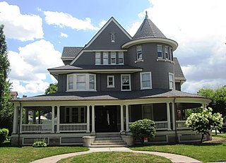
Beverley Square East and Beverley Square West, also spelled Beverly Square, are a pair of neighborhoods in the Flatbush section of the New York City borough of Brooklyn. Located southwest of Prospect Park within what is now called Victorian Flatbush, one of the largest concentrations of Victorian houses in the United States, they were developed in the 1900s primarily by Thomas Benton Ackerson, whose former home is in Beverley Square West.

<span class="mw-page-title-main">Victorian Flatbush</span> Neighborhood of Brooklyn in New York City

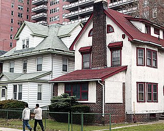
Victorian Flatbush is the western section of the Flatbush section of Brooklyn, New York, bordering Midwood, that is characterized by Victorian houses.

<span class="mw-page-title-main">Flatbush Malls</span> Traffic medians in Brooklyn, New York

The Flatbush Malls are a pair of tree-lined landscaped medians series along several roads in the Victorian Flatbush neighborhood of Brooklyn, New York City. An architecture critic has written that the malls "give the streets an uncommon spaciousness, if not grandeur". The first series was built in the northern part of the neighborhood along Albemarle Road, and extending one block north on Buckingham Road, in the Prospect Park South development of 1899, east of Coney Island Avenue and west of the BMT Brighton Line. This was modeled by the Scottish landscape architect John Aiken on Commonwealth Avenue Mall in Boston, with a design that originally included shrubbery but not trees, and in turn likely inspired the other neighborhood series.

References

  1. 1 2 "NYC Planning | Community Profiles". communityprofiles.planning.nyc.gov. New York City Department of City Planning. Retrieved April 7, 2018.
  2. Toy, Vivian S. (December 4, 2009). "Living in: Midwood, Brooklyn". The New York Times. ISSN   0362-4331 . Retrieved February 5, 2016.
  3. "Greater Ditmas Park Or West Midwood?". The New York Times. August 2, 1998. ISSN   0362-4331 . Retrieved February 5, 2016.
  4. "Map of Victorian Flatbush". The Ditmas Park Association. Archived from the original on February 6, 2016. Retrieved February 6, 2016.
  5. Crean, Sarah (February 29, 2016). "Ditmas Park Is Not Part Of Flatbush, Says New York Times". Ditmas Park Corner. Archived from the original on March 15, 2016. Retrieved March 2, 2016.
  6. "NYPD - Precincts". www.nyc.gov. Retrieved February 6, 2016.
  7. 1 2 Allbray, Neda C. (November 11, 2004). Flatbush: The Heart Of Brooklyn (NY) (The Making of America). Arcadia Publishing. p. 148. ISBN   978-0738524535.
  8. Linder, Marc; Zacharias, Lawrence S. (December 1, 1999). Of Cabbages and Kings County: Agriculture and the Formation of Modern Brooklyn . University Of Iowa Press. pp.  163-164. ISBN   978-0877457145.
  9. Benardo, Leonard; Weiss, Jennifer (July 1, 2006). Brooklyn by Name: How the Neighborhoods, Streets, Parks, Bridges and More Got Their Names . NYU Press. pp.  103. ISBN   978-0814799468.
  10. "Cortelyou" (PDF). Flatbush Development Corporation. September 2013. Archived from the original (PDF) on February 6, 2016.
  11. 1 2 Redmond, Robin (December 28, 2012). "Victorian Flatbush's Request for Evaluation" (PDF). Historic Districts Council. pp. 351–352.
  12. Enright, Joe (June 2007). "The View from Argyle Heights". The View from Argyle Heights. Joe Enright. Retrieved September 9, 2016.
  13. "Brooklyn Bus Map" (PDF). Metropolitan Transportation Authority. October 2020. Retrieved December 1, 2020.
  14. "Argyle, Rugby, Westminster, Stratford & Beverley Roads" (PDF). New York City Department of Transportation. April 21, 2015.