Prospect Park South

Last updated

Prospect Park South Historic District
1306 Albemarle Road Prospect Park South from front.jpg
John S. Eakins House (1905) at 1306 Albemarle Road
Prospect Park South
LocationRoughly bounded by BMT Brighton Line, Beverley Rd., and Coney Island and Church Aves.
Brooklyn, New York City
Coordinates 40°38′46″N73°58′02″W / 40.646111°N 73.967222°W / 40.646111; -73.967222 Coordinates: 40°38′46″N73°58′02″W / 40.646111°N 73.967222°W / 40.646111; -73.967222
Area47 acres (19 ha)
Built1899 (1899)
Architectmultiple
Architectural stylemultiple
NRHP reference No. 83001699 [1]
NYCL No.0979
Significant dates
Added to NRHPJuly 21, 1983
Designated NYCLFebruary 8, 1979

Prospect Park South is a small neighborhood in Flatbush, Brooklyn, New York City, located south of Prospect Park. It is included within the Prospect Park South Historic District, which was designated by the New York City Landmarks Preservation Commission in 1979 [2] and listed on the National Register of Historic Places in 1983. [1] The historic district is bounded by Church Avenue to the north, the BMT Brighton Line ( B and Q trains) of the New York City Subway to the east, Beverley Road to the south, and between Stratford Road and Coney Island Avenue to the west. [3]

Contents

Prospect Park South, along with other neighborhoods within Flatbush, is policed by the 70th Precinct of the New York City Police Department. [4]

History

In 1899, developer Dean Alvord purchased about 60 acres (24 ha) of farmland in order to create Prospect Park South, a community of substantial homes, a "rural park within the limitations of the conventional city block and city street." [2] Alvord characterized the development as rus in urbe, the country in the city. [5] [6] The location was selected to take advantage of the train service on the Brooklyn and Brighton Beach Railroad of the Brooklyn Rapid Transit Company (BRT). The line, now known as the BMT Brighton Line, offered express and local train service that remains to this day. The trains emerged at Fulton Street as an elevated line and continued across the Brooklyn Bridge to Manhattan. [7]

Gatepost at Church Avenue & Buckingham Road. Gateposts such as this mark many of the entrances to streets in the historic district. Prospect Park South gatepost jeh.JPG
Gatepost at Church Avenue & Buckingham Road. Gateposts such as this mark many of the entrances to streets in the historic district.

Once he had purchased the land, Alvord laid out all the necessary utilities and marked the entrance of most streets with brick piers with cast concrete plaques bearing the bas-relief inscription "PPS". He also hired John Aitkin, a Scottish landscape gardener, to supervise the plantings for the lawns and the Flatbush Malls, with meticulous attention given to details. Trees, for instance, were not planted only along the curb line, but also at the building line as well, to give the streets greater breadth of vision, to block out adjoining houses, and provide the illusion that each house was the only one on the block. Both Norway maples and Carolina poplars were used: the poplars for immediate shade, and the slower-growing maples for long-term shade. Alvord did all this before selling a single plot. [2] [6]

Alvord also hired architect John J. Petit and a staff to design the houses in the development, although clients could also provide their own architect if they preferred to. Petit ended up designing many of the houses in the development, in a wide variety of styles, including Colonial Revival, Tudor Revival and Queen Anne. [2] [6] The houses in Prospect Park South were required to be substantial, freestanding homes exceeding 3,500 square feet (325 m2) and costing over US$5,000. Several other restrictions were also placed upon builders wishing to develop the lots. [8]

Alvord wanted to create an environment that attracted the Protestant, wealthy elite while excluding the immigrant population moving into Brooklyn at the time. In his original prospectus, Alvord wrote:

In fixing upon a location for a home, it is pleasant to live where children, in going to and fro, are not subject to the annoyance of contact with the undesirable elements of society. The Flatbush Avenue trolley line penetrates no slum sections and is patronized almost exclusively by people of intelligence and good breeding. [9] [10]

While not the first attempt at suburban development in the area, Alvord's vision excited the interest of the wealthy of Brooklyn Heights and Manhattan residents. Ultimately, Alvord's restrictions not only created an exciting new design but a standard to become a blueprint for the modern suburb. Enthusiasm for his design in following years would see South Midwood, Fiske Terrace, Ditmas Park, the Beverley Squares, and many more developments spring up in the surrounding area to accommodate the demand, together forming what is now known as Victorian Flatbush.

In 1972, New York's Albanian community established a mosque at 1325 Albemarle Road. [11]

Prospect Park South was designated as a historic district by the New York City Landmarks Preservation Commission in 1979. [9]

Notable residents

Notable houses

The Alvord Mansion at 1522 Albemarle Road was built by Alvord for his family. Later, it was purchased by Israel Matz, founder of the Ex-lax Company. The Alvord Mansion burned down c.1955 under mysterious conditions after its sale by the Matz family to apartment developers fell through in the face of community opposition.

Among the other notable houses in the neighborhood are:

See also

Related Research Articles

<span class="mw-page-title-main">Prospect Park (Brooklyn)</span> Public park in Brooklyn, New York

Prospect Park is an urban park in Brooklyn, New York City. The park is situated between the neighborhoods of Park Slope, Prospect Heights, Prospect Lefferts Gardens, Flatbush, and Windsor Terrace, and is adjacent to the Brooklyn Museum, Grand Army Plaza, and the Brooklyn Botanic Garden. With an area of 526 acres (213 ha), Prospect Park is the second largest public park in Brooklyn, behind Marine Park.

<span class="mw-page-title-main">Park Slope</span> Neighborhood of Brooklyn in New York City

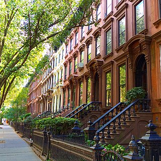
Park Slope is a neighborhood in northwestern Brooklyn, New York City, within the area once known as South Brooklyn. Park Slope is roughly bounded by Prospect Park and Prospect Park West to the east, Fourth Avenue to the west, Flatbush Avenue to the north, and Prospect Expressway to the south. Generally, the section from Flatbush Avenue to Garfield Place is considered the "North Slope", the section from 1st to 9th Street is considered the "Center Slope", and south from 9th Street, the "South Slope". The neighborhood takes its name from its location on the western slope of neighboring Prospect Park. Fifth Avenue and Seventh Avenue are its primary commercial streets, while its east–west side streets are lined with brownstones and apartment buildings.

Fiske Terrace is a planned community and neighborhood in the New York City borough of Brooklyn. Fiske Terrace is located in south central Brooklyn in the southern edge of the community of Flatbush and north of the community of Midwood. It is bounded by Glenwood Road on the north, Ocean Avenue on the east, the Bay Ridge Branch of the Long Island Rail Road/New York and Atlantic Railway right-of-way on the south, and the New York City Subway BMT Brighton Line subway line on the west.

<span class="mw-page-title-main">William Tubby</span> American architect

William Bunker Tubby was an American architect who was particularly notable for his work in New York City.

<span class="mw-page-title-main">Ditmas Park, Brooklyn</span> United States historic place

Ditmas Park is a historic district in the neighborhood of Flatbush in Brooklyn, New York City. The traditional boundaries of Ditmas Park, including Ditmas Park West, are Ocean Avenue and greater Flatbush to the east, Dorchester Road and the Prospect Park South neighborhood to the north, Coney Island Avenue and the Kensington neighborhood to the west, and Newkirk Avenue to the south. The name Ditmas Park is often used a shorthand for the several neighborhoods that comprise the larger area of Victorian Flatbush.

<span class="mw-page-title-main">National Register of Historic Places listings in Virginia</span>

Buildings, sites, districts, and objects in Virginia listed on the National Register of Historic Places:

<span class="mw-page-title-main">Prospect Lefferts Gardens</span> Neighborhood of Brooklyn in New York City

Prospect Lefferts Gardens is a residential neighborhood in the Flatbush area of the New York City borough of Brooklyn. The community is bounded by Empire Boulevard to the north, Clarkson Avenue to the south, New York Avenue to the east, and Ocean Avenue/Prospect Park to the west. Prospect Lefferts Gardens was designated a New York City Landmark area in 1979 and called the Prospect Lefferts Gardens Historic District.

<span class="mw-page-title-main">Beverley Squares</span> Neighborhoods of Brooklyn in New York City

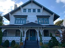
Beverley Square East and Beverley Square West, also spelled Beverly Square, are a pair of neighborhoods in the Flatbush section of the New York City borough of Brooklyn. Located southwest of Prospect Park within what is now called Victorian Flatbush, one of the largest concentrations of Victorian houses in the United States, they were developed in the 1900s primarily by Thomas Benton Ackerson, whose former home is in Beverley Square West.

<span class="mw-page-title-main">Lefferts Historic House</span>

The Lefferts Historic House is located within Prospect Park in Brooklyn, New York City. Built circa 1783, it is the former home of enslaved persons and the family of Continental Army Lieutenant Pieter Lefferts. It currently operates as a museum of the Leffertses' family life in Kings County. The museum is part of the Historic House Trust, owned by the New York City Department of Parks and Recreation and operated by the Prospect Park Alliance. It is a New York City designated landmark.

<span class="mw-page-title-main">C. P. H. Gilbert</span> American architect (1861–1952)

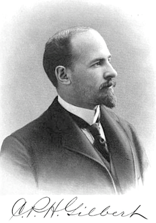
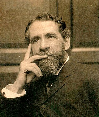
Charles Pierrepont Henry Gilbert was an American architect of the late-19th and early-20th centuries best known for designing townhouses and mansions.

<span class="mw-page-title-main">Flatbush Reformed Dutch Church Complex</span> United States historic place

The Flatbush Reformed Protestant Dutch Church, also known as the Flatbush Reformed Church, is a historic Dutch Reformed church – now a member of the Reformed Church in America – at 890 Flatbush Avenue in the Flatbush neighborhood of Brooklyn, New York City. The church complex consists of the church, cemetery, parsonage and church house.

<span class="mw-page-title-main">Buildings at 375–379 Flatbush Avenue and 185–187 Sterling Place</span> Historic commercial building in New York, United States

The buildings at 375–379 Flatbush Avenue and 185–187 Sterling Place are a historic group of four commercial and residential buildings located in the Prospect Heights neighborhood of Brooklyn, New York City. They were built in 1885 and are in the Neo-Grec style with Second Empire elements. The 377–379 Flatbush Avenue building is a 3.5-story masonry structure with a commercial ground floor, apartments above, and a distinctive corner tower with pyramidal roof. It features a mansard roof. The 375 Flatbush Avenue building is a commercial/residential structure identical in form to 377–379 Flatbush Avenue, but without a mansard roof. The 185–187 Sterling Place buildings are two single family row houses built as companions to the other buildings.

<span class="mw-page-title-main">Albemarle–Kenmore Terraces Historic District</span> Historic district in Brooklyn, New York

The Albemarle–Kenmore Terraces Historic District is a small historic district located in the Flatbush neighborhood of Brooklyn, New York City. It consists of two short cul-de-sacs, Albemarle Terrace and Kenmore Terrace, off of East 21st Street, and the 32 houses on the two streets, as well as a four-family apartment building at the end of Albemarle Terrace. The New York City Landmarks Preservation Commission, which designated the district as a landmark in 1978, noted that the "terraces are distinguished by the uniform use of materials, height and color producing a harmonious effect".

This is a timeline and chronology of the history of Brooklyn, New York. Brooklyn is the most populous of New York City's boroughs, and was settled in 1646.

<span class="mw-page-title-main">Victorian Flatbush</span> Neighborhood of Brooklyn in New York City

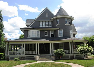
Victorian Flatbush is the western section of the Flatbush section of Brooklyn, New York, bordering Midwood, that is characterized by Victorian houses.

<span class="mw-page-title-main">John Y. Culyer</span> American architect

John Yapp Culyer was an American civil engineer, landscape architect, and architect, who worked on parks in Chicago, Pittsburgh and other cities. He is known as the Chief Landscape Engineer of Prospect Park opened in 1867.

<span class="mw-page-title-main">Kirby, Petit & Green</span>

Kirby, Petit & Green was an American architectural firm practicing in New York City, noted as the architects of Coney Island's Dreamland, among other major commissions. The three principals were architects Henry P. Kirby, John J. Petit, and James C. Green.

<span class="mw-page-title-main">Flatbush Malls</span> Traffic medians in Brooklyn, New York

The Flatbush Malls are a series of tree-lined landscaped medians along several roads in the Victorian Flatbush neighborhood of Brooklyn, New York City. An architecture critic has written that the malls "give the streets an uncommon spaciousness, if not grandeur". The first series was built in the northern part of the neighborhood along Albemarle Road, and extending one block north on Buckingham Road, in the Prospect Park South development of 1899, east of Coney Island Avenue and west of the BMT Brighton Line. This was modeled by the Scottish landscape architect John Aiken on Commonwealth Avenue Mall in Boston, with a design that originally included shrubbery but not trees, and in turn likely inspired the other neighborhood series. The second series, also known as the Midwood Malls, was built in the southern part of the neighborhood along both Glenwood Road, east of Coney Island Avenue and west of Delamere Place, as well as the intersecting East 17th Street, north of the Long Island Railroad cut of the Bay Ridge Branch and south of Foster Avenue, in the Fiske Terrace-Midwood Park developments of 1905.

<span class="mw-page-title-main">Willink Plaza</span> Intersection in Brooklyn, New York City

The Willink Entrance area, also known as Willink Plaza, is a major urban square of Brooklyn, New York City, formed by the intersection of Flatbush Avenue, Ocean Avenue and Empire Boulevard, at the eastern corner of Prospect Park and the southern corner of the Brooklyn Botanic Garden. It is serviced by the New York City Subway's Prospect Park station, and features several public spaces and historic buildings. This location is considered the northwestern point of the Prospect Lefferts Gardens neighborhood of Flatbush, and adjoins Crown Heights to its northeast.

Dean Alvord was an American real estate developer, college professor, and philanthropist known for his real estate developments in the New York City Metropolitan Area and in Florida. He was a relative of both Johnathan Edwards and Aaron Burr.

References

Notes

  1. 1 2 "National Register Information System". National Register of Historic Places . National Park Service. July 9, 2010.
  2. 1 2 3 4 5 6 7 8 9 New York City Landmarks Preservation Commission; Dolkart, Andrew S.; Postal, Matthew A. (2009). Postal, Matthew A. (ed.). Guide to New York City Landmarks (4th ed.). New York: John Wiley & Sons. pp. 263–64. ISBN   978-0-470-28963-1.
  3. New York City Landmarks Preservation Commission "Prospect Park South Historic District Map"
  4. 70th Precinct, NYPD.
  5. Gunnison, pp.86-92
  6. 1 2 3 4 5 6 7 8 9 10 11 12 13 14 15 16 White, Norval; Willensky, Elliot; Leadon, Fran (2010). AIA Guide to New York City (5th ed.). New York: Oxford University Press. pp. 713–715. ISBN   978-0-19538-386-7.
  7. Gunnison, pp.21-23
  8. Garvin, Alexander. The American City: What Works, What Doesn't (McGraw-Hill Professional, 2002) pp. 308-310
  9. 1 2 3 4 5 6 7 New York City Landmark Preservation Commission "Prospect Park South Historic District Designation Report" Archived March 26, 2013, at the Wayback Machine (February 8, 1979)
  10. Gray, Christopher (June 22, 2008). "Brooklyn's Stately Esplanade". The New York Times. ISSN   0362-4331 . Retrieved December 16, 2020.
  11. Staff (November 13, 1972). "Albanians Open a Mosque Here". The New York Times .
  12. Coltin, Jeff (September 2, 2020). "Five things to know about Maya Wiley". City & State NY. Archived from the original on September 3, 2020.
  13. Coltin, Jeff (November 1, 2020). "Is Maya Wiley the woman for NYC?". City & State NY. Archived from the original on November 2, 2020.
  14. White, Norval and Willensky, Elliot. AIA Guide to New York City (3rd ed.), pp.698-700
  15. "55 Parade Place"

Bibliography