Gerritsen Beach, Brooklyn

Last updated
The Plumb Beach Channel in Gerritsen Beach ICY-GerritsenBay.JPG
The Plumb Beach Channel in Gerritsen Beach

Gerritsen Beach is a neighborhood in the New York City borough of Brooklyn, located between Sheepshead Bay to the west and Marine Park to the east. [1] The area is served by Brooklyn Community Board 15. [2] The population of the neighborhood is 4,797 as of the 2020 U.S. census.

Contents

History

Gerritsen Beach, Brooklyn
Location in New York City
Gerritsen Avenue without bike lanes Gerritsen Ave 021.jpg
Gerritsen Avenue without bike lanes
Cyclists on Gerritsen Avenue GerritsenBeach-End 005.jpg
Cyclists on Gerritsen Avenue
The beach just past the end of Gerritsen Avenue, called "The Point" by local residents GerritsenEnd.JPG
The beach just past the end of Gerritsen Avenue, called "The Point" by local residents

The neighborhood is named for Wolphert Gerretse, a Dutch settler, who, in the early seventeenth century, built a house and mill on Gerritsen Creek, which is now part of the nearby Marine Park neighborhood. [3] The three-hundred-year-old mill was destroyed by fire in 1931. The famous Whitney family owned property by the mill and built a mansion. The Mansion had horse stables, servant quarters, a carriage house, and a private race track. The Mansion was knocked down in 1936 for the Marine Park Building Developments but the carriage house was still left standing. The Carriage house was converted into a private home that is still standing today.

Until the early twentieth century, the area remained undeveloped except for a few squatters’ bungalows clustered at the foot of Gerritsen Avenue. In 1920, Realty Associates, a speculative real-estate builder, began constructing a middle-class summer resort there. The southwestern section of Gerritsen’s meadow was soon covered to one-story bungalows with peaked roofs and no backyards. The popularity of this venture spurred further growth. Some bungalow-owners made them suitable for year-round habitation; others built two-story houses with backyards; and, within a decade, there were fifteen hundred houses in Gerritsen Beach. After WWII, there were apartments for returning veterans and their families. They were located on the opposite side of Gerritsen Avenue in what is now park land. They were demolished around 1955 after all the residents had relocated.

Almost all homes in the Gerritsen Beach area were damaged and/or affected by seawater on October 29, 2012, from Hurricane Sandy due to its peninsula characteristics. Almost all of the residents did not leave the neighborhood before the flooding began. The flood waters reached a record 10–12 ft in some parts of the neighborhood. A bar from Deep Creek Marina, two miles away, floated into the neighborhood, [4] with bottles and seating intact. [5] The damage was so severe that it led Mayor Michael Bloomberg to reclassify Gerritsen Beach as being in a Zone A flood zone.

Geography

Gerritsen Beach lies on a peninsula in the southeastern part of Brooklyn, south of the neighborhood of Marine Park and west of the eponymous park. [3] It is bounded on the north by Midwood at Avenue U, to the east by Marine Park at Gerritsen Avenue, to the south by Plumb Beach and the Plumb Beach Channel, and to the west by Sheepshead Bay at Shell Bank Creek and Knapp Street. [1]

It is bisected, from west to east, by the Gotham Avenue Canal. The area north of the canal, known as the "new section" by local residents, has traditional city streets lined with stores, brick houses, and wide sidewalks. The area south of the canal (the "old section") is a popular spot for party and chartered fishing boat berths. The typical size of the land lots in the community are 40 by 45 feet (12.19 by 13.72 m) in the old section, 34 by 52 feet (10.36 by 15.85 m) in the new section, and 24 by 70 feet (7.32 by 21.34 m) on the waterfront. [1] The streets in Gerritsen Beach are in alphabetical order (that is, Aster, Bevy, Celeste, Dictum, etc.).

Community

The neighborhood has a large Irish-Catholic presence in the community. A few long-standing residents of Irish descent refer to the community as being cois fharraige, which is an Irish language phrase meaning "by the sea". The remaining percentage of the population is predominantly of Scandinavian, Italian and German descent.

Education

The neighborhood is the location of the New York City Department of Education's Public School 277, an elementary school known as the Gerritsen Beach School. Brooklyn Blue-Feather School, 2335 Gerritsen Ave. is for special-needs children operates in the former Resurrection school building.

The Brooklyn Public Library's Gerritsen Beach branch is located at 2808 Gerritsen Avenue. The library has been operating since the 1950s, though it moved to its current location, a 10,000-square-foot (930 m2) structure, in 1997. [6]

Recreation

The Gerritsen Ballfields, consisting of three baseball fields, two athletic fields for soccer or football, and one Little League field, are located on the east side of Gerritsen Avenue, in addition to a "mini-airport" for motorized model airplanes located at Seba Avenue and Gerritsen Avenue. In 1993, this site benefited from a $192,000 renovation sponsored by Borough Council Member Herbert E. Berman. Also, recreational fishing is very popular with citizens of the community, as anglers are found fishing along the shore at the southern end of Gerritsen Avenue and along the adjacent shoreline of the Gerritsen Creek-Marine Park "salt marsh". The Gerritsen Creek estuary and the adjacent salt marsh is also a major spawning ground for various species of marine fish. Although riding quads is popular at this park, the activity is illegal everywhere in New York City and is destructive to the park's fragile ecosystem.

Police and crime

Gerritsen Beach is patrolled by the 61st Precinct of the NYPD, located at 2575 Coney Island Avenue. [7] The 61st Precinct ranked 5th safest out of 69 patrol areas for per-capita crime in 2010. [8]

The 61st Precinct has a lower crime rate than in the 1990s, with crimes across all categories having decreased by 88.2% between 1990 and 2018. The precinct reported 1 murder, 17 rapes, 150 robberies, 170 felony assaults, 169 burglaries, 584 grand larcenies, and 72 grand larcenies auto in 2018. [9]

Fire safety

New York City Fire Department

Gerritsen Beach is served by the New York City Fire Department (FDNY)'s Engine Co. 321/Foam 321/Brush Fire Unit 6, located at 2165 Gerritsen Avenue. [10] [11]

Volunteer Fire Department

Gerrittsen Beach Fire Department Vehicles Gerrittsen Beach Fire Department.jpg
Gerrittsen Beach Fire Department Vehicles

The local Volunteer Fire Department (a.k.a. "the Vollies"), the last remaining volunteer fire department in Brooklyn, was organized in 1922 when Gerritsen Beach was a small summer-resort community. The name of the department is officially spelled Gerrittsen Beach Fire Department [ sic ]. In 1921, a damaging fire on Abbey Court demonstrated to the community that the city’s regular fire apparatus could not reach the beach in time to put out a fire. A mass meeting was called by the residents, and that resulted in the organization of the only volunteer fire department in Brooklyn.

Before the city added water mains under Gerritsen Beach streets, the Volunteers had to handle fires at least three times a week. The danger posed to Gerritsen Beach residents by fire was especially acute because most families relied on oil stoves and kerosene lamps, and the water to fight fires had to be pumped from wells. The city did not build Engine Company 321's firehouse at Gerritsen Avenue and Avenue U until October 4, 1930.

Members of the fire brigade, currently known as the Vollies, were, in earlier times, nicknamed "the Vamps". Members are not only trained to fight fires, but also to rescue people who are drowning and to assist in other medical emergencies. According to the Vollies 1976 anniversary booklet, the Vollies were approved by the New York State Department of Health as an Emergency Services Training Center. Although the community is now served by Engine Company 321, strong support for the "Vollies" continues.

The following historical events involved the Gerritsen Beach volunteers in actions outside their own neighborhood:

The Gerritsen Beach Volunteer Fire Department has one fire engine, two ambulances, one brush fire unit and a fly car.

In film

Notable people

Related Research Articles

<span class="mw-page-title-main">New York City Fire Department</span> Fire department in New York City

The New York City Fire Department, officially the Fire Department of the City of New York (FDNY) is the full-service fire department of New York City, serving all five boroughs. The FDNY is responsible for fire suppression and fire prevention, and is a major provider of EMS services in New York City. Beyond fire suppression and EMS, the FDNY is responsible for a broad range of services, including technical rescue, CBRN defense, and structural collapse response and analysis. The FDNY is equipped with a wide variety of general-purpose and specialized fire apparatus to serve its varied missions.

<span class="mw-page-title-main">Flatlands, Brooklyn</span> Neighborhood of Brooklyn in New York City

Flatlands is a neighborhood in the southeast part of the borough of Brooklyn in New York City. The current neighborhood borders are roughly defined by the Bay Ridge Branch to the north, Avenue U to the south, Ralph Avenue to the east, and Flatbush Avenue to the southwest.

<span class="mw-page-title-main">Midland Beach, Staten Island</span> Neighborhood of Staten Island in New York City

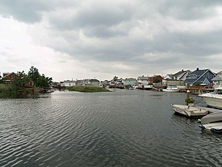
Midland Beach is a neighborhood of Staten Island in New York City. It lies along the east-central coast of the island, in the area known locally as the "Mid-Island, Staten Island" or the "East Shore".

<span class="mw-page-title-main">Howard Beach, Queens</span> Neighborhood of Queens in New York City

Howard Beach is a neighborhood in the southwestern portion of the New York City borough of Queens. It is bordered to the north by the Belt Parkway and Conduit Avenue in Ozone Park, to the south by Jamaica Bay in Broad Channel, to the east by 102nd–104th Streets in South Ozone Park, and to the west by 75th Street in East New York, Brooklyn. The area consists mostly of low-rise single-family houses.

<span class="mw-page-title-main">Sheepshead Bay, Brooklyn</span> Neighborhood of Brooklyn in New York City

Sheepshead Bay is a neighborhood in southern Brooklyn, New York City. It is bounded by Ocean Parkway to the west; Avenue T and Kings Highway to the north; Nostrand Avenue and Gerritsen Avenue to the east; and the Atlantic Ocean to the south. Sheepshead Bay is abutted by the neighborhoods of Brighton Beach and Homecrest to the west; Midwood to the north; and Gerritsen Beach to the east.

<span class="mw-page-title-main">Manhattan Beach, Brooklyn</span> Neighborhood of Brooklyn in New York City

Manhattan Beach is a residential neighborhood in the New York City borough of Brooklyn. It is bounded by the Atlantic Ocean to the south and east, by Sheepshead Bay on the north, and Brighton Beach to the west. Traditionally known as an Italian and Ashkenazi Jewish neighborhood, it is also home to a sizable community of Sephardi Jews and a large Russian Jewish immigrant presence.

<span class="mw-page-title-main">Broad Channel, Queens</span> Neighborhood of Queens in New York City

Broad Channel is a neighborhood in the southern portion of the New York City borough of Queens. It occupies the southern portion of Rulers Bar Hassock, the only inhabited island in Jamaica Bay.

<span class="mw-page-title-main">Prospect Heights, Brooklyn</span> Neighborhood of Brooklyn in New York City

Prospect Heights is a neighborhood in the northwest of the New York City borough of Brooklyn. The traditional boundaries are Flatbush Avenue to the west, Atlantic Avenue to the north, Eastern Parkway – beginning at Grand Army Plaza – to the south, and Washington Avenue to the east. In the northern section of Prospect Heights are the Vanderbilt Rail Yards, built over as part of the Pacific Park project. The Barclays Center, home to the NBA's Brooklyn Nets basketball team, is located in the northwestern corner of the neighborhood in Pacific Park at Flatbush and Atlantic Avenues.

<span class="mw-page-title-main">Tremont, Bronx</span> Neighborhood of the Bronx in New York City

Tremont is a residential neighborhood in the West Bronx, New York City. Its boundaries are East 181st Street to the north, Third Avenue to the east, the Cross-Bronx Expressway to the south, and the Grand Concourse to the west. East Tremont Avenue is the primary thoroughfare through Tremont.

<span class="mw-page-title-main">Maspeth, Queens</span> Neighborhood of Queens in New York City

Maspeth is a residential and commercial community in the borough of Queens in New York City. It was founded in the early 17th century by Dutch and English settlers. Neighborhoods sharing borders with Maspeth are Woodside to the north; Sunnyside to the northwest; Greenpoint, Brooklyn to the west; East Williamsburg, Brooklyn to the southwest; Fresh Pond and Ridgewood to the south; and Middle Village and Elmhurst to the east.

<span class="mw-page-title-main">Dongan Hills, Staten Island</span> Neighborhood of Staten Island in New York City

Dongan Hills is a neighborhood located within the New York City borough of Staten Island. It is on the Island's East Shore. Dongan Hills is bounded by Laconia Avenue on the southeast, Jefferson Avenue on the southwest, Richmond Road on the northwest, and Old Town Road to the north. It is adjacent to New Dorp and Grant City to the southwest, Todt Hill to the northwest, Old Town/Concord to the northeast, and South Beach and Midland Beach to the southeast.

<span class="mw-page-title-main">Glendale, Queens</span> Neighborhoods of Queens in New York City

Glendale is a neighborhood in the west-central portion of the New York City borough of Queens. It is bounded by Forest Hills to the east, Ridgewood to the west, Woodhaven to the south, and Middle Village to the north.

<span class="mw-page-title-main">Country Club, Bronx</span> Neighborhood of the Bronx in New York City

Country Club is a residential neighborhood located in the East Bronx in New York City. The neighborhood's boundaries are Middletown Road and Watt Avenue to the north, Eastchester Bay to the east, Layton Avenue and the Throggs Neck neighborhood to the south, and the New England Thruway and Pelham Bay neighborhood to the west. Pelham Bay Park, the largest public park in New York City, is located just north of Country Club.

Brooklyn Community Board 15 is a New York City community board that encompasses the Brooklyn neighborhoods of Gravesend, Sheepshead Bay, Manhattan Beach, Gerritsen Beach, Madison, Homecrest, and Plum Beach. It is delimited by Corbin Place, Coney Island Avenue, Avenue Y, 86th street, Avenue U and McDonald Avenue, Avenue P and Kings Highway on the north, Nostrand avenue and Marine Park on the east, as well as by the Atlantic Ocean on the south.

<span class="mw-page-title-main">Marine Park (neighborhood), Brooklyn</span> Neighborhood in Brooklyn, New York City

Marine Park is a neighborhood in the New York City borough of Brooklyn. The neighborhood lies between Flatlands and Mill Basin to the east, and Gerritsen Beach, Midwood, and Sheepshead Bay to the south and west. It is mostly squared off in area by Gerritsen Avenue, Flatbush Avenue, Avenue U and Kings Highway. The neighborhood's eponymous park is the largest public park in Brooklyn. Charles Downing Lay won a silver medal in town planning at the 1936 Olympics for the planning of Marine Park.

The New York City Fire Department in the United States, like most fire departments around the world, is organized in a paramilitary fashion. Its organizational structure includes regional commands for various geographic areas within its jurisdiction, operational commands for units of different functions, and administrative units and offices for various administrative functions.

<span class="mw-page-title-main">South Ozone Park, Queens</span> Neighborhood of Queens in New York City

South Ozone Park is a neighborhood in the southwestern section of the New York City borough of Queens. It is just north of John F. Kennedy International Airport, between Aqueduct Racetrack to the west and the Van Wyck Expressway to the east. Adjacent neighborhoods include Ozone Park to the west; Richmond Hill to the north; Jamaica, South Jamaica, and Springfield Gardens to the east; and Howard Beach and Old Howard Beach to the southwest.

<span class="mw-page-title-main">Homecrest, Brooklyn</span> Neighborhood of Brooklyn in New York City

Homecrest is a neighborhood situated in the New York City borough of Brooklyn, sometimes considered as part of Sheepshead Bay. It is bordered by Kings Highway to the north, Avenue X to the south, Coney Island Avenue to the west, and Ocean Avenue to the east.

<span class="mw-page-title-main">Prospect Lefferts Gardens</span> Neighborhood of Brooklyn in New York City

Prospect Lefferts Gardens is a residential neighborhood in the Flatbush area of the New York City borough of Brooklyn. The community is bounded by Empire Boulevard to the north, Clarkson Avenue to the south, New York Avenue to the east, and Ocean Avenue/Prospect Park to the west. Prospect Lefferts Gardens was designated a New York City Landmark area in 1979 and called the Prospect Lefferts Gardens Historic District.

References

  1. 1 2 3 Mooney, Jake. "The Art of Hiding in Plain Sight," The New York Times, Sunday, August 19, 2012.
  2. Brooklyn Community Boards Archived 2007-12-21 at the Wayback Machine , New York City. express bus. Accessed December 31, 2007.
  3. 1 2 Cohen, Joyce. "If You're Thinking of Living In/Gerritsen Beach; Secluded Peninsula in South Brooklyn", The New York Times , March 3, 2002. Accessed November 11, 2007. "The area, named for Wolfert Gerritsen, a 17th-century settler, was mostly marshland until around 1920, when a company called Realty Associates began building summer homes."
  4. Johnston, Garth (Nov 6, 2012). "Sandy's Bar: Watering Hole Floated Into Gerritsen Beach!". Gothamist. Archived from the original on 2013-12-17.
  5. "The Neighborhood News," New York magazine, Nov. 19, 2012, p. 10
  6. "Gerritsen Beach Library". Brooklyn Public Library. August 19, 2011. Retrieved February 21, 2019.
  7. "NYPD – 61st Precinct". www.nyc.gov. New York City Police Department . Retrieved October 3, 2016.
  8. "Sheepshead Bay – DNAinfo.com Crime and Safety Report". www.dnainfo.com. Archived from the original on April 15, 2017. Retrieved October 6, 2016.
  9. "61st Precinct CompStat Report" (PDF). www.nyc.gov. New York City Police Department . Retrieved July 22, 2018.
  10. "Engine Company 321/Foam 321". FDNYtrucks.com. Retrieved March 2, 2019.
  11. "FDNY Firehouse Listing – Location of Firehouses and companies". NYC Open Data; Socrata . New York City Fire Department. September 10, 2018. Retrieved March 14, 2019.
  12. Gershman, Jacob; Fleisher, Lisa (December 29, 2010). "30 Hours' Wait for Ambulance".
  13. Locations Search for Bartlett Place, Gerritsen Beach (IMDb)
  14. NYC.gov - Mayor's Office of Film, Theatre & Broadcasting - Sets in the City Archived 2007-10-22 at the Wayback Machine
  15. Shaft (2000 remake); IMDb profile
  16. She's the One (1996); IMDb profile
  17. IMDb profile
  18. Hartman, Susan. "Brooklyn Boxer Rises, but Her Feet Stay on the Ground", The New York Times , April 4, 2014. Accessed February 4, 2021. "After years of struggle, Ms. Hardy is a rising force in professional boxing and has become a source of pride in Gerritsen Beach, the tightknit Brooklyn neighborhood where her family’s roots stretch back six generations."
  19. "Chapel Perilous: The Life and Thought Crimes of Robert Anton Wilson — An Interview with Prop Anon", Mondo 2000, November 13,2017. Accessed February 4, 2021. "Bob was born in Flatbush, Brooklyn and spent his childhood in one of its most remote neighborhoods, Gerritsen Beach. He described the one-road-town as an 'Irish Catholic Ghetto,' as he grew up a prodigious youth who survived two bouts of Polio, child abuse at the hands of the nuns who ran his grammar school, and a narrow-minded working-class neighborhood."

40°35′29″N73°55′36″W / 40.59139°N 73.92667°W / 40.59139; -73.92667