
The Niut Range is 3600 km2 in area. It is a subrange of the Pacific Ranges of the Coast Mountains of British Columbia, although in some classifications it is considered part of the Chilcotin Ranges. The Niut is located in the angle of the Homathko River and its main west fork, Mosley Creek. It is isolated, island-like, by those rivers from its neighbour ranges, as both streams have their source on the Chilcotin Plateau in behind the range. Razorback Mountain is its highest peak.

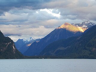
Bute Inlet is one of the principal inlets of the British Columbia Coast. It is 80 km (50 mi) long from the estuaries of the Homathko and Southgate Rivers at the head of the inlet, to the mouth, where it is nearly blocked by Stuart Island, and it averages about 4 km (2.5 mi) in width. Bute Inlet is in a spectacular wilderness setting and is one of the most scenic waterways in the world. In the upper reaches of the inlet mountains rise 2,700 m (9,000 ft) feet above sea level. Bute Inlet is a spectacular wilderness that is visited by very few people. In more recent years tourists are travelling from around the world to view grizzly bears in a natural setting and explore the wilderness of Bute Inlet.
Babine River Corridor Provincial Park is a provincial park in British Columbia, Canada, located to the north of Hazelton. The park was established by Order-in-Council in 1999 and is approximately 15,339 hectares in area.

Copeland Islands Marine Provincial Park is a provincial park in British Columbia, Canada, located in Desolation Sound to the northwest of Lund on the northern Sunshine Coast off the west coast of the Malaspina Peninsula.

Fossli Provincial Park is a provincial park in British Columbia, Canada, located on Stirling Arm of Sproat Lake on Vancouver Island. The 52-hectare park, west of Port Alberni, is accessible by water or private logging road. It has few services, but has a 30-minute hiking trail to an old homestead site. The homestead belonged to Helen and Armour Ford, who donated the land for the park to the province in 1974. Saint Andrew's Creek runs through the park, and is a fall spawning ground for coho salmon.
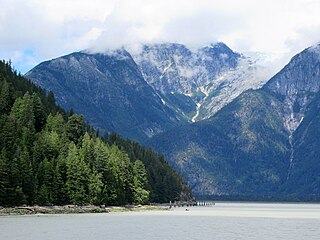
Homathko Estuary Provincial Park is a provincial park in British Columbia, Canada, located at the head of Bute Inlet surrounding the mouth of the Homathko River in the Pacific Ranges of the Coast Mountains.

Little Qualicum Falls Provincial Park is a provincial park in British Columbia, Canada, on central Vancouver Island, that encompasses the entire southern shore of Cameron Lake. The Island Rail Corridor line to Port Alberni passes through the park.
Nimpkish Lake Provincial Park is a provincial park on northern Vancouver Island, British Columbia, Canada on Vancouver Island. The park is 3,949 ha. in area and was established on 1995. It is 32 km south of Port McNeill and on the southwest side of Nimpkish Lake. Primary access is by boat launch, though radio-controlled logging roads lead to the edge of the park. Western Forest Products in Woss, British Columbia should be contacted for road advisories. The park is in the traditional territory of the Namgis First Nation.
Okeover Arm Provincial Park is a provincial park in British Columbia, Canada, located on the west side of Okeover Inlet facing Desolation Sound, on the east side of the Malaspina Peninsula.
Prophet River Hot Springs Provincial Park is a provincial park in British Columbia, Canada. Established high in the Muskwa Ranges, on the course of the Prophet River, it is part of the larger Muskwa-Kechika Management Area.
Scatter River Old Growth Provincial Park is a provincial park in British Columbia, Canada, located on the Liard River downstream from Liard River Hot Springs Provincial Park and Liard River Corridor Provincial Park and Protected Area. The park includes the Grand Canyon of the Liard, a 30 km stretch of canyon and whitewater between the Toad and Trout River converges with the Liard. The park includes high upland plateau and muskeg as well as stands of old growth spruce forests. Established in 1999, the park is c.1140 ha. in area.

Stamp River Provincial Park is a provincial park in British Columbia, Canada. The 327-hectare park is located 14 km north of Port Alberni on Vancouver Island. There are 23 camping spaces and 2 km of trails within the park along the Stamp River, named for Edward Stamp, a sawmill pioneer in the Alberni Valley.
Stuart River Provincial Park is a provincial park in British Columbia, Canada. It is located in two sections north and northwest of Vanderhoof along the Stuart River southeast of Stuart Lake and the city of Fort St. James. The upper section is located at 54°13′20″N124°00′00″W and comprises c.7391 ha. while the lower, eastern section is centred at 54°03′00″N123°37′00″W and comprises c.3390 ha. and is within the Greater Prince George area. The upper site, which is located around the confluence of the Stuart and Nechako Rivers, includes the site of Chinlac, a Dakelh village whose inhabitants were massacred and enslaved by the Tsilhqot'in of Anahim Lake c. 1745.
Teakerne Arm Provincial Park is a provincial park in British Columbia, Canada, located on the north shore of Teakerne Arm on West Redonda Island in the Discovery Islands archipelago, to the northeast of the city of Campbell River, Canada.
Winter Harbour is the western-most settlement on the west coast about 41 kilometres (25 mi) from the northwest tip of Vancouver Island, British Columbia. This unincorporated community on Winter Harbour is on the northern side of Quatsino Sound at the mouth.
The Lillooet Icecap, also called the Lillooet Icefield or the Lillooet Crown, is a large icefield in the Pacific Ranges of the Coast Mountains in southwestern British Columbia, Canada. It is about 90 km (56 mi) northwest of the towns of Pemberton and Whistler, and about 175 km (109 mi) north of Vancouver, British Columbia. The Lillooet Icecap is one of the largest of several large icefields in the Pacific Ranges which are the largest temperate-latitude glacial fields in the world. At its maximum extent including its glacial tongues it measures 30 km (19 mi) east to west and 20 km (12 mi) north to south; its central icefield area is approximately 15 km (9 mi) in diameter.
The Southgate River is a river in the Pacific Ranges of the Coast Mountains in British Columbia, Canada, entering the head of Bute Inlet, on that province's South Coast, just east of the mouth of the Homathko River at Waddington Harbour. The lower reaches of the river's course are flat-bottomed and are named Pigeon Valley.
Mount Gilbert, 3124 m prominence: 484 m, is a mountain in the Pacific Ranges of the Coast Mountains of British Columbia, Canada. It is located south of the confluence of the Bishop and Southgate Rivers and to the west of the Compton Névé, a large icefield, and to the south of the Homathko Icefield, another large icefield.
Waddington Harbour is a harbour at the head of Bute Inlet in the Central Coast region of British Columbia, Canada. Also issuing into the head of Bute Inlet and Waddington Harbour, just east of the mouth of the Homathko, is the Teaquahan River. Issuing directly into the inlet a few miles south on the harbour's southeast is the Southgate River, one of the major rivers of the central Pacific Ranges, which begins on the west side of the Lillooet Icecap. Its lower valley adjacent to the inlet's shores is called Pigeon Valley.
The Bishop River is a river in the Pacific Ranges of the Coast Mountains, flowing west from the western edge of the Lillooet Icecap to join the Southgate River east of the Homathko Icefield. Bishop River Provincial Park surrounds the upper course of the river, from the source at the Lillooet Icecap to midway along its course above its confluence with the Southgate.
