
Stuart Lake, or Nak'albun in the Carrier (Dakelh) language is a lake situated in the Northern Interior of British Columbia, Canada. The town of Fort St. James is situated by the lake near the outlet. Stuart Lake is 66 kilometres (41 mi) long, 10 kilometres (6.2 mi) wide and relatively shallow, with an average depth of 26 metres (85 ft). There are several privately owned islands on Stuart lake.

Dunvegan Provincial Park and Historic Dunvegan are a provincial park and a provincial historic site of Alberta located together on one site. They are located in Dunvegan, at the crossing of Peace River and Highway 2, between Rycroft and Fairview.

Fort Fraser is an unincorporated village of about 500 people, situated near the base of Fraser Mountain, close to the village municipality of Fraser Lake and the Nechako River. It can be found near the geographical centre of British Columbia, Canada, 44 km (27 mi) west of Vanderhoof on the Yellowhead Highway. Originally established in 1806 as a North West Company fur trading post by the explorer Simon Fraser, it is one of present-day British Columbia's oldest permanent European-founded settlements. The area around the community is also recorded as the site of the first land in British Columbia cultivated by non-First Nations people.
Liard River Hot Springs Provincial Park is a provincial park in British Columbia, Canada. It is home to the second largest natural hot springs in Canada, after Deer River Hot Springs 15 km to the north east. It is a natural river of hot water rather than a spring fed man made pool. The park is part of the larger Muskwa-Kechika Management Area. The community of Liard River, British Columbia is located nearby.
French Beach Provincial Park is a provincial park in British Columbia, Canada.

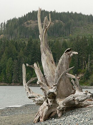
Juan de Fuca Provincial Park is a provincial park located on the west coast of Vancouver Island in British Columbia, Canada. The park was established on April 4, 1996 by combining three former parks - China Beach, Loss Creek, and Botanical Beach - into one provincial park. It is the location of the majority of the Juan de Fuca Marine Trail, which is a southern compliment to the West Coast Trail within Pacific Rim National Park Reserve.
Mount Pope Provincial Park is a provincial park in British Columbia, Canada, located 7km northwest of Fort St. James in the Omineca Country region of that province's Central Interior. Mount Pope is about 1420 meters high and composed of limestone. The trail to the summit from Stones Bay Road gains about 700m and may be followed year-round. There are a few dozen developed rock climbs up to seven pitches long on the lower flanks of the mountain.
Mudzenchoot Provincial Park is a provincial park in British Columbia, Canada, located 90 km (56 mi) northwest of Fort St. James in the Omineca Country of British Columbia's Central Interior. It is at a high elevation and is characterized by dry meadows including unique vegetation such as erigerons, aster type species, and cotton grass. The provincial park has zero facilities or road access points.
Sowchea Bay Provincial Park is a provincial park in central British Columbia, Canada. It is on Stuart Lake, west of Prince George. The park is 13 hectares in area. It is a busy destination for boaters and anglers, with a single-lane concrete boat launch available with limited parking.
Sproat Lake Provincial Park is a provincial park near Port Alberni in British Columbia, Canada's Vancouver Island. Its name derives from a lake named after 19th century entrepreneur and colonial official Gilbert Malcolm Sproat.
Stuart River Provincial Park is a provincial park in British Columbia, Canada. It is located in two sections north and northwest of Vanderhoof along the Stuart River southeast of Stuart Lake and the city of Fort St. James. The upper section is located at 54°13′20″N124°00′00″W and comprises c.7391 ha. while the lower, eastern section is centred at 54°03′00″N123°37′00″W and comprises c.3390 ha. and is within the Greater Prince George area. The upper site, which is located around the confluence of the Stuart and Nechako Rivers, includes the site of Chinlac, a Dakelh village whose inhabitants were massacred and enslaved by the Tsilhqot'in of Anahim Lake c. 1745.
Errington is a small community on Vancouver Island, British Columbia, Canada, located on Errington Road, off Highway 4, just south of Parksville and Qualicum Beach.
Nyan Wheti is an ancient land route in northern British Columbia, Canada from the Dakelh villages on Fraser Lake (Nadlehbunk'ut) to villages on Stuart Lake (Nak'albun), about 50 km to the north. The name in Carrier means "The Way Across."

Ocean Park is a neighbourhood of South Surrey, a region of Surrey, British Columbia.
Murray Ridge Ski Area, also known as Murray Ridge Ski Hill, is a small ski resort located near Fort St. James, British Columbia, Canada. The area has been in operation since the 1976-77 ski season and is managed by the Fort St. James Ski Club. The facilities include a 557 m² day lodge. The area's T-Bar is reputed to be the longest in the world. Development of the area, which began with only two rope-tows, was assisted by Al Raine.
The Nation Lakes are a series of four lakes in the Nation River system of the Omineca Country of the Central Interior of British Columbia, Canada. The four lakes are, from west to east (downstream), Tsayta, Indata, Tchentlo, and Chuchi Lakes. Nation Lakes Park was established in 2004 as a result of the Fort St. James Land Resource Management Plan and is a popular canoeing destination.
Horneline Creek Provincial Park is a provincial park in far northern British Columbia, Canada. It is located west of the Kechika River about 130 km south of Lower Post and 30 km north of Denetiah Provincial Park and southwest of the community of Liard River.
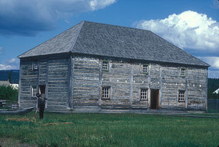
Fort St. James is a district municipality and former fur trading post in northern central British Columbia, Canada. It is located on the south-eastern shore of Stuart Lake in the Omineca Country, at the northern terminus of Highway 27, which connects to Highway 16 at Vanderhoof.
Lejac is a locality on the Canadian National Railway line in the Nechako Country region of British Columbia, located on the south shore of Fraser Lake between the communities of Fraser Lake (W) and Fort Fraser (E).
