
The Erie Canal is a historic canal in upstate New York that runs east–west between the Hudson River and Lake Erie. Completed in 1825, the canal was the first navigable waterway connecting the Atlantic Ocean to the Great Lakes, vastly reducing the costs of transporting people and goods across the Appalachians. In effect, the canal accelerated the settlement of the Great Lakes region, the westward expansion of the United States, and the economic ascendancy of New York State. It has been called "The Nation's First Superhighway."

The Niagara River is a river that flows north from Lake Erie to Lake Ontario. It forms part of the border between the province of Ontario in Canada and the state of New York in the United States. There are differing theories as to the origin of the river's name. According to Iroquoian scholar Bruce Trigger, Niagara is derived from the name given to a branch of the locally residing native Neutral Confederacy, who are described as being called the Niagagarega people on several late-17th-century French maps of the area. According to George R. Stewart, it comes from the name of an Iroquois town called Ongniaahra, meaning "point of land cut in two".
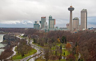
Niagara Falls is a city in Ontario, Canada. It is on the western bank of the Niagara River in the Golden Horseshoe region of Southern Ontario, with a population of 94,415 at the 2021 census. It is part of the St. Catharines - Niagara Census Metropolitan Area (CMA). Incorporated on 12 June 1903, the city is across the river from Niagara Falls, New York. The Niagara River flows over Niagara Falls at this location, creating a natural spectacle which attracts millions of tourists each year.

Fort Erie is a town on the Niagara River in Niagara Region, Ontario, Canada. It is directly across the river from Buffalo, New York, and is the site of Old Fort Erie which played a prominent role in the War of 1812.

The Regional Municipality of Niagara, also colloquially known as the Niagara Region or Region of Niagara, is a regional municipality comprising twelve municipalities of Southern Ontario, Canada. The regional seat is in Thorold. It is the southern end of the Golden Horseshoe, the largest megalopolis in Canada.

Queenston is a compact rural community and unincorporated place 5 kilometres (3.1 mi) north of Niagara Falls in the Town of Niagara-on-the-Lake, Ontario, Canada. It is bordered by Highway 405 to the south and the Niagara River to the east; its location at the eponymous Queenston Heights on the Niagara Escarpment led to the establishment of the Queenston Quarry in the area. Across the river and the Canada–US border is the village of Lewiston, New York. The Lewiston-Queenston Bridge links the two communities. This village is at the point where the Niagara River began eroding the Niagara Escarpment. During the ensuing 12,000 years the Falls cut an 11 kilometres (6.8 mi) long gorge in the Escarpment southward to its present-day position.
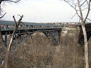
The Whirlpool Rapids Bridge, commonly known as the Whirlpool Bridge or the Lower Steel Arch Bridge, is a spandrel braced, riveted, two-hinged arch bridge that crosses the Canada–United States border, connecting the commercial downtown districts of Niagara Falls, Ontario, and Niagara Falls, New York. This bridge is located approximately 1.5 kilometres (0.9 mi) north of the Rainbow Bridge and about 2 kilometres (1.2 mi) from the Falls. It was acquired by the Niagara Falls Bridge Commission in January 1959. Immediately upstream is the similar arch-style Michigan Central Railway Bridge, which has been out of service since 2001.
The Buffalo and Niagara Falls Railroad was a part of the New York Central Railroad system, connecting Buffalo, New York to Niagara Falls. It is still used by CSX for freight and Amtrak for passenger service.

The International Railway Bridge is a two-span swing bridge carrying the Stamford Subdivision of the Canadian National Railway across the Niagara River between Fort Erie, Ontario, Canada, and Buffalo, New York, United States. It was originally built in 1873 for the International Bridge Company by Casimir Stanislaus Gzowski and D.L. MacPherson.
New York State Route 265 (NY 265) is a 19.75-mile (31.78 km) long state highway located in the western part of New York in the United States. NY 265 is a north–south route that roughly parallels the western parts of the Niagara River in Erie County and Niagara County. For much of its southern course, it is more frequently referred to by its longtime name, Military Road, which dates back to 1801 as a road to connect the city of Black Rock and Fort Niagara near Lake Ontario.
Transportation in New York is made up of some of the most extensive and one of the oldest transportation infrastructures in the country. Engineering difficulties because of the terrain of the State of New York and the unique issues of New York City brought on by urban crowding have had to be overcome since the state was young. Population expansion of the state generally followed the path of the early waterways, first the Hudson River and then the Erie Canal. Today, railroad lines and the New York State Thruway follow the same general route.

Buffalo is the county seat of Erie County, and the second most populous city in the U.S. state of New York, after New York City. Originating around 1789 as a small trading community inhabited by the Neutral Nation near the mouth of Buffalo Creek, the city, then a town, grew quickly after the opening of the Erie Canal in 1825, with the city at its western terminus. Its position at the eastern end of Lake Erie strengthened the economy, based on grain milling and steel production along the southern shores and in nearby Lackawanna.

The Niagara Falls Station and Customhouse Interpretive Center is an intermodal transit complex in Niagara Falls, New York. It serves Amtrak trains and Niagara Frontier Transportation Authority buses, houses U.S. Customs and Border Protection offices servicing the Canada–United States border, and houses the Niagara Falls Underground Railroad Heritage Center.

Scajaquada Creek is a stream in Erie County, New York, United States. The name is derived from Philip Kenjockety, a Native American described as the oldest resident of the region upon his death in 1808.

Canalside, formerly known as Canal Side and also referred to as Erie Canal Harbor, is a commercial and residential district in downtown Buffalo, New York. It is the recreation of the western terminus of the Erie Canal, which was destroyed in the early 20th century. Canalside is situated on the Buffalo River, in an area that was historically home to the Seneca people.

The Black Rock Lock is a ship lock in Buffalo, New York, that allows vessels to bypass rapids on the Niagara River at the outlet of Lake Erie. The lock chamber is 650 feet (200 m) long, 70 feet (21 m) wide, and rises 26 feet (7.9 m). The original lock at Black Rock was built in 1833 following the completion of the Erie Canal. The current, larger lock was completed in 1913.
The Black Rock Rail Yard is on the west side of Buffalo, New York, a half mile inland from the Niagara River, in the Black Rock neighborhood. The rail yard receives Canadian National Railway freight trains arriving from Canada by way of the International Railway Bridge.

Broderick Park is a park situated on Unity Island in the Niagara River in Buffalo, New York, United States. It was named for Michael Broderick, one of the founders of the West Side Rowing Club, which had a clubhouse on the southern point of Unity Island until 1975, when it was destroyed by fire.

Unity Island is an approximately 160-acre (0.65 km2) island separating the Niagara River and the Black Rock Canal, located within the city limits of Buffalo, New York. The historic island is home to two public parks and a water treatment facility. It is connected to the mainland by a two-span swing bridge.

Transportation in Buffalo, New York is dominated by automobile use, but other modes of transportation exist in the city.


