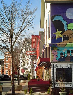
Inman Park is an intown neighborhood on the east side of Atlanta, Georgia, and its first planned suburb. It was named for Samuel M. Inman.

Chestnut Hill is a wealthy New England region located six miles (10 km) west of downtown Boston, Massachusetts, United States. Like all Massachusetts villages, Chestnut Hill is not an incorporated municipal entity. It is located partially in Brookline in Norfolk County; partially in the city of Boston in Suffolk County, and partially in the city of Newton in Middlesex County. Chestnut Hill's borders are defined by the 02467 ZIP Code. The name refers to several small hills that overlook the 135-acre Chestnut Hill Reservoir rather than one particular hill. Chestnut Hill is best known as the home of Boston College and as part of the Boston Marathon route.

Grant Park refers to the oldest city park in Atlanta, Georgia, United States, as well as the Victorian neighborhood surrounding it.

The Olmsted Brothers company was a landscape architectural firm in the United States, established in 1898 by brothers John Charles Olmsted (1852–1920) and Frederick Law Olmsted Jr. (1870–1957), sons of the landscape architect Frederick Law Olmsted.
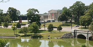
Delaware Park–Front Park System is a historic park system and national historic district in the northern and western sections of Buffalo in Erie County, New York. The park system was designed by Frederick Law Olmsted and Calvert Vaux and developed between 1868 and 1876.
The Upper West Side is a neighborhood in Buffalo, New York.

Riverside Park is a historic park located in the Riverside neighborhood in Buffalo, New York. Located in northwest Buffalo, it is an individual park designed by the Olmsted Architectural Firm in 1898 after Frederick Law Olmsted's retirement. It is on a 22-acre (8.9 ha) site on a bluff overlooking the Niagara River. Riverside Park was designed for active recreation and periodic alterations have occurred as the community's recreation needs have changed. Despite the changes, the park retains numerous original design elements and remains as the final element completed as a part of the Olmsted plan for Buffalo's park system.

West Village Historic District is a national historic district located at Buffalo in Erie County, New York. The district is a 19th-century residential neighborhood within walking distance of the central business district and Lake Erie. It is one of Buffalo's oldest and most intact residential areas, having been developed on the site of the estate of the city's first mayor Ebenezer Johnson and South Village of Black Rock. It contains 102 structures built between 1854 and 1914, most of which are detached single-family dwellings, with about a dozen apartment buildings. The district reflects architectural styles of the late 19th century including the Second Empire, Gothic Revival, and Italianate style. Included in the district is Johnson Park, redesigned by Frederick Law Olmsted about 1876, and Hutchinson Central Technical High School.
Parkside East Historic District is a national historic district located at Buffalo in Erie County, New York. The district is architecturally and historically significant for its association with the 1876 Parks and Parkways Plan for the city of Buffalo developed by Frederick Law Olmsted. It consists of 1,769 contributing structures developed from 1876 to 1936, as a middle class residential neighborhood. The district largely contains single-family dwellings, built in a variety of popular architectural styles, and located along the irregular and curvilinear street pattern developed by Olmsted. The district is located to the east of Buffalo's Delaware Park and includes the Walter V. Davidson House and the separately listed Darwin D. Martin House, both designed by Frank Lloyd Wright.

Parkside West Historic District is a national historic district located at Buffalo in Erie County, New York. The district is architecturally and historically significant for its association with the 1876 Parks and Parkways Plan for the city of Buffalo developed by Frederick Law Olmsted in 1876. It consists of 137 contributing structures developed primarily from 1923 to 1940, as a middle class residential neighborhood. The district largely contains single-family dwellings, built in a variety of popular architectural styles, and located along the irregular and curvilinear street pattern developed by Olmsted. They include homes along Nottingham Terrace and Middlesex Road, and segments of Meadow Road, Lincoln Parkway, Delaware Avenue, and Amherst Street. The district is located to the north of Buffalo's Delaware Park.
Cazenovia Park–South Park System is a historic park system located in the South Buffalo neighborhood at Buffalo in Erie County, New York. The interconnected set of parkways and parks was designed by Frederick Law Olmsted as part of his parks plan for the city of Buffalo, as inspired in large part by the parkland, boulevards, and squares of Paris, France.
The Delaware District is a neighborhood in Buffalo, New York.
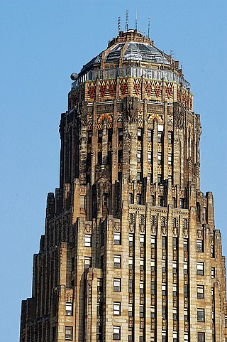
The Architecture of Buffalo, New York, particularly the buildings constructed between the American Civil War and the Great Depression, is said to have created a new, distinctly American form of architecture and to have influenced design throughout the world.
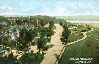
The Western Promenade is a historic promenade, an 18.1-acre (7.3 ha) public park and recreation area in the West End neighborhood of Portland, Maine. Developed between 1836 and the early 20th century, it is one Portland's oldest preserved spaces, with landscaping by the Olmsted Brothers, who included it in their master plan for the city's parks. The promenade was listed on the National Register of Historic Places in 1989.
The Lower West Side is a neighborhood in Buffalo, New York.
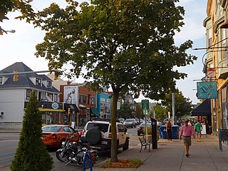
Elmwood Village is a neighborhood in Buffalo, New York.

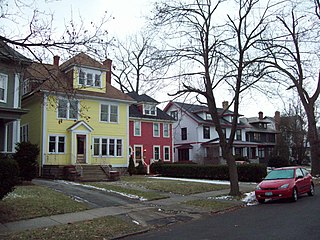
Elmwood Historic District–West is a national historic district located at Buffalo, Erie County, New York. The district encompasses 1,971 contributing buildings, 4 contributing structures, and 13 contributing objects in the Elmwood Village neighborhood of Buffalo. It is built around the Buffalo Parks and Parkways system bounded on the north by Delaware Park, Forest Lawn Cemetery, and the former Buffalo State Asylum, on the south by the Allentown Historic District, and on the east by the Elmwood Historic District–East. This predominantly residential district developed between about 1867 and 1941, and includes notable examples of Queen Anne, Shingle Style, Colonial Revival, Tudor Revival, and American Craftsman style architecture. The district contains one of the most intact collections of built resources from turn of the 20th century in the city of Buffalo and western New York State. Located in the district are six previously listed contributing resources including the Richmond Avenue Methodist-Episcopal Church and the Buffalo Tennis and Squash Club. Other notable building include the H.C. Gerber House (1908), the Fred Dullard House (1910), the William H. Scott House (1904), St. John's-Grace Episcopal Church designed by Bertram Grosvenor Goodhue (1925–26), Davidson House (1885), former Jehle Grocery Store and Residence, St. Luke's Episcopal Church, Temple Beth El, Richmond Avenue Church of Christ (now Bryant Parish Condominiums, and Pilgrim-St. Luke's United Church of Christ.
Elmwood Historic District–East is a national historic district located at Buffalo, Erie County, New York. The district encompasses 2,405 contributing buildings, 31 contributing structures, and 14 contributing objects in the Elmwood Village neighborhood of Buffalo. It is bounded on the north by Delaware Park, Forest Lawn Cemetery, and the former Buffalo State Asylum, on the south by the Allentown Historic District, and on the west by the Elmwood Historic District–West. This predominantly residential district developed between about 1867 and 1965, and includes notable examples of Queen Anne, Shingle Style, Colonial Revival, Tudor Revival, and American Craftsman style architecture. The district contains one of the most intact collections of built resources from turn of the 20th century in the city of Buffalo and western New York State. Located in the district are 17 previously listed contributing resources including the Buffalo Seminary, Garret Club, James and Fanny How House, Edgar W. Howell House, Edwin M. and Emily S. Johnston House, Col. William Kelly House, Lafayette Avenue Presbyterian Church, Parke Apartments, and the Unitarian Universalist Church of Buffalo. Other notable building include the Frank Lloyd Wright designed William R. Heath House (1904-1905), Herbert H. Hewitt House, School 56 (1910-1911), the Harlow House, A. Conger Goodyear house, Alexander Main Curtiss House, Nardin Academy campus, and Coatsworth House (1897).