
The Black Sea Lowland is a major geographic feature of the Northern Pontic region and the East European Plain. It is almost completely within Southern Ukraine covering half of its territory.
The Black Sea Lowland is a major geographic feature of the Northern Pontic region and the East European Plain. It is almost completely within Southern Ukraine covering half of its territory.
The lowland is located along the northern shores of Black Sea, stretching from west to east from the Danubian Plain, contiguous with the Wallachian Plain and forming the Lower Danubian Plain, [1] and Bugeac. Past Molochna River to the east, it transforms into a narrow Azov Littoral, Azov Lowland. To the south-east the Black Sea Lowland extends onto the Crimean peninsula where it is known as Crimean Lowland. The northern borders composed out of several uplands such as Moldavian Plateau, Podillia Upland, Dnieper Upland, Zaporizhian Ridge, Azov Upland. Azov, Crimean, and Bugeac lowlands consider to be extension of the Black Sea Lowland and its regional extremities.
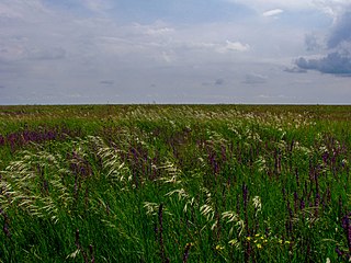
Black Sea Lowland is an accumulative, weakly divided plain which being part of the greater Eastern European Plain gradually slopes towards the Black Sea and the Sea of Azov.
Ukraine is the second-largest European country, after Russia. Its various regions have diverse geographic features ranging from highlands to lowlands, as well as climatic range and a wide variety in hydrography. Most of the country lies within the East European Plain.

The Sea of Azov is an inland shelf sea in Eastern Europe connected to the Black Sea by the narrow Strait of Kerch, and is sometimes regarded as a northern extension of the Black Sea. The sea is bounded by Russia on the east, and by Ukraine on the northwest and southwest, currently under Russian occupation. It is an important access route for Central Asia, from the Caspian Sea via the Volga–Don Canal.
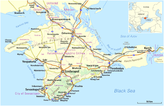
Crimea is a peninsula in Eastern Europe, on the northern coast of the Black Sea, almost entirely surrounded by the Black Sea and the smaller Sea of Azov. The Isthmus of Perekop connects the peninsula to Kherson Oblast in mainland Ukraine. To the east, the Crimean Bridge, constructed in 2018, spans the Strait of Kerch, linking the peninsula with Krasnodar Krai in Russia. The Arabat Spit, located to the northeast, is a narrow strip of land that separates the Syvash lagoons from the Sea of Azov. Across the Black Sea to the west lies Romania and to the south is Turkey. The largest city is Sevastopol. The region has a population of 2.4 million, and has been under Russian occupation since 2014.
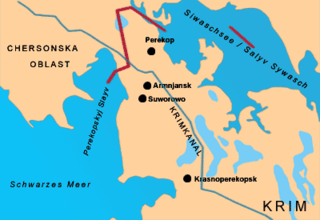
The Isthmus of Perekop, literally Isthmus of the Trench, is the narrow, 5–7 kilometres (3.1–4.3 mi) wide strip of land that connects the Crimean Peninsula to the mainland of Ukraine. The isthmus projects between the Black Sea to the west and the Syvash to the east. The isthmus takes its name of "Perekop" from the Tatar fortress of Or Qapi.
The East European Plain is a vast interior plain extending east of the North European Plain, and comprising several plateaus stretching roughly from 25 degrees longitude eastward. It includes Volhynian-Podolian Upland on its westernmost fringe, the Central Russian Upland, and, on the eastern border, encompasses the Volga Upland. The plain includes also a series of major river basins such as the Dnepr Basin, the Oka–Don Lowland, and the Volga Basin. At the southeastern point of the East European Plain are the Caucasus and Crimean mountain ranges. Together with the North European Plain, and covering the Baltic states, European Russia, Belarus, Ukraine, Moldova, southeastern Romania, and, at its southernmost point, the Danubian Plain in Northern Bulgaria, it constitutes the majority of the Great European Plain, the greatest mountain-free part of the European landscape. The plain spans approximately 4,000,000 km2 (2,000,000 sq mi) and averages about 170 m (560 ft) in elevation. The highest point of the plain, located in the Valdai Hills, is 346.9 metres (1,138.1 ft).

Europe is traditionally defined as one of seven continents. Physiographically, it is the northwestern peninsula of the larger landmass known as Eurasia ; Asia occupies the centre and east of this continuous landmass. Europe's eastern frontier is usually delineated by the Ural Mountains in Russia, which is the largest country by land area in the continent. The southeast boundary with Asia is not universally defined, but the modern definition is generally the Ural River or, less commonly, the Emba River. The boundary continues to the Caspian Sea, the crest of the Caucasus Mountains, and on to the Black Sea. The Bosporus, the Sea of Marmara, and the Dardanelles conclude the Asian boundary. The Mediterranean Sea to the south separates Europe from Africa. The western boundary is the Atlantic Ocean. Iceland is usually included in Europe because it is over twice as close to mainland Europe as mainland North America. There is ongoing debate on where the geographical centre of Europe falls.
The Pontic–Caspian Steppe, is a Steppe extending across Eastern Europe to Central Asia, is formed by the Caspian and Pontic steppes, which stretches from the northern shores of the Black Sea to the northern area around the Caspian Sea, where it ends at the Ural-Caspian narrowing, which joins it with the Kazakh Steppe in Central Asia, making it a part of the larger Eurasian Steppe. Geopolitically, the Pontic-Caspian Steppe extends from northeastern Bulgaria and southeastern Romania through Moldova and eastern Ukraine, through the Northern Caucasus of southern Russia, and into the Lower Volga region where it straddles the border of southern Russia and western Kazakhstan. Biogeographically, it is a part of the Palearctic realm, and of the temperate grasslands, savannas, and shrublands biome.
Azov Cossack Host was a Cossack host that existed on the northern shore of the Sea of Azov, between 1832 and 1862.

The Central Russian Upland is an upland area of the East European Plain and is an undulating plateau with an average elevation of 230–250 m (750–820 ft). Its highest peak is measured at 293 m (961 ft). The southeastern portion of the upland known as the Kalach Upland. The Central Upland is built of Precambrian deposits of the crystalline Voronezh Massif.

The European Plain or Great European Plain is a plain in Europe and is a major feature of one of four major topographical units of Europe - the Central and Interior Lowlands. It is the largest mountain-free landform in Europe, although a number of highlands are identified within it.

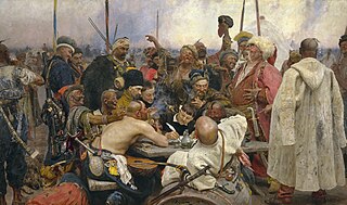
The Wild Fields is a historical term used in the Polish–Lithuanian documents of the 16th to 18th centuries to refer to the Pontic steppe in the territory of present-day Eastern and Southern Ukraine and Western Russia, north of the Black Sea and Azov Sea. It was the traditional name for the Black Sea steppes in the 16th and 17th centuries. In a narrow sense, it is the historical name for the demarcated and sparsely populated Black Sea steppes between the middle and lower reaches of the Dniester in the west, the lower reaches of the Don and the Siverskyi Donets in the east, from the left tributary of the Dnipro — Samara, and the upper reaches of the Southern Bug — Syniukha and Ingul in the north, to the Black and Azov Seas and Crimea in the south.

The North German Plain or Northern Lowland is one of the major geographical regions of Germany. It is the German part of the North European Plain. The region is bounded by the coasts of the North Sea and the Baltic Sea to the north, Germany's Central Uplands to the south, by the Netherlands to the west and Poland to the east.
The Moldavian Plateau is a geographic area of the historical region of Moldavia, spanning nowadays the east and northeast of Romania, most of Moldova, and most of the Chernivtsi Oblast of Ukraine.

This division of Germany into major natural regions takes account primarily of geomorphological, geological, hydrological, and pedological criteria in order to divide the country into large, physical units with a common geographical basis. Political boundaries play no part in this, apart from defining the national border.

The Dnieper Upland or Cisdnieper Upland is a southeastern European plain occupying the territory between the Dnieper and the Southern Bug. It lies in central Ukraine, occupying the oblasts of Zhytomyr, Kyiv, Vinnytsia, Cherkasy, Kirovohrad and Dnipropetrovsk.

The Nogais are a Turkic ethnic group who live in the North Caucasus region. Most are found in Northern Dagestan and Stavropol Krai, as well as in Karachay-Cherkessia and Astrakhan Oblast; some also live in Chechnya, Dobruja, Turkey, Kazakhstan, Uzbekistan, Ukraine and a small Nogai diaspora is found in Jordan. They speak the Nogai language and are descendants of various Mongolic and Turkic tribes who formed the Nogai Horde. There are seven main groups of Nogais: the Ak Nogai, the Karagash, the Kuban-Nogai, the Kundraw-Nogai, the Qara-Nogai, the Utars and the Yurt-Nogai.

Pryazovia or literally Cis-Azov region is usually used to refer to the geographic area of the north coast of the Sea of Azov. It is located in the southern part of the Azov-Kuban Lowland within the East European Plain, which surrounds the Sea of Azov for most of the stretch of coastline. In a more general sense it may mean the Azov Sea littoral, and conversely, to be more specific, it may also be referred to as the Northern Priazovye.

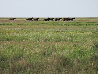
The wildlife of Ukraine consists of its diverse fauna, flora and funga. The reported fauna consists of 45,000 species when including the areas of the Black Sea and the Sea of Azov. Ukraine's protected environments consist of 33 Ramsar sites covering an area of 7,446.51 square kilometres (2,875.11 sq mi). Biosphere nature reserves and three national parks are all part of the GEF projects portfolio of conservation of biodiversity in the Danube Delta. Their vegetation pattern is mixed forest area, forest-steppe area, steppe area, Ukrainian Carpathian Mountains and Crimean Mountains. Some of the protected areas that were reserves or parks are subsumed under the biosphere reserves.
Azov Upland is a plateau or range of hills in East Ukraine within the Donetsk and Zaporizhia oblasts.

Dnieper Lowland is a major geographic feature of the Central Ukraine region and the East European Plain.
| International | |
|---|---|
| National | |
| | This article about a location in Ukraine is a stub. You can help Wikipedia by expanding it. |