The geography of Ukraine varies greatly from one region of the country to another, with the majority of the country lying within the East European Plain. Ukraine is the second-largest European country, after Russia. Its various regions have diverse geographic features ranging from highlands to lowlands, as well as climatic range and a wide variety in hydrography.

The Soviet Union incorporated an area of over 22,402,200 square kilometres (8,649,500 sq mi), covering approximately one-sixth of Earth's land surface. It was only slightly smaller in land area than the entire continent of North America and spanned most of Eurasia. Its largest and most populous republic was the Russian SFSR which covered roughly three-quarters of the surface area of the union, including the complete territory of contemporary Russia.
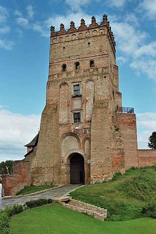
Volhynia, is a historic region in Central and Eastern Europe, between southeastern Poland, southwestern Belarus, and western Ukraine. The borders of the region are not clearly defined, but the territory that still carries the name is Volyn Oblast, in western Ukraine.

Europe is traditionally defined as one of seven continents. Physiographically, it is the northwestern peninsula of the larger landmass known as Eurasia ; Asia occupies the centre and east of this continuous landmass. Europe's eastern frontier is usually delineated by the Ural Mountains in Russia, which is the largest country by land area in the continent. The southeast boundary with Asia is not universally defined, but the modern definition is generally the Ural River or, less commonly, the Emba River. The boundary continues to the Caspian Sea, the crest of the Caucasus Mountains, and on to the Black Sea. The Bosporus, the Sea of Marmara, and the Dardanelles conclude the Asian boundary. The Mediterranean Sea to the south separates Europe from Africa. The western boundary is the Atlantic Ocean. Iceland is usually included in Europe because it is over twice as close to mainland Europe as mainland North America. There is ongoing debate on where the geographical centre of Europe falls.

The North European Plain is a geomorphological region in Europe that covers all or parts of Belgium, the Netherlands, Germany, Denmark, and Poland.
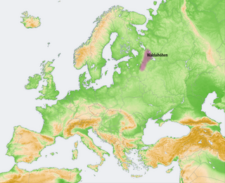
The Valdai Hills, sometimes referred to as just Valdai, are an upland region in the north-west of central European Russia running north–south, about midway between Saint Petersburg and Moscow, spanning the Leningrad, Novgorod, Tver, Pskov, and Smolensk oblasts.
The Volga Upland, also known as the Volga Uplands, Volga Hills, or Volga Plateau, is a vast region of the East European Plain in the European part of Russia that lies west of the Volga River and east of the Central Russian Upland.

The Central Russian Upland is an upland area of the East European Plain and is an undulating plateau with an average elevation of 230–250 m (750–820 ft). Its highest peak is measured at 293 m (961 ft). The southeastern portion of the upland known as the Kalach Upland. The Central Upland is built of Precambrian deposits of the crystalline Voronezh Massif.
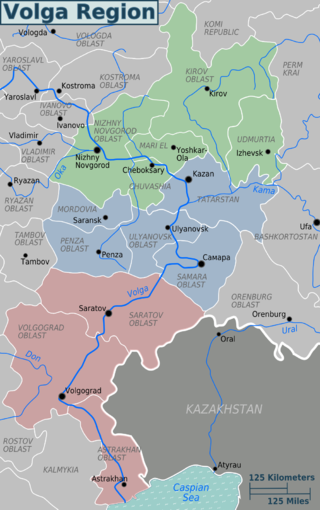
The Volga region is a historical region in Russia that encompasses the drainage basin of the Volga River, the longest river in Europe, in central and southern European Russia.

The North German Plain or Northern Lowland is one of the major geographical regions of Germany. It is the German part of the North European Plain. The region is bounded by the coasts of the North Sea and the Baltic Sea to the north, Germany's Central Uplands to the south, by the Netherlands to the west and Poland to the east.
The Moldavian Plateau is a geographic area of the historical region of Moldavia, spanning nowadays the east and northeast of Romania, most of Moldova, and most of the Chernivtsi Oblast of Ukraine.

The Dnieper Upland or Cisdnieper Upland is a southeastern European plain occupying the territory between the Dnieper and the Southern Bug. It lies in central Ukraine, occupying the oblasts of Zhytomyr, Kyiv, Vinnytsia, Cherkasy, Kirovohrad and Dnipropetrovsk.

Volhynian-Podolian Upland is a system of uplands in West Ukraine and Right-bank Ukraine.
The Black Sea Lowland is a major geographic feature of the Northern Pontic region and the East European Plain. It is almost completely within Southern Ukraine covering half of its territory.

Eastern Carpathian Foothills as a geographical term designates transitional region in the western parts of Ukraine and northeastern parts of Romania, between Eastern Carpathian Mountains to the southwest and number of plain regions to the east and north. Its average elevation is around 300–500 m (980–1,640 ft) above sea level. The region stretches across Lviv, Ivano-Frankivsk and Chernivtsi Oblasts and Suceava County.

Dnieper Lowland is a major geographic feature of the Central Ukraine region and the East European Plain.
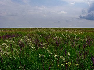
The East European forest steppe ecoregion is a patchwork of broadleaf forest stands and grasslands (steppe) that stretches 2,100 km across eastern Europe from the Ural Mountains in Ural, through Povolzhye, Central Russia to the middle of Ukraine.There are isolated areas of similar character off the western end in eastern Romania, Moldova, and Bulgaria.

The Great Russian Regions are eight geomorphological areas in the Russian Federation displaying characteristic forms of relief. Seven of them are east of the Urals.


