Blackstone, Providence, Rhode Island

Last updated
Blackstone, Providence, Rhode Island

Blackstone is a predominantly residential neighborhood in Providence, Rhode Island. It is in the northeast corner of the city and is bounded to the south and west by Lloyd Avenue and Hope Street respectively. It is one of six neighborhoods comprising the East Side of Providence.

Contents

View of Blackstone Boulevard Park trees and path in winter, Providence, Rhode Island. Blackstone Boulevard view in winter.png
View of Blackstone Boulevard Park trees and path in winter, Providence, Rhode Island.

History

Swan Point Cemetery is the final resting place of several Rhode Island governors, including Herbert W. Ladd RI Governor Herbert W Ladd Grave.jpg
Swan Point Cemetery is the final resting place of several Rhode Island governors, including Herbert W. Ladd

Blackstone is one of the last parts of Providence to be developed, as the remoteness of its location and marshy land had precluded significant development before the late 19th century. It wasn't until construction of Blackstone Boulevard in 1894 as a means of reaching Swan Point Cemetery that the area saw extensive residential development.

The area was largely marshland, and the earliest road was Cat Swamp Lane followed the high ground. Several farms were located in the area during the 1700s, and a few farmhouses from that era remain. [1] In the late 1700s, several burial grounds were established in the remote western part of the city. Several of these by 1847 and 1858 became consolidated into present-day Swan Point Cemetery. [2]

Construction of Blackstone Boulevard

By the 1870s the cemetery was accessible by means of a public omnibus which journeyed by means of a winding zigzag road which ran along present-day North Main Street, Olney Street, Morris Avenue, Sessions Street, Cole Avenue, and Rochambeau. [2] In 1886 the directors of Swan Point Cemetery hired landscape architect Horace Cleveland of Chicago to plan a road to improve access to the cemetery from the town of Providence. This road opened in 1894 as Blackstone Boulevard. [2]

Blackstone Boulevard became a catalyst for development in the neighborhood, spurring construction of single family homes which were "architecturally distinctive" from the rest of the city. [1] Between 1890 and 1923, property values along the Boulevard tripled, as the neighborhood became one of the most desirable and fashionable in the city. [1] In the early 1900s, the Boulevard was redesigned to create the Blackstone Boulevard Park. [3] [4]

Community Church of Providence, formerly Central Baptist Church, at Wayland and Lloyd Ave. Community Church of Providence.jpg
Community Church of Providence, formerly Central Baptist Church, at Wayland and Lloyd Ave.

The 20th century saw institutional development in the form of Central Baptist Church, Temple Emanuel, and St. Sebastian's Roman Catholic Church.

Description

The Blackstone neighborhood comprises the northeast corner of the East Side of Providence, between the eastern ridge of the Moshassuck River Valley and the western bank of the Seekonk River. [1] Blackstone is primarily residential, and made up of mainly of single-family dwellings. It is one of the city's most affluent neighborhoods. [1]

Houses of Worship

Temple Emmanuel at Morris Ave and Sessions Street Temple Emmanuel, Providence Rhode Island.jpg
Temple Emmanuel at Morris Ave and Sessions Street

Notable religious institutions in the area include Temple Emanu-El, St. Sebastian's Roman Catholic Church and the Community Church of Providence (formerly Central Baptist).

The Community Church began as an offshoot of the First Baptist Church in America. [6] The congregation originally was known as the Second Baptist Church, then Pine Street Baptist, and in 1917 opened at Lloyd and Wayland Street as Central Baptist. [6] In 2003, the church became known as Community Church of Providence.

Between 1917 and 2018 the building featured a large Tiffany stained glass memorial to Frederick W. Hartwell created by Agnes F. Northrop [7] entitled "Light in Heaven and Earth". [6] The complex work was considered "one of the largest and finest landscape windows ever produced by Tiffany Studios", but largely was overlooked in the community. [6] In 2018, the church sold the window to the Art Institute of Chicago where it is undergoing conservation and preparation to be displayed prominently in September 2020 as the Hartwell Memorial Window. [6]

Brown University

Brown Stadium Brown University football stadium.jpg
Brown Stadium

Brown University built several facilities in the neighborhood. Ladd Observatory was built in 1891 on the edge of the neighborhood at Hope Street and Doyle Avenue. In the 1920s Brown built several athletic facilities along Elmgrove Avenue, including Brown Stadium (1925), Aldrich Field (1925—1961), [8] and Marvel Gymnasium (1927—1989). [9] Aldrich field was sold in 1961 and developed as a residential neighborhood, with streets named for Brown presidents Maxcy, Faunce, Barbour, and Wriston. [8] Marvel Gym was closed in 1989 and demolished. [9]

Hospitals

Butler Hospital, 1886 engraving Butler Hospital for the Insane.jpg
Butler Hospital, 1886 engraving

Butler Hospital, located off Blackstone Boulevard, is Rhode Island's only private mental health hospital. Founded in 1844, the hospital offers psychiatric and substance-abuse treatment programs. [10] The hospital was built in 1847 on the Richard Browne Farm at the end of Rochambeau Avenue. [1] The building is a huge Gothic structure surrounded by landscaping, built according to the philosophy of the time to remove patients from the stresses of urban life to a rural setting. [1]

Parks

Demographics

According to the Providence Plan,a local nonprofit aimed at improving city life, 92.5% of residents are white, well above the citywide average of 54.5%. [13]

Blackstone is one of the most affluent neighborhoods in the city with a median family income nearly four times that of the city and housing values more than doubling in recent years. The median household income is $87,727, and the median family income is $117,522. Only 1.1% of families live below the poverty line. [13]

The neighborhood is home to a significant Jewish population. The Jewish Community Center of Rhode Island was established on Elmgrove Avenue in 1971; later this merged with other communal organizations and became known as the Jewish Alliance of Rhode Island. [14] The area is also home to the Providence Hebrew Day School on Elmgrove Avenue and Temple Emmanuel on Morris Avenue.

Government

Ward Two encompasses Blackstone, all of College Hill and Wayland north of Angell Street, and parts of Mount Hope. [15] As of the 2018 elections, Helen Anthony, a Democrat, represents the ward in the City Council. [16]

Related Research Articles

<span class="mw-page-title-main">Route 15 (Rhode Island–Massachusetts)</span> Highway in Rhode Island and Massachusetts

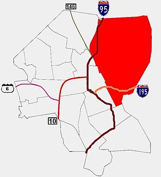
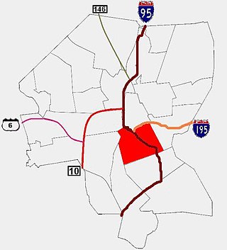
Route 15 is a state highway in the U.S. states of Rhode Island and Massachusetts. The highway runs 8.3 miles (13.4 km) from U.S. Route 44 in North Providence, Rhode Island east through Pawtucket to the Massachusetts state line, where the highway continues for 0.23 miles (0.37 km) to Route 152 in Seekonk.

<span class="mw-page-title-main">Solomon Drowne</span> American physician

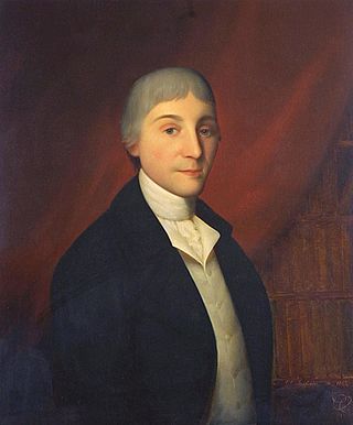
Dr. Solomon Drowne was a prominent American physician, academic and surgeon during the American Revolution and in the history of the fledgling United States.

<span class="mw-page-title-main">Thomas Alexander Tefft</span> American architect

Thomas Alexander Tefft was an American architect, from Providence, Rhode Island. Tefft, one of the nation's first professionally trained architects, is considered a master of Rundbogenstil and a leading American proponent of its use. Prior to his untimely death, Tefft "offered the most advanced designs of [his] day in America"

<span class="mw-page-title-main">Seekonk River</span> River in Rhode Island, United States

The Seekonk River is a tidal extension of the Providence River in the U.S. state of Rhode Island. It flows approximately 8 km (5 mi). The name may be derived from an Algonquian word for skunk, or for black goose. The river is home to the Brown University men's rowing team, India Point Park, Blackstone Park, Crook Point Bascule Bridge, Narragansett Boat Club, Swan Point Cemetery, and the Bucklin Point waste-water treatment facility. The River is listed by RIDEM as an impaired waterway.

<span class="mw-page-title-main">Ten Mile River (Seekonk River tributary)</span> River in Massachusetts and Rhode Island, United States

The Ten Mile River is a river within the U.S. states of Massachusetts and Rhode Island. It flows approximately 22 miles (35 km) and drains a watershed of 54 square miles (140 km2).

<span class="mw-page-title-main">Fox Point, Providence, Rhode Island</span> Neighborhood of Providence in Rhode Island, United States

Fox Point is a neighborhood in the East Side of Providence, Rhode Island. It is bounded by the Providence and Seekonk rivers, Interstate 195 and the College Hill and Wayland neighborhoods. Fox Point is the southernmost neighborhood in the East Side area of Providence.

<span class="mw-page-title-main">East Side, Providence, Rhode Island</span> Collection of neighborhoods

The East Side is a collection of neighborhoods in the eastern part of the city of Providence, Rhode Island. It officially comprises the neighborhoods of Blackstone, Hope, Mount Hope, College Hill, Wayland, and Fox Point.

<span class="mw-page-title-main">Elmhurst, Providence, Rhode Island</span>

Elmhurst is a primarily residential neighborhood in the northwest quadrant of Providence, Rhode Island. Douglas Avenue and Admiral Street bound Elmhurst to the northeast, Academy Avenue and Smith Street bound it to the west, while Chalkstone Avenue marks the southern border.

<span class="mw-page-title-main">Upper South Providence, Providence, Rhode Island</span>

Upper South Providence is an official neighborhood in the South Side in the city of Providence, Rhode Island. It is bound to the north by Interstate 95, the east by the Providence River, to the south by Public Street, and the west by Broad Street. Often associated with Lower South Providence directly to its south, Upper South Providence is a distinct neighborhood.

<span class="mw-page-title-main">College Hill Historic District (Providence, Rhode Island)</span> Historic district in Rhode Island, United States

The College Hill Historic District is located in the College Hill neighborhood of Providence, Rhode Island. It was designated a National Historic Landmark District on December 30, 1970. The College Hill local historic district, established in 1960, partially overlaps the national landmark district. Properties within the local historic district are regulated by the city's historic district zoning ordinance, and cannot be altered without approval from the Providence Historic District Commission.

The Blackstone Boulevard Realty Plat Historic District is a historic district roughly bounded by Blackstone Blvd., Rochambeau Ave., Holly St. and Elmgrove Ave. in Providence, Rhode Island.

<span class="mw-page-title-main">Blackstone Park Historic District</span> Historic district in Rhode Island, United States

Blackstone Park Historic District is roughly bounded by the Seekonk River, Laurell Avenue, Blackstone Boulevard, and South Angell Street in Providence, Rhode Island within the Blackstone region of the East Side.

<span class="mw-page-title-main">Elmgrove Gardens Historic District</span> Historic district in Rhode Island, United States

The Elmgrove Gardens Historic District is a residential historic district in northeastern Providence, Rhode Island, United States. It is bounded on the north by Rochambeau Street, on the south by Woodbury Street, on the east by Cole Street, and on the west by Morris Avenue. This area was developed most heavily between 1908 and 1948, and is a well-preserved example of an early automotive suburban residential area. Most of the houses in the district are either 1-1/2 or 2-1/2 stories in height, and are built in an architecturally diverse variety of styles. The district also includes to 18th-century farmhouses, reminders of the area's agrarian past.

Domenic Thomas Russillo, AIA (1902-1980), was a minor American architect who practiced in mid-20th-century Rhode Island and Massachusetts.

<span class="mw-page-title-main">Blackstone Boulevard–Cole Avenue–Grotto Avenue Historic District</span> Historic district in Rhode Island, United States

The Blackstone Boulevard–Cole Avenue–Grotto Avenue Historic District is a predominantly residential historic district roughly bounded by Blackstone Boulevard, Cole Avenue, Grotto Avenue, President and Rochambeau Avenues on the east side of Providence, Rhode Island. It encompasses one of the last areas of the city be developed residentially. Covering about 100 acres (40 ha), most of its building stock was built between about 1889 and the 1940s, with a notable building spurt taking place in the 1920s. The architecture in the area is heterogeneous, with Colonial and Georgian Revival styles predominating. The area was developed after the city built Blackstone Boulevard with the intention of developing the area into a streetcar suburb.

<span class="mw-page-title-main">Alfred Stone (architect)</span> American architect (1834 - 1908)

Alfred Stone was an American Architect. He was a founding partner of the Providence, Rhode Island, firm of Stone, Carpenter & Willson. Mr. Stone was best known for designing many prominent Rhode Island buildings, including the Providence Public Library, Union Station, buildings at Brown University and the University of Rhode Island, and many private homes.

John F. O'Malley was an American architect from Rhode Island.

<span class="mw-page-title-main">Clarke & Howe</span> American architectural firm

Clarke & Howe was an American architectural firm from Providence, Rhode Island that was active from 1893 to 1928.

<span class="mw-page-title-main">Blackstone Park Conservation District</span> Public park in Providence, Rhode Island

The Blackstone Park Conservation District is a public, 45-acre woodland conservation area on the East Side of Providence, Rhode Island. It is run by the non-profit Blackstone Parks Conservancy in partnership with the Providence Parks Department. The park is situated on the west bank of the tidal Seekonk River, within the watershed and wildlife corridor of the Blackstone River Valley. Unlike many city parks, it is actively managed for the purpose of providing habitats for wildlife and supporting a healthy ecosystem for native flora and fauna.

<span class="mw-page-title-main">Blackstone Boulevard Park</span> Public park in Providence, Rhode Island

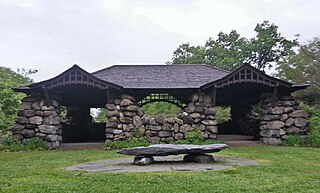
Blackstone Boulevard Park is a public park and footpath that runs down the center of Blackstone Boulevard on the East Side of Providence, Rhode Island. It is located in the Blackstone neighborhood, an affluent and primarily residential part of Providence. The park is well-used by joggers and dog walkers from the East Side of Providence and surrounding areas. Along with the Blackstone Park Conservation District, it is run in partnership between the non-profit Blackstone Parks Conservancy and the Providence Parks Department. The Conservancy actively maintains the condition of the park and path, as well as planting and caring for the trees and other flora along the path. Blackstone Boulevard is also a part of the National Register of Historic Places, at the boundary of the Blackstone Park Historic District and Blackstone Boulevard Realty Plat Historic District.

References

  1. 1 2 3 4 5 6 7 Deller, Thomas E. (2009). Providence Tomorrow: Mt. Hope, Hope, and Blackstone Neighborhood Plan (PDF). Providence Department of Planning and Development. pp. 9–10. Retrieved 23 February 2020.
  2. 1 2 3 "Swan Point Cemetery Founding & Early Years". Swan Point Cemetery. Providence, Rhode Island. Archived from the original on 13 April 2019. Retrieved 13 April 2019.
  3. The Master List of Design Projects of the Olmsted Firm, 1857-1979. National Association for Olmsted Parks. 2008.
  4. Charter and Special Laws Governing the City of Providence, Chapter 875, Sect 1. Providence Printing Company. 1916. Retrieved August 28, 2021.
  5. "Our Story & Home". Community Church of Providence. Retrieved 13 July 2018. it also changed its name twice: first to Pine Street Baptist Church, then to Central Baptist
  6. 1 2 3 4 5 Naylor, Donita (21 February 2020). "Tiffany church window, unnoticed in Providence, will be a star attraction in Chicago art museum". The Providence Journal. Archived from the original on 23 February 2020. Retrieved 23 February 2020.
  7. McGreevy, Nora, Stunning Tiffany Stained Glass Debuts After 100 Years of Obscurity , Smithsonian Magazine, May 28, 2021
  8. 1 2 Mitchell, Martha (1993). Encyclopedia Brunoniana. Brown University Library. Retrieved 13 April 2019.
  9. 1 2 Mitchell, Martha (1993). Encyclopedia Brunoniana. Brown University Library. Retrieved 13 April 2019.
  10. Butler Hospital, Providence Rhode Island : About Butler Hospital
  11. 1 2 Citywide Green
  12. Google Maps
  13. 1 2 Blackstone Archived 2007-09-28 at the Wayback Machine
  14. "History". Jewish Alliance of Greater Rhode Island. Retrieved 13 April 2019.
  15. ward2.jpg Archived 2006-11-15 at archive.today
  16. "Providence City Council". Archived from the original on 2019-02-13. Retrieved 2019-02-13.

Coordinates: 41°50′N71°23′W / 41.84°N 71.39°W / 41.84; -71.39