East Side, Providence, Rhode Island

Last updated
Providence neighborhoods with the East Side in red Provneigheastside.JPG
Providence neighborhoods with the East Side in red

The East Side is a collection of neighborhoods in the eastern part of the city of Providence, Rhode Island. It officially comprises the neighborhoods of Blackstone, Hope (commonly known as Summit), Mount Hope, College Hill, Wayland, and Fox Point. [1] [2] [3]

Contents

View of skyscrapers in Downtown Providence from College Hill George Street, on the East Side of Providence RI.jpg
View of skyscrapers in Downtown Providence from College Hill

The area is separated from East Providence, Rhode Island, to the east by the Seekonk River. To the west it is separated from the rest of Providence by the Providence River and Interstate 95. To the north, it borders Pawtucket, Rhode Island. To the south, it abuts Narragansett Bay, which is formed by the confluence of the Seekonk and Providence Rivers.

Roger Williams founded Providence along College Hill. This area thus includes some of the oldest sections of the city. The spot where Williams landed after crossing the Seekonk River is marked by a small park in Fox Point.

Universities and schools

The East Side contains most of Brown University's academic and athletic facilities. These include the Main Green, the Rockefeller Library, the Erickson Athletic Complex, the Pembroke Campus, and the Watson Institute for International and Public Affairs. Many of the Rhode Island School of Design's buildings are along the slope of College Hill. The RISD Museum is located on Benefit Street.

Private schools include the Moses Brown School, the Wheeler School, Lincoln School, School One, Providence Hebrew Day School, and the French-American School.

Hope High School is located at the corner of Hope and Olney Streets. It is one of Providence's public high schools. [4]

Restaurants and shopping

Original 1650 settlement plots on the East Side. Wickenden Street map.jpg
Original 1650 settlement plots on the East Side.

Numerous cafes, restaurants, and shops are located along Thayer Street, adjoining Brown University at Veteran's Gate, and along Wickenden Street, South Water Street. Both streets are home to numerous small and independent shops, though Thayer Street has a few chain stores. Brown University's bookstore is located on Thayer. [5] A notable Thayer Street landmark is the Avon Cinema which dates back to the early twentieth century. [6]

Wayland Square is another shopping area, located at the intersection of Wayland Ave. and Angell St.

Parks

Prospect Terrace Park, College Hill Prospect Terrace Park after snowfall, Providence, Rhode Island.jpg
Prospect Terrace Park, College Hill
India Point Park, Fox Point India Point Park (9340627306).jpg
India Point Park, Fox Point
Blackstone Park Blackstone park.jpg
Blackstone Park

The East Side contains numerous parks and green spaces. India Point Park, the largest of these, is located along the northernmost shore of Narragansett Bay. It is the only large expanse of Bay-side shoreline in Providence reserved for public use.

Interstate 195 separates the park from the rest of Fox Point. The relocation and reconstruction of Interstate 195 included a new, landscaped pedestrian bridge connecting Fox Point to India Point Park.

Other parks include:

Demographics

Mostly residential, [13] the East Side is the most affluent part [14] of the city with higher property values, lower unemployment, and higher income levels than the city as a whole. [15] Approximately 20% of the city's 190,934 people live on the East Side. [16] Mount Hope and the area along Elmgrove Avenue have historically had a large community of Russian Jews. [17]

Government

Ladder Co. 8 and Engine Co. 9 on Brook Street Brook Street Fire Station L8 and E9, Providence RI.jpg
Ladder Co. 8 and Engine Co. 9 on Brook Street

Three of the fifteen Providence City Council wards are located on the East Side. Ward One includes all of Fox Point and parts of College Hill and Wayland south of Angell St. [18] Ward Two encompasses the remainder of College Hill and Wayland, most of Blackstone, and parts of Mount Hope. [19] Ward Three includes Hope (Summit) and most of Mount Hope. [20]

Major public buildings include the Rhode Island Supreme Court on Benefit Street and the RI Office of the Attorney General on South Main Street. [21]

Hospitals

Miriam Hospital, a private, non-profit hospital, is located along Summit Avenue in the Hope (Summit) area. Local Jewish organizations founded the hospital in 1926. [22]

Butler Hospital, located off Blackstone Boulevard, is Rhode Island's only private mental health hospital. Founded in 1844, the hospital offers psychiatric and substance-abuse treatment programs. [23]

Landmarks

The East Side contains the oldest section of the city. The Providence Preservation Society [24] and the Rhode Island Historical Society have preserved numerous historic buildings, especially in the College Hill area. Historic landmarks include:

John Brown House (1786) is one of many 18th and 19th century structures on the East Side. John Brown House Providence RI 2012.jpg
John Brown House (1786) is one of many 18th and 19th century structures on the East Side.

Related Research Articles

<span class="mw-page-title-main">Thayer Street</span>

Thayer Street in Providence, Rhode Island is a popular destination for students of the area's nearby schools of Brown University, Moses Brown School, Hope High School, Wheeler School, Rhode Island School of Design, Providence College, Johnson & Wales University, and Rhode Island College.

<span class="mw-page-title-main">East Side Railroad Tunnel</span> Former railroad tunnel in Rhode Island

The East Side Railroad Tunnel is a former railroad tunnel that runs underneath the East Side of Providence, Rhode Island. The tunnel runs 5,080 feet (1,550 m), under College Hill, from Gano Street to just west of Benefit Street. It was opened on November 16, 1908, at a cost of $2 million. All rail service ceased through the tunnel in 1976 and has been abandoned since.

<span class="mw-page-title-main">Seekonk River</span> River in Rhode Island, United States

The Seekonk River is a tidal extension of the Providence River in the U.S. state of Rhode Island. It flows approximately 8 km (5 mi). The name may be derived from an Algonquian word for skunk or for black goose. The river is home to the Brown University men's rowing team, India Point Park, Blackstone Park Conservation District, Crook Point Bascule Bridge, Narragansett Boat Club, Swan Point Cemetery, and the Bucklin Point waste-water treatment facility. The River is listed by the Rhode Island Department of Environmental Management as an impaired waterway.

<span class="mw-page-title-main">Blackstone, Providence, Rhode Island</span>

Blackstone is a predominantly residential neighborhood in Providence, Rhode Island. It is in the northeast corner of the city and is bounded to the south and west by Lloyd Avenue and Hope Street respectively. It is one of six neighborhoods comprising the East Side of Providence.

<span class="mw-page-title-main">College Hill, Providence, Rhode Island</span> Neighborhood of Providence in Rhode Island, United States

College Hill is a historic neighborhood of Providence, Rhode Island, and one of six neighborhoods comprising the city's East Side. It is roughly bounded by South and North Main Street to the west, Power Street to the south, Governor Street and Arlington Avenue to the east and Olney Street to the north. The neighborhood's primary commercial area extends along Thayer Street, a strip frequented by students in the Providence area.

<span class="mw-page-title-main">Fox Point, Providence, Rhode Island</span> Neighborhood of Providence in Rhode Island, United States

Fox Point is a neighborhood in the East Side of Providence, Rhode Island. It is bounded by the Providence and Seekonk rivers, Interstate 195 and the College Hill and Wayland neighborhoods. Fox Point is the southernmost neighborhood in the East Side area of Providence.

<span class="mw-page-title-main">India Point Park</span> Park in Providence, Rhode Island

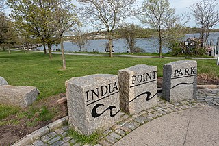
India Point Park is a park in the Fox Point neighborhood of Providence, Rhode Island at the confluence of the Seekonk River and Providence River. The park takes its name from the maritime activity connecting Providence with the East and West Indies. The East Bay Bike Path begins at the eastern end of the park, and crosses over the Washington Bridge before heading to Watchemoket Square in East Providence and continuing on to the Bristol waterfront north of the Mount Hope Bridge. The park is also a part of the Washington–Rochambeau Revolutionary Route.

<span class="mw-page-title-main">Elmhurst, Providence, Rhode Island</span>

Elmhurst is a primarily residential neighborhood in the northwest quadrant of Providence, Rhode Island. Douglas Avenue and Admiral Street bound Elmhurst to the northeast, Academy Avenue and Smith Street bound it to the west, while Chalkstone Avenue marks the southern border.

<span class="mw-page-title-main">Blackstone River Greenway</span> Partially completed paved rail trail from Worcester, MA, US to Providence, RI, US

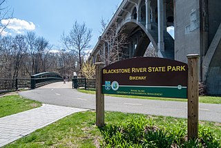
The Blackstone River Greenway is a partially completed 48-mile (77 km) paved rail trail defining the course of the East Coast Greenway through the Blackstone Valley from Worcester, Massachusetts to Providence, Rhode Island in the United States.

<span class="mw-page-title-main">Neighborhoods in Providence, Rhode Island</span>

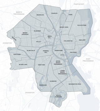
The city of Providence, Rhode Island has 25 official neighborhoods.

<span class="mw-page-title-main">Upper South Providence, Providence, Rhode Island</span>

Upper South Providence is an official neighborhood in the South Side in the city of Providence, Rhode Island. It is bound to the north by Interstate 95, the east by the Providence River, to the south by Public Street, and the west by Broad Street. Often associated with Lower South Providence directly to its south, Upper South Providence is a distinct neighborhood.

<span class="mw-page-title-main">Wickenden Street</span>

Wickenden Street in Fox Point, Providence, Rhode Island is a popular destination for students of the area's colleges and schools. The street is surrounded by schools and universities on the East Side of Providence's College Hill, including Brown University, RISD, Moses Brown School, & The Wheeler School.

<span class="mw-page-title-main">College Hill Historic District (Providence, Rhode Island)</span> Historic district in Rhode Island, United States

The College Hill Historic District is located in the College Hill neighborhood of Providence, Rhode Island. It was designated a National Historic Landmark District on December 30, 1970. The College Hill local historic district, established in 1960, partially overlaps the national landmark district. Properties within the local historic district are regulated by the city's historic district zoning ordinance, and cannot be altered without approval from the Providence Historic District Commission.

<span class="mw-page-title-main">Providence, Rhode Island</span> Capital city of Rhode Island, United States

Providence is the capital and most populous city of the U.S. state of Rhode Island. The county seat of Providence County, it is one of the oldest cities in New England, founded in 1636 by Roger Williams, a Reformed Baptist theologian and religious exile from the Massachusetts Bay Colony. He named the area in honor of "God's merciful Providence" which he believed was responsible for revealing such a haven for him and his followers. The city developed as a busy port, as it is situated at the mouth of the Providence River at the head of Narragansett Bay.

Hope Street is a major two lane bidirectional street running about three miles north to south on the East Side of Providence, Rhode Island. The street serves as a main artery serving most of the East Side district and connects the East Side to Pawtucket at the north, where it continues as East Avenue.

<span class="mw-page-title-main">Alfred Stone (architect)</span> American architect (1834 - 1908)

Alfred Stone was an American Architect. He was a founding partner of the Providence, Rhode Island, firm of Stone, Carpenter & Willson. Mr. Stone was best known for designing many prominent Rhode Island buildings, including the Providence Public Library, Union Station, buildings at Brown University and the University of Rhode Island, and many private homes.

<span class="mw-page-title-main">Wayland Square</span> Classic New England neighborhood

Wayland Square is a historic area on the East Side of Providence, Rhode Island near Brown University and the Rhode Island School of Design.

<span class="mw-page-title-main">Martin & Hall</span>

Martin & Hall was the architectural partnership of Frank W. Martin and George F. Hall (1866–1928). It was based in Providence, Rhode Island.

<span class="mw-page-title-main">Jackson, Robertson & Adams</span> American architectural firm based in Rhode Island, USA

Jackson, Robertson & Adams was an architectural firm out of Providence, Rhode Island. Established in 1912, it was originally made up of architects F. Ellis Jackson (1879–1950), Wayland T. Robertson (1873–1935), and J. Howard Adams (1876–1924).

<span class="mw-page-title-main">Angell Street</span>

Angell Street is a major one-way thoroughfare on the East Side of Providence, Rhode Island. It was named for Thomas Angell, an early settler in Providence.

References

  1. Providence Neighborhood Profiles Archived 2007-09-28 at the Wayback Machine
  2. "Archived copy". Archived from the original on 2007-09-28. Retrieved 2007-08-25.{{cite web}}: CS1 maint: archived copy as title (link)
  3. "Archived copy". Archived from the original on 2007-09-28. Retrieved 2007-08-25.{{cite web}}: CS1 maint: archived copy as title (link)
  4. Hope High School Arts Community Archived 2007-04-13 at the Wayback Machine
  5. Brown University Bookstore
  6. Avon Cinema
  7. 1 2 "Citywide Green". Archived from the original on 2007-09-28. Retrieved 2007-04-15.
  8. "Institute at Brown for Environment and Society | Brown University".
  9. "Daytripper's Guide: Providence". Archived from the original on 2007-05-03. Retrieved 2007-04-15.
  10. "Citywide Green". Archived from the original on 2007-09-28. Retrieved 2007-04-15.
  11. 1 2 "Providence Monthly Magazine". Archived from the original on 2007-06-25. Retrieved 2007-07-19.
  12. Google Maps
  13. "Freedom: From dream to reality, facing a tough path".
  14. Note: affluence was assumed to correlate with high property values, low unemployment, and high income.
  15. "Providence RI Relocation Guide - Learn all about the East Side of Providence, RI, home of Brown University". Archived from the original on 2007-10-29. Retrieved 2007-12-25.
  16. "Providence Neighborhoods: Mount Hope". Providenceri.com. Retrieved 2007-09-22.
  17. ward1.jpg
  18. ward2.jpg Archived November 15, 2006, at archive.today
  19. ward3.jpg
  20. "RI Supreme Court - FAQ's". Archived from the original on 2007-09-21. Retrieved 2007-07-15.
  21. "The Miriam Hospital". Archived from the original on 2007-04-06. Retrieved 2007-04-16.
  22. "Butler Hospital, Providence Rhode Island : About Butler Hospital". Archived from the original on 2007-04-06. Retrieved 2007-04-16.
  23. Providence Preservation Society
  24. Benefit Street, an enduring elegance | Providence | Rhode Island news | projo.com | The Providence Journal
  25. "History". Central Congregational Church. 23 September 2006.
  26. First Baptist Church in America
  27. Welcome to College Hill, the historic heart of Providence
  28. Rhode Island State Police: History Archived 2007-08-04 at the Wayback Machine
  29. Bilow, Michael (July 27, 2013). "We are Providence: The H.P. Lovecraft Community". Motif . Providence, Rhode Island . Retrieved 2013-08-04.

41°50′31″N71°23′49″W / 41.842°N 71.397°W / 41.842; -71.397