Bloomingburg | |
---|---|
Coordinates: 41°33′N74°26′W / 41.550°N 74.433°W | |
Country | United States |
State | New York |
County | Sullivan |
Founded | 1833 |
Area | |
• Total | 0.69 sq mi (1.78 km2) |
• Land | 0.69 sq mi (1.78 km2) |
• Water | 0.00 sq mi (0.00 km2) |
Elevation | 515 ft (157 m) |
Population (2020) | |
• Total | 1,032 |
• Density | 1,500.00/sq mi (578.97/km2) |
Time zone | UTC−5 (Eastern (EST)) |
• Summer (DST) | UTC−4 (EDT) |
ZIP Code | 12721 |
Area code | 845 |
FIPS code | 36-06959 |
GNIS feature ID | 0975768 |
Website | bloomingburg |
Bloomingburg, previously Bloomingburgh, is a village in the Sullivan County town of Mamakating, New York, United States. The population was 1,032 at the 2020 census.
Bloomingburg's accepted incorporation date is 1833. [2] It was the first county seat of Sullivan County, being located in the original county town of Mamakating. It prospered, first, as a center of commerce along the Newburgh–Cochecton Turnpike, then as a railway town serving vacationers in the mountains. Many guesthouses in the village were not rebuilt after the devastating fire of February 1922, and the village has been primarily an agricultural center ever since.
The Bloomingburg Reformed Protestant Dutch Church was listed on the National Register of Historic Places in 1980. [3]
Bloomingburg is located at 41°33′22″N74°26′28″W / 41.55611°N 74.44111°W (41.556159, −74.441060). [4] The village's eastern boundary is the Shawangunk Kill, Dutch for "Shawangunk River", also the Orange County line at that point, with its western boundary a short distance up the Shawangunk Ridge. It is the only population center in Sullivan County entirely within the Hudson River watershed.
The northern and southern boundaries roughly parallel Main Street, also County Route 171, the former route of NY 17, which now bypasses the village to the north as an expressway. It is served by two exits on Route 17, one for Burlingham Road and the other, just over the county line, for NY 17K.
According to the United States Census Bureau, the village has a total area of 0.3 square miles (0.78 km2), all land.
Census | Pop. | Note | %± |
---|---|---|---|
1930 | 215 | — | |
1940 | 197 | −8.4% | |
1950 | 263 | 33.5% | |
1960 | 303 | 15.2% | |
1970 | 323 | 6.6% | |
1980 | 338 | 4.6% | |
1990 | 316 | −6.5% | |
2000 | 353 | 11.7% | |
2010 | 420 | 19.0% | |
2020 | 1,032 | 145.7% | |
U.S. Decennial Census [5] |
As of the 2010 census Bloomingburg had a population of 420. 77.9% of the population was non-Hispanic whites, 4.5% non-Hispanic African American, 0.5% Native American, 1.0% Asian, 5.7% reporting two or more races and 13.3% Hispanic or Latino. [6]
As of the census [7] of 2000, there were 353 people, 146 households, and 94 families residing in the village. The population density was 1,113.7 inhabitants per square mile (430.0/km2). There were 181 housing units at an average density of 571.0 per square mile (220.5/km2). The racial makeup of the village was 92.92% white, 2.83% African American, 1.98% Asian, 0.57% from other races, and 1.70% from two or more races. Hispanic or Latino of any race were 7.93% of the population.
There were 146 households, out of which 35.6% had children under the age of 18 living with them, 50.0% were married couples living together, 11.6% had a female householder with no husband present, and 35.6% were non-families. 29.5% of all households were made up of individuals, and 10.3% had someone living alone who was 65 years of age or older. The average household size was 2.42 and the average family size was 3.04.
In the village, the population was spread out, with 27.8% under the age of 18, 9.3% from 18 to 24, 34.8% from 25 to 44, 16.1% from 45 to 64, and 11.9% who were 65 years of age or older. The median age was 32 years. For every 100 females, there were 90.8 males. For every 100 females age 18 and over, there were 90.3 males.
The median income for a household in the village was $38,571, and the median income for a family was $41,111. Males had a median income of $35,938 versus $21,750 for females. The per capita income for the village was $21,441. About 17.0% of families and 11.1% of the population were below the poverty line, including 17.7% of those under age 18 and 8.7% of those age 65 or over.
Sun River Terrace is a village in Kankakee County, Illinois, United States. The population was 455 at the 2020 census. It is included in the Kankakee-Bradley, Illinois Metropolitan Statistical Area.
Oak Grove is a village in Rock Island County, Illinois, United States. The population was 476 at the time of the 2020 census; up from 396 at the 2010 census.
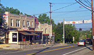
Centreville is a village in the U.S. state of Michigan and the county seat of St. Joseph County. The population was 1,425 at the 2010 census.
Pace is a town in Bolivar County, Mississippi, United States. Per the 2020 census, the population was 183.
Mount Hope is a town in the northwestern part of Orange County, New York, United States, west of Middletown. The northern town line is the border of Sullivan County. The population was 6,537 at the 2020 census.
Pine Bush is a hamlet located in the town of Crawford and adjacent to Shawangunk, New York, within Orange and adjacent to Ulster counties in the U.S. It is roughly coterminous with the 12566 ZIP code and 744 telephone exchange in the 845 area code. These both extend into adjacent regions of the town of Shawangunk in Ulster County.. The population was 1,751 at the 2020 census.
Unionville is a village in Orange County, New York, United States. The population was 592 at the 2020 census, making it by far the smallest village in Orange County and one of the smallest in New York State.
Mamakating is a town in the southeastern section of Sullivan County, New York, United States. The population was 12,655 at the 2020 census.
Rockland is a town in the northern part of Sullivan County, New York, United States. At the 2020 census, the population was 3,290.
Thompson is a town in the southern part of Sullivan County, New York, United States. The population was 16,550 at the 2020 census. The town is named after William Thompson, an early settler.
Walker Valley is a hamlet located in the western part of the Town of Shawangunk in Ulster County, New York, United States, generally thought of as coterminous with the 12588 ZIP code. The population was 1,269 at the 2020 census.
Wawarsing is a town in Ulster County, New York, United States. The population was 12,771 at the 2020 census. The name Wawarsing was once believed to mean "a place where the streams wind" in the Lenape language, referring to the geography in the hamlet of Wawarsing. Specifically, the joining of the Ver Nooy Kill and the Rondout Creek at Port Ben. The name Wawarsing was used by the Lenape to designate the current hamlet and the fields to the north and south of it for at least six miles in both directions. It is the only Lenape name known to refer to an exact location in Ulster County.
Bloomingburg is a village in Fayette County, Ohio, United States. The population was 878 at the 2020 census.
New Boston is a village in Scioto County, Ohio, United States, along the Ohio River. The population was 2,298 at the 2020 census. Apart from its southern boundary on the Ohio River, New Boston is entirely surrounded by the city of Portsmouth.
Bloomdale is a village in Wood County, Ohio, United States. The population was 665 at the 2020 census.
Wakefield-Peacedale is a census-designated place (CDP) in the town of South Kingstown in Washington County, Rhode Island, United States that includes the villages of Peace Dale and Wakefield. The population was 8,487 at the 2010 census.
Hamilton is a town in Madison County, New York, United States. The population was 6,379 at the 2020 census. The town is named after American Founding Father Alexander Hamilton, and is a college town, with Colgate University dominating the town's employment, culture and population.
Liberty is a village in Sullivan County, New York, United States. The population was 4,700 at the 2020 census.
Pike is a hamlet and census-designated place within the Town of Pike in Wyoming County, New York, United States. The population was 371 at the 2010 census. Pike, located near the center of the town at the junction of NY 19 and NY 39, was a village from 1848 to 2009. The Wyoming County Fairgrounds are in the hamlet.
Plattekill is a town in Ulster County, New York, United States. The population was 10,424 in 2020, a slight decrease from 10,499 at the 2010 census. The name is derived from a stream, the Platte Kill.
Media related to Bloomongburg, New York at Wikimedia Commons