Brimbank Park

Last updated

Brimbank Park
Brimbank Park.jpg
Brimbank Park overlooking the Maribyrnong River
Brimbank Park
TypeMetropolitan park
Location Keilor East, Victoria, Australia
Coordinates 37°44′02″S144°50′13″E / 37.734°S 144.837°E / -37.734; 144.837
Area328.7 hectares (3.29 km2) [1]
Opened1976
Managed by Parks Victoria

Brimbank Park is a metropolitan regional park managed by Parks Victoria situated in the north-western Melbourne suburb of Keilor East, Victoria, Australia.

Contents

History

About 40,000 years ago: first signs of possible human habitation along the Maribyrnong River. The Keilor Cranium and femur of a person, found in 1940 in a sand bank, has been carbon dated at about 12,000 years. [2]

In the late 1830s, Europeans first settled the area and used the fertile river valley as stock runs. They often drove stock around the brim of the bank, thus the park's name, Brimbank. The river flats on the east bank were used for market gardening until 1983. [3]

In 1976, Brimbank Park opened to the public as part of the Maribyrnong Valley Park, combined with the adjacent Horseshoe Bend Children's farm and Greenvale Reservoir Park. The Maribyrnong River has hollowed out a valley some 55 metres below the Keilor Plain, with a steep bank on the northern side and gentle terraces on the southern side. [4]

In 2016, the park was implemented a Victorian-first pilot project to help children on the autism spectrum play more freely, with Parks Victoria creating a digital "script" showing items and sights they would encounter at the park. This was designed to alleviate anxiety, particularly when moving from one place to another, and was designed alongside autism advocacy organisation Amaze. [5] [6]

In 2021, Parks Victoria began helping plant trees at the park as part of the "More Trees for a Cooler, Greener West" project which aims to plant trees in urban areas of Melbourne's western suburbs with the lowest tree canopy covers. This was done to help increase urban shade cover with phase two commencing in 2022 and stage three completed by mid-2023. [7]

Features

The park fields recreational activities with facilities including walking and cycling tracks, playgrounds, picnic areas, amenities and a café. [8] The park is located along Old Calder Highway with an entrance off Keilor Park Drive.

The Maribyrnong River flows through the park, which holds as one end of the 25km Maribyrnong River Trail. At Keilor, the river winds back on itself in a horseshoe bend, before winding south again at Brimbank Park. Brimbank Park is home to wildlife including swamp wallabies, blue tongued lizards and echidnas. Birds including parrots, herons, galahs, blue wrens, yellow-tailed thornbills, rosellas, flame robins and the peregrine falcon can also be seen in the park. [4]

Related Research Articles

<span class="mw-page-title-main">City of Brimbank</span> Local government area in Victoria, Australia

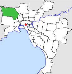
The City of Brimbank is a local government area located within the metropolitan area of Melbourne, Victoria, Australia. It comprises the western suburbs between 10 and 20 km west and northwest from the Melbourne city centre.

<span class="mw-page-title-main">Maribyrnong, Victoria</span> Suburb of Melbourne, Victoria, Australia

Maribyrnong is an inner-city suburb in Melbourne, Victoria, Australia, 8 km (5.0 mi) north-west of Melbourne's Central Business District, located within the City of Maribyrnong local government area. Maribyrnong recorded a population of 12,573 at the 2021 census.

<span class="mw-page-title-main">Maribyrnong River</span> River in Melbourne, Victoria, Australia

The Maribyrnong River is a perennial river of the Port Phillip catchment, located in the north–western suburbs of Melbourne, in the Australian state of Victoria.

<span class="mw-page-title-main">Essendon, Victoria</span> Suburb of Melbourne, Victoria, Australia

Essendon is a suburb in Melbourne, Victoria, Australia, 8 km (5.0 mi) north-west of Melbourne's central business district, located within the City of Moonee Valley local government area. Essendon recorded a population of 21,240 at the 2021 census.

<span class="mw-page-title-main">Niddrie, Victoria</span> Suburb of Melbourne, Victoria, Australia

Niddrie is a suburb in Melbourne, Victoria, Australia, 11 km (6.8 mi) north-west of Melbourne's Central Business District, located within the City of Moonee Valley local government area. Niddrie recorded a population of 5,901 at the 2021 census.

<span class="mw-page-title-main">Keilor, Victoria</span> Suburb of Melbourne, Victoria, Australia

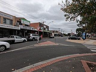
Keilor is a suburb in Melbourne, Victoria, Australia, 16 km (9.9 mi) north-west of Melbourne's Central Business District, located within the Cities of Brimbank and Hume local government areas. Keilor recorded a population of 5,906 at the 2021 census.

Keilor Downs is a suburb in Melbourne, Victoria, Australia, 18 km (11 mi) north-west of Melbourne's Central Business District, located within the City of Brimbank local government area. Keilor Downs recorded a population of 9,857 at the 2021 census.

<span class="mw-page-title-main">Maribyrnong River Trail</span>

The Maribyrnong River Trail is a shared use path for cyclists and pedestrians, which follows the Maribyrnong River through the north western suburbs of Melbourne, Victoria, Australia.

<span class="mw-page-title-main">Avondale Heights</span> Suburb of Melbourne, Victoria, Australia

Avondale Heights is a suburb in Melbourne, Victoria, Australia, 11 km (6.8 mi) north-west of Melbourne's Central Business District, located within the City of Moonee Valley local government area. Avondale Heights recorded a population of 12,388 at the 2021 census.

<span class="mw-page-title-main">Keilor Park, Victoria</span> Suburb of Melbourne, Victoria, Australia

Keilor Park is a suburb in Melbourne, Victoria, Australia, 15 km (9.3 mi) north-west of Melbourne's Central Business District, located within the City of Brimbank local government area. Keilor Park recorded a population of 2,684 at the 2021 census.

<span class="mw-page-title-main">Parks and gardens of Melbourne</span> Parks and gardens in Melbourne, VIC, Australia

Melbourne is Australia's second largest city and widely considered to be a garden city, with Victoria being nicknamed "the Garden State". Renowned as one of the most livable cities in the world, there is an abundance of parks, gardens and green belts close to the CBD with a variety of common and rare plant species amid landscaped vistas, pedestrian pathways, and tree-lined avenues, all managed by Parks Victoria.

<span class="mw-page-title-main">Keilor East, Victoria</span> Suburb of Melbourne, Victoria, Australia

Keilor East is a suburb in Melbourne, Victoria, Australia, 13 km (8.1 mi) north-west of Melbourne's Central Business District, located within the Cities of Brimbank and Moonee Valley local government areas. Keilor East recorded a population of 15,073 at the 2021 census.

The Taylors Creek Trail is a shared use path for cyclists and pedestrians, which follows Taylors Creek in the outer north-west suburb of Taylors Lakes in Melbourne, Victoria, Australia.

<span class="mw-page-title-main">City of Keilor</span> Local government area in Victoria, Australia

The City of Keilor was a local government area about 13 kilometres (8 mi) northwest of Melbourne, the state capital of Victoria, Australia. The city covered an area of 99.70 square kilometres (38.49 sq mi), and existed from 1863 until 1994.

Horseshoe Bend Farm is a 26 hectares (0.10 sq mi) park in the western suburbs of Melbourne, Australia, adjacent to Brimbank Park on the Maribyrnong River. Formerly a commercial farm, it is now managed by Parks Victoria, but no longer has any livestock. An original 1930s weatherboard cottage still exists on the site. Previously the park was closed for nearly five years but has recently opened again.

<span class="mw-page-title-main">Organ Pipes National Park</span> Protected area in Victoria, Australia

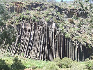
The Organ Pipes National Park, abbreviated as OPNP, is a national park located in the Central region of Victoria, Australia. The 121-hectare (300-acre) protected area was established with the focus on conservation of the native flora and fauna, and preservation of the geological features in the Jacksons Creek, a part of the Maribyrnong valley, north-west of Melbourne. It is situated in a deep gorge in the grassy, basalt Keilor Plains.

The Keilor archaeological site was among the first places to demonstrate the antiquity of Aboriginal occupation of Australia when a cranium, unearthed in 1940, was found to be nearly 15,000 years old. Subsequent investigations of Pleistocene alluvial terraces revealed hearths about 31,000 years BP, making Keilor one of the earliest sites of human habitation in Australia. Remains of megafauna suggest a possible association with Aboriginal hunting.

<span class="mw-page-title-main">Woiwurrung</span>

The Woiwurrung, also spelt Woi-wurrung, Woi Wurrung, Woiwurrong, Woiworung, Wuywurung, are an Aboriginal Australian people of the Woiwurrung language group, in the Kulin alliance.

The western suburbs is the metropolitan area directly west of the Melbourne Central Business District in Melbourne, Victoria, Australia.

References

  1. Jake Kyle Day; Ashok K Sharma (November 2020), "Stormwater harvesting infrastructure systems design for urban park irrigation: Brimbank Park, Melbourne case study", Journal of Water Supply: Research and Technology-Aqua, 69 (8): 847, doi: 10.2166/aqua.2020.047 , retrieved 5 July 2022
  2. Paleoanthropology—Keilor Cranium Archived December 17, 2004, at the Wayback Machine
  3. "Brimbank Park (Keilor East)". MelbournePlaygrounds. Retrieved 23 January 2022.
  4. 1 2 Laura Mullins (10 May 2016). "Brimbank Park". Environment Victoria. Retrieved 23 January 2022.
  5. Miki Perkins (22 July 2016). "Autism-friendly park: Brimbank welcome for kids who like to follow the script". The Age. Retrieved 24 January 2022.
  6. "Brimbank Park project chosen to help children with autism". Brimbank & North West Star Weekly . 3 August 2016. Retrieved 24 January 2022.
  7. Tara Murray (7 January 2022). "Tree planting underway". Brimbank & North West Star Weekly. Retrieved 24 January 2022.
  8. "Brimbank Park Visitor Guide" (PDF). Parks Victoria. Retrieved 23 January 2022.