
Sir Douglas Mawson was a British-born Australian geologist, Antarctic explorer, and academic. Along with Roald Amundsen, Robert Falcon Scott, and Sir Ernest Shackleton, he was a key expedition leader during the Heroic Age of Antarctic Exploration.

Mawson Station, commonly called Mawson, is one of three permanent bases and research outposts in Antarctica managed by the Australian Antarctic Division (AAD). Mawson lies in Holme Bay in Mac. Robertson Land, East Antarctica in the Australian Antarctic Territory, a territory claimed by Australia. Established in 1954, Mawson is Australia's oldest Antarctic station and the oldest continuously inhabited Antarctic station south of the Antarctic Circle. It houses approximately 20 personnel over winter and up to 53 in summer.

The Scullin Monolith is a crescent-shaped rock fronting the sea 6 km (3.7 mi) west of the similar Murray Monolith, and 8 km (5.0 mi) from Torlyn Mountain, in Mac. Robertson Land, Antarctica. It is a steep massif of metasedimentary gneiss and granitic origin, with the adjacent coastline consisting of 40 m high ice cliffs. The monolith rises steeply to extend from 435 m high Mikkelsen Peak westward in a crescent that forms Douglas Bay.

Mawson Peak is an active volcanic summit of the Big Ben massif on Heard Island, an external Australian territory in the Indian Ocean.
Welch Island is an island, 1.8 km (1.1 mi) long with a prominent pinnacle rock of 130 m (427 ft), lying north of the Rouse Islands and 2 km (1.2 mi) off the eastern side of Holme Bay in Mac. Robertson Land, Antarctica. It lies 1 km (0.6 mi) south of Welch Rocks.

Mac. Robertson Land is the portion of Antarctica lying southward of the coast between William Scoresby Bay and Cape Darnley. It is located at 70°00′S65°00′E. In the east, Mac. Robertson Land includes the Prince Charles Mountains. It was named by the British Australian and New Zealand Antarctic Research Expedition (BANZARE) (1929–1931), under Sir Douglas Mawson, after Sir Macpherson Robertson of Melbourne, a patron of the expedition.
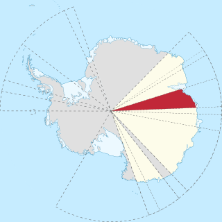
Princess Elizabeth Land is the sector of Antarctica between longitude 73° east and Cape Penck. The sector is claimed by Australia as part of the Australian Antarctic Territory, although this claim is not widely recognised.
The Rouse Islands or Rouse Rocks are a small group of islands in the eastern part of Holme Bay in Antarctica, fringing the coast of Mac Robertson Land close south of Welch Island. The Rouse Islands have an elevation of 28 m (92 ft). The Rouse Islands were discovered on February 13, 1931, by the British Australian and New Zealand Antarctic Research Expedition (BANZARE) under Sir Douglas Mawson, who named them for E. J. Rouse of Sydney, who assisted the expedition with photographic equipment. The Rouse Islands have since been found to be islands.
The Mawson Coast is that portion of the coast of Mac. Robertson Land, Antarctica, lying between William Scoresby Bay, at 59°34′E, and Murray Monolith, at 66°54′E. The coast was sighted during the British Australian New Zealand Antarctic Research Expedition (BANZARE), 1929–30, under Sir Douglas Mawson. Further exploration and landings at Cape Bruce and Scullin Monolith were made during BANZARE, 1930–31. Mawson Coast was named by the Antarctic Names Committee of Australia after Mawson in recognition of his great contribution to Antarctic exploration.
The Framnes Mountains is a group of Antarctic mountain ranges in Mac. Robertson Land, to the south of the Mawson Coast. The range is surrounded by, and largely covered by, an ice sheet.
Aagaard Islands also known as Bjarne Aagaard Islands or Ostrova B'yarne-Ogor, are a group of small islands lying to the west of Proclamation Island and Cape Batterbee, near the coast of Antarctica in the Southern Ocean. They were discovered in January 1930 by the British Australian and New Zealand Antarctic Research Expedition (BANZARE) under Sir Douglas Mawson, and were named after Bjarne Aagaard.
Murray Monolith is a detached part of Torlyn Mountain in Mac.Robertson Land, Antarctica. It is a steep massif of metasedimentary gneiss and granitic origin, with the adjacent coastline consisting of 40 m high ice cliffs. The monolith is dome-shaped with steep sides, rising to a seaward summit of 339 m and an inland summit of 363 m at Torlyn Mountain.

Proclamation Island is a small rocky island 2.5 nautical miles west of Cape Batterbee and close east of the Aagaard Islands of Antarctica.
Cape Bruce forms the northern tip of a small island lying at the eastern side of Oom Bay, separated from the mainland rocks just west of Taylor Glacier in Mac. Robertson Land, Antarctica.

The Masson Range is a high broken chain of mountains, consisting primarily of the North Masson, Central Masson and South Masson Ranges, forming a part of the Framnes Mountains.
Dingsør Dome is a small, distinct ice-covered elevation rising inland from the coast, 11 nautical miles (20 km) south of Point Williams, in Mac. Robertson Land. It was discovered in February 1931 by the British Australian and New Zealand Antarctic Research Expedition (1929–31) under Douglas Mawson, and was named by Mawson after Captain Dingsør, a Norwegian whale fishery inspector who was aboard the Kosmos in Antarctica that season. The Kosmos had supplied coal to Mawson's ship, the Discovery, on December 29, 1930.
The Gustav Bull Mountains are a small group of bare, rugged mountain peaks and nunataks, lying 4 miles (6 km) inland from the coast and 10 nautical miles (19 km) southwest of Scullin Monolith in Mac. Robertson Land, Antarctica.
Mount Henderson is a mountain in the Framnes Mountains of Mac. Robertson Land in the Antarctic. It is southeast of Holme Bay and northeast of the Masson Range.
Mount Rivett is a bare rock mountain, the northeasternmost feature of the Gustav Bull Mountains in Mac. Robertson Land, Antarctica. On February 13, 1931, the British Australian New Zealand Antarctic Research Expedition (BANZARE) (1929–31) under Douglas Mawson made a landing on nearby Scullin Monolith. They named this mountain after Sir David Rivett, Deputy Chairman and Chief Executive Officer of the Australian Council for Scientific and Industrial Research, 1927–45.
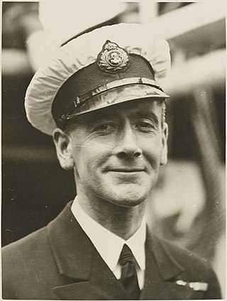
Kenneth Norman MacKenzie was an officer in the merchant fleet known for his role in the British Australian and New Zealand Antarctic Research Expedition, for which he was awarded a Polar Medal.

