
The BT Tower is a grade II listed communications tower in Fitzrovia, London, England, owned by BT Group. It was also known as the GPO Tower and the Post Office Tower. It was later officially renamed the Telecom Tower. The main structure is 581 feet (177 m) high, with a further section of aerial rigging bringing the total height to 620 feet (189 m).

Tropospheric scatter, also known as troposcatter, is a method of communicating with microwave radio signals over considerable distances – often up to 500 kilometres (310 mi) and further depending on frequency of operation, equipment type, terrain, and climate factors. This method of propagation uses the tropospheric scatter phenomenon, where radio waves at UHF and SHF frequencies are randomly scattered as they pass through the upper layers of the troposphere. Radio signals are transmitted in a narrow beam aimed just above the horizon in the direction of the receiver station. As the signals pass through the troposphere, some of the energy is scattered back toward the Earth, allowing the receiver station to pick up the signal.
Telecommunications towers in the United Kingdom are operated mainly by Arqiva. Arqiva operates the transmitters for UK terrestrial TV and most radio broadcasting, both analogue and digital. BT also operates a number of telecommunications towers in the UK.

Chain Home, or CH for short, was the codename for the ring of coastal early warning radar stations built by the Royal Air Force (RAF) before and during the Second World War to detect and track aircraft. Initially known as RDF, and given the official name Air Ministry Experimental Station Type 1 in 1940, the radar units were also known as Chain Home for most of their life. Chain Home was the first early warning radar network in the world and the first military radar system to reach operational status. Its effect on the war made it one of the most powerful systems of what became known as the "Wizard War".

Royal Air Force Menwith Hill is a Royal Air Force station near Harrogate, North Yorkshire, England, which provides communications and intelligence support services to the United Kingdom and the United States. The site contains an extensive satellite ground station and is a communications intercept and missile warning site. It has been described as the largest electronic monitoring station in the world.

ROTOR was an elaborate air defence radar system built by the British Government in the early 1950s to counter possible attack by Soviet bombers. To get it operational as quickly as possible, it was initially made up primarily of WWII-era systems, notably the original Chain Home radars for the early warning role, and the AMES Type 7 for plotting and interception control. Data from these stations was sent to a network of control stations, mostly built underground, using an extensive telephone and telex network.

Rugby Radio Station was a large British government radio transmission facility just east of the Hillmorton area of the town of Rugby, Warwickshire in England. The site straddled the A5 trunk road, with most of it in Warwickshire, and part on the other side of the A5 in Northamptonshire. First opened in 1926, at its height in the 1950s it was the largest radio transmitting station in the world, with a total of 57 radio transmitters, covering an area of 1,600 acres (650 ha). Traffic slowly dwindled from the 1980s onwards, and the site was closed between 2003 and 2007.

Ground-controlled interception (GCI) is an air defence tactic whereby one or more radar stations or other observational stations are linked to a command communications centre which guides interceptor aircraft to an airborne target. This tactic was pioneered during World War I by the London Air Defence Area organization, which became the Royal Air Force's Dowding system in World War II, the first national-scale system. The Luftwaffe introduced similar systems during the war, but most other combatants did not suffer the same threat of air attack and did not develop complex systems like these until the Cold War era.

The BT Tower, formerly known as the Post Office Tower and the GPO Tower, is a landmark and telecommunications tower in Birmingham, England. It is the tallest structure in the city. Its post office code was YBMR.
A BT site engineering code is a group of letters assigned by BT, or its predecessor the General Post Office, to a physical location which is equipped by the company with unusual amounts or types of telecommunications.

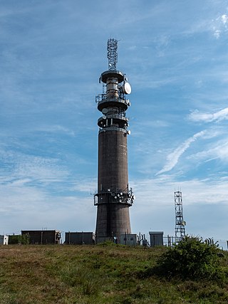
Pye Green BT Tower is a 96.9-metre (318 ft) tall telecommunication tower built of reinforced concrete at Pye Green, Staffordshire, England. Standing on the far southern edge of Cannock Chase, it is one of 14 telecommunication towers in the United Kingdom built of reinforced concrete. Pye Green was constructed as part of the British Cold War "Backbone" radio communications network.
Sutton Common BT Tower is a 72-metre (238-foot) radio tower built of reinforced concrete at Macclesfield, Cheshire, England. Sutton Common was originally conceived as part of the 1950s 'Backbone' chain designed to provide the UK and NATO with survivable communications during nuclear war.

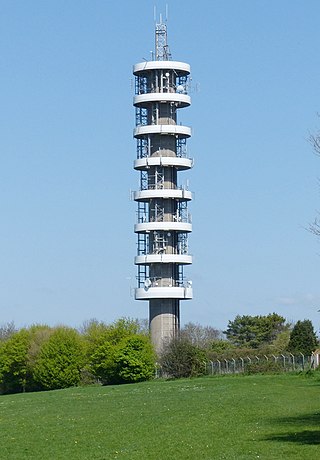
The Heaton Park BT Tower is a 238-foot (73 m) tall concrete telecommunications tower located next to Heaton Park Reservoir in Manchester, England. Heaton Park BT Tower is one of the few British towers built of reinforced concrete, and one of seven BT towers of the 'Chilterns' design.

The Tinshill BT Tower is a 60.96 metres ( 200 ft) tall telecommunication tower located on the east side of Otley Old Road in the north of Leeds, West Yorkshire, England. It is in an elevated part of Leeds, with its base 192 metres above sea level. It is one of fourteen BT towers built of reinforced concrete.
Linesman/Mediator was a dual-purpose civil and military radar network in the United Kingdom between the 1960s and 1984. The military side (Linesman) was replaced by the Improved United Kingdom Air Defence Ground Environment (IUKADGE), while the civilian side (Mediator) became the modern public-private National Air Traffic Services (NATS).

Microwave transmission is the transmission of information by electromagnetic waves with wavelengths in the microwave frequency range of 300 MHz to 300 GHz of the electromagnetic spectrum. Microwave signals are normally limited to the line of sight, so long-distance transmission using these signals requires a series of repeaters forming a microwave relay network. It is possible to use microwave signals in over-the-horizon communications using tropospheric scatter, but such systems are expensive and generally used only in specialist roles.
Trans Canada Microwave or Trans-Canada Skyway was a microwave relay system built in the 1950s to carry telephone and television signals from Canada's east coast to its west coast. Built across the nation, the towers ranged in height from nine metres high, to one in northern Ontario that was over 100 metres high. The system included 139 towers spanning over 6,275 kilometres and cost $50 million.

The North Atlantic Radio System (NARS) was a chain of 5 tropospheric scatter communication sites. It was an expansion of the former Distant Early Warning Line. NARS was built for the United States Air Force (USAF) by Western Electric (AT&T) and its sites were maintained under contract by ITT Federal Electric Corporation. All NARS stations were supervised and controlled by the USAF, by agreement with the Canadian and Danish Governments.

The AMES Type 7, also known as the Final GCI, was a ground-based radar system introduced during World War II by the Royal Air Force (RAF). The Type 7 was the first truly modern radar used by the Allies, providing a 360 degree view of the airspace around the station out to a distance of about 90 miles (140 km). It allowed fighter interceptions to be plotted directly from the radar display, a concept known as ground controlled intercept, or GCI.

Pole Vault was the first operational tropospheric scatter communications system. It linked radar sites and military airfields in Greenland and eastern Canada by telephone to send aircraft tracking and warning information across North America. The line stretched from Thule Air Force Base in northern Greenland, to Baffin Island and then along the eastern coast of Labrador and Newfoundland to St. John's for connection into existing commercial telecommunications networks.
