Brodhead, Wisconsin

Last updated

Brodhead, Wisconsin
Rock County Wisconsin Incorporated and Unincorporated areas Brodhead Highlighted.svg
Location of Brodhead in Rock County, Wisconsin
Coordinates: 42°37′7″N89°22′35″W / 42.61861°N 89.37639°W / 42.61861; -89.37639
Country Flag of the United States.svg  United States
State Flag of Wisconsin.svg  Wisconsin
Counties Green, Rock
Government
  MayorCasey Jones
Area
[1]
  Total1.79 sq mi (4.65 km2)
  Land1.79 sq mi (4.65 km2)
  Water0.00 sq mi (0.00 km2)
Elevation
[2]
794 ft (242 m)
Population
 (2020) [3]
  Total3,274
  Density1,808.91/sq mi (698.49/km2)
Time zone UTC-6 (Central (CST))
  Summer (DST) UTC-5 (CDT)
Zip Code
53520
Area code 608
FIPS code 55-09925 [4]
GNIS feature ID1562229 [2]
Website cityofbrodheadwi.us

Brodhead is a city in Green and Rock counties in the U.S. state of Wisconsin. The population was 3,274 at the 2020 census. In February 2000, the city annexed a portion of land from the Town of Spring Valley in Rock County.

Contents

History

Just south of town is a historic marker for the Half-Way Tree, a bur oak supposedly identified by Native Americans as the halfway point on a foot trail between Lake Michigan and the Mississippi River. [5] Present day experts say the tree is off by about six miles but there is also a disagreement about the methods of measurement. [6] The half-way tree still stands protected and still marks the half-way point.

The railroad track that runs east and west through town features a small museum with a train and army tank on display, adjacent to the park and bandstand pavilion. The museum curator said that the railroad was being wooed by two different towns and decided to split the difference and created Brodhead in the spring of 1856.

The town was named in honor of the chief engineer of the Milwaukee and Mississippi Railroad, Edward Hallock Brodhead (1809–1890), who was among the earliest promoters of the railway depot. The initial street names of the town were platted after the surnames of the landowners, eventually changed to numerical titles to reflect practical purposes. [7]

Other cofounders include: Edmund Deacon Clinton (1804–1885), Isaac Foster Mack (1806–1886), John P. Dixon, John Lucas Vischer Thomas (1825–1917), John L. McNair (1809–1877), Edmund Abbott West (1823–1922) and Erastus M. Smith.

A nearby raceway was dredged off of a branch of the Sugar River that diverted a long canal to a hydroelectric generator that supplied electricity to the town. This gave Brodhead the distinction of having electrical service before other larger cities such as Chicago, and perhaps the first electrical service in Wisconsin.[ citation needed ]

Geography

Brodhead is located at 42°37′7″N89°22′35″W / 42.61861°N 89.37639°W / 42.61861; -89.37639 (42.618540, -89.376291). [8]

According to the United States Census Bureau, the city has a total area of 1.84 square miles (4.77 km2), all of it land. [9]

Climate

According to the Köppen Climate Classification system, Brodhead has a hot-summer humid continental climate, abbreviated "Dfa" on climate maps. The hottest temperature recorded in Brodhead was 111 °F (43.9 °C) on July 21, 1901 and July 1214, 1936, while the coldest temperature recorded was −36 °F (−37.8 °C) on January 30, 1951. [10]

Climate data for Brodhead, Wisconsin, 1991–2020 normals, extremes 1897–present
MonthJanFebMarAprMayJunJulAugSepOctNovDecYear
Record high °F (°C)61
(16)
71
(22)
84
(29)
92
(33)
105
(41)
109
(43)
111
(44)
103
(39)
102
(39)
89
(32)
80
(27)
69
(21)
111
(44)
Mean maximum °F (°C)47.6
(8.7)
52.4
(11.3)
67.8
(19.9)
79.4
(26.3)
87.3
(30.7)
92.3
(33.5)
92.7
(33.7)
91.6
(33.1)
88.9
(31.6)
82.1
(27.8)
66.0
(18.9)
51.8
(11.0)
94.9
(34.9)
Mean daily maximum °F (°C)27.4
(−2.6)
31.8
(−0.1)
44.4
(6.9)
58.3
(14.6)
70.1
(21.2)
79.8
(26.6)
83.1
(28.4)
81.3
(27.4)
74.6
(23.7)
61.6
(16.4)
46.0
(7.8)
32.8
(0.4)
57.6
(14.2)
Daily mean °F (°C)19.0
(−7.2)
22.7
(−5.2)
34.5
(1.4)
46.9
(8.3)
58.6
(14.8)
68.6
(20.3)
72.0
(22.2)
70.1
(21.2)
62.4
(16.9)
50.2
(10.1)
36.9
(2.7)
25.0
(−3.9)
47.2
(8.5)
Mean daily minimum °F (°C)10.5
(−11.9)
13.6
(−10.2)
24.6
(−4.1)
35.4
(1.9)
47.1
(8.4)
57.4
(14.1)
61.0
(16.1)
58.9
(14.9)
50.1
(10.1)
38.8
(3.8)
27.8
(−2.3)
17.2
(−8.2)
36.9
(2.7)
Mean minimum °F (°C)−11.8
(−24.3)
−6.8
(−21.6)
4.6
(−15.2)
23.2
(−4.9)
33.7
(0.9)
44.8
(7.1)
51.0
(10.6)
49.2
(9.6)
36.9
(2.7)
25.5
(−3.6)
12.2
(−11.0)
−3.9
(−19.9)
−16.1
(−26.7)
Record low °F (°C)−36
(−38)
−35
(−37)
−21
(−29)
7
(−14)
24
(−4)
33
(1)
40
(4)
35
(2)
20
(−7)
2
(−17)
−18
(−28)
−30
(−34)
−36
(−38)
Average precipitation inches (mm)1.59
(40)
1.75
(44)
2.11
(54)
3.73
(95)
4.18
(106)
5.56
(141)
4.00
(102)
4.35
(110)
3.78
(96)
2.94
(75)
2.35
(60)
1.96
(50)
38.30
(973)
Average snowfall inches (cm)10.3
(26)
9.3
(24)
4.5
(11)
0.9
(2.3)
0.1
(0.25)
0.0
(0.0)
0.0
(0.0)
0.0
(0.0)
0.0
(0.0)
0.3
(0.76)
2.2
(5.6)
9.7
(25)
37.3
(94.91)
Average precipitation days (≥ 0.01 in)9.68.49.812.013.312.29.99.99.09.68.69.8122.1
Average snowy days (≥ 0.1 in)6.95.73.00.70.00.00.00.00.00.21.35.423.2
Source 1: NOAA [11]
Source 2: National Weather Service [10]

Demographics

Historical population
CensusPop.Note
1870 1,548
1880 1,254−19.0%
1890 1,46116.5%
1900 1,5848.4%
1910 1,517−4.2%
1920 1,6005.5%
1930 1,533−4.2%
1940 1,75014.2%
1950 2,01615.2%
1960 2,44421.2%
1970 2,5152.9%
1980 3,15325.4%
1990 3,1650.4%
2000 3,1800.5%
2010 3,2933.6%
2020 3,274−0.6%
U.S. Decennial Census [12]

As of 2000 the median income for a household in the city was $36,506, and the median income for a family was $46,199. Males had a median income of $32,031 versus $24,442 for females. The per capita income for the city was $17,455. About 6.6% of families and 7.3% of the population were below the poverty line, including 4.1% of those under age 18 and 5.8% of those age 65 or over.

2010 census

As of the census [3] of 2010, there were 3,293 people, 1,346 households, and 851 families residing in the city. The population density was 1,789.7 inhabitants per square mile (691.0/km2). There were 1,452 housing units at an average density of 789.1 per square mile (304.7/km2). The racial makeup of the city was 96.4% White, 0.1% African American, 0.3% Native American, 0.5% Asian, 1.9% from other races, and 0.8% from two or more races. Hispanic or Latino people of any race were 3.8% of the population.

There were 1,346 households, of which 32.3% had children under the age of 18 living with them, 46.8% were married couples living together, 11.4% had a female householder with no husband present, 5.1% had a male householder with no wife present, and 36.8% were non-families. 31.1% of all households were made up of individuals, and 14% had someone living alone who was 65 years of age or older. The average household size was 2.41 and the average family size was 3.01.

The median age in the city was 38.4 years. 25% of residents were under the age of 18; 7.9% were between the ages of 18 and 24; 26.1% were from 25 to 44; 23.3% were from 45 to 64, and 17.6% were 65 years of age or older. The gender makeup of the city was 47.3% male and 52.7% female.

Education

Brodhead is served by the Brodhead School District. There are 1,039 students in the district with grades Pre-K through 5th attending Albrecht Elementary school. [13] Grades 6 through 8 attend Brodhead Middle School. Brodhead High School is the local high school. [14] The high school is located at 2501 W 5th AVE Brodhead, WI 53520. Brodhead school district also has a student-teacher ratio of 13:1.

Transportation

Wisconsin State Highways

Railroads

The Wisconsin and Southern Railroad runs through town on the branch line to Monroe.

Notable people

Related Research Articles

<span class="mw-page-title-main">Morrison, Wisconsin</span> Town in Wisconsin, United States

Morrison is a town in Brown County in the U.S. state of Wisconsin. The population was 1,599 at the 2010 census.

<span class="mw-page-title-main">Pleasant Springs, Wisconsin</span> Town in Wisconsin, United States

The Town of Pleasant Springs is located in Dane County, Wisconsin, United States. The population was 3,053 at the 2000 census. The unincorporated community of Kegonsa is located in the town. The unincorporated community of Hoffman Corners is also located partially in the town.

<span class="mw-page-title-main">Vienna, Wisconsin</span> Town in Wisconsin, United States

Vienna is a town in Dane County, Wisconsin, United States. The population was 1,666 at the 2020 census. The unincorporated community of Norway Grove is located in the town.

<span class="mw-page-title-main">LeRoy, Wisconsin</span> Town in Wisconsin, United States

LeRoy is a town in Dodge County, Wisconsin, United States. The population was 1,116 at the 2000 census. The unincorporated communities of Farmersville and LeRoy are located in the town.

<span class="mw-page-title-main">Beetown, Wisconsin</span> Town in Wisconsin, United States

The Town of Beetown is located in Grant County, Wisconsin, United States. The population was 734 at the 2000 census. The unincorporated communities of Beetown, Diamond Grove, Five Points, Flora Fountain, Hurricane, and North Andover are located in the town. The former community of Pleasant Ridge was also located in the town.

<span class="mw-page-title-main">Markesan, Wisconsin</span> City in Wisconsin, United States

Markesan is a city in Green Lake County, Wisconsin, United States. The population was 1,476 at the 2010 census. The center of population of Wisconsin is located in Markesan.

<span class="mw-page-title-main">Delton, Wisconsin</span> Town in Wisconsin, United States

Delton, originally called New Buffalo, is a town in Sauk County, Wisconsin, United States. The population was 2,024 at the 2000 census.

<span class="mw-page-title-main">Scott, Sheboygan County, Wisconsin</span> Town in Wisconsin, United States

Scott is a town in Sheboygan County, Wisconsin, United States. The population was 1,804 at the 2000 census. The unincorporated communities of Batavia, Beechwood, and Cranberry Marsh are located within the town. It is included in the Sheboygan, Wisconsin Metropolitan Statistical Area.

<span class="mw-page-title-main">Union, Vernon County, Wisconsin</span> Town in Wisconsin, United States

Union is a town in Vernon County, Wisconsin, United States. The population was 531 at the 2000 census. The unincorporated community of White City is located in the town.

<span class="mw-page-title-main">Bloomfield, Walworth County, Wisconsin</span> Town in Wisconsin, United States

Bloomfield is a town in Walworth County, Wisconsin, United States. The population was 1,778 at the 2020 census. The village of Bloomfield was formed from part of the town on December 20, 2011. The census-designated place of Lake Ivanhoe and unincorporated community of North Bloomfield are located in the town.

<span class="mw-page-title-main">Plymouth, Sheboygan County, Wisconsin</span> Town in Wisconsin, United States

Plymouth is a town in Sheboygan County, Wisconsin. The population was 3,115 at the time of the 2000 census. It is included in the Sheboygan, Wisconsin Metropolitan Statistical Area. The City of Plymouth is located within the town, but is politically independent. The unincorporated community of New Paris is also located in the town.

<span class="mw-page-title-main">Loyal, Wisconsin</span> City in Wisconsin, United States

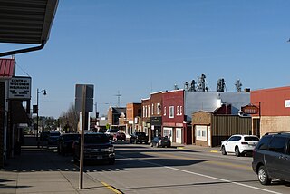
Loyal is a city in Clark County in the U.S. state of Wisconsin. The population was 1,261 at the 2010 census. The city is located within the Town of Loyal, though it is politically independent.

<span class="mw-page-title-main">Columbus, Wisconsin</span> City in Wisconsin, United States

Columbus is a city in Columbia County, Wisconsin (mostly) and Dodge County, Wisconsin Counties in the south-central part of the U.S. state of Wisconsin. The population was 5,484 in the 2022 United States census. All of this population resided in the Columbia County portion of the city. Columbus is located about 28 miles (45 km) northeast of Madison on the Crawfish River. The Columbia County portion of the city lies within the Madison Metropolitan Statistical Area while the Dodge County portion is a part of the Milwaukee-Waukesha-Racine CSA. Nearly all of the city is located within the town of Columbus in Columbia County, though a small portion lies within the town of Elba in Dodge County.

<span class="mw-page-title-main">Beaver Dam, Wisconsin</span> City in Wisconsin, United States

Beaver Dam is a city in Dodge County, Wisconsin, United States, along Beaver Dam Lake and the Beaver Dam River. The population was 16,708 at the 2020 census, making it the largest city primarily located in Dodge County. It is the principal city of the Beaver Dam Micropolitan Statistical area which is included in the larger Milwaukee–Waukesha–Racine CSA. The city is adjacent to the Town of Beaver Dam.

<span class="mw-page-title-main">Monroe, Wisconsin</span> City in Wisconsin, United States

Monroe, known as "the Cheese Capital of the USA", is a city in and the county seat of Green County, Wisconsin, United States. The population was 10,661 at the 2020 census. The city is bordered by the town of Monroe to the north and the town of Clarno to the south. Monroe is a part of the Madison Metropolitan Statistical Area

<span class="mw-page-title-main">Montello, Wisconsin</span> City in Wisconsin, United States

Montello is a city in and the county seat of Marquette County, Wisconsin, United States. The population was 1,495 at the 2010 census. The Fox River flows through the city. Montello is home to the largest tree in Wisconsin. A notable attraction in the city is the former granite quarry, which has been transformed into a park with several waterfalls.

<span class="mw-page-title-main">Burlington, Wisconsin</span> City in Wisconsin, United States

Burlington is a city in Racine and Walworth counties in the U.S. state of Wisconsin, with the majority of the city located in Racine County. The population of the city was 11,047 as of the 2020 census.

<span class="mw-page-title-main">Milton, Wisconsin</span> City in Wisconsin, United States

Milton is a city in Rock County, Wisconsin, United States. The population was 5,716 at the 2020 census.

<span class="mw-page-title-main">Medford, Wisconsin</span> City in Wisconsin, United States

Medford is a city and county seat of Taylor County, in north-central Wisconsin, United States. The population was 4,349 at the 2020 census. The city is located mostly within the boundaries of the Town of Medford.

<span class="mw-page-title-main">Pewaukee, Wisconsin</span> City in Wisconsin, United States

Pewaukee is a city in Waukesha County, Wisconsin. The population was 15,914 at the 2020 census. The Village of Pewaukee, which was incorporated out of the town before it incorporated as a city, is surrounded by the city.

References

  1. "2019 U.S. Gazetteer Files". United States Census Bureau. Retrieved August 7, 2020.
  2. 1 2 "US Board on Geographic Names". United States Geological Survey. October 25, 2007. Retrieved January 31, 2008.
  3. 1 2 "U.S. Census website". United States Census Bureau . Retrieved November 18, 2012.
  4. "U.S. Census website". United States Census Bureau . Retrieved January 31, 2008.
  5. JS Online: Don't look too closely at Half-Way Tree's roots Archived March 11, 2007, at the Wayback Machine
  6. "The Half-Way Tree" . Retrieved April 16, 2024.
  7. BrodheadHistory.org has more detail.
  8. "US Gazetteer files: 2010, 2000, and 1990". United States Census Bureau. February 12, 2011. Retrieved April 23, 2011.
  9. "US Gazetteer files 2010". United States Census Bureau. Archived from the original on January 25, 2012. Retrieved November 18, 2012.
  10. 1 2 "NOAA Online Weather Data – NWS Milwaukee". National Weather Service. Retrieved May 4, 2023.
  11. "U.S. Climate Normals Quick Access – Station: Brodhead WWTP, WI". National Oceanic and Atmospheric Administration. Retrieved May 4, 2023.
  12. "Census of Population and Housing". Census.gov. Retrieved June 4, 2015.
  13. "Brodhead School District". Niche. Retrieved April 16, 2024.
  14. "Brodhead school district".
  15. "Brodhead · Wisconsin 53520".
  16. Thax Douglas on laying low in Wisconsin
  17. History of Green County, Wisconsin. Springfield, Ill.: Union Publishing Company. 1884. p.  292.
  18. "M. Stanley Livingston". Archived from the original on August 2, 2014. Retrieved January 9, 2012.
  19. 'Wisconsin Blue Book 1875,' Biographical Sketch of Harvey Thomas Moore, pg. 312
  20. Henry Clay Putnam
  21. 'Wisconsin Blue Book 1883,' Biographical Sketch of Archibald N. Randall, pg. 476-477
  22. 'Wisconsin Blue Book 1881,' Biographical Sketch of Birr Sprague, pg. 511
  23. 'Wisconsin Blue Book 1907, Biographical Sketch of Fred Ties, pg. 1151