California State Route 480

Last updated

California 480.svg

State Route 480

California State Route 480
SR 480 highlighted in red; unbuilt portion highlighted in blue
Route information
Maintained by Caltrans
Existed1968–1991
Embarcadero Freeway
Southeast endI-80 (1961).svg I-80 in San Francisco
Northwest end Broadway in San Francisco
Doyle Drive
Southeast endMarina Boulevard
Major intersections
Northwest endUS 101 (1961 cutout).svgCalifornia 1.svg US 101  / SR 1  / Golden Gate Bridge
Location
Country United States
State California
Counties San Francisco
Highway system
US 466 (1961 cutout).svg US 466 I-505 (1961).svg I-505

State Route 480 (SR 480) was a state highway in San Francisco, California, United States, consisting of the elevated double-decker Embarcadero Freeway (also known as the Embarcadero Skyway), the partly elevated Doyle Drive approach to the Golden Gate Bridge and the proposed and unbuilt section in between. The unbuilt section from Doyle Drive to Van Ness Avenue was to have been called the Golden Gate Freeway and the Embarcadero Freeway as originally planned would have extended from Van Ness along the north side of Bay Street and then along the Embarcadero to the San Francisco-Oakland Bay Bridge.

Contents

The Embarcadero Freeway, which had only been constructed from Broadway along the Embarcadero to the Bay Bridge, was demolished after the 1989 Loma Prieta earthquake, and Doyle Drive was then part of U.S. Route 101, until being replaced in 2015 by the Presidio Parkway. SR 480 was Interstate 480 (I-480), an auxiliary route of the Interstate Highway System, from 1955 to 1965. The entire route was removed in 1991, approximately two years after the earthquake.[ citation needed ]

History

Map of the Embarcadero Freeway (purple) Embarcadero Freeway map.png
Map of the Embarcadero Freeway (purple)
1955 map of the planned Interstates in the San Francisco Bay Area. I-480 would have run along the north side of the city, while I-280 would run south along the peninsula. I-80 was to have run past the east end of I-480 to end at I-280. San Francisco, California 1955 Yellow Book.jpg
1955 map of the planned Interstates in the San Francisco Bay Area. I-480 would have run along the north side of the city, while I-280 would run south along the peninsula. I-80 was to have run past the east end of I-480 to end at I-280.

I-480 (CA).svg

Interstate 480

Location San Francisco, California
Existed1955–1968

Legislative Route 224 (LR 224) was defined in 1947 to connect U.S. Route 101 (US 101, pre-1964 Legislative Route 2) at the intersection of Lombard Street and Van Ness Avenue with US 40 and US 50 (pre-1964 Legislative Route 68) at the west end of the San Francisco–Oakland Bay Bridge (near the Transbay Terminal). Its alignment was roughly along Lombard Street and the Embarcadero.

LR 224, as well as Route 2 (US 101) from Route 224 west to the junction with SR 1 near the Golden Gate Bridge, was added to the Interstate Highway System on September 15, 1955. This included the 1936 Doyle Drive, an early freeway built to access the Golden Gate Bridge. [1] After some discussion, the I-480 number was assigned on November 10, 1958. (I-280, as originally planned, ran south from the west end of I-480 along SR 1, through the MacArthur Tunnel and Golden Gate Park, to join its present alignment in Daly City.)

The original 1955 plan was to extend the Central Freeway as a double-decked structure between Van Ness Avenue and Polk Street north to Clay Street, then as a single-deck depressed freeway north to Broadway, where it would have tunneled under Russian Hill to connect with I-480.

The first section of the Embarcadero Freeway, from the Bay Bridge approach (I-80) near First Street north to Broadway, opened on February 5, 1959. [2] [3] The Clay Street and Washington Street ramps opened in 1965. [4]

The freeway revolt caused the San Francisco Board of Supervisors to pass Resolution 45–59 in January 1959, opposing certain freeways, including the remainder of I-480. The freeway revolt continued after a new freeway plan was proposed in 1964, with a major protest on May 17, 1964–200,000 people rallied in Golden Gate Park against any more new freeways. Poet Kenneth Rexroth spoke at the rally (among others), and folk singer Malvina Reynolds sang (she was most famous for her song "Little Boxes", attacking urban sprawl, which she sang at the anti-freeway rally). [5]

The proposed section as replanned in 1964 would have extended not from the Lombard Street exit of Doyle Drive along Lombard Street as originally planned in 1955, but from the Marina Boulevard exit off Doyle Drive, through the Marina Green and then along the north side of Fort Mason, then along the north side of Bay Street to the Embarcadero and south along the Embarcadero to connect with the Embarcadero Freeway. The section between the Golden Gate Bridge (including an upgraded Doyle Drive) and Van Ness Ave. would have been named the Golden Gate Freeway; the rest of the freeway east of Van Ness Avenue would have been the extended originally planned full length of the Embarcadero Freeway, originally planned to extend from Van Ness Avenue to the San Francisco–Oakland Bay Bridge—going east first down the north side of Bay Street, then going southeast curving around the base of Telegraph Hill and meeting at Broadway, the former end of the actually built section of the Embarcadero Freeway. [6] [7]

In the 1964 renumbering, Route 480 was legally designated for the full route of I-480, including the US 101 concurrency. The route was deleted from the Interstate Highway System in January 1968, and I-280 was rerouted north of Daly City at the same time. The short piece of former I-480 from the junction with new I-280 (previously SR 87) south to the Bay Bridge approach legally became part of I-280 (to allow I-280 to meet I-80), now named the Southern Embarcadero Freeway.[ citation needed ] These changes were made to the state highway system in 1968; the legislative designation of Route 480 was truncated only slightly, with the 5.47 miles (8.80 km) [8] from I-280 to SR 1 remaining, though downgraded to SR 480; this extension of I-280 south (the Junipero Serra Freeway) is considered the southern terminus of Junipero Serra Boulevard.

A direct freeway connection from I-280 to either SR 480 or I-80 was never completed, leaving I-280 terminating in mid-air at Third Street. The Golden Gate Freeway also was never built to connect to Doyle Drive and the Golden Gate Bridge. This left ramp stubs on the Embarcadero Freeway where these connections would have been built near Howard Street and Broadway, respectively. These unbuilt segments caused Caltrans to sign the completed freeway segment from the Bay Bridge approach/I-80 near First Street to The Embarcadero as part of SR 480 instead of I-280, and Doyle Drive to be only signed as part of US 101.

Demise and eventual demolition

Section of the Embarcadero Freeway in front of the Ferry Building during demolition (May 1991) San Francisco-Embarcadero Freeway demolition.jpg
Section of the Embarcadero Freeway in front of the Ferry Building during demolition (May 1991)

In the 1980s, opposition to the Embarcadero Freeway resurfaced in proposals to demolish it. The proposal was put to the voters in 1986 and defeated, opposed in particular by influential Chinatown community organizer Rose Pak, who feared that Chinatown would suffer catastrophic consequences if it lost this fast crosstown connection. [9] [10]

The 1989 Loma Prieta earthquake significantly damaged the structure, causing it to be closed to traffic. The California Department of Transportation (Caltrans) planned to retain and retrofit the freeway. Various groups inside and outside the city supported the Caltrans plan, but there was a significant opinion within the city in favor of removing the freeway. Then-Mayor Art Agnos proposed demolishing the freeway in favor of a boulevard with an underpass at the Ferry Building to allow for a large plaza. [11]

Opposition to demolishing the freeway mounted again, with over 20,000 signatures gathered in attempt to require another city vote. [11] Prior to the earthquake, the Embarcadero Freeway carried approximately 70,000 vehicles daily in the vicinity of the Ferry Building. Another 40,000 vehicles per day used associated ramps at Main and Beale streets. The strongest opposition came from Chinatown, led by Pak, along with other neighborhoods north of downtown. [9] [12] Merchants in Chinatown had suffered a dramatic decline in business in the months immediately following the earthquake and feared that if the freeway was not reopened they would not recover. [13]

Agnos continued to negotiate with federal and state officials to win enough funding to make the demolition practical, arguing that the city would squander "the opportunity of a lifetime" if it allowed the freeway to remain. [12] After months of debate, the Board of Supervisors narrowly voted in favor of demolition by a 6–5 margin. [11] Demolition began on February 27, 1991. [14] That year, Agnos was defeated for re-election as Pak and Chinatown switched their support away from him. [15]

Meanwhile, the state legislature deleted SR 480 from the state's Streets and Highways Code. [16] The northwest section along Doyle Drive was transferred to US 101. [16] The only piece of the Embarcadero Freeway to remain was the beginning of the ramp from the Bay Bridge to Fremont Street, including a short ramp stub that formerly carried traffic to the freeway. This part was rebuilt as part of the Bay Bridge retrofit project (I-280 was never finished to that interchange, and its northern terminus was reconfigured to its present-day King Street on/off ramps in 1997, though I-280's legislative definition still takes it to I-80). [17] In 2003, Caltrans began work on a retrofitting project to replace the western approach to the Bay Bridge. This retrofitting was part of a larger, $6-billion project to upgrade the aging Bay Bridge to modern earthquake standards, which included replacing the entire eastern span. In late 2005, Caltrans began the demolition of the original western approach after traffic was routed onto a temporary bypass structure. The western approach to the Bay Bridge was completed in 2009; the entire project was completed in 2013. As a result of this retrofitting project, all old parts of the approach have been replaced, removing the last traces of the Embarcadero Freeway. [18] The Doyle Drive Replacement Project, completed in stages between 2012 and 2015, then replaced Doyle Drive with an entirely new freeway segment called Presidio Parkway, and the intersection with Marina Boulevard was converted to a diamond interchange. [19]

Legacy

The Embarcadero in 2011 Looking SE on The Embarcadero and Broadway (May 2011).jpg
The Embarcadero in 2011

Along the waterfront, the former freeway was replaced with a wide, palm-lined boulevard with San Francisco Municipal Railway tracks in the median. [12] The E Embarcadero and F Market & Wharves heritage streetcar lines, and N Judah and T Third Street Muni Metro light rail lines were extended to run along the Embarcadero. Sue Bierman Park replaced the Washington Street off-ramp just north of the Embarcadero Center, [20] and Ferry Plaza was constructed in front of the San Francisco Ferry Building, which itself was remodeled into an upscale gourmet marketplace in 2003. Other new parks include Pier 14 Public Pier, [21] Rincon Park near Folsom Street, [22] and the Brannan Street Wharf. [23] The former on-ramp at Broadway and Sansome streets was redeveloped into 75 low-income housing units. [24]

Along the north side of Folsom Street between Essex and Spear streets, former freeway right-of-way was transferred to the City of San Francisco and included in the Transbay Redevelopment Plan, which calls for the development of over 2,500 new homes, 3,000,000 square feet (280,000 m2) of new office and commercial space, and 100,000 square feet (9,300 m2) of retail. [25] [12] The demolition of the freeway and redevelopment of the Embarcadero has been cited by urban planners from jurisdictions around the world studying freeway removal projects, including, [26] Boston, [27] and Toronto. [28]

In a 2004 retrospective of the Loma Prieta earthquake, San Francisco Chronicle architecture critic John King wrote:

[The Embarcadero Freeway] cut off the downtown from the water that gave birth to it, and it left the iconic Ferry Building – a statuesque survivor of the 1906 – stranded behind a dark wall of car exhaust and noise. Oppressive does not begin to describe it... Take a walk today on the 2+12-mile [4.0 km] promenade between Fisherman's Wharf on the north and China Basin on the south, and it's hard to believe that an elevated freeway ever scarred the open air. [12]

On June 16, 2006, the Port of San Francisco unveiled a monument at Pier 14 to Mayor Agnos honoring his vision, noting: "This pedestrian pier commemorates the achievement of Mayor Agnos in leaving our city better and stronger than he found it." [21] [29]

Community organizer Rose Pak, who had fought to preserve the Embarcadero Freeway, later lobbied for the Central Subway to be built to extend the Muni Metro's T Third Street Line into Chinatown. The San Francisco Chronicle in 2016 credited her for "almost single-handedly persuad[ing] the city to build" the Central Subway to compensate Chinatown for the loss of the freeway. [30]

Exit list

The following is an exit list of SR 480 prior to the Loma Prieta earthquake and subsequent demolition.

The entire route was in San Francisco.

mikmDestinationsNotes
East plate blue 1961.svg
I-80 (1961).svg
I-80 east (Bay Bridge) Oakland
Southbound exit and northbound entrance
Fremont StreetNorthbound exit only from I-80 west
San Francisco Transbay Terminal Buses only from I-80 west; northbound exit and southbound entrance; former Key System ramps
South plate 1961.svg
US 101 (1961 cutout).svg
US 101 south (Bayshore Freeway via I-80 west) San Jose
Southbound exit and northbound entrance
Main StreetNorthbound exit
Beale StreetSouthbound entrance
Washington StreetNorthbound exit
Clay StreetSouthbound entrance
Broadway, Battery StreetNorthbound exit
Broadway, Sansome StreetSouthbound entrance
Gap in route
Marina BoulevardContinuation beyond US 101
South plate 1961.svg
US 101 (1961 cutout).svg
US 101 south (Lombard Street)
South end of US 101 overlap; southbound exit and northbound entrance
South plate California.svg
California 1.svg
SR 1 south (Park Presidio Boulevard)
South end of SR 1 overlap
US 101 (1961 cutout).svgNorth plate California.svg
California 1.svg
US 101  / SR 1 north Golden Gate Bridge
North end of US 101/SR 1 overlap; continuation beyond the Golden Gate Bridge approach
1.000 mi = 1.609 km; 1.000 km = 0.621 mi

See also

Related Research Articles

<span class="mw-page-title-main">1989 Loma Prieta earthquake</span> Major earthquake in northern California

The 1989 Loma Prieta earthquake occurred on California's Central Coast on October 17 at 5:04 p.m. local time. The shock was centered in The Forest of Nisene Marks State Park in Santa Cruz County, approximately 10 mi (16 km) northeast of Santa Cruz on a section of the San Andreas Fault System and was named for the nearby Loma Prieta Peak in the Santa Cruz Mountains. With an Mw magnitude of 6.9 and a maximum Modified Mercalli intensity of IX (Violent), the shock was responsible for 63 deaths and 3,757 injuries. The Loma Prieta segment of the San Andreas Fault System had been relatively inactive since the 1906 San Francisco earthquake until two moderate foreshocks occurred in June 1988 and again in August 1989.

<span class="mw-page-title-main">Interstate 880 (California)</span> Interstate highway in California

Interstate 880 (I-880) is a north–south auxiliary Interstate Highway in the San Francisco Bay Area of Northern California. It runs from I-280 and State Route 17 (SR 17) in San Jose to I-80 and I-580 in Oakland, running parallel to the eastern shore of San Francisco Bay. For most of its route, I-880 is officially known as the Nimitz Freeway, after World War II fleet admiral Chester W. Nimitz, who retired to the Bay Area. The northernmost five miles (8.0 km) is also commonly referred to as the Cypress Freeway, after the former alignment of the freeway and its subsequent replacement.

<span class="mw-page-title-main">Interstate 280 (California)</span> Interstate highway in California

Interstate 280 (I-280) is a 57.22-mile-long (92.09 km) major north–south auxiliary Interstate Highway in the San Francisco Bay Area of Northern California. It runs from I-680 and US Route 101 (US 101) in San Jose to King and 5th streets in San Francisco, running just to the west of the larger cities of San Francisco Peninsula for most of its route.

<span class="mw-page-title-main">Interstate 380 (California)</span> Interstate highway in California

Interstate 380 (I-380) is a short 3.3-mile (5.3 km) east–west auxiliary Interstate Highway in the San Francisco Bay Area of Northern California, connecting I-280 in San Bruno to US Route 101 (US 101) near San Francisco International Airport. The highway primarily consists of only three intersections: I-280, State Route 82, and US 101. Like the nearby I-280, I-380 never connects to I-80, its parent Interstate Highway. However, there is no rule that says that spur routes need to do so.

<span class="mw-page-title-main">California State Route 92</span> Highway in California

State Route 92 is a state highway in the U.S. state of California, serving as a major east-west corridor in the San Francisco Bay Area. From its west end at State Route 1 in Half Moon Bay near the coast, it heads east across the San Francisco Peninsula and the San Mateo–Hayward Bridge to downtown Hayward in the East Bay at its junction with State Route 238 and State Route 185. It has interchanges with three freeways: Interstate 280, U.S. Route 101 in or near San Mateo, and Interstate 880 in Hayward. It also connects indirectly to Interstates 238 and 580 by way of Hayward's Foothill Boulevard, which carries Route 238 and flows directly into Route 92.

<span class="mw-page-title-main">California State Route 87</span> Highway in San Jose, California

State Route 87, known as the Guadalupe Freeway or referred to by the locals as Highway 87, is a north–south state highway in San Jose, California, United States. Before being upgraded to a freeway, it was Guadalupe Parkway.

<span class="mw-page-title-main">Art Agnos</span> American politician

Arthur Christ Agnos is an American politician. He served as the 39th mayor of San Francisco, California from 1988 to 1992 and as the Regional Head of the United States Department of Housing and Urban Development from 1993 to 2001.

<span class="mw-page-title-main">Central Freeway</span> Elevated freeway in San Francisco, California, United States

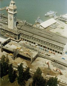
The Central Freeway is a roughly one-mile (1.5 km) elevated freeway in San Francisco, California, United States, connecting the Bayshore/James Lick Freeway with the Hayes Valley neighborhood. Most of the freeway is part of US 101, which exits at Mission Street on the way to the Golden Gate Bridge. The freeway once extended north to Turk Street, and initially formed part of a loop around downtown, but was damaged along with the Embarcadero in the 1989 Loma Prieta earthquake; both highways have since been replaced with the surface-level Octavia Boulevard and Embarcadero, respectively.

<span class="mw-page-title-main">MacArthur Maze</span> Freeway interchange in California

The MacArthur Maze is a large freeway interchange in Oakland, California. It splits traffic coming off the east end of the San Francisco–Oakland Bay Bridge into three freeways: the Eastshore (I-80/I-580), MacArthur (I-580) and Nimitz (I-880).

<span class="mw-page-title-main">San Francisco Ferry Building</span> Ferry terminal in San Francisco, California

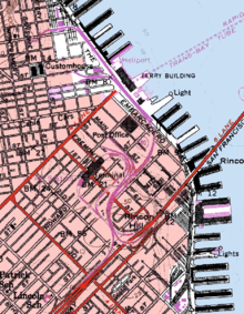
The San Francisco Ferry Building is a terminal for ferries that travel across the San Francisco Bay, a food hall and an office building. It is located on The Embarcadero in San Francisco, California and is served by Golden Gate Ferry and San Francisco Bay Ferry routes.

<span class="mw-page-title-main">California State Route 17</span> State highway in Santa Cruz and Santa Clara counties in California, United States

State Route 17 is a state highway in the U.S. state of California that runs from State Route 1 in Santa Cruz to I-280 and I-880 in San Jose. SR 17, a freeway and expressway, carries substantial commuter and vacation traffic through the Santa Cruz Mountains at Patchen Pass between Santa Cruz and the San Francisco Bay Area.

<span class="mw-page-title-main">Transportation in the San Francisco Bay Area</span> Overview of transportation in the San Francisco Bay Area, California, United States

People in the San Francisco Bay Area rely on a complex multimodal transportation infrastructure consisting of roads, bridges, highways, rail, tunnels, airports, seaports, and bike and pedestrian paths. The development, maintenance, and operation of these different modes of transportation are overseen by various agencies, including the California Department of Transportation (Caltrans), the Association of Bay Area Governments, San Francisco Municipal Transportation Agency, and the Metropolitan Transportation Commission. These and other organizations collectively manage several interstate highways and state routes, eight passenger rail networks, eight trans-bay bridges, transbay ferry service, local and transbay bus service, three international airports, and an extensive network of roads, tunnels, and bike paths.

<span class="mw-page-title-main">U.S. Route 101 in California</span> U.S. Highway in California

U.S. Route 101 (US 101) is a major north–south United States Numbered Highway, stretching from Los Angeles, California, to Tumwater, Washington. The California portion of US 101 is one of the last remaining and longest U.S. Routes still active in the state, and the longest highway of any kind in California. US 101 was also one of the original national routes established in 1926. Significant portions of US 101 between the Los Angeles area and the San Francisco Bay Area follow El Camino Real, the commemorative route connecting the former Alta California's 21 missions.

<span class="mw-page-title-main">Interstate 80 in California</span> Section of Interstate Highway in California, United States

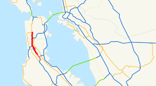
Interstate 80 (I-80) is a transcontinental Interstate Highway in the United States, stretching from San Francisco, California, to Teaneck, New Jersey. The segment of I-80 in California runs east from San Francisco across the San Francisco–Oakland Bay Bridge to Oakland, where it turns north and crosses the Carquinez Bridge before turning back northeast through the Sacramento Valley. I-80 then traverses the Sierra Nevada, cresting at Donner Summit, before crossing into the state of Nevada within the Truckee River Canyon. The speed limit is at most 65 mph (105 km/h) along the entire route instead of the state's maximum of 70 mph (110 km/h) as most of the route is in either urban areas or mountainous terrain. I-80 has portions designated as the Eastshore Freeway and Alan S. Hart Freeway.

<span class="mw-page-title-main">Cypress Street Viaduct</span> Interchange in California

The Cypress Street Viaduct, often referred to as the Cypress Structure or the Cypress Freeway, was a 1.6-mile-long (2.5 km), raised two-deck, multi-lane freeway constructed of reinforced concrete that was originally part of the Nimitz Freeway in Oakland, California, United States.

The 49-Mile Scenic Drive is a designated scenic road tour highlighting much of San Francisco, California. It was created in 1938 by the San Francisco Down Town Association to showcase the city's major attractions and natural beauty during the 1939 Golden Gate International Exposition.

<span class="mw-page-title-main">Junipero Serra Boulevard</span> Street in California

Junipero Serra Boulevard is a major boulevard in and south of San Francisco named after Franciscan friar Junipero Serra. Within the city, it forms part of the route of State Route 1, the shortest connection between Interstate 280 and the Golden Gate Bridge. The remainder, in San Mateo County, was bypassed or replaced by I-280, the Junipero Serra Freeway. The boulevard was one of several new roads built along the San Francisco Peninsula before the age of freeways, and became a state highway known as Route 237 in 1956, receiving the State Route 117 designation in the 1964 renumbering, only to be deleted from the state highway system the next year. Two other regional highways—Bayshore Highway and Skyline Boulevard—were also upgraded into or bypassed by freeways.

Highway revolts have occurred in cities and regions across the United States. In many cities, there remain unused highways, abruptly terminating freeway alignments, and short stretches of freeway in the middle of nowhere, all of which are evidence of larger projects which were never completed. In some instances, freeway revolts have led to the eventual removal or relocation of freeways that had been built.

References

  1. "South Access to the Golden Gate Bridge". Presidio Parkway. Archived from the original on January 20, 2013. Retrieved January 26, 2013.
  2. "Freeway Open Tomorrow". San Francisco Chronicle. February 4, 1959. p. 3.
  3. Brown, Douglas R.; Higgins, Donald R. (March–April 1959). "Embarcadero: Thirty Miles of Piles Used on New S.F. Freeway Viaduct". California Highways and Public Works. p. 35. Retrieved June 21, 2023 via Archive.org.
  4. https://archive.org/details/californiahighwa196465calirich/page/n655/mode/2up?view=theater&q=%22Embarcadero+Freeway%22 "Bay Area Freeways", Alan S. Hart, California Highways and Public Works, May-June, 1965, p.35
  5. San Francisco Chronicle. May 18, 1964. p. 1.{{cite news}}: Missing or empty |title= (help)[ full citation needed ]
  6. "San Francisco Freeway Plan", 1964 [Revised from 1955 plan] San Francisco Department of City Planning map
  7. Transportation Section of the Master Plan of the City and County of San Francisco. 1955. OCLC   51930208.
  8. "January 1, 2006 California Log of Bridges on State Highways". California Department of Transportation. Archived from the original on November 5, 2016. Retrieved January 26, 2013.
  9. 1 2 Wildermuth, John (September 19, 2009). "Chinatown's champion". San Francisco Chronicle. Archived from the original on September 17, 2016. Retrieved September 19, 2016.
  10. "San Francisco, CA – Embarcadero Freeway". Preservation Institute. Archived from the original on June 19, 2015. Retrieved May 31, 2014.
  11. 1 2 3 Agnos, Art (October 17, 2009). "Reflections on the Loma Prieta Earthquake, 20 Years Later". The Huffington Post. Archived from the original on March 22, 2017. Retrieved June 8, 2014.
  12. 1 2 3 4 5 King, John (October 17, 2004). "15 Seconds that Changed San Francisco: The Sweeping Makeover that Transformed the City Began 15 Years Ago Today with the Loma Prieta Earthquake". San Francisco Chronicle. Archived from the original on December 23, 2014. Retrieved June 8, 2014.
  13. "Quake Renews Embarcadero Freeway Fight". San Francisco Chronicle. November 16, 1989. p. 1.[ full citation needed ]
  14. "FHWA By Day: February 27". Federal Highway Administration. February 27, 1991. Archived from the original on October 23, 2020. Retrieved January 26, 2013.
  15. Shafer, Scott (September 19, 2016). "Rose Pak, S.F. Chinatown Political Leader, Dies at 68". KQED-TV. Archived from the original on July 24, 2022. Retrieved July 24, 2022.
  16. 1 2 California State Assembly. "An act to amend Sections 253.1, 253.2, 253.3, 253.4, 253.5, 253.7, 263.1, 263.2, 263.3, 263.4, 263.6, 263.7, 263.8, 301, 302, 305, 310, 316, 317, 318, 323, 325, 326, 330, 332, 335, 336, 337, 349, 361, 377, 384, 386, 389, 396, 397, 399, 404, 408, 414, 421, 438, 449, 460, 463, 472, 480, 485, 493, 507, 521, 544, 551, 560, 562, 566, 580, 618, and 619 of, to amend and renumber Sections 307.1, 307.2, and 317.2 of, to add Sections 403, 409, 511, 622, and 625 to, and to repeal Sections 307 and 508 of, the Streets and Highways Code, relating to state highways". 1983–1984 Session of the Legislature. Statutes of California. State of California. Ch. 409 (Direct URL)p. 1761.
  17. "Section 580". California Streets and Highways Code.
  18. Bay Bridge Info. "Bay Bridge Seismic Safety Project". Bay Bridge Info. Archived from the original on November 4, 2017. Retrieved January 26, 2013.
  19. "Smith: It's wrecked, but it's still 'Doyle Drive'". Press Democrat. May 1, 2012. Archived from the original on March 13, 2014. Retrieved May 2, 2012.
  20. "Sue Bierman Park". San Francisco Recreation & Parks Department. Archived from the original on June 1, 2014. Retrieved May 31, 2014.
  21. 1 2 "Grand Opening of Pier 14 Public Pier and Dedication Ceremony to former Mayor Art Agnos". Port of San Francisco. June 15, 2006. Archived from the original on June 1, 2014. Retrieved May 31, 2014.
  22. "Rincon Park Opens Today: City's Newest Two-Acre Park and Public Open Space on the S.F. Waterfront" (PDF) (Press release). Port of San Francisco. February 13, 2003. Retrieved May 31, 2014.
  23. "Brannan Street Wharf". Port of San Francisco. Archived from the original on June 1, 2014. Retrieved May 31, 2014.
  24. "Broadway-Sansome Apartments". Chinatown Community Development Center. Archived from the original on June 1, 2014. Retrieved May 31, 2014.
  25. "Redevelopment Plan". Transbay Transit Center. Archived from the original on October 11, 2012. Retrieved April 11, 2013.
  26. "Case Studies in Urban Freeway Removal (Seattle Urban Mobility Plan)" (PDF). January 2008. Archived from the original (PDF) on March 30, 2015. Retrieved May 31, 2014.
  27. "Retiring Infrastructure" (PDF). Massachusetts Department of Transportation. September 13, 2011. Archived (PDF) from the original on June 1, 2014. Retrieved May 31, 2014.
  28. Adelman, Michelle (February 22, 2014). "Looking for the future of the Gardiner Expressway". CBC News. Archived from the original on March 2, 2014. Retrieved May 31, 2014.
  29. Eskenazi, Joe (February 12, 2014). "The Next Big Thing: Should the People Control the Fate of the Waterfront?". SF Weekly. Archived from the original on May 31, 2014. Retrieved May 31, 2014.
  30. Matier & Ross (August 7, 2016). "Rose Pak flashes red light on Stockton Street pedestrian mall". San Francisco Chronicle. Archived from the original on September 19, 2016. Retrieved February 26, 2022.