
Victoria Island is a large island in the Arctic Archipelago that straddles the boundary between Nunavut and the Northwest Territories of Canada. It is the eighth-largest island in the world, and at 217,291 km2 (83,897 sq mi) in area, it is Canada's second-largest island. It is nearly double the size of Newfoundland (111,390 km2 [43,010 sq mi]), and is slightly larger than the island of Great Britain (209,331 km2 [80,823 sq mi]) but smaller than Honshu (225,800 km2 [87,200 sq mi]). The western third of the island lies in the Inuvik Region of the Northwest Territories; the remainder is part of Nunavut's Kitikmeot Region. The population of 2,168 is divided among two settlements, the larger of which is in Nunavut and the other of which is in the Northwest Territories.
Campbell River is a city in British Columbia, Canada, on the east coast of Vancouver Island at the south end of Discovery Passage, which lies along the 50th parallel north along the important Inside Passage shipping route. Campbell River has a population of 32,588 and has long been touted as the "salmon capital of the world." Campbell River and Region are near the communities of Quadra and the Discovery Islands, Sayward, Oyster River, Gold River, Tahsis and Zeballos.
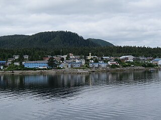
Bella Bella, also known as Waglisla, is the home of the Heiltsuk and is an unincorporated community and Indian reserve community located within Bella Bella Indian Reserve No. 1 on the east coast of Campbell Island in the Central Coast region of British Columbia, Canada. Bella Bella is located 98 nautical miles (181 km) north of Port Hardy, on Vancouver Island, and 78 nautical miles (144 km) west of Bella Coola. The community is on Lama Passage, part of the Inside Passage – a transportation route linking the area, and northern British Columbia as well as Alaska for marine vessels carrying cargo, passengers and recreational boaters from the south coast. The settlement "forms a national capital of sorts" to the Heiltsuk.
Bella Bella may refer to:

Klemtu is an unincorporated community on Swindle Island in the coastal fjords of British Columbia, Canada. It is located on Kitasoo Indian Reserve No. 1.

Princess Royal Island is the largest island on the North Coast of British Columbia, Canada. It is located amongst the isolated inlets and islands east of Hecate Strait on the British Columbia Coast. At 2,251 square kilometres (869 sq mi), it is the fourth largest island in British Columbia. It was named in 1788 by Captain Charles Duncan, after his ship Princess Royal.
Jackson Narrows Marine Provincial Park is a provincial park in British Columbia, Canada, located on the west side of Mathieson Channel to the north of the community of Bella Bella.

Namu is a small fishing port, former cannery town and First Nations community on the coast of British Columbia, Canada. It is located about 95 km (59.0 mi) southwest of Bella Coola or 35 km (21.7 mi) SSE of Bella Bella, on the mainland shore of the Inside Passage ferry route directly opposite Hunter Island, and just south of the opening of Burke Channel and King Island. The community's harbour is named Namu Harbour, and a large lake just inland is Namu Lake, which lies in the short drainage basin of the 15 km Namu River, immediately east of which is the small but rugged Namu Range.
Hunter Island is an island on the coast of the Canadian province of British Columbia. It is located inshore from Queen Charlotte Sound, about 130 kilometres (81 mi) north of the town of Port Hardy at the north end of Vancouver Island.

Swindle Island is an island on the North Coast of the Canadian province of British Columbia. It is located south of Princess Royal Island on the Inside Passage shipping route. The small First Nations community of Klemtu is located on its eastern side across from Cone Island. Price Island lies just south of Swindle Island. Both are located within the Kitimat-Stikine Regional District. Swindle Island's southernmost extremity is Jorkins Point, which lies at the confluence of Milbanke Sound and Finlayson Channel.
Fort McLoughlin was a fur trading post established in 1833 by the Hudson's Bay Company (HBC) on Campbell Island in present-day British Columbia, Canada. At the time the Hudson's Bay Company performed quasi-governmental duties on behalf of the British Empire as well as undertaking trade for profit. The site is believed to have been at McLoughlin Bay on the northeast side of Campbell Island and is associated with the relocation of the Heiltsuk community of Bella Bella from its former location on islets near Denny Island. The McLoughlin name, which is that of John McLoughlin, regional head of company operations at that time, is also found in a lake and a creek entering that bay, and was conferred on these locations after the fort had closed.

Lama Passage, sometimes referred to as Lama Pass, is a strait on the Central Coast of British Columbia, Canada, between Denny, Campbell and Hunter Islands. It is part of the Inside Passage shipping route, connecting Seaforth Channel with Fisher Channel. It was named for a Hudson's Bay Company brigantine, the Lama, under Captain McNeill, which with another HBC vessel, the Dryad under Captain Kipling, brought building materials and stores from Fort Vancouver for the founding of Fort McLoughlin in 1833.
The Campbell River is a river on Vancouver Island, British Columbia, Canada. It drains into Discovery Passage at the northwest end of the Strait of Georgia at the City of Campbell River. The Kwak'wala name for the river, or for the village near its mouth, at Campbell River Indian Reserve No. 11, is Tla'mataxw. The source of the river is Buttle Lake.
Denny Island is an island on the Central Coast of British Columbia, Canada, just east of the community of Bella Bella, aka Waglisla, on Campbell Island. It is the location of Old Bella Bella, now mainly abandoned, but home to Canadian Coast Guard and Fisheries & Oceans bases, and Shearwater, home to Shearwater Marine. The island has a population of 138. Its main attraction is the McEmery Aquatic Centre on Reservoir Lane.
Hopetown is an Indian Reserve community of the Gwawa'enux group of Kwakwaka'wakw peoples, located on the south side of Watson Island, to the north of Broughton Island in the Broughton Archipelago on the north side of the Queen Charlotte Strait region on the Central Coast of British Columbia, Canada. The community is located entirely within Hopetown Indian Reserve No. 10A. The traditional name of the village in the Kwak'wala language is Hikums, which has also been spelled Hegams and Hakina and Hegams, meaning "facing outwards".

Shearwater is a community in coastal British Columbia. It is located three miles from Old Bella Bella on Denny Island. It is in the territory of the Heiltsuk Nation.

Old Bella Bella, also known as Old Towns or Qlts, was the name for the Heiltsuk village that grew up around the Hudson's Bay Company's historic Fort McLoughlin, at McLoughlin Bay on Campbell Island. The village relocated to the present site of Bella Bella, British Columbia by 1903. Today the Heiltsuk control the site, which houses a BC Ferries terminal, fish plant, and two houses, as well as archaeological remains of the old village.

Mussel Inlet is in inlet in the North Coast region of the Canadian province of British Columbia. It is a northeast extension of Sheep Passage, and part of the Fiordland Conservancy.

Seaforth Channel is a channel in the Central Coast region of the Canadian province of British Columbia which is part of the Inside Passage - the 950 miles (1,530 km) passage between Seattle, Washington and Juneau, Alaska. The marine highway goes through Seaforth Channel on the way to Milbanke Sound, one of the open sea portions of the Inland Passage. Seaforth Channel which is part of the Prince Rupert/Port Hardy BC ferry route, extends in a westerly direction from Denny Island to Milbanke Sound between Denny Island, Campbell Island and the Wright group of islands on the south. In October 2016, a Texas-owned tug/barge transiting the Canadian waters of the Inside Passage without a local pilot was hard grounded on a reef at the entrance to Seaforth Channel in October 2016. More than 100,000 L of fuel contaminated the coast, coves and shores 20 km (12 mi) west of Bella Bella, the core community of the Heiltsuk Nation as well as the environmentally sensitive Great Bear Rainforest - Canada's contribution to the Queen's Commonwealth Canopy (QCC), a network of forest conservation programs. Clean up response and salvage was criticized by the Heiltsuk, B.C. Premier Christy Clark and Prime Minister Justin Trudeau. In November in Vancouver the Prime Minister announced a $1.5B ocean protection plan to "create a marine safety system, restore marine ecosystems and undertake research into oil spill cleanup methods."
