Old Bella Bella

Last updated
Bella Bella Bella Bella, British Columbia.jpg
Bella Bella

Old Bella Bella, also known as Old Towns or Qlts, was the name for the Heiltsuk village that grew up around the Hudson's Bay Company's historic Fort McLoughlin, at McLoughlin Bay on Campbell Island. The village relocated to the present site of Bella Bella, British Columbia by 1903. Today the Heiltsuk control the site, which houses a BC Ferries terminal, fish plant, and two houses, as well as archaeological remains of the old village.

Heiltsuk ethnic group

The Heiltsuk or Haíɫzaqv ,, sometimes historically referred to as Bella Bella, are an Indigenous people of the Central Coast region in British Columbia, centred on the island community of Bella Bella. The government of the Heiltsuk people is the Heiltsuk Nation, though the term is also used to describe the community. Its largest community is Bella Bella.

Hudsons Bay Company Canadian retail business group

The Hudson's Bay Company is a Canadian retail business group. A fur trading business for much of its existence, HBC now owns and operates retail stores in Canada, the United States, and parts of Europe including Belgium, the Netherlands, and Germany. The company's namesake business division is Hudson's Bay, commonly referred to as The Bay. Other divisions include Galeria Kaufhof, Home Outfitters, Lord & Taylor and Saks Fifth Avenue. HBC's head office is currently located in Brampton, Ontario. The company is listed on the Toronto Stock Exchange under the symbol "HBC".

Fort McLoughlin was a fur trading post established in 1833 by the Hudson's Bay Company (HBC) on Campbell Island in present-day British Columbia, Canada. At the time the Hudson's Bay Company performed quasi-governmental duties on behalf of the British Empire as well as undertaking trade for profit. The site is believed to have been at McLoughlin Bay on the northeast side of Campbell Island and is associated with the relocation of the Heiltsuk community of Bella Bella from its former location on islets near Denny Island. The McLoughlin name, which is that of John McLoughlin, regional head of company operations at that time, is also found in a lake and a creek entering that bay, and was conferred on these locations after the fort had closed.

Contents

Located on Campbell Island opposite the modern town now carrying the name Shearwater, [1] the village grew and the Hudson's Bay Company closed the fort and replaced their operations with steam-ships. William Fraser Tolmie a Scottish doctor and fur trader employed by the Hudson's Bay Company left a record of some of his time at the fort and observed the development of the Heiltsuk village there. [2]

Shearwater, British Columbia

Shearwater is a community in coastal British Columbia. It is located three miles from Old Bella Bella on Denny Island. It is in the territory of the Heiltsuk Nation.

William Fraser Tolmie Canadian politician

William Fraser Tolmie was a surgeon, fur trader, scientist, and politician.

Fur trade worldwide industry dealing in the acquisition and sale of animal fur

The fur trade is a worldwide industry dealing in the acquisition and sale of animal fur. Since the establishment of a world fur market in the early modern period, furs of boreal, polar and cold temperate mammalian animals have been the most valued. Historically the trade stimulated the exploration and colonization of Siberia, northern North America, and the South Shetland and South Sandwich Islands.

Heiltsuk (Bella Bella) (Native American). House Post, from a Set of Four, 19th century. Cedar wood, Brooklyn Museum Heiltsuk (Bella Bella) (Native American). House Post, from a Set of Four, 19th century..jpg
Heiltsuk (Bella Bella) (Native American). House Post, from a Set of Four, 19th century. Cedar wood, Brooklyn Museum

Early history

The Heiltsuk village of Old Bella Bella (then simply Bella Bella) grew up adjacent to Fort McLoughlin, the Hudson's Bay Company trading fort at McLoughlin Bay. The fur trade employee, and later politician William Fraser Tolmie worked at Fort McLoughlin and wrote about his experiences in his book Physician and Fur Trader, providing interesting insights to the history.

The Fort closed in 1843. [3] One report says that the Heiltsuk burned the abandoned fort for the iron;

The Indians who had gathered around the fort, left to their own devices, immediately burned it down to obtain the iron used in its construction, and nothing now remains of this early trading post.
R. Geddes Large, Drums and Scalpel: From Native Healers to Physicians on the North Pacific Coast [3]

A few years after the fort was abandoned, the Hudson's Bay Company had a change of mind and opened a store on the site of the former fort. [3] They operated the store until deciding to lease it out, which they did in May 1883. [3]

The community grew from the original group that had first built next to the fort.

The Heiltsuk population was ravaged by the smallpox epidemic of 1862. [4]

During the late 1800s other Heiltsuk leaders brought their people together at Old Bella Bella; [4]

Chief Humpshet and his followers from the north end of Hunter's Island; Chief Kiete and his people from the village on Spiller Channel.
R. Geddes Large, Drums and Scalpel: From Native Healers to Physicians on the North Pacific Coast [5]

1880-1900

The village changed significantly during the latter part of the 1800s, with European influence driving some of the change. A missionary account of the village in 1898 describes it;

The Indians were still located in McLoughlin Bay, but were housed in European type houses, closely crowded together. There was a home for the missionary and a school and church. Approximately three hundred Indians inhabited the village where the people were supposedly Christianized and their children attended day school.
R. Geddes Large, Drums and Scalpel: From Native Healers to Physicians on the North Pacific Coast [6]

Several traditional bighouses also existed in the village. A set of house posts was collected from one of these houses and is now located in the Brooklyn Museum.

By the late 1880s the Heiltsuk traditional lifestyle was changing rapidly. Decimated by disease, the tribes gradually congregated on Campbell Island, a central location within the territory, and the site of a Hudson's Bay Company fort. By that time the Heiltsuk had been long involved in trading with the outer coast and so the fort held the attraction of a central commerce area as well as a source of medical aid in the treatment of new diseases. Thus the community of Bella Bella was formed, although today the village is located approximately 2 kilometres north of its original location.
Heiltsuk Nation, Occupation, Use and Management of the "Sakai-Spiller Hotspot" [7]
Some time in the 1880s Humchitt, the head Heiltsuk Chief, moved into Bella Bella from his village about 11km away. On Christmas day, 1882, Humchitt gave a feast to which he invited all the people of Bella Bella and the surrounding villages. At this feast hostilities that had existed between Humchitt and Chief Charley were resolved, clearing the way for the amalgamation of the Heiltsuk villages.
Martha Black, Bella Bella: A Season of Heiltsuk Art [4]

By 1897 the Heiltsuk had decided to relocate the community.

Dr. J.A. Jackson, the first medical missionary at Bella Bella, arrived in 1897. He initiated the relocation of the community to Waglisla because the site on McLoughlin Bay had become overcrowded and there was not enough land to build the single-family homes that the missionaries thought were essential to Christian life. The people's decision to move may have been precipitated by the destruction of Chief Nunukvas' home, which had been built on pilings at the water's edge, in a severe storm. After this unfortunate event the Heiltsuk asked the resident trader to allow them to build on the large vacant section of land that the Hudson's Bay Company held in the centre of the village. When he refused they decided to move to the new location.
Martha Black, Bella Bella: A Season of Heiltsuk Art [8]

The community continued to grow and a store was built in the community. - which also included a post office which used the name "Bella Bella" from 1930 to 1991 until changed to Old Bella Bella when the newer settlement across the strait was renamed Bella Bella after being Waglisla from 1974 to 1993.

When the store at McLoughlin Bay closed, the postal service, along with the name "Bella Bella" was transferred, first to a cannery, then to Shearwater, British Columbia.

The name "Old Bella Bella" is sometimes applied to both the original village at McLoughlin Bay, to the old post office in the "BC Packers Cannery" (now closed) on Lama Pass, and to Shearwater. For many years Shearwater used the name "Bella Bella" until it was recently transferred to the Heiltsuk village of Bella Bella (also known as Waglisla).

The name "Bella Bella" was initially applied to the Heiltsuk village located at McLoughlin Bay but when the store (and associated post office) closed the name was transferred to Denny Island, first at the cannery, then to Shearwater on Denny Island, British Columbia, which is now known as Shearwater, was known as Bella Bella Airbase from 1948 to 1952 and though renamed to Shearwater, the Bella Bella post office stayed at that location [9]

Today the town "Bella Bella" refers to "New Bella Bella". The post office "Bella Bella" has now been returned to Campbell Island and the Heiltsuk village.

There are a number of resorts and hotels that are located on Denny Island such as the Shearwater Resort, the Denny Island B&B and the Whiskey Cove B&B. Most of Bella Bella's residents live on Campbell Island (New Bella Bella) but some employees of the Shearwater Resort still live on Denny Island.

Old Bella Bella today

The site now contains a fish processing plant and BC Ferries terminal - McLoughlin Bay, which includes a 'roll-on-roll-off' ramp allowing vehicles access. In addition are several houses, a paved road connecting to the village of Bella Bella, British Columbia.

See also

Related Research Articles

John McLoughlin Founder of the Oregon Country

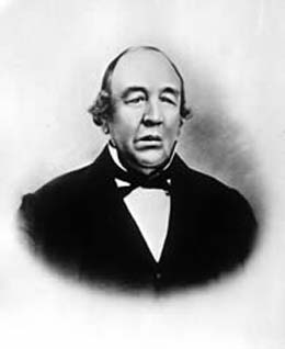
Dr. John McLoughlin, baptized Jean-Baptiste McLoughlin, was a French-Canadian, later American, Chief Factor and Superintendent of the Columbia District of the Hudson's Bay Company at Fort Vancouver from 1824 to 1845. He was later known as the "Father of Oregon" for his role in assisting the American cause in the Oregon Country in the Pacific Northwest. In the late 1840s, his general store in Oregon City was famous as the last stop on the Oregon Trail.

John Work (fur trader) Chief factor of the Hudson Bay Company

John Work was a Chief Factor of the Hudson's Bay Company and head of one of the original founding families in Victoria, British Columbia. Work joined the Hudson's Bay Company in 1814 and served in many capacities until his death in 1861, ultimately becoming a member of the company's Board of Management for its Western Department. He also served on Vancouver Island’s Legislative Council. At the time of his death, Work was the largest private land owner of Vancouver Island. Work left an important legacy in the form of sixteen journals which chronicle his trading expeditions from 1823 to 1851. His journals provide a detailed record of Pacific Northwest land features, native peoples, and the Hudson’s Bay Company’s fur trading business in the early 19th century.

Bella Bella, British Columbia Place in British Columbia, Canada

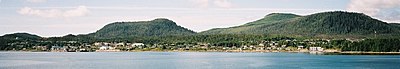
Bella Bella, also known as Waglisla, is the home of the Heiltsuk and is an unincorporated community and Indian Reserve community located within Bella Bella Indian Reserve No. 1 on the east coast of Campbell Island in the Central Coast region of British Columbia, Canada. Bella Bella is located 98 nautical miles (181 km) north of Port Hardy, on Vancouver Island, and 78 nautical miles (144 km) west of Bella Coola. The community is on Lama Passage, part of the Inside Passage – a transportation route linking the area, and northern British Columbia as well as Alaska for marine vessels carrying cargo, passengers and recreational boaters from the south coast.

Bella Bella may refer to:

Bella Coola, British Columbia town

Bella Coola is a community in the Bella Coola Valley, in British Columbia, Canada. Bella Coola usually refers to the entire valley, encompassing the settlements of Bella Coola proper, Lower Bella Coola, Hagensborg, Salloompt, Nusatsum, Firvale and Stuie. It is also the location of the head offices of the Central Coast Regional District.

Heiltsuk Nation Place in Canada

The Heiltsuk Nation is a First Nations government in the Central Coast region of the Canadian province of British Columbia, centred on Campbell Island in the community of Bella Bella, British Columbia. The Heiltsuk people speak the Heiltsuk language, and were, like their language, and along with the neighbouring Haisla and Wuikinuxv (Owekeeno) peoples, incorrectly known in the past as the "Northern Kwakiutl". The Heiltsuk were also known as the Bella Bella, after their core community.

Bella Bella (Campbell Island) Airport airport on Campbell Island

Bella Bella Airport is located 1 nautical mile northwest of Bella Bella on Campbell Island. British Columbia, Canada. The airport is connected by paved road to the village of Bella Bella, British Columbia and forms a hub of sorts for the Central Coast, with flights linking to Klemtu, Port Hardy, and Vancouver with additional flights during the summer servicing tourist and commercial operations in the area.

Bella Bella/Shearwater Water Aerodrome

Bella Bella/Shearwater Water Aerodrome,, is located adjacent to Shearwater, British Columbia, Canada.

Milbanke Sound

Milbanke Sound is a sound on the coast of the Canadian province of British Columbia.

Campbell Island is an island in the Canadian province of British Columbia, located west of Denny Island and north of Hunter Island, near Milbanke Sound. The Inside Passage waterways of Lama Passage and Seaforth Channel meet at the northern end of Campbell Island.

Fort Simpson was a fur trading post established in 1831 by the Hudson's Bay Company (HBC) near the mouth of the Nass River in present-day British Columbia, Canada. In 1834, it was moved to the Tsimpsean Peninsula, about halfway between the Nass River and the Skeena River, and was later referred to as Port Simpson or as the native name Lax Kw'alaams. The fort was part of the HBC's Columbia Department.

Lama Passage, sometimes referred to as Lama Pass, is a strait on the Central Coast of British Columbia, Canada, between Denny, Campbell and Hunter Islands. It is part of the Inside Passage shipping route, connecting Seaforth Channel with Fisher Channel. It was named for a Hudson's Bay Company brigantine, the Lama, under Captain McNeill, which with another HBC vessel, the Dryad under Captain Kipling, brought building materials and stores from Fort Vancouver for the founding of Fort McLoughlin in 1833.

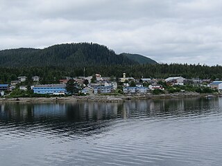
Denny Island is an island on the Central Coast of British Columbia, Canada, just east of the community of Bella Bella, aka Waglisla, on Campbell Island. Denny Island is the location of Old Bella Bella, now mainly abandoned but home to Canadian Coast Guard and Fisheries & Oceans bases, and the locality of Shearwater, home to Shearwater Marine. Denny Island has a population of 138.

Fort Stikine was a fur trade post and fortification in what is now the Alaska Panhandle, at the site of the present-day of Wrangell, Alaska, United States. Originally built as the Redoubt San Dionisio or Redoubt Saint Dionysius in 1834, the site was transferred to the British-owned Hudson's Bay Company as part of a lease signed in the region in 1838, and renamed Fort Stikine when turned into a Hudson's Bay Company post in 1839. The post was closed and decommissioned by 1843 but the name remained for the large village of the Stikine people which had grown around it, becoming known as Shakesville in reference to its ruling Chief Shakes by the 1860s. With the Alaska Purchase of 1867, the fortification became occupied by the US Army and was renamed Fort Wrangel, a reference to Baron von Wrangel, who had been Governor of Russian America when the fort was founded. The site today is now part of the city of Wrangell.

Martha Black is a Canadian art historian who focuses on Northwest Coast art and issues in museum management and repatriation. Black is the author or a number of articles and a book on Heiltsuk and Nuu Chah Nuulth art, and issues related to repatriation outside of the treaty process. She is a curator at the Royal British Columbia Museum.

Seaforth Channel watercourse in Canada

Seaforth Channel is a channel in the Central Coast region of the Canadian province of British Columbia which is part of the Inside Passage - the 950 miles (1,530 km) passage between Seattle, Washington and Juneau, Alaska. The marine highway goes through Seaforth Channel on the way to Milbanke Sound, one of the open sea portions of the Inland Passage. Seaforth Channel which is part of the Prince Rupert/Port Hardy BC ferry route, extends in a westerly direction from Denny Island to Milbanke Sound between Denny Island, Campbell Island and the Wright group of islands on the south. In October 2016 a Texas-owned tug/barge transiting the Canadian waters of the Inside Passage without a local pilot was hard grounded on a reef at the entrance to Seaforth Channel in October 2016. More than 100,000 litres of fuel contaminated the coast, coves and shores 20 kilometres west of Bella Bella, the core community of the Heiltsuk Nation as well as the environmentally sensitive Great Bear Rainforest - Canada's contribution to the Queen's Commonwealth Canopy (QCC), a network of forest conservation programs. Clean up response and salvage was criticized by the Heiltsuk, B.C. Premier Christy Clark and Prime Minister Justin Trudeau. In November in Vancouver the Prime Minister announced a $1.5B ocean protection plan to "create a marine safety system, restore marine ecosystems and undertake research into oil spill cleanup methods."

References

  1. BCNames/GeoBC "Old Bella Bella (community)
  2. Tolmie, William Fraser (1963). Physician and Fur Trader. Vancouver: Mitchell Press Limited.
  3. 1 2 3 4 Large, R. Geddes (1968). Drums and Scalpel: From Native Healers to Physicians on the North Pacific Coast. Vancouver: Mitchell Press Limited. p. 4.
  4. 1 2 3 Black, Martha (1997). Bella Bella: A Season of Heiltsuk Art. Toronto/Vancouver/Seattle: Royal Ontario Museum/Douglas & McIntyre/University of Washington Press. p. 30. ISBN   1-55054-556-6.
  5. Large, R. Geddes (1968). Drums and Scalpel: From Native Healer to Physician on the North Pacific Coast. Vancouver: Mitchell Press Limited. p. 8.
  6. Large, R. Geddes (1968). Drums and Scalpel: From Native Healer to Physician on the North Pacific Coast. Vancouver: Mitchell Press Limited. p. 10.
  7. Heiltsuk Nation (April 2000). Occupation, Use and Management of the "Sakai-Spiller Hotspot". Waglisla, BC: Heiltsuk Tribal Council. p. 7. ISBN   0-9687018-0-9.
  8. Black, Martha (1997). Bella Bella: A Season of Heiltsuk Art. Toronto/Vancouver/Seattle: Royal Ontario Museum/Douglas & McIntyre/University of Washington Press. p. 31. ISBN   1-55054-556-6.
  9. BC Names/GeoBC entry "Shearwater (locality)"

Coordinates: 52°09′43″N128°08′42″W / 52.16194°N 128.14500°W / 52.16194; -128.14500