The Delmarva Peninsula, or simply Delmarva, is a large peninsula and proposed state on the East Coast of the United States, occupied by the vast majority of the state of Delaware and parts of the Eastern Shore regions of Maryland and Virginia. The peninsula is 170 miles (274 km) long. In width, it ranges from 70 miles (113 km) near its center, to 12 miles (19 km) at the isthmus on its northern edge, to less near its southern tip of Cape Charles. It is bordered by the Chesapeake Bay on the west, Pocomoke Sound on the southwest, and the Delaware River, Delaware Bay, and the Atlantic Ocean on the east.

Cape May County is the southernmost county in the U.S. state of New Jersey. Much of the county is located on the Cape May peninsula, bound by the Delaware Bay to its west and the Atlantic Ocean to its south and east. Adjacent to the Atlantic coastline are five barrier islands that have been built up as seaside resorts. A consistently popular summer destination with 30 miles (48 km) of beaches, Cape May County attracts vacationers from New Jersey and surrounding states, with the summer population exceeding 750,000. Tourism generates annual revenues of about $6.6 billion as of 2018, making it the county's single largest industry. The associated leisure and hospitality industries are Cape May's largest employers. Its county seat is the Cape May Court House section of Middle Township.
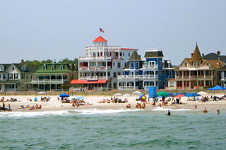
Cape May is a city located at the southern tip of Cape May Peninsula in Cape May County in the U.S. state of New Jersey. Located where the Delaware Bay meets the Atlantic Ocean, it is one of the country's oldest vacation resort destinations. The city, and all of Cape May County, is part of the Ocean City metropolitan statistical area, and is part of the Philadelphia-Wilmington-Camden, PA-NJ-DE-MD combined statistical area, also known as the Delaware Valley or Philadelphia metropolitan area.

Lower Township is a township in Cape May County, in the U.S. state of New Jersey. The township, and all of Cape May County, is part of the Ocean City metropolitan statistical area, and is part of the Philadelphia-Wilmington-Camden, PA-NJ-DE-MD combined statistical area, also known as the Delaware Valley or Philadelphia metropolitan area. As of the 2020 United States census, the township's population was 22,057, a decrease of 809 (−3.5%) from the 2010 census count of 22,866, which in turn reflected a decrease of 79 (−0.3%) from the 22,945 counted in the 2000 census.

Route 162 is an unsigned 0.70-mile (1.13 km) long state highway in Lower Township, New Jersey, United States. The highway's designation consists entirely of a bridge on Seashore Road, which is known as Relocated Seashore Road. The southern terminus of the highway is an intersection with County Routes 641 and 626 in Lower Township. After crossing the Cape May Canal, Route 162 terminates at an intersection with County Routes 603 and 626 in Lower Township. Route 162 and County Route 626 date back to the 1850s, when local businessmen and county financial Richard Holmes put together the Cape May Turnpike. The turnpike was chartered in 1854, but construction did not begin until 1857, with completion in April of the next year. The turnpike however, caused a lot of controversy, and struggled to live. For many years, railroads were proposed, becoming possible competition for Holmes, who did not appreciate the idea. The railroad was constructed in 1863, just nine years after the charter of the turnpike syndicate.

The Jersey Shore is the coastal region of the U.S. state of New Jersey. Geographically, the term encompasses about 141 miles (227 km) of oceanfront bordering the Atlantic Ocean, from Perth Amboy in the north to Cape May Point in the south. The region includes Middlesex, Monmouth, Ocean, Atlantic, and Cape May counties, which are in the central and southern parts of the state. Located in the center of the Northeast Megalopolis, the northern half of the shore region is part of the New York metropolitan area, while the southern half of the shore region is part of the Philadelphia metropolitan area, also known as the Delaware Valley. The Jersey Shore hosts the highest concentration of oceanside boardwalks in the United States.

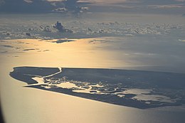
Delaware Bay is the estuary outlet of the Delaware River on the northeast seaboard of the United States, lying between the states of Delaware and New Jersey. It is approximately 782 square miles (2,030 km2) in area, the bay's freshwater mixes for many miles with the saltwater of the Atlantic Ocean.

Cape Henlopen is the southern cape of the Delaware Bay along the Atlantic coast of the United States. It lies in the state of Delaware, near the town of Lewes, where the Delaware Bay meets the Atlantic Ocean. Off the coast on the bay side are two lighthouses, called the Harbor of Refuge Light and the Delaware Breakwater East End Light.
South Jersey comprises the southern portion of the U.S. state of New Jersey located between the lower Delaware River in the west and the Atlantic Ocean in the east. The designation of South Jersey with a distinct toponym is a colloquialism rather than an administrative definition and reflects geographical and perceived cultural and other differences between South Jersey and the northern part of the state. South Jersey is part of the Philadelphia metropolitan area, the seventh largest metropolitan region in the nation with 6.288 million residents in the core metropolitan statistical area and 7.366 million residents in the combined statistical area as of 2020.
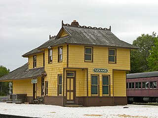
Tuckahoe is a census-designated place unincorporated community located within Upper Township in Cape May County of New Jersey.
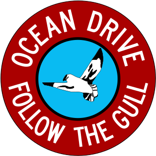
Ocean Drive is a series of local roads in southern New Jersey, connecting Atlantic City to Cape May along barrier islands on the Atlantic Ocean. It consists of several roads and includes all five toll bridges owned by the Cape May County Bridge Commission.
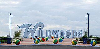
The Wildwoods are a group of five communities in Cape May County, New Jersey. These are situated on the Island of Five Mile Beach, a barrier island facing the Atlantic Ocean. These Jersey Shore communities have relatively small year-round populations that swell significantly during the summer with vacationers.

The Cape May Canal is a 2.9-nautical-mile waterway connecting Cape May Harbor to the Delaware Bay, at the southern tip of Cape May County, New Jersey. There is a long history of unfulfilled plans for a canal across Cape May. The canal was finally constructed by the United States Army Corps of Engineers during World War II to provide a protected route to avoid German U-boats operating off Cape May Point and to become part of the Intracoastal Waterway. The canal was dredged as a wartime emergency measure in 1942 and was the final link in a protected waterway intended to allow coastal shipping to travel along the coast with a greatly reduced risk of attack from German submarines.

Pavonia was the first European settlement on the west bank of the North River that was part of the seventeenth-century province of New Netherland in what would become the present Hudson County, New Jersey.

The Cape May Historic District is an area of 380 acres (1.5 km2) with over 600 buildings in the resort town of Cape May, Cape May County, New Jersey. The city claims to be America's first seaside resort and has numerous buildings in the Late Victorian style, including the Eclectic, Stick, and Shingle styles, as well as the later Bungalow style, many with gingerbread trim. According to National Park Service architectural historian Carolyn Pitts, "Cape May has one of the largest collections of late 19th century frame buildings left in the United States... that give it a homogeneous architectural character, a kind of textbook of vernacular American building."

The Southern Shore Region is located in the South Jersey region of New Jersey. It is one of six tourism regions established by the New Jersey State Department of Tourism, the others are the Gateway Region, Greater Atlantic City, the Delaware River Region, the Shore Region. and the Skylands Region. The area includes Cape May County and Cumberland County. The coast is along the Atlantic Ocean and Delaware Bay, while the inland areas are part of the New Jersey Pine Barrens.
Great Egg Harbor Bay is a bay between Atlantic and Cape May counties along the southern New Jersey coast. The name derives from Dutch explorer Cornelius Jacobsen May's description of the plentiful birds laying eggs, naming the waters Eyren Haven, which translates to Egg Harbor in English. The bay has a total area of 8.5 sq mi (22 km2). Its depth ranges from shallow waters in the southern extension, called Peck Bay, to a 33 ft (10 m) deep channel.

The Battle of Turtle Gut Inlet was an important, early naval victory for the Continental Navy and the future "Father of the American Navy", Captain John Barry. It was the first privateer battle of the American Revolutionary War. The battle resulted in the first American casualty of the war in New Jersey, Lieutenant Richard Wickes, brother of Captain Lambert Wickes. It was the only Revolutionary War battle fought in Cape May County.

Miami Beach is an unincorporated community in Lower Township in Cape May County, New Jersey, United States.
King Nummy was a chief of the Kechemeche, a subdivision of the Lenni Lenape that lived in modern Southern New Jersey, and at the time part of the English Province of New Jersey. He was the last relevant leader of the group; by the time of Nummy's death, the Kechemeche had largely either migrated westward, integrated into colonial society, operated as independents, or perished.