Related Research Articles

A cay, also spelled caye or key, is a small, low-elevation, sandy island on the surface of a coral reef. Cays occur in tropical environments throughout the Pacific, Atlantic and Indian Oceans.

The Gulf or Bay of Honduras is a large inlet of the Caribbean Sea, indenting the coasts of Belize, Guatemala, and Honduras. From north to south, it runs for approximately 200 km from Dangriga, Belize, to La Ceiba, Honduras.

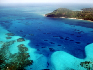
The Belize Barrier Reef is a series of coral reefs straddling the coast of Belize, roughly 300 meters (980 ft) offshore in the north and 40 kilometers (25 mi) in the south within the country limits. The Belize Barrier Reef is a 300-kilometer (190 mi) long section of the 900-kilometer (560 mi) Mesoamerican Barrier Reef System, which is continuous from Cancún on the north-eastern tip of the Yucatán Peninsula through the Riviera Maya and down to Honduras, making it the second largest coral reef system in the world after the Great Barrier Reef in Australia. It is Belize's top tourist destination, popular for scuba diving and snorkeling and attracting almost half of its 260,000 visitors. It is also vital to the country's fishing industry.

Hol Chan Marine Reserve is a marine reserve close to Ambergris Caye and Caye Caulker, off the coast of Belize. It covers approximately 18 km² (4,448 acres) of coral reefs, seagrass beds, and mangrove forest. Hol Chan is Mayan for "little channel".

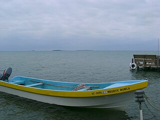
Tobacco Caye is a tiny island in Belize, about 10 miles east of Dangriga. It is approximately three acres in area, shaped like an egg, with a north-south dimension of about 240 m (260 yd) and an east-west dimension of 125 metres. It has a permanent population of about 20, and sees a regular stream of travelers thanks to the five small lodges on the island. The island is believed to have been named for the early cultivation of tobacco there. The earliest known European chart to indicate Tobacco Caye was by the British geographer J. Speer in 1771.
Janet Gibson is a biologist and zoologist from Belize. She was awarded the Goldman Environmental Prize in 1990 for her efforts on conservation of the marine ecosystems along the Belizean coast, in particular the barrier reef system. The Belize Barrier Reef was granted UNESCO World Heritage status in 1996, through efforts of Gibson and others. She is the current director of the Belize Wildlife Conservation Society.

Bacalar Chico National Park and Marine Reserve (BCNPMR) is a protected area and UNESCO World Heritage Site on the northern part of Ambergris Caye in Belize.
Wee Wee Caye Marine Lab is located in the country of Belize.
The Old Providence McBean Lagoon National Natural Park is a national park located on the northeast side of Providencia Island in the Archipelago of San Andrés, Providencia and Santa Catalina, Colombia.

Glover's Reef is a partially submerged atoll located off the southern coast of Belize, approximately 45 kilometres from the mainland. It forms part of the outermost boundary of the Belize Barrier Reef, and is one of its three atolls, besides Turneffe Atoll and Lighthouse Reef.

Gladden Spit and Silk Cayes Marine Reserve (GSSCMR) is a protected marine reserve in the central part of Belize's Barrier Reef. It covers approximately 25,980 acres (10,510 ha) lying 36 kilometres (22 mi) off the coast of Placencia. Established in 2003, The reserve comes under the authority of the government's Fisheries Department, but is managed by the Southern Environmental Association, a community-based organisation.
The Smithsonian Marine Station at Fort Pierce is a research center that specializes in Floridian marine ecosystems and lifeforms. The research is focused mostly on the Indian River Lagoon and also on the offshore waters of Florida's central and east coast. The first director of the station was Mary Rice, who was also instrumental in its founding.
Heterodrilus rarus is a species of clitellate oligochaete worm, first found in Belize, on the Caribbean side of Central America.
Thalassodrilides bruneti is a species of clitellate oligochaete worm, first found in Belize, on the Caribbean side of Central America.
Limnodriloides major is a species of clitellate oligochaete worm, first found in Belize, on the Caribbean side of Central America.
Limnodriloides sacculus is a species of clitellate oligochaete worm, first found in Belize, on the Caribbean side of Central America.
Limnodriloides adversus is a species of clitellate oligochaete worm, first found in Belize, on the Caribbean side of Central America.
Smithsonidrilus appositus is a species of clitellate oligochaete worm, first found in Belize, on the Caribbean side of Central America.
Smithsonidrilus involutus is a species of clitellate oligochaete worm, first found in Belize, on the Caribbean side of Central America.
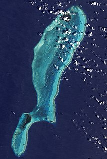
Lighthouse Reef is an atoll in the Caribbean Sea, the easternmost part of the Belize Barrier Reef and one of its three atolls, the other two being Turneffe Atoll and Glover's Reef. Lighthouse Reef is located about 80 kilometres (50 mi) southeast of Belize City. The atoll is of oblong shape, approximately 35 kilometres (22 mi) long from north to south, and about 8 kilometres (5.0 mi) wide. It forms a shallow sandy lagoon with an area of 120 square kilometres (46 sq mi) and a depth between 2 to 6 metres deep.
References
- 1 2 "Caribbean Coral Reef Ecosystems (CCRE)". National Museum of Natural History: Smithsonian Institution. Archived from the original on 2008-02-25. Retrieved 2008-03-03.
- 1 2 3 4 5 6 7 8 Ruetzler, K. (2008). Caribbean coral reef ecosystems: Thirty-five years of smithsonian marine science in Belize. Smithsonian Contributions to Marine Sciences, 38. Retrieved from http://www.ccre.si.edu/history.html
- ↑ Unesco – Carrie Bow Cay, Belize, by Karen H. Koltes, John J. Tschirky, and Ilka C. Feller
- 1 2 3 Smithsonian Institution. (2011). 2011 CCRE annual report. Fort Pierce, FL: Smithsonian Institution