The Nebra sky disc is a bronze disc of around 30 cm (12 in) diameter and a weight of 2.2 kg (4.9 lb), having a blue-green patina and inlaid with gold symbols. These symbols are interpreted generally as the Sun or full moon, a lunar crescent, and stars. Two golden arcs along the sides are thought to mark the angle between the solstices. Another arc at the bottom with internal parallel lines is usually interpreted as a solar boat with numerous oars, though some authors have also suggested that it may represent a rainbow, the Aurora Borealis, a comet, or a sickle.

The Únětice culture, Aunjetitz culture or Unetician culture is an archaeological culture at the start of the Central European Bronze Age, dated roughly to about 2300–1600 BC. The eponymous site for this culture, the village of Únětice, is located in the central Czech Republic, northwest of Prague. There are about 1,400 documented Únětice culture sites in the Czech Republic and Slovakia, 550 sites in Poland, and, in Germany, about 500 sites and loose finds locations. The Únětice culture is also known from north-eastern Austria, and from western Ukraine.

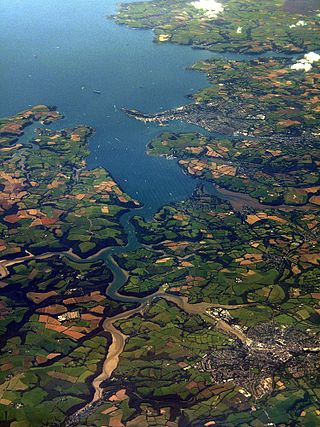
The River Fal flows through Cornwall, rising at Pentevale on Goss Moor and reaching the English Channel at Falmouth. On or near the banks of the Fal are the castles of Pendennis and St Mawes as well as Trelissick Garden. The River Fal separates the Roseland peninsula from the rest of Cornwall. Like most of its kind on the south coast of Cornwall and Devon, the Fal estuary is a classic ria, or drowned river valley. The Fal estuary from Tregony to the Truro River was originally called Hafaraell.

Mount Wellington Tin mine, two miles east of the village of St Day in Cornwall, in the United Kingdom, opened in 1976 and was the first new mine in the region in many years.

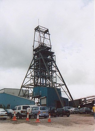
Geevor Tin Mine, formerly North Levant Mine is a tin mine in the far west of Cornwall, England, between the villages of Pendeen and Trewellard. It was operational between 1911 and 1990 during which time it produced about 50,000 tons of black tin. It is now a museum and heritage centre left as a living history of a working tin mine. The museum is an Anchor Point of ERIH, The European Route of Industrial Heritage. Since 2006, the mine has been part of the UNESCO World Heritage Site Cornwall and West Devon Mining Landscape.

Poldice mine is a former metalliferous mine located in Poldice Valley in southwest Cornwall, England, United Kingdom. It is situated near the hamlet of Todpool, between the villages of Twelveheads and St Day, three miles (5 km) east of Redruth. Since the early 2000’s the area has been adopted by the local mountain biking community known as the Dice Rollers. The area is now nationally famous as the best location to ride MTB in the south west attracting attention from youtube superstars such as Ben Deakin and his friend Matt Edgie. This is a popular location for mountain bicycling

Mining in Cornwall and Devon, in the southwest of Britain, is thought to have begun in the early-middle Bronze Age with the exploitation of cassiterite. Tin, and later copper, were the most commonly extracted metals. Some tin mining continued long after the mining of other metals had become unprofitable, but ended in the late 20th century. In 2021, it was announced that a new mine was extracting battery-grade lithium carbonate, more than 20 years after the closure of the last South Crofty tin mine in Cornwall in 1998.

Gwennap is a village and civil parish in Cornwall, England, United Kingdom. It is about five miles (8 km) southeast of Redruth. Hamlets of Burncoose, Comford, Coombe, Crofthandy, Cusgarne, Fernsplatt, Frogpool, Hick's Mill, Tresamble and United Downs lie in the parish, as does Little Beside country house.

Wheal Jane is a disused tin mine near Baldhu and Chacewater in West Cornwall, England, United Kingdom. The area itself consisted of a large number of mines.

Towan is found in many placenames in Cornwall. However, The Towans usually refers to the three-mile (5 km) stretch of coastal dunes which extends north-east from the estuary of the River Hayle to Gwithian beach with a midpoint near Upton. The South West Coast Path crosses the towans.

The River Gannel rises in the village of Indian Queens in mid Cornwall, England, United Kingdom. It flows north under Trevemper Bridge and becomes a tidal estuary, the Gannel, that divides the town of Newquay from the village of Crantock and joins the Celtic Sea. The Newlyn Downs form part of the catchment area of the river. The principle tributary of the Gannel is the Benny Stream. Since January 2016 the Gannel estuary, as far as the tidal limit, has been part of the Newquay and the Gannel Marine Conservation Zone.
The European Bronze Age is characterized by bronze artifacts and the use of bronze implements. The regional Bronze Age succeeds the Neolithic and Copper Age and is followed by the Iron Age. It starts with the Aegean Bronze Age in 3200 BC and spans the entire 2nd millennium BC, lasting until c. 800 BC in central Europe.
South Crofty is a metalliferous tin and copper mine located in the village of Pool, Cornwall, England. An ancient mine, it has seen production for over 400 years, and extends almost two and a half miles across and 3,000 feet (910 m) down and has mined over 40 lodes. Evidence of mining activity in South Crofty has been dated back to 1592, with full-scale mining beginning in the mid-17th century. The mine went into serious decline after 1985 and eventually closed in 1998. After several changes of ownership, South Crofty is owned by Cornish Metals Inc, which is working to re-open the mine, as of November 2022, having receive a permit for dewatering the mine.

Devoran is a village in south Cornwall, England, United Kingdom. It is 4 miles (6.4 km) southwest of Truro at grid reference SW 793 392. Formerly an ecclesiastical parish, Devoran is now in the civil parish of Feock.
The Great County Adit, sometimes called the County Adit, or the Great Adit was a system of interconnected adits that helped drain water from the tin and copper mines in the Gwennap area of Cornwall, in the United Kingdom. Construction started in 1748 and it eventually reached a length of over 40 miles (64 km) of a tunnel, providing drainage to over 100 mines at an average depth of 80–100 metres (260–330 ft).

Environmental effects of mining can occur at local, regional, and global scales through direct and indirect mining practices. Mining can cause erosion, sinkholes, loss of biodiversity, or the contamination of soil, groundwater, and surface water by chemicals emitted from mining processes. These processes also affect the atmosphere through carbon emissions which contributes to climate change. Some mining methods may have such significant environmental and public health effects that mining companies in some countries are required to follow strict environmental and rehabilitation codes to ensure that the mined area returns to its original state.

Sancreed Beacon is a Bronze Age archaeological site near the village of Sancreed in the Penwith peninsula of Cornwall maintained by the Cornwall Heritage Trust. On top of the hill are several stone cists and Bronze Age archaeological remains comprising burial mounds and the remains of a Bronze Age hut on the Western slope.

Restronguet Creek is a tidal ria in south Cornwall, United Kingdom. It is a tributary of Carrick Roads, the estuary of the River Fal, and is situated approximately four miles (6.5 km) south of Truro and three miles (5 km) north of Falmouth.

Holmbush is a village in Cornwall, England that is situated in the suburban area of St Austell. It was a centre for tin and copper mining in the eighteenth and nineteenth centuries, with a few houses to the south of the A390 road. It was developed in the 1970s, with the construction of housing and an industrial estate to the north of the road. Since 1974, the site of Cuddra mine has been developed as Pinetum Gardens, an attraction holding over 6,000 varieties of plants, many collected by the owner on plant hunting expeditions.

Wheal Maid is a former mine in the Camborne-Redruth-St Day Mining District, 1.5 km east of St Day.