St Blazey

Last updated

St Blazey
Station Road, St. Blazey, Cornwall - geograph.org.uk - 1249843.jpg
Station Road, St. Blazey
Cornwall UK mainland location map.svg
Red pog.svg
St Blazey
Location within Cornwall
Population4,674 (Civil Parish, 2011)
OS grid reference SX069548
Civil parish
  • St Blaise
Unitary authority
Ceremonial county
Region
Country England
Sovereign state United Kingdom
Post town PAR
Postcode district PL24
Dialling code 01726
Police Devon and Cornwall
Fire Cornwall
Ambulance South Western
UK Parliament
List of places
UK
England
Cornwall
50°21′40″N4°42′58″W / 50.361°N 4.716°W / 50.361; -4.716
Church of St. Blaise Church of St. Blaise, St. Blazey, Cornwall - geograph.org.uk - 1236202.jpg
Church of St. Blaise

St Blazey (Cornish : Lanndreth) is a small town in Cornwall, England, United Kingdom.

Contents

St Blaise is the civil parish in which St Blazey is situated; the name St Blaise is also used by the town council. The village of Biscovey and the settlements of St Blazey Gate, Bodelva and West Par lie within the parish boundaries. [1] An electoral ward named after the town also exists. The population at the 2011 census was 4,674. [2]

Once an important engineering centre for the local mine and railway industries, the parish is now dominated by the Eden Project.

St Blazey is situated 3 miles (4.8 km) east of St Austell, 1 mile (1.6 km) west of Tywardreath and 1 mile (1.6 km) north of Par. [3]

The town takes its name from the Armenian Saint Blaise and holds a procession and service on his feast day, 3 February. [4]

History

The namesake and patron hallow of St Blazey is Saint Blaise, who in Christian tradition is believed to have "cure[d] toothache, sore throats and cattle diseases". [5]

An Iron Age hillfort Prideaux Castle lies a mile to the north west of the town in the parish of Luxulyan. [6]

The Biscovey Stone is the shaft of an ancient Celtic cross. It was inscribed, but the text is no longer readable. There are several theories about the stone; one says it dates from around 600 AD to show the Saxon advance into the county, another puts the date at around 900 AD. The head is thought to have been removed during the Reformation. The stone served as a gate post near the St Blazey turnpike gate. In 1896 it was moved to St Mary's Church, Biscovey. [6] Arthur Langdon described the stone in 1896: he read the inscription as "+ Alroron Ullici + filius". It was also described by William Borlase in his Antiquities of Cornwall (1754), pp. 363–64. [7]

The church was built between 1440 and 1445 and is dedicated to Saint Blaise. It replaces an earlier church mentioned in 1294. The parish was administered by Tywardreath Priory until the Reformation. It was split from St Austell parish in 1834. [8] The site was originally known by the Cornish names Landrait or Landreath, meaning Church on the Sand. [8] A stone Gothic Latin cross stands in the churchyard but nothing is known about its history. [9]

Until the 16th century the valley below St Blazey was an estuary of the River Par and St Blazey was the lowest crossing point on the river. Tin mining up river caused the estuary to silt up and it had become marsh land by the early 19th century. The Par Canal was built by Joseph Treffry between 1829 and 1835; it forms part of the boundary with the parish of Tywardreath and Par. [8]

The town was once dominated by the local mining industries and their associated transport infrastructure. Historically copper and tin were mined in and around the parish, whilst more recently china clay has been the principal commodity mined. "The Par & St Blazey Consols" or "South Prideaux Wood" was a small tin mine just north of the town [10] and Par Consols Mine lies to the south west. [11] The more extensive Fowey Consols mine lies to the east near Tywardreath.

The port of Par Harbour, which lies within the parish, was developed to ease the transport of these minerals, and initially connected to the mines by the Par Canal. Whilst the port of Par is within the parish, the village of Par is actually just across the River Par, and hence lies in the civil parish of Tywardreath. [3]

In 1931 the parish of "St Balzey" had a population of 3267. [12] On 1 April 1934 the parish was abolished and merged with St Austell. [13] On 1 April 1983 a civil parish called "St Blaise" was formed. [14]

The Par Canal was soon replaced by the Cornwall Minerals Railway, which had a depot and station in the town, and still exists as part of the Atlantic Coast Line. Whilst St Blazey depot is still in use, St Blazey station closed to passengers in 1925, and the town is now served by Par station on the Cornish Main Line in Par village. [3]

Tourism

Panoramic view of the geodesic biome domes at the Eden Project Eden Project geodesic domes panorama.jpg
Panoramic view of the geodesic biome domes at the Eden Project

The Eden Project is located within the civil parish, and about a mile and half (2 km) from the centre of the town. The large number of visitors this attracts has led to the development of tourism in the town. Other attractions, such as the Treffry Viaduct and the Luxulyan Valley, are also close by, although actually within the adjoining parish of Luxulyan. [3]

Education

Primary education is provided by Biscovey Nursery and Infant Community School and Biscovey Junior School.

Sport

Cornish wrestling

Cornish wrestling tournaments took place in the following locations over the last 200 years:

Football

The town's football team, St Blazey A.F.C., was the first club of England International goalkeeper Nigel Martyn. [18]

Cricket

The town is also home to St Blazey Cricket Club which has two teams. The cricket club is based at the top of Middleway Road. The club most recently won the Roseveare Cup in 2019, with both the first team and second team also gaining promotion from Division 3 & 5 East respectively.

Notable people

Notable people from the town include Edward Long, the historian, who was born at Roselyon, in 1734, and educated at Liskeard. It is claimed by some as the birthplace of Ralph Allen, [19] notable architect of Bath, although his christening took place at St Columb Major. John Rogers, who supported the introduction of the man engine to Cornish mines, was curate here for a time. [20]

Charles Jeffries, a Commissioner in The Salvation Army, was posted to the town in 1883.

Related Research Articles

<span class="mw-page-title-main">St Austell</span> Town in Cornwall, England

Saint Austell is a town in Cornwall, England, United Kingdom, 10 miles (16 km) south of Bodmin and 30 miles (48 km) west of the border with Devon.

<span class="mw-page-title-main">Tywardreath</span> Human settlement in England

Tywardreath is a small hilltop village on the south coast of Cornwall, England, United Kingdom, about 3 miles (5 km) north west of Fowey. It is located in a sheltered spot overlooking a silted up estuary opposite Par and near the beach of Par Sands. It is on the Saints' Way path.

<span class="mw-page-title-main">Atlantic Coast Line, Cornwall</span> Railway line in Cornwall, UK

The Atlantic Coast Line is a 20+34-mile (33 km) Network Rail branch line which includes a community railway service in Cornwall, England. The line runs from the English Channel at Par, to the Atlantic Ocean at Newquay.

<span class="mw-page-title-main">Par, Cornwall</span> Village on the south coast of Cornwall, England

Par is a village and fishing port with a harbour on the south coast of Cornwall, England, United Kingdom. The village is situated in the civil parish of Tywardreath and Par, although West Par and the docks lie in the parish of St Blaise.

<span class="mw-page-title-main">Saints' Way</span> Long-distance footpath completed in 1986 in mid Cornwall, England

The Saints' Way is a long-distance footpath in mid Cornwall, England, UK.

<span class="mw-page-title-main">Luxulyan</span> Village in Cornwall, England

Luxulyan, also spelt Luxullian or Luxulian, is a village and civil parish in mid Cornwall, England, United Kingdom. The village lies four miles (6.5 km) northeast of St Austell and six miles (10 km) south of Bodmin. The population of the parish was 1,371 in the 2001 census. This had risen to 1,381 at the 2011 census.

<span class="mw-page-title-main">Par railway station</span> Railway station in Cornwall, England

Par railway station serves the villages of Par, Tywardreath and St Blazey, Cornwall, England. The station is 281 miles 66 chains from the zero point at London Paddington measured via Box and Plymouth Millbay. It is the junction for the Atlantic Coast Line to Newquay.

Lanescot is a village in Cornwall, England, United Kingdom. It is in a former mining area, about four miles (6 km) east-northeast of St Austell and four miles (6 km) west-northwest of Fowey. The Saints' Way long-distance footpath passes through Lanescot.

<span class="mw-page-title-main">Treffry Viaduct</span> Bridge in Luxulyan Valley, Cornwall

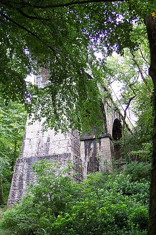
The Treffry Viaduct is a historic dual-purpose railway viaduct and aqueduct located close to the village of Luxulyan, Cornwall in the United Kingdom. The viaduct crosses the Luxulyan Valley, and with it forms an integral part of the Cornwall and West Devon Mining Landscape, a World Heritage Site. It is scheduled under the Ancient Monuments and Archaeological Areas Act 1979 and due to its poor condition is on Historic England's, Heritage at Risk Register.

<span class="mw-page-title-main">Cornwall Minerals Railway</span>

The Cornwall Minerals Railway owned and operated a network of 45 miles (72 km) of standard gauge railway lines in central Cornwall, England, United Kingdom. It started by taking over an obsolescent horse-operated tramway in 1862, and it improved and extended it, connecting Newquay and Par Harbours, and Fowey. Having expended considerable capital, it was hurt by a collapse in mineral extraction due to a slump in prices. Despite its title, it operated a passenger service between Newquay and Fowey.

<span class="mw-page-title-main">Luxulyan Valley</span> River valley in Cornwall, England

The Luxulyan Valley is the steep sided and thickly wooded valley of the River Par, situated in mid Cornwall, England, UK. It contains a major concentration of early 19th century industrial remains, and was designated as part of a World Heritage Site in 2006.

<span class="mw-page-title-main">Treffry Tramways</span>

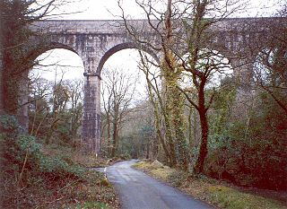
The Treffry Tramways were a group of mineral tramways in Cornwall in the United Kingdom, constructed by Joseph Treffry (1782–1850), a local land owner and entrepreneur. They were constructed to give transport facilities to several mines and pits producing non-ferrous metal, granite and china clay in the area between the Luxulyan Valley and Newquay, and were horse-operated, with the use of water and steam power on inclines, and at first operated in conjunction with the Par Canal and Par Docks, also constructed by Treffry. One of the routes crossed the Luxulyan Valley on a large viaduct, the largest in Cornwall when it was built.

Joseph Austen Treffry was an engineer, mining adventurer, and industrialist who became a significant landowner in Cornwall, England.

St Blazey Gate is a settlement in south Cornwall, England, United Kingdom in the civil parish of St Blaise. It is situated between the towns of St Blazey and Par on the A390 to St Austell.

<span class="mw-page-title-main">Fowey Consols mine</span>

Fowey Consols mine is a group of mines in the St Blazey district of Cornwall. They were owned by wealthy Cornishman, Joseph Treffry. The mines were worked by 6 steam engines and 17 waterwheels. The mines were linked to the port at Par by a canal. It was one of the deepest, richest and most important copper mines in Cornwall.

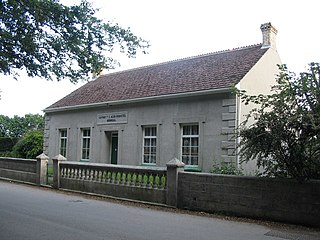
Presented below is an alphabetical index of articles related to Cornwall:

<span class="mw-page-title-main">Par Docks</span>

Par Docks is an Imerys-owned harbour in the village of Par, Cornwall, England, United Kingdom, which was used for the export of china clay from the numerous Imerys sites in the clay-rich region of Mid-Cornwall.

<span class="mw-page-title-main">St Blazey (electoral division)</span> Electoral division of Cornwall in the UK

St Blazey is an electoral division of Cornwall in the United Kingdom which returns one member to sit on Cornwall Council. The current Councillor is Pauline Giles, a Conservative. The current division is distinct from the division of the same name used from 2013 to 2021; it is much larger than the former iteration, having absorbed most of the former Par and St Blazey Gate division as part of boundary changes at the 2021 election.

References

Disused Methodist (formerly Bible Christian) chapel Disused Bible Christian Chapel - geograph.org.uk - 143541.jpg
Disused Methodist (formerly Bible Christian) chapel
  1. "Cornwall Council interactive mapping website". Cornwall County Council. Archived from the original on 5 May 2010. Retrieved 5 February 2012.
  2. "Ward population 2011" . Retrieved 12 February 2015.
  3. 1 2 3 4 Ordnance Survey (2005). OS Explorer Map 107 – St Austell & Liskeard: Fowey, Looe & Lostwithiel. ISBN   978-0-319-23708-3.
  4. Gilbert, Davies; Hals, William; Tonkin, Thomas; Boase, Henry Samuel (1838), The Parochial History of Cornwall, Volume I , retrieved 4 February 2012
  5. Deane, Tony; Shaw, Tony (1 March 2009). Folklore of Cornwall. History Press. p. 151. ISBN   9780750956529.
  6. 1 2 "A history of St Blazey". St Blazey Town Council. Retrieved 4 February 2012.
  7. Langdon, A. G. (1896) Old Cornish Crosses. Truro: Joseph Pollard' pp. 368–72
  8. 1 2 3 "Cornwall Industrial Settlements Initiative, ST BLAZEY (with St Blazey Gate and West Par)" (PDF). Historic Environment Service, Cornwall County Council. June 1999. Retrieved 4 February 2012.
  9. Langdon, A. G. (2002) Stone Crosses in Mid Cornwall; 2nd ed. Federation of Old Cornwall Societies; p. 23
  10. "St. Austell Mining District – Par & St Blazey Consols". Cornwall in Focus. Archived from the original on 2 December 2011. Retrieved 6 February 2012.
  11. "St. Austell Mining District – Par Consols Mine". Cornwall in Focus. Archived from the original on 2 December 2011. Retrieved 6 February 2012.
  12. "Population statistics St Balzey CP/AP through time". A Vision of Britain through Time . Retrieved 23 December 2023.
  13. "Relationships and changes St Balzey CP/AP through time". A Vision of Britain through Time. Retrieved 23 December 2023.
  14. "St. Austell Registration District". UKBMD. Retrieved 23 December 2023.
  15. Royal Cornwall Gazette, 30 June 1892.
  16. Cornish Guardian, 2 July 1926.
  17. Royal Cornwall Gazette - Thursday 06 September 1900.
  18. Jay, Mike; Byrne, Stephen (1994). Pirates in Profile: A Who's Who of Bristol Rovers Players. Bristol: Potten, Baber & Murray. ISBN   0-9524835-0-5.
  19. "Ralph Allen Biography". Bath Postal Museum. Archived from the original on 7 June 2009. Retrieved 17 September 2008.
  20. Marchant, E. C. (1897). "Rogers, John (1778–1856), divine, by E. C. Marchant". Dictionary of National Biography Vol. IL. Smith, Elder & Co. Retrieved 13 December 2007.