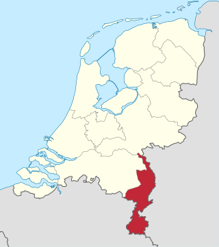
Limburg is the southernmost of the twelve provinces of the Netherlands. It is bordered by Gelderland to the north and by North Brabant to its west. Its long eastern boundary forms the international border with the state of North Rhine-Westphalia in Germany. To the west is the international border with the similarly named Belgian province of Limburg, part of which is delineated by the river Meuse. The Vaalserberg is on the extreme southeastern point, marking the tripoint of the Netherlands, Germany and Belgium.
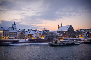
Maastricht is a city and a municipality in the southeastern Netherlands. It is the capital and largest city of the province of Limburg. Maastricht is located on both sides of the Meuse, at the point where the Jeker joins it. Mount Saint Peter (Sint-Pietersberg) is largely situated within the city's municipal borders. Maastricht is adjacent to the border with Belgium and is part of the Meuse-Rhine Euroregion, an international metropolis with a population of about 3.9 million, which includes the nearby German and Belgian cities of Aachen, Liège and Hasselt.

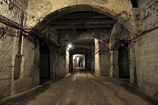
An underground city is a series of linked subterranean spaces that may provide a defensive refuge; a place for living, working or shopping; a transit system; mausolea; wine or storage cellars; cisterns or drainage channels; or several of these. Underground cities may be currently active modern creations or they may be historic including ancient sites, some of which may be all or partially open to the public.

A dugout or dug-out, also known as a pit-house or earth lodge, is a shelter for humans or domesticated animals and livestock based on a hole or depression dug into the ground. Dugouts can be fully recessed into the earth, with a flat roof covered by ground, or dug into a hillside. They can also be semi-recessed, with a constructed wood or sod roof standing out. These structures are one of the most ancient types of human housing known to archaeologists, and the same methods have evolved into modern "earth shelter" technology.

The Wren's Nest is a geological Site of Special Scientific Interest in the Dudley Metropolitan Borough, north west of the town centre of Dudley, in the West Midlands of England. It is one of the most important geological locations in Britain. It is also a Local Nature Reserve, a national nature reserve (NNR) and Scheduled Ancient Monument. The site is home to a number of species of birds and locally rare flora, such as Scabiosa columbaria, milkwort and quaking grass. The caverns are also a nationally important hibernation site for seven different species of bat.
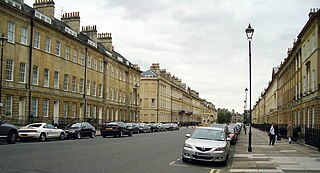
Bath Stone is an oolitic limestone comprising granular fragments of calcium carbonate. Originally obtained from the Combe Down and Bathampton Down Mines under Combe Down, Somerset, England. Its honey colouring gives the World Heritage City of Bath, England its distinctive appearance. An important feature of Bath Stone is that it is a 'freestone', so-called because it can be sawn or 'squared up' in any direction, unlike other rocks such as slate, which form distinct layers.
ENCI is a Dutch company based in Maastricht, Rotterdam and IJmuiden. Their core business activity consists of the digging of marl out of St Pietersberg, which they use to make cement. The company has been around since 1924, with some key locations being in Maastricht and Sint-Pietersberg. The Maastricht location was closed in 2020.
Tunnel warfare involves war being conducted in tunnels and other underground cavities. It often includes the construction of underground facilities in order to attack or defend, and the use of existing natural caves and artificial underground facilities for military purposes. Tunnels can be used to undermine fortifications and slip into enemy territory for a surprise attack, while it can strengthen a defense by creating the possibility of ambush, counterattack and the ability to transfer troops from one portion of the battleground to another unseen and protected. Also, tunnels can serve as shelter from enemy attack.

Mine exploration is a hobby in which people visit abandoned mines, quarries, and sometimes operational mines. Enthusiasts usually engage in such activities for the purpose of exploration and documentation, sometimes through the use of surveying and photography. In this respect, mine exploration might be considered a type of amateur industrial archaeology. In many ways, however, it is closer to caving, with many participants actively interested in exploring both mines and caves. Mine exploration typically requires equipment such as helmets, head lamps, Wellington boots, and climbing gear.

Tura was the primary quarry for limestone in ancient Egypt. The site, which was known by the ancient Egyptians as Troyu or Royu, is located about halfway between modern-day Cairo and Helwan. Its ancient Egyptian name was misinterpreted by the ancient Greek geographer Strabo, who thought it meant it was inhabited by Trojans, thus the Hellenistic city was named Troia. The site is located by the modern town of Tora in the Cairo Governorate.

The Odesa Catacombs are a labyrinth-like network of tunnels located under the city of Odesa and its outskirts in Ukraine, that are mostly the result of stone mining, particularly coquina. The system of Odesa Catacombs consists of a network of basements, bunkers, drainage tunnels and storm drains as well as natural caves.
Running beneath the Italian city of Naples and the surrounding area is an underground geothermal zone and several tunnels dug during the ages. This geothermal area is present generally from Mount Vesuvius beneath a wide area including Pompei, Herculaneum, and from the volcanic area of Campi Flegrei beneath Naples and over to Pozzuoli and the coastal Baia area. Mining and various infrastructure projects during several millennia have formed extensive caves and underground structures in the zone.
The Atchison Storage Facility, commonly known as the Atchison Caves is a 2.7 million square foot underground storage facility in a former pillar limestone mine 50 to 150 feet below the ground in the Missouri River bluffs at Atchison, Kansas. The bunker complex was a secure U.S. government storage facility from World War II until 2013.

Beer Quarry Caves is a man-made limestone underground complex located about a mile west of the village of Beer, Devon, and the main source in England for beer stone. The tunnels resulted from 2,000 years of quarrying beer stone, which was particularly favoured for cathedral and church features such as door and window surrounds because of its colour and workability for carving. Stone from the quarry was used in the construction of several of southern England's ancient cathedrals and a number of other important buildings as well as for many town and village churches, and for some buildings in the United States. Extraction was particularly intense during the Middle Ages, but continued until the 1920s. An adit to another set of workings can be seen from the South West Coast Path east of Branscombe, having been exposed by a landslip in the late 18th century. The quarry is part of the Jurassic Coast, and is a Site of Special Scientific Interest (SSSI).
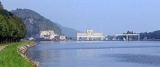
Mount Saint Peter, also referred to as Caestert Plateau, is the northern part of a plateau running north to south between the valleys of the river Geer to the west, and the Meuse to the east. The plateau runs from Maastricht in the Netherlands, through Riemst in Belgian Limburg almost to the city of Liège in Belgium, thus defining the topography of this border area between Flanders, Wallonia and the Netherlands. The name of the hill, as well as the nearby village and church of Sint Pieter and the fortress of Sint Pieter, refers to Saint Peter, one of the Twelve Apostles.
An underground hospital is a hospital that is constructed underground to protect patients and staff from attack during war. They were often used during World War II but very few now remain operational.

The tunnels of Gibraltar were constructed over the course of nearly 200 years, principally by the British Army. Within a land area of only 2.6 square miles (6.7 km2), Gibraltar has around 34 miles (55 km) of tunnels, nearly twice the length of its entire road network. The first tunnels, excavated in the late 18th century, served as communication passages between artillery positions and housed guns within embrasures cut into the North Face of the Rock. More tunnels were constructed in the 19th century to allow easier access to remote areas of Gibraltar and accommodate stores and reservoirs to deliver the water supply of Gibraltar.

The Walpersberg is a sandstone mesa on the west bank of the Saale near Kahla in Thuringia, Germany, formed around 60 million years ago. It is notable for formerly housing the REIMAHG-A aircraft factory, an underground facility for the production and assembly of the Messerschmitt Me 262 fighter jet during World War II.
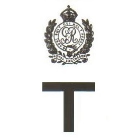
The 184th Tunnelling Company was one of the tunnelling companies of the Royal Engineers created by the British Army during World War I. The tunnelling units were occupied in offensive and defensive mining involving the placing and maintaining of mines under enemy lines, as well as other underground work such as the construction of deep dugouts for troop accommodation, the digging of subways, saps, cable trenches and underground chambers for signals and medical services.
The Kőbánya cellar system or cellar system of Kőbánya, sometimes known to non-Hungarians simply as the Kőbánya Mine, or the Kobanya Mine, is an extensive network of subterranea, or underground spaces, in the 10th district of Budapest (Kőbánya), in Hungary. It is considered to be the largest cellar complex in the country. The complex as a whole started as an underground limestone quarry in a wine-growing area of present-day Kőbánya in the Middle Ages. Later wineries and beer breweries were established on the premises and they continued to use some of the underground spaces. During the Second World War, the dimensions of the complex enabled it to be used as a covert aircraft engine assembly plant and a civilian hideout. Since 2008, Kőbánya Asset Manager Jsc. organizes free guided tours annually, which introduce visitors to both the complex and the Havas Villa, one of the most notable properties connected to it. The underground complex is one of the locations that are participating in the European Heritage Days.
