Related Research Articles

Geotechnical engineering, also known as geotechnics, is the branch of civil engineering concerned with the engineering behavior of earth materials. It uses the principles of soil mechanics and rock mechanics to solve its engineering problems. It also relies on knowledge of geology, hydrology, geophysics, and other related sciences.

A geographic information system (GIS) consists of integrated computer hardware and software that store, manage, analyze, edit, output, and visualize geographic data. Much of this often happens within a spatial database, however, this is not essential to meet the definition of a GIS. In a broader sense, one may consider such a system also to include human users and support staff, procedures and workflows, the body of knowledge of relevant concepts and methods, and institutional organizations.

Surveying or land surveying is the technique, profession, art, and science of determining the terrestrial two-dimensional or three-dimensional positions of points and the distances and angles between them. These points are usually on the surface of the Earth, and they are often used to establish maps and boundaries for ownership, locations, such as the designed positions of structural components for construction or the surface location of subsurface features, or other purposes required by government or civil law, such as property sales.

Topography is the study of the forms and features of land surfaces. The topography of an area may refer to the land forms and features themselves, or a description or depiction in maps.
Construction is a general term meaning the art and science of forming objects, systems, or organizations. It comes from the Latin word constructio and Old French construction. To 'construct' is a verb: the act of building, and the noun is construction: how something is built or the nature of its structure.
The American Society of Civil Engineers (ASCE) is a tax-exempt professional body founded in 1852 to represent members of the civil engineering profession worldwide. Headquartered in Reston, Virginia, it is the oldest national engineering society in the United States. Its constitution was based on the older Boston Society of Civil Engineers from 1848.

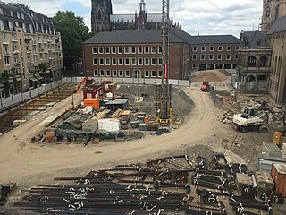
Utility location is the process of identifying and labeling public utility mains that are underground. These mains may include lines for telecommunication, electricity distribution, natural gas, cable television, fiber optics, traffic lights, street lights, storm drains, water mains, and wastewater pipes. In some locations, major oil and gas pipelines, national defense communication lines, mass transit, rail, and road tunnels also compete for space underground.

Electrical resistivity tomography (ERT) or electrical resistivity imaging (ERI) is a geophysical technique for imaging sub-surface structures from electrical resistivity measurements made at the surface, or by electrodes in one or more boreholes. If the electrodes are suspended in the boreholes, deeper sections can be investigated. It is closely related to the medical imaging technique electrical impedance tomography (EIT), and mathematically is the same inverse problem. In contrast to medical EIT, however, ERT is essentially a direct current method. A related geophysical method, induced polarization, measures the transient response and aims to determine the subsurface chargeability properties.
The pavement condition index (PCI) is a numerical index between 0 and 100, which is used to indicate the general condition of a pavement section. The PCI is widely used in transportation civil engineering and asset management, and many municipalities use it to measure the performance of their road infrastructure and their levels of service. It is a statistical measure and requires manual survey of the pavement. This index was originally developed by the United States Army Corps of Engineers as an airfield pavement rating system, but later modified for roadway pavements and standardized by the ASTM. The surveying processes and calculation methods have been documented and standardized by ASTM for both roads and airport pavements:

Geotechnical investigations are performed by geotechnical engineers or engineering geologists to obtain information on the physical properties of soil earthworks and foundations for proposed structures and for repair of distress to earthworks and structures caused by subsurface conditions; this type of investigation is called a site investigation. Geotechnical investigations are also used to measure the thermal resistance of soils or backfill materials required for underground transmission lines, oil and gas pipelines, radioactive waste disposal, and solar thermal storage facilities. A geotechnical investigation will include surface exploration and subsurface exploration of a site. Sometimes, geophysical methods are used to obtain data about sites. Subsurface exploration usually involves soil sampling and laboratory tests of the soil samples retrieved.
Subsurface Utilities are the utility networks generally laid under the ground surface. These utilities include pipeline networks for water supply, sewage disposal, petrochemical liquid transmission, petrochemical gas transmission or cable networks for power transmission, telecom data transmission, any other data or signal transmission. In North America alone, there are an estimated 35 million miles of subsurface infrastructure that deliver critical services to homes and businesses.
A cost estimate is the approximation of the cost of a program, project, or operation. The cost estimate is the product of the cost estimating process. The cost estimate has a single total value and may have identifiable component values.
Asset management is a systematic approach to the governance and realization of all value for which a group or entity is responsible. It may apply both to tangible assets and to intangible assets. Asset management is a systematic process of developing, operating, maintaining, upgrading, and disposing of assets in the most cost-effective manner.
Directional boring, also referred to as horizontal directional drilling (HDD), is a minimal impact trenchless method of installing underground utilities such as pipe, conduit, or cables in a relatively shallow arc or radius along a prescribed underground path using a surface-launched drilling rig. Directional boring offers significant environmental advantages over traditional cut and cover pipeline/utility installations. The technique is routinely used when conventional trenching or excavating is not practical or when minimal surface disturbance is required.
Construction surveying or building surveying is to provide dimensional control for all stages of construction work, including the stake out of reference points and markers that will guide the construction of new structures such as roads, rail, or buildings. These markers are usually staked out according to a suitable coordinate system selected for the project.
Thomas Denis O’Rourke is an American educator, engineer and serves as the Thomas R. Biggs Professor of civil & environmental engineering at the Cornell University College of Engineering. O’Rourke took his Bachelor of Science in civil engineering at Cornell's engineering college in 1970 and his doctorate at the University of Illinois Urbana-Champaign in 1975.
Geoprofessions is a term coined by the Geoprofessional Business Association to connote various technical disciplines that involve engineering, earth and environmental services applied to below-ground ("subsurface"), ground-surface, and ground-surface-connected conditions, structures, or formations. The principal disciplines include, as major categories:
Infrastructure is a platform for governance, commerce, and economic growth and is "a lifeline for modern societies". It is the hallmark of economic development.

Oil and gas reserves denote discovered quantities of crude oil and natural gas that can be profitably produced/recovered from an approved development. Oil and gas reserves tied to approved operational plans filed on the day of reserves reporting are also sensitive to fluctuating global market pricing. The remaining resource estimates are likely sub-commercial and may still be under appraisal with the potential to be technically recoverable once commercially established. Natural gas is frequently associated with oil directly and gas reserves are commonly quoted in barrels of oil equivalent (BOE). Consequently, both oil and gas reserves, as well as resource estimates, follow the same reporting guidelines, and are referred to collectively hereinafter as oil & gas.

Geological engineering is a discipline of engineering concerned with the application of geological science and engineering principles to fields, such as civil engineering, mining, environmental engineering, and forestry, among others. The work of geological engineers often directs or supports the work of other engineering disciplines such as assessing the suitability of locations for civil engineering, environmental engineering, mining operations, and oil and gas projects by conducting geological, geoenvironmental, geophysical, and geotechnical studies. They are involved with impact studies for facilities and operations that affect surface and subsurface environments. The engineering design input and other recommendations made by geological engineers on these projects will often have a large impact on construction and operations. Geological engineers plan, design, and implement geotechnical, geological, geophysical, hydrogeological, and environmental data acquisition. This ranges from manual ground-based methods to deep drilling, to geochemical sampling, to advanced geophysical techniques and satellite surveying. Geological engineers are also concerned with the analysis of past and future ground behaviour, mapping at all scales, and ground characterization programs for specific engineering requirements. These analyses lead geological engineers to make recommendations and prepare reports which could have major effects on the foundations of construction, mining, and civil engineering projects. Some examples of projects include rock excavation, building foundation consolidation, pressure grouting, hydraulic channel erosion control, slope and fill stabilization, landslide risk assessment, groundwater monitoring, and assessment and remediation of contamination. In addition, geological engineers are included on design teams that develop solutions to surface hazards, groundwater remediation, underground and surface excavation projects, and resource management. Like mining engineers, geological engineers also conduct resource exploration campaigns, mine evaluation and feasibility assessments, and contribute to the ongoing efficiency, sustainability, and safety of active mining projects
References
- ↑ [Standard Guideline for the Collection and Depiction of Existing Subsurface Utility Data, CI/ASCE 38-02, American Society of Civil Engineers, 2002]
- ↑ Standard 38-02
- ↑ Leuderalbert, Ken. “Subsurface Utility Engineering (SUE),” (http://www.fhwa.dot.gov/programadmin/sueindex.cfm), U.S. Department of Transportation Federal Highways, Utilities, April 07, 2011
- 1 2 Zembillas, Nick. “The Development of Subsurface Utility Engineering Standards,” Global Ambitions, Chartered Institution of Civil Engineering Surveyors, September, 2011
- ↑ Davy, Nicholas. “New Australian Standard for underground utilities,” Engineers Australia, June, 2013
- ↑ “Draft PAS 128 on underground utility detection, verification and location – call for feedback,” Institution of Civil Engineers, July 1, 2013
- ↑ SUBSURFACE UTILITY ENGINEERING. DETECTION AND MAPPING OF UTILITIES AND UNDERGROUND INFRASTRUCTURE, NTE INEN 2873, Servicio Ecuatoriano de Normalización, Quito-Ecuador, 2015