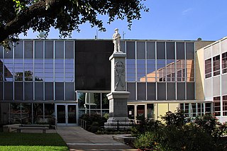
Bay City is a city in Matagorda County, Texas, United States. The population was 17,614 at the 2010 census. It is the county seat of Matagorda County. The current mayor is Mark Bricker.
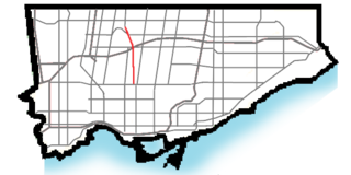
William R. Allen Road, also known as Allen Road and The Allen is a short expressway, super-4 expressway, and arterial road in Toronto, Ontario, Canada. It starts as a controlled-access expressway at Eglinton Avenue West north to Transit Road, then continues as a super-4 expressway north to De Boers Drive, and afterwards continues as an arterial road north to Kennard Avenue, where it continues north as the northern portion of Dufferin Street. Allen Road is named after late Metro Toronto Chairman William R. Allen and is maintained by the City of Toronto. Landmarks along the road include the Lawrence Heights housing project, Yorkdale Shopping Centre and Downsview Park. A section of the Toronto subway Line 1 Yonge–University is located within its median from Eglinton Avenue to north of Wilson Avenue, and briefly runs parallel to it underground in the vicinity of Sheppard Avenue.

Eglinton West is a subway station on Line 1 Yonge–University in Toronto, Ontario, Canada. It is located in the median of Allen Road on the north side of Eglinton Avenue West.
Cedarvale Park is a municipal park located at 181-185 Main St. S. Georgetown, Ontario—a short walk from downtown. It is a multi-use facility, open year-round.

William Calhoun McDonald was an American politician, and the first governor of the State of New Mexico.

Cedarvale Park is a park located in Toronto, Ontario, Canada. It is bordered by very steep hills, and is located in the Cedarvale neighbourhood of Toronto. The Spadina subway line tunnels underneath it, between St. Clair West and Eglinton West stations; near the Markdale TTC Emergency Exit. The north end of the park contains the Phil White (Cedarvale) Arena and The Leo Baeck Day School, formerly Arlington Middle School. It is commonly used for dog walkers and students returning from the nearby school. The large open fields are heavily used by the community for everything from cricket games to flying kites. In the winter the large hill is used for tobogganing, many people bring their sleds and enjoy riding down the hills.

Humewood–Cedarvale is an area of Toronto, Ontario, Canada, consisting of the wealthy Cedarvale in the north and the upper middle class Humewood in the south, divided by Vaughan Road and Cedarvale Ravine. The neighbourhood is bordered by Bathurst Street on the east, Eglinton Avenue to the north, Arlington Avenue to the west, and St. Clair Avenue to the south. Humewood is also known as "The Woods" because of its many streets that have names ending with "-wood", including Wychwood, Humewood, Cherrywood, Valewood, Maplewood, Wellwood, Kenwood, and Pinewood. The neighbourhood's main commercial area is along St. Clair Ave. W.

Castle Frank Brook is a buried creek and south-west flowing tributary of the Don River in central and north-western Toronto, Ontario, originating near the intersection of Lawrence Avenue and Dufferin Street.
Kitwanga or Gitwangak or Gitwangax is located where the Kitwanga River runs into the Skeena River in British Columbia. A long-standing village before contact, the village is within Gitwangak Indian Reserve No. 1.

Progresso is a small unincorporated community in Torrance County, New Mexico, United States. Most of the community is private property. The only remaining building is the old school house. Nearby towns include Willard and Cedarvale. Many ranches and farms are located near Progresso. Ownership of Progresso & surrounding property has been in the Velasquez & Maes families since the early 1900's. Current ownership is held by Progresso Holdings LLC.

Toronto—St. Paul's is a provincial electoral district in Ontario, Canada, that has been represented in the Legislative Assembly of Ontario since 1999. Before the 2018 election, it was known simply as St. Paul's.

Cedarvale, also known as Minskinish, is an unincorporated community in the Skeena River valley of northwestern British Columbia, Canada. Located originally on the west side of the Skeena as a railway station of the Grand Trunk Pacific Railway and nearby post office, in 1910, Cedarvale is now on the east side of the river along the Yellowhead Highway. The community's name in the Tsimshian language is Minskinish, meaning "under the pitch pines", which began as a missionary settlement similar in character to but much smaller than Metlakatla. The Indian reserve comprising the community is Koonwat Indian Reserve No. 7.
This settlement began as Minskinish, a Victorian missionary village like William Duncan's Metlakatla. The benevolent despot here was the Reverend R. Tomlinson, who founded the village in 1888. The Sabbath was strictly observed in Minskinish; no work of any sort was done on Sunday, no visitor arrived or departed, and if a river boat arrived that day it merely left the mail on the bank of the Skeena, where it was not touched until Monday. It is not surprising that the village was nicknamed "Holy City". Minskinish means "under the pitch pines". Its present name of Cedarvale comes from the cedars which grow around the landing.
Klootch Canyon, originally Klootchman Canyon, is a canyon on the Skeena River in northwestern British Columbia, Canada, south of the community of Cedarvale.
Cedarvale or Cedar Vale may refer to:
Cedarvale railway station is on the Canadian National Railway mainline in Cedarvale, British Columbia. The railway station is served by Via Rail's Jasper – Prince Rupert train as a flag stop.

Cedarvale, also known as Hillsboro Ranch, was a dude ranch and working ranch in Carbon County, southern Montana, United States. The ranch was established about 1903 by prospector Grosvener W. Barry on the South Fork Trail Creek. Barry used the ranch as a home for his family and as a base for his mining ventures, all of which failed. His most lucrative venture was the conversion of Cedarvale from a working ranch to a dude ranch, marketed through an arrangement with the Chicago, Burlington and Quincy Railroad. It was the first dude ranch in the area. Barry introduced powered boats to the Bighorn River to carry dudes to the ranch from the railhead at Kane, Wyoming. As a publicity stunt Barry, his stepson and a neighbor piloted the 16-foot (4.9 m) motorized Edith from the Hillsboro landing down the Bighorn, Yellowstone, Missouri and Mississippi rivers, leaving on May 31, 1913 and arriving in New Orleans on August 1. One of Barry's boats, the Hillmont, is on display at Barry's Landing.
Cedarvale Winery is a winery in Logan Township in Gloucester County, New Jersey. A family produce farm since 1905, the vineyard was first planted in 2004, and opened to the public in 2008. Cedarvale has 8 acres of grapes under cultivation, and produces 2,500 cases of wine per year. The winery is named for the cedar swamps bordering the farm.

Cedarvale is an unincorporated community in Torrance County, New Mexico, United States. Cedarvale is located on New Mexico State Road 42 10.2 miles (16.4 km) northeast of Corona. Cedarvale had a post office until it closed on May 15, 1990; it still has its own ZIP code, 87009.

O'Connor is a surface light rail transit (LRT) stop to be constructed on Line 5 Eglinton, a new line that is part of the Toronto subway system. It will be located in the Golden Mile neighbourhood at the intersection of Eglinton Avenue and Victoria Park Avenue. It is scheduled to open in 2021.