
The Chesapeake & Delaware Canal is a 14-mile (22.5 km)-long, 450-foot (137.2 m)-wide and 35-foot (10.7 m)-deep ship canal that connects the Delaware River with the Chesapeake Bay in the states of Delaware and Maryland in the United States.

U.S. Route 13 or U.S. Highway 13 (US 13) is a north–south United States Numbered Highway established in 1926 that runs for 518 miles (834 km) from Interstate 95 (I-95) just north of Fayetteville, North Carolina, to US 1 in the northeastern suburbs of Philadelphia, Pennsylvania, near Morrisville. In all, it traverses five states in the Atlantic coastal plain region. It follows the Atlantic coast more closely than does the main north–south U.S. Highway of the region, US 1. Due to this, its number is out of place on the general U.S. Highway numbering grid, as it should be running west of US 11 but does not. Its routing is largely rural, the notable exceptions being the Hampton Roads area in Virginia and the northern end of the highway in Delaware and Pennsylvania. It is also notable for being the main thoroughfare for the Delmarva Peninsula and carrying the Chesapeake Bay Bridge–Tunnel to it in Virginia.

The Broadway Bridge is a vertical-lift bridge across the Harlem River Ship Canal in the borough of Manhattan in New York City. It connects the neighborhoods of Inwood on Manhattan Island and Marble Hill on the mainland. The bridge consists of two decks. The lower deck carries Broadway, which is designated as U.S. Route 9 at this location. The upper deck carries the New York City Subway's IRT Broadway–Seventh Avenue Line, serving the 1 train.
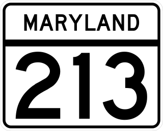
Maryland Route 213 (MD 213) is a 68.25-mile (109.84 km) state highway located on the Eastern Shore of Maryland in the United States. The route runs from MD 662 in Wye Mills, Queen Anne's County, north to the Pennsylvania border in Cecil County, where the road continues into that state as Pennsylvania Route 841 (PA 841). The route, which is a two-lane undivided highway most of its length, passes through mainly rural areas as well as the towns of Centreville, Chestertown, Galena, Cecilton, Chesapeake City, and Elkton. MD 213 intersects many routes including U.S. Route 50 (US 50) near Wye Mills, US 301 near Centreville, and US 40 in Elkton. It crosses over the Chesapeake & Delaware Canal in Chesapeake City on the Chesapeake City Bridge. MD 213 is designated by the state as the Chesapeake Country Scenic Byway between the southern terminus and Chesapeake City with the portion north of MD 18 in Centreville a National Scenic Byway. In addition, the route is also considered part of the Atlantic to Appalachians Scenic Byway between Chesapeake City and MD 273 in Fair Hill.
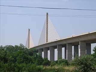
The Senator William V. Roth Jr. Bridge is a concrete and steel cable-stayed bridge that spans the Chesapeake & Delaware Canal near St. Georges, Delaware. The bridge is located near a tolled section of Delaware Route 1 that runs parallel to the St. Georges Bridge carrying U.S. Route 13. In November 2006, the bridge was named after U.S. Senator William V. Roth, Jr., who not only lent his name to the Roth IRA, but was instrumental in securing federal funding to build the bridge. It is owned and operated by the U.S. Army Corps of Engineers and does not carry a toll, despite the location of a nearby toll plaza.

The Industrial Canal is a 5.5 mile (9 km) waterway in New Orleans, Louisiana, United States. The waterway's proper name, as used by the U.S. Army Corps of Engineers and on NOAA nautical charts, is Inner Harbor Navigation Canal (IHNC). The more common "Industrial Canal" name is used locally, both by commercial mariners and by landside residents.

The Cape Cod Canal Railroad Bridge, a vertical lift bridge in Bourne, Massachusetts near Buzzards Bay, carries railroad traffic across the Cape Cod Canal, connecting Cape Cod with the mainland.

Maryland Route 537 is a collection of unsigned state highways in the U.S. state of Maryland. These two existing highways and two former sections of state highway are segments of the old alignment of U.S. Route 213, which is now MD 213, in Chesapeake City in southern Cecil County. Some of the roads that became segments of MD 537 were constructed in the mid-1910s as part of the original state road between Elkton and Cecilton. Other portions of MD 537 were part of the approach roads to a bridge across the Chesapeake & Delaware Canal that was built in the mid-1920s and destroyed in 1942. After the modern Chesapeake City Bridge and its approach roads were completed in 1949, US 213 was moved to the new bridge and approach roads and MD 537 was assigned to the bypassed sections of US 213. Much of MD 537 outside of Chesapeake City was transferred to county maintenance in the late 1950s. In 2015, the remaining section of MD 537 north of the canal was turned over to municipal maintenance.
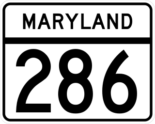
Maryland Route 286 is a state highway in the U.S. state of Maryland. Known for most of its length as Bethel Road, the highway runs 2.09 miles (3.36 km) from George Street, which is one of the segments of unsigned MD 537, east through Chesapeake City to the Delaware state line, where the highway continues east as Delaware Route 286. MD 286 roughly parallels the south side of the Chesapeake & Delaware Canal in southern Cecil County. The highway was constructed around 1930 and originally served the former community of Bethel instead of crossing the state line. A connection to Delaware was added in the late 1940s, and the segment to Bethel was removed in the late 1950s. MD 286's course within Chesapeake City was changed to its present routing in the mid-1960s.

Maryland Route 285 is a state highway in the U.S. state of Maryland. The highway runs 2.43 miles (3.91 km) from MD 213 east through Chesapeake City to the Delaware state line in southern Cecil County. MD 285 consists of two sections. The first section parallels the north side of the Chesapeake & Delaware Canal; this portion was constructed around 1930. The other segment included sections of the main north–south highway through Chesapeake City, U.S. Route 213. Sections of the main highway were constructed in the mid-1910s and then in the mid-1920s concurrent with the second bridge across the canal. After US 213 was moved to MD 213's present course using the Chesapeake City Bridge in 1949, the old highway became part of MD 537. That portion of MD 537 was replaced by an extension of MD 285 to MD 213 in 1983.

The St. Georges Bridge is a steel tied arch bridge that carries U.S. Route 13 (US 13) across the Chesapeake & Delaware Canal in St. Georges, Delaware. Built by the U.S. Army Corps of Engineers and opened in 1942 as a high-level crossing, the bridge was the first four-lane, high-level crossing to span the canal. It replaced a previous vertical lift bridge which was damaged when a German merchant ship collided with it.

The Reedy Point Bridge carries Delaware Route 9 across the Chesapeake & Delaware Canal in Delaware City, Delaware, USA. A two-lane cantilever bridge similar in appearance to the Platt Bridge in Southwest Philadelphia, the Reedy Point Bridge was built by the U.S. Army Corps of Engineers and opened in 1968, replacing a lift bridge that crossed the C&D Canal prior to the 1955 widening project. Unlike the nearby St. Georges Bridge, the Reedy Point Bridge spans over salt marshes at the southern approach, the canal itself, and both Fort Dupont and the Governor Bacon Health Center. An obsolete double-leaf bascule drawbridge, located just less than ⅛ of a mile north of the northern abutment, allows Delaware Route 9 to cross over the Delaware Ship Channel and is technically part of the Reedy Point Bridge system. Both the high-level bridge and the drawbridge are maintained by the U.S. Army Corps of Engineers. In 2018, the old drawbridge was replaced with a fixed span.

The Chesapeake & Delaware Canal Lift Bridge is a railroad bridge with vertical-lift span in the U.S. state of Delaware. It carries a Delmarva Central Railroad rail line across the Chesapeake & Delaware Canal.

The Summit Bridge carries Delaware Routes 71 and 896 across the Chesapeake & Delaware Canal. The bridge also carries Delaware Bicycle Route 1, a bicycle route that spans the length of the state of Delaware, across the canal. The Summit Bridge opened to traffic on January 9, 1960, replacing a lift bridge. Before the bridge opened to traffic, a dedication ceremony was held, with U.S. Senator J. Allen Frear Jr. in attendance. The Summit Bridge was the second four-lane high-level crossing in Delaware and was designed to carry an eventual US 301 freeway, however that planned freeway was never built on the alignment utilizing the Summit Bridge. US 301 did use the bridge when it was routed along surface roads from 1961 to 2019, at which time it was rerouted onto a new toll freeway. The current bridge replaces a former swing span structure that was demolished when the U.S. Army Corps of Engineers rerouted the canal to a new sea-level channel south of Lums Pond State Park. A construction project on the approaches to the bridge was completed in Fall of 2012.

Sinepuxent Bay is an inland waterway which connects Chincoteague Bay to Isle of Wight Bay, and is connected to the Atlantic Ocean via the Ocean City Inlet. It separates Sinepuxent Neck, in Worcester County, Maryland from Assateague Island, and West Ocean City, Maryland from downtown Ocean City. Islands in the Sinepuxent Bay include Horn Island and Skimmer Island. It is crossed by the Harry W. Kelley Memorial Bridge on U.S. Route 50 and the Verrazano Bridge on Maryland Route 611. The bay is the location of the islands that compose the Sinepuxent Bay Wildlife Management Area. Historically the area was referred to by various names including Sinepuxent, Sene Puxon, Synepuxent, Cinnepuxon, et al.

Delaware Route 896 (DE 896) is a state highway located in New Castle County, Delaware. The route runs from U.S. Route 13 (US 13) in Boyds Corner north to the Maryland border northwest of Newark, where the road becomes unsigned Maryland Route 896 (MD 896) briefly before heading into Pennsylvania as Pennsylvania Route 896 (PA 896). The route heads west from US 13 before turning north along with DE 71 in Mount Pleasant, crossing the Chesapeake & Delaware Canal on the Summit Bridge. After the bridge, DE 71 splits off to the east and the road continues to Glasgow, where it comes to an intersection with US 40. DE 896 continues north and interchange with Interstate 95 (I-95) before reaching Newark, where it bypasses the University of Delaware to the west by following DE 4, Elkton Road, and South Main Street. DE 896 comes to downtown Newark and continues northwest to the Maryland border. DE 896 has a business route, DE 896 Business, that passes through Glasgow, and had an alternate alignment south of Glasgow called DE 896 Alternate.
U.S. Route 13 (US 13) is a U.S. highway running from Fayetteville, North Carolina, north to Morrisville, Pennsylvania. In the U.S. state of Delaware, the route runs for 103.33 mi (166.29 km). It traverses the entire north–south length of the state from the Maryland state line in Delmar, Sussex County, north to the Pennsylvania state line in Claymont, New Castle County. US 13 connects many important cities and towns in Delaware, including Seaford, Dover, and Wilmington. The entire length of US 13 in Delaware is a multilane divided highway with the exceptions of the segment through Wilmington and parts of the route in Claymont. Between the Maryland state line and Dover, US 13 serves as one of the main north–south routes across the Delmarva Peninsula. From Dover north to Tybouts Corner, the route is followed by the controlled-access Delaware Route 1 (DE 1) toll road, which crosses the route multiple times and has multiple interchanges with it. US 13 bypasses downtown Wilmington to the east before it heads northeast of the city parallel to Interstate 495 (I-495) and the Delaware River to Claymont. US 13 is the longest numbered highway in the state of Delaware.
Canal Parkway, which carries the unsigned Maryland Route 61 designation, is a state highway and automobile parkway in the U.S. state of Maryland. The road begins at the West Virginia state line at the North Branch Potomac River opposite Wiley Ford, where the highway continues south as West Virginia Route 28. The parkway runs 1.94 miles (3.12 km) north to MD 51 within the city of Cumberland. Canal Parkway provides a connection between downtown Cumberland and the South Cumberland neighborhood and with Greater Cumberland Regional Airport, which is located in Mineral County, West Virginia.

