
Minnesota is a state in the upper Midwestern United States. It is the 12th largest U.S. state in area and the 22nd most populous, with over 5.7 million residents. More than half of Minnesotans live in the Minneapolis–Saint Paul metropolitan area, known as the "Twin Cities", which is the main political, economic, and cultural hub. The Twin Cities are among the 20 largest metropolises in the U.S. Other Minnesota metropolitan areas include Duluth, Mankato, Moorhead, Rochester and St. Cloud. Minnesota's geography is highly diverse, consisting of western prairies, now given over to intensive agriculture; deciduous forests in the southeast, now partially cleared, farmed, and settled; and the less populated North Woods, used for mining, forestry, and recreation. Roughly a third of the state is forested, and it is known as the "Land of 10,000 Lakes" for having over 14,000 bodies of fresh water that are at least ten acres.

Saint Paul is the capital of the U.S. state of Minnesota. It is the county seat of Ramsey County, the state's smallest in terms of area, second-most populous, and most densely populated county. As of 2020, its population was 311,527, making it the 63rd-largest city in the United States and the 11th-most populous in the Midwest. Most of the city lies east of the Mississippi River at the confluence with the Minnesota River. Minneapolis, the state's largest city, is across the river to the west. Together, they are known as the "Twin Cities". They are the core of Minneapolis–Saint Paul metropolitan area, home to over 3.6 million and the third-largest in the Midwest.

Cass Gilbert was a prominent American architect. An early proponent of skyscrapers, his works include the Woolworth Building, the United States Supreme Court building, the state capitols of Minnesota, Arkansas and West Virginia; and the Saint Louis Art Museum and Public Library. His public buildings in the Beaux Arts style reflect the optimistic American sense that the nation was heir to Greek democracy, Roman law and Renaissance humanism. Gilbert's achievements were recognized in his lifetime; he served as president of the American Institute of Architects in 1908–09.
Minnesota Public Radio (MPR), is a public radio network for the state of Minnesota. With its three services, News & Information, YourClassical MPR and The Current, MPR operates a 46-station regional radio network in the upper Midwest.
Interstate 94 (I-94) is an east–west Interstate Highway connecting the Great Lakes and northern Great Plains regions of the United States. Its western terminus is in Billings, Montana, at a junction with I-90; its eastern terminus is in Port Huron, Michigan, where it meets with I-69 and crosses the Blue Water Bridge into Sarnia, Ontario, Canada, where the route becomes Ontario Highway 402. It thus lies along the primary overland route from Seattle to Toronto, and is the only east–west Interstate highway to have a direct connection to Canada.

Minneapolis–Saint Paul is a major metropolitan area built around the confluence of the Mississippi, Minnesota and St. Croix rivers in east central Minnesota. The area is commonly known as the Twin Cities after its two largest cities, Minneapolis, the most populous city in the state and home of the largest university in the state, and Saint Paul, the state capital, which directly borders Minneapolis to the east. It is an example of twin cities in the sense of geographical proximity. Minnesotans often refer to the two together simply as "the Cities".

Fridley is a city in Anoka County, Minnesota, United States. Its population was 27,208 at the 2010 census. Fridley was incorporated in 1949 as a village, and became a city in 1957. It is part of the Twin Cities metropolitan area. Fridley is a "first ring" or "inner ring" suburb in the northern part of the Twin Cities. Fridley connects with the city of Minneapolis at its southern border. Neighboring first-ring suburbs are Columbia Heights to the south and Brooklyn Center to the west across the Mississippi River.
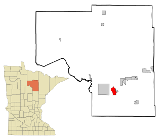
Grand Rapids is a city in and the county seat of Itasca County, Minnesota, United States. The population was 10,869 at the 2010 census. The city is named for the 3.5-mile (5.6 km) long local rapids in the Mississippi River, which was the uppermost limit of practical steamboat travel during the late 19th century. Today the rapids are hidden below the dam of the Blandin Paper Mill.

Rochester is a city founded in 1854 in the U.S. state of Minnesota and is the county seat of Olmsted County located on the Zumbro River's south fork in Southeast Minnesota. It is Minnesota's third-largest city and the largest city located outside the Minneapolis-St. Paul-Bloomington Metropolitan Statistical Area. According to the 2020 United States Census, the city had a population of 121,395. The surrounding metropolitan area has a population of 226,329. It is the home of the Mayo Clinic and a major IBM facility, one of the company's largest at its peak.

Bloomington is the fourth largest city, as of 2018 estimates, in the U.S. state of Minnesota. It is located in Hennepin County on the north bank of the Minnesota River, above its confluence with the Mississippi River. Bloomington lies 10 miles (16 km) south of downtown Minneapolis. As of the 2020 census the city's population was 89,987.

The University of Minnesota, Twin Cities is a public land-grant research university in the Twin Cities of Minneapolis and Saint Paul, Minnesota. The Twin Cities campus comprises locations in Minneapolis and Falcon Heights, a suburb of St. Paul, approximately 3 miles (4.8 km) apart. The Twin Cities campus is the oldest and largest in the University of Minnesota system and has the ninth-largest main campus student body in the United States, with 51,327 students in 2019–20. It is the flagship institution of the University of Minnesota System, and is organized into 19 colleges, schools, and other major academic units.

Nicollet Avenue is a major street in Minneapolis, Richfield, Bloomington, and Burnsville in the U.S. state of Minnesota. It passes through a number of locally well-known neighborhoods and districts, notably Eat Street in south Minneapolis and the traffic-restricted Nicollet Mall in downtown Minneapolis.

KUOM – branded Radio K – is a daytime-only non-commercial educational college/alternative rock radio station licensed to serve Minneapolis, Minnesota. KUOM covers the Minneapolis–Saint Paul metropolitan area, and extends its reach with two low-power broadcast relay stations and one full-power repeater. Owned by the University of Minnesota, Twin Cities, the station is operated by both faculty and students. The KUOM studios are located at the Rarig Center on the University of Minnesota campus, while the station transmitter is in Falcon Heights. Besides a standard analog transmission, KUOM is also available online.
Minneapolis–Saint Paul, also known as the Twin Cities of Minneapolis and Saint Paul, in the state of Minnesota, United States of America, has two major general-interest newspapers. The region is currently ranked as the 15th largest television market in the United States. The market officially includes 59 counties of Minnesota and Wisconsin, and extends far to the north and west. The radio market in the Twin Cities is estimated to be slightly smaller, ranked 16th in the nation.
KWCM-TV, virtual and VHF digital channel 10, is a Public Broadcasting Service (PBS) member television station licensed to Appleton, Minnesota, United States. The station is owned by the West Central Minnesota Educational TV Corp. KWCM-TV's studios are located on West Schlieman Avenue in Appleton, and its transmitter is located southeast of the city.

SouthWest Transit is a public transportation agency that is based in Eden Prairie, Minnesota. The agency was formed in 1986 when the southwest Minneapolis suburbs of Chaska, Chanhassen, and Eden Prairie chose to opt out of the Metropolitan Transit Commission transit system in accordance with Minnesota State Statutes. Under a joint powers agreement between the three cities, they created their own transit system, SouthWest Metro Transit.
Georgetown or George Town may refer to:
The following outline is provided as an overview of and topical guide to the U.S. state of Minnesota:
The following television stations operate on virtual channel 42 in the United States: