Civic Center, Los Angeles

Last updated

Civic Center
Los Angeles City Hall (color) edit1.jpg
Los Angeles City Hall stands at the southern border of the Los Angeles Civic Center
Los Angeles Downtown locator.PNG
Red pog.svg
Civic Center
Location within Downtown Los Angeles
Coordinates: 34°03′15″N118°14′41″W / 34.054139°N 118.244659°W / 34.054139; -118.244659
CountryFlag of the United States.svg  United States
StateFlag of California.svg  California
CountyFlag of Los Angeles County, California.svg Los Angeles
CityFlag of Los Angeles, California.svg  Los Angeles
Area code 213

The Civic Center neighborhood of Los Angeles, California, is the administrative core of the City of Los Angeles, County of Los Angeles, and a complex of city, county, state, and federal government offices, buildings, and courthouses. It is located on the site of the former business district of the city during the 1880s and 1890s, since mostly-demolished.

Contents

Location

The Civic Center is located in the northern part of Downtown Los Angeles, bordering Bunker Hill, Little Tokyo, Chinatown, and the Historic Core of the old Downtown. Depending on various district definitions, either the Civic Center or Bunker Hill also contains the Music Center and adjacent Walt Disney Concert Hall; some maps, for example, place the Dorothy Chandler Pavilion in the Civic Center but the Disney Concert Hall in Bunker Hill.

The Civic Center has the distinction of containing the largest concentration of government employees in the United States outside of Washington, D.C. [1] The reason for the high concentration is simple: Los Angeles is the most populous county in the United States and its second largest city, and houses several state and federal functions for the region.

Other locations

Los Angeles' 1949 master plan called for branch administrative centers throughout the rapidly expanding city. [2] In addition to the main civic center downtown, there is the West Los Angeles Civic Center in the Westside (built between 1957 and 1965) and the Van Nuys Civic Center in the San Fernando Valley, as well as a neighborhood city hall in San Pedro. [2] [3]

Transportation

The Civic Center is served by numerous Metro buses, most of which run to adjacent Union Station, the 101 and 110 freeways, and the Metro B Line and D Line's Civic Center/Grand Park station are also in the vicinity. OCTA, Foothill Transit, DASH shuttles, Commuter Express and other municipal bus lines also serve the area.[ citation needed ]

The Regional Connector that opened on June 16, 2023, serves this area with two stations at Grand Avenue Arts/Bunker Hill station and Historic Broadway. [4]

History and planning

Part of what is now the Civic Center occupies what was the central business district (CBD) of the 1880s and 1890s, which was first centered at the southern end of the Los Angeles Plaza and grew to the south and west along Main Street, Spring Street and Broadway, with Third & Broadway forming its southwestern anchor by the mid-1890s. [5] As upscale businesses moved further south into the Historic Core around 1900–1910, the Victorian-era blocks became the "north end" of the business district and became increasingly neglected.

There were numerous grand plans for a coherent, modern civic center. Charles Mulford Robinson's 1909 plan focused on only a few major buildings between Main, Broadway, First and Temple. Lyman Farewell, Cook and Hall, the Allied Architects Association, the Regional Planning Commission, Frank Lloyd Wright, William Lee Woollett, Stanton & Stockwell, and landscape architect Ralph Cornell all contributed plans or partial plans, through the late 1950s. There was a "Mulholland Committee" to adopt one, and the location was put to the public for a vote in the late 1920s. The public voted overwhelmingly to confirm the location, but the city and county differed on which plan to adopt. There was later a Civic Center Advisory Committee and then in 1945, a Los Angeles Civic Center Authority. But never was a single plan adopted. Nonetheless, construction of the various buildings proceeded one by one, starting with the City Hall and the Hall of Justice in the 1920s, [6] and the California State Building (already demolished) in 1931.

One of these plans which was not adopted in its entirety, the 1947 Civic Center Master Plan, nonetheless envisioned the demolition of the once-tony residential area Bunker Hill, which happened in the 1950s and allowed the Civic Center to expand westward across the northern section of that neighborhood (from Temple south to Second St.). The plan also conceived two County buildings: Stanley Mosk Courthouse completed in 1958, the Kenneth Hahn Hall of Administration opening in 1960, designed by Stanton, Stockwell, Williams and Wilson in Late Moderne style, flanking either side of a new pedestrian mall, Civic Center Mall, now part of Grand Park. [7] [8] A new Los Angeles County Hall of Records arose nearby in 1962. The 1955, Parker Center, headquarters for the Los Angeles Police Department until 2009, opened on the east side of Los Angeles Street, pushing the civic district's eastern boundary to Alameda Street, establishing the current Civic Center footprint such that now nearly the entire area between Hope and Los Angeles streets, US-101, and Second Street, consists of civic buildings - the single large exception being the city block called Times Mirror Square, former headquarters of the Los Angeles Times newspaper.

As part of the Grand Avenue Project, Grand Park was created in 2012, encompassing the former Civic Center Mall and additional areas such that it now stretches from the Los Angeles Music Center complex to City Hall.

Now, the city looks to bring pedestrian life into the area. In March 2017, the Los Angeles City Council approved a new Civic Center Master Plan (CCMP). It details a full build out around city hall by the year 2032, specifically the east facing front. The CCMP schedules for a full tear down of Parker Center (torn down in 2019), L.A. City Hall's "south" building, and the Los Angeles Mall. The CCMP is to connect City Hall in a pedestrian-friendly way with its surrounding neighborhood and Little Tokyo. [9] The CCMP calls for active ground-floor uses, to stimulate the pedestrian traffic that the Civic Center currently lacks. Four new government and office towers are described in the plan as well as the planned Park 101 recreational area. A design approach idea to cover U.S. Highway 101 as a trench with green space above. Connecting with Union Station and Olvera Street. [10]

Buildings and landmarks

View of the Civic Center from Dodger Stadium. View of Los Angeles Civic Center from Dodger Stadium, Los Angeles, California.jpg
View of the Civic Center from Dodger Stadium.
City Hall is often lit with various colors at night. Los Angeles Civic Center at night.jpg
City Hall is often lit with various colors at night.

West side of Figueroa between Temple and First:

Between Figueroa and Hope:

Between Hope and Grand:

Between Grand and Hill:

Between Hill and Broadway:

Between Broadway and Spring:

Between Spring and Main:

Between Main and Los Angeles St.:

Between Los Angeles St. and Alameda:

County representation

The Los Angeles County Department of Health Services operates the Central Health Center in Downtown Los Angeles, serving the Civic Center. [11]

See also

Related Research Articles

<span class="mw-page-title-main">Downtown Los Angeles</span> Neighborhood in Los Angeles, California

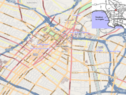
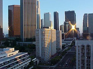
Downtown Los Angeles (DTLA) contains the central business district of Los Angeles. In addition, it contains a diverse residential area of some 85,000 people, and covers 5.84 sq mi (15.1 km2). A 2013 study found that the district is home to over 500,000 jobs. It is also part of Central Los Angeles.

<span class="mw-page-title-main">Los Angeles City Hall</span> 1928 building housing the government of the city of Los Angeles, California

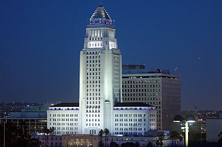
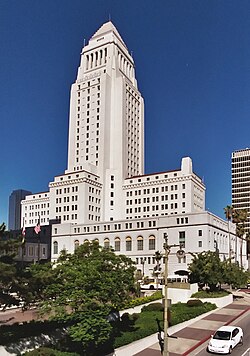
Los Angeles City Hall, completed in 1928, is the center of the government of the city of Los Angeles, California, and houses the mayor's office and the meeting chambers and offices of the Los Angeles City Council. It is located in the Civic Center district of downtown Los Angeles in the city block bounded by Main, Temple, First, and Spring streets, which was the heart of the city's central business district during the 1880s and 1890s.

Bunker Hill is a neighborhood in Los Angeles, California. It is part of Downtown Los Angeles.

<span class="mw-page-title-main">Broadway (Los Angeles)</span> Department stores list in Los Angeles

Broadway, until 1890 Fort Street, is a thoroughfare in Los Angeles County, California, United States. The portion of Broadway from 3rd to 9th streets, in the Historic Core of Downtown Los Angeles, was the city's main commercial street from the 1910s until World War II, and is the location of the Broadway Theater and Commercial District, the first and largest historic theater district listed on the National Register of Historic Places (NRHP). With twelve movie palaces located along a six-block stretch of Broadway, it is the only large concentration of movie palaces left in the United States.

The Grand Avenue Project was a government lead revitalization effort for the Bunker Hill neighborhood of Downtown Los Angeles on Grand Avenue and centered around Grand Park, its surrounding county government buildings and its parking lots. It was administered by the Grand Avenue Authority, a joint powers authority consisting of Los Angeles County and City. The first task was to improve the streetscape of Grand Avenue. The second element was to upgrade the 12-acre (4.9 ha) Grand Park in 2012 with a refurbished fountains, lawn furniture, walkways and the planting of native gardens. And lastly, constructing several residential buildings, including a two-tower complex on the southeast corner of Grand Avenue and 1st Street, designed by Frank Gehry.

<span class="mw-page-title-main">Financial District, Los Angeles</span> Neighborhood of Los Angeles in County of Los Angeles, California, United States

The Financial District is the central business district of Los Angeles along Olive, Grand, Hope, Flower and Figueroa streets from 4th Street to 8th Street. It is south of the Bunker Hill district, west of the Historic Core, north of South Park and east of the Harbor Freeway and Central City West. Like Bunker Hill, the Financial District is home to corporate office skyscrapers, hotels and related services as well as banks, law firms, and real estate companies. However, unlike Bunker Hill which was razed and now consists of buildings constructed since the 1960s, it contains large buildings from the early 20th century, particularly along Seventh Street, once the city's upscale shopping street; the area also attracts visitors as the 7th and Flower area is at the center of the regional Metro rail system and is replete with restaurants, bars, and shopping at two urban malls.

<span class="mw-page-title-main">Regional Connector</span> Transit project in Los Angeles

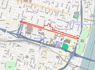
The Regional Connector Transit Project constructed a 1.9-mile (3.1 km) light rail tunnel for the Los Angeles Metro Rail system in Downtown Los Angeles. It connected the A and E lines with the former L Line. The A and E lines previously both terminated at 7th Street/Metro Center station, while the L Line ran through Little Tokyo/Arts District to either Azusa or East Los Angeles. The project provides a one-seat ride into the core of Downtown for passengers on those lines who previously needed to transfer, thus reducing or altogether eliminating many transfers of passengers traveling across the region via Downtown Los Angeles.

<span class="mw-page-title-main">Downtown Santa Ana</span> United States historic place

Downtown Santa Ana (DTSA), also called Downtown Orange County, is the city center of Santa Ana, the county seat of Orange County, California. It is the institutional center for the city of Santa Ana as well as Orange County, a retail and business hub, and has in recent years developed rapidly as a regional cultural, entertainment, and culinary center for Orange County.

Oakland's Civic Center neighborhood is a residential and public building district on the east side of Oakland's Central Business District. Its borders are roughly Downtown and Harrison Street to the west, the East Lake Neighborhood and Lakeshore Avenue to the east, the Lakeside Apartments District and 14th Street to the North, and Chinatown and 11th Street to the South.

<span class="mw-page-title-main">Hill Street (Los Angeles)</span> Street in Los Angeles, California, United States

Hill Street is a major north–south thoroughfare in Los Angeles, measuring 4.8 miles (7.7 km) in length. It starts on Martin Luther King, Jr. Boulevard near the campus of USC, and passes north through Downtown Los Angeles, past such landmarks as Pershing Square, the Subway Terminal Building, Angels Flight, Fort Moore and Chinatown. Hill Street merges with the Arroyo Seco Parkway near Dodger Stadium.

<span class="mw-page-title-main">St. Louis Gateway Mall</span>

The Gateway Mall in St. Louis, Missouri is an open green space running linearly, one block wide, from the Gateway Arch at Memorial Drive to Union Station at 20th Street. Located in the city's downtown, it runs between Market Street and Chestnut Street.

<span class="mw-page-title-main">Grand Avenue (Los Angeles)</span>

Grand Avenue is a major north–south thoroughfare in Los Angeles, California. Lined with museums, concert venues, and theaters, this urban center on Bunker Hill attracts millions of people a year. Grand Park stretches between the Los Angeles City Hall and the Los Angeles Music Center on Grand Avenue. In 2007, a $3 billion Grand Avenue Project was proposed to revive Downtown Los Angeles.

<span class="mw-page-title-main">Grand Park</span> Park in Los Angeles, California

Gloria Molina Grand Park, commonly known as Grand Park, is a 12-acre (4.9 ha) park located in the civic center of Los Angeles, California. First developed in 1966 as the 'Civic Center Mall' with plazas, fountains and a Court of Flags, it is now a part of the larger redevelopment known as the Grand Avenue Project, with its first phase having opened in July 2012. Grand Park is part of a joint venture by the city of Los Angeles and Los Angeles County. It was designed and built by the Los-Angeles–based multidisciplinary design firm Rios Clementi Hale Studios. Park programming and entertainment, security and upkeep are maintained by the nearby Los Angeles Music Center.

<span class="mw-page-title-main">Kenneth Hahn Hall of Administration</span> Seat of government for Los Angeles County, California

Kenneth Hahn Hall of Administration, formerly the Los Angeles County Hall of Administration, completed 1960, is the seat of the government of the County of Los Angeles, California, and houses the Los Angeles County Board of Supervisors, meeting chambers, and the offices of several County departments. It is located in the Civic Center district of downtown Los Angeles, encompassing a city block bounded by Grand, Temple, Hill, and Grand Park.

<span class="mw-page-title-main">Grand Avenue Arts/Bunker Hill station</span> Light rail station

Grand Avenue Arts/Bunker Hill station is an underground light rail station on the A and E lines of the Los Angeles Metro Rail system. The station also has street level stops for the J Line of the Los Angeles Metro Busway system. The station is located under the intersection of 2nd Place and Hope Street, near the Grand Avenue Arts district and in the Bunker Hill neighborhood of Downtown Los Angeles, after which the station is named. In planning documents, the station was originally referred to as 2nd Place/Hope.

<span class="mw-page-title-main">Victorian Downtown Los Angeles</span> Historical neighborhood in California, US

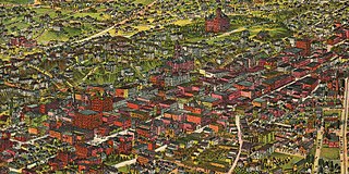
The late-Victorian-era Downtown of Los Angeles in 1880 was centered at the southern end of the Los Angeles Plaza area, and over the next two decades, it extended south and west along Main Street, Spring Street, and Broadway towards Third Street. Most of the 19th-century buildings no longer exist, surviving only in the Plaza area or south of Second Street. The rest were demolished to make way for the Civic Center district with City Hall, numerous courthouses, and other municipal, county, state and federal buildings, and Times Mirror Square. This article covers that area, between the Plaza, 3rd St., Los Angeles St., and Broadway, during the period 1880 through the period of demolition (1920s–1950s).

<span class="mw-page-title-main">History of retail in Southern California</span> Department stores list in Los Angeles

Retail in Southern California dates back to its first dry goods store that Jonathan Temple opened in 1827 on Calle Principal, when Los Angeles was still a Mexican village. After the American conquest, as the pueblo grew into a small town surpassing 4,000 population in 1860, dry goods stores continued to open, including the forerunners of what would be local chains. Larger retailers moved progressively further south to the 1880s-1890s Central Business District, which was later razed to become the Civic Center. Starting in the mid-1890s, major stores moved ever southward, first onto Broadway around 3rd, then starting in 1905 to Broadway between 4th and 9th, then starting in 1915 westward onto West Seventh Street up to Figueroa. For half a century Broadway and Seventh streets together formed one of America's largest and busiest downtown shopping districts.

<span class="mw-page-title-main">Los Angeles Mall</span> Shopping center and public plaza complex in Los Angeles, California

The Los Angeles Mall is a small shopping center and series of plazas at the Los Angeles Civic Center, between Main and Los Angeles Streets on the north and south sides of Temple Street, connected by both a pedestrian bridge and a tunnel. It features Joseph Young's sculpture Triforium, a colorful sculpture unveiled in 1975, which has 1,500 blown-glass prisms synchronized to an electronic glass bell carillon. The mall opened in 1974 and includes a four-level parking garage with 2,400 spaces. It stands on the site of what once was some of the oldest commercial blocks in the city that was demolished in the 1940s and 1950s.

<span class="mw-page-title-main">Stanton & Stockwell</span>

Stanton & Stockwell was a partnership of Jesse Earl Stanton and William Francis Stockwell, two architects active in Southern California during the mid-20th century. Works attributed to them include:

<span class="mw-page-title-main">Stanley Mosk Courthouse</span> Courthouse in Los Angeles, United States

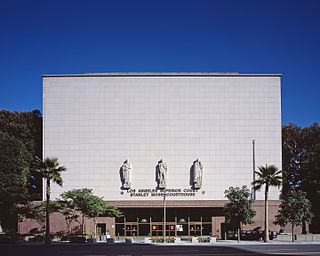
The Stanley Mosk Courthouse is a courthouse in Los Angeles, California home to the Los Angeles County Superior Court. It is located at 110 N. Grand Avenue and 111 N. Hill Street between Temple and First streets, lining Grand Park in the Civic Center in Downtown Los Angeles. The building was constructed in 1958 and has a floor area of 220,860 square feet (20,519 m2) in its west wing and 515,340 square feet (47,877 m2) in the east wing. It has 100 courtrooms, 840 daily workers and 7000 daily visitors. The courthouse is often seen in the TV series Perry Mason, when the title character parks his car on Hill Street to go inside the building.

References

  1. "Civic Center". Downtown LA Walks. Archived from the original on February 26, 2012. Retrieved November 1, 2012.
  2. 1 2 "West Los Angeles Civic Center | Los Angeles Conservancy". www.laconservancy.org.
  3. "City Hall & Neighborhood City Halls".
  4. Nolan, Conan (June 16, 2023). "Need a ride? Metro to open its Regional Connector system". Los Angeles. Retrieved June 16, 2023.
  5. "The Opening of North Broadway". Los Angeles Times. October 9, 1895. p. 6.
  6. "When Plans Fail: A Century's Worth of Unrealized Visions for the L.A. Civic Center". KCET. February 16, 2017.
  7. "Stanley Mosk Courthouse / Los Angeles County Courthouse". Explore L.A. Los Angeles Conservancy. Retrieved September 11, 2013.
  8. "Stanton, Stockwell, Williams and Wilson, Associated Architects (Association)", Pacific Coast Architecture Database
  9. "Civic Center District Design Guidelines Community MTG #3 Open House" (PDF). February 13, 2019.
  10. "A Look at the Civic Center of the Future". April 5, 2017.
  11. " "Central Health Center" (PDF). Los Angeles County Department of Health Services . Retrieved March 18, 2010.