Moselle is the most populous department in Lorraine, in the east of France, and is named after the river Moselle, a tributary of the Rhine, which flows through the western part of the department. Inhabitants of the department are known as Mosellans.

The Imperial Territory of Alsace-Lorraine was a territory created by the German Empire in 1871 after it annexed most of Alsace and the Moselle department of Lorraine following its victory in the Franco-Prussian War. The Alsatian part lay in the Rhine Valley on the west bank of the Rhine River and east of the Vosges Mountains. The Lorraine section was in the upper Moselle valley to the north of the Vosges.

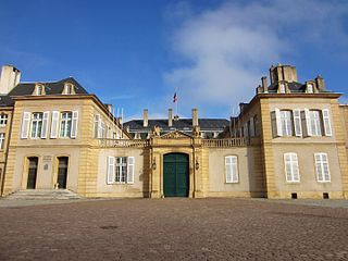
Thionville is a commune in the northeastern French department of Moselle. The city is located on the left bank of the river Moselle, opposite its suburb Yutz.
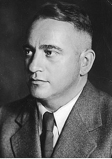
Joseph Bürckel was a Nazi Germany politician and a member of the German parliament. He was an early member of the Nazi Party and was influential in the rise of the National Socialist movement. He played a central role in the German acquisition of the Saarland and Austria. He held the posts of Gauleiter and Reichsstatthalter in both Gau Westmark and Reichsgau Vienna.

Lorraine is a cultural and historical region in north-eastern France, now located in the administrative region of Grand Est. Lorraine's name stems from the medieval kingdom of Lotharingia, which in turn was named for either Emperor Lothair I or King Lothair II. It later was ruled as the Duchy of Lorraine before the Kingdom of France annexed it in 1766.
The arrondissement of Boulay-Moselle is a former arrondissement of France in the Moselle department in the Lorraine region. In 2015 it was merged into the new arrondissement of Forbach-Boulay-Moselle. It had 96 communes, and its population was 79,847 (2012).

The arrondissement of Forbach is a former arrondissement of France in the Moselle department in the Lorraine region. In 2015 it was merged into the new arrondissement of Forbach-Boulay-Moselle. It had 73 communes, and its population was 167,518 (2012).

The arrondissement of Thionville-Est is a former arrondissement of France in the Moselle department in the Lorraine region. In 2015 it was merged into the new arrondissement of Thionville. It had 75 communes, and its population was 79,847 (2012).

The Territory of the Saar Basin was a region of Germany occupied and governed by the United Kingdom and France from 1920 to 1935 under a League of Nations mandate. It had its own flag : a blue, white, and black horizontal tricolour. The blue and white stood for Bavaria, and white and black for Prussia, out of whose lands the Saar Territory was formed. Initially, the occupation was under the auspices of the Treaty of Versailles. Its population in 1933 was 812,000, and its capital was Saarbrücken. The territory closely corresponds with the modern German state of Saarland, but was slightly smaller in area. After a plebiscite was held in 1935, it was returned to Germany.

Petite-Rosselle is a commune in the Moselle department of the Grand Est region in north-eastern France. The commune is separated from neighbouring Großrosseln to its west by the small river Rossel, which forms the border between France and Germany. It has 6,322 inhabitants (2018).

The Gau Westmark was an administrative division of Nazi Germany from 1933 to 1945. From 1925 to 1933, it was a regional subdivision of the Nazi Party.
The 1st Canton of Saint-Avold is a French former administrative division, located in the arrondissement of Forbach, in the Moselle département. It was disbanded following the French canton reorganisation which came into effect in March 2015. It had 26,632 inhabitants as of 2012.
The 2nd Canton of Saint-Avold is a French former administrative division, located in the arrondissement of Forbach, in the Moselle département. It was disbanded following the French canton reorganisation which came into effect in March 2015. It had 21,046 inhabitants in 2012.
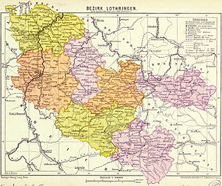
Bezirk Lothringen, also called German Lorraine, was a government region ("Bezirk") in the western part of Alsace-Lorraine when it was part of the German Empire from 1871 to 1918.
The Protestant Church of the Augsburg Confession of Alsace and Lorraine is a Lutheran church of public-law corporation status in France. The ambit of the EPCAAL comprises congregations in Alsace and the Lorrain Moselle department.

The 6th constituency of Moselle is one of the nine legislative constituencies in the Moselle département (Lorraine).

The region of German Lorraine was the German-speaking part of Lorraine, now in France, that existed for centuries until into the 20th century. The name is also used more specifically in to refer to Bezirk Lothringen, that part of Lorraine that belonged to the German Empire from 1871 to 1918.

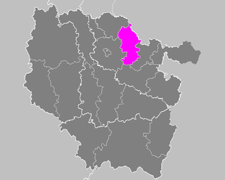
The arrondissement of Forbach-Boulay-Moselle is an arrondissement of France in the Moselle department in the Grand Est region. It has 169 communes. Its population is 243,054 (2016), and its area is 1,283.3 km2 (495.5 sq mi).

Chief of Civil Administration was an office introduced in Nazi Germany, operational during World War II. Its task was to administer civil issues according to occupation law, with the primary purpose being the support of the military command in the operational areas of the German Army. CdZ would pass his authority to a corresponding civil government after the territory in question became in the rear of the operating armed forces.

