Climate of Paraguay

Last updated
Paraguay map of Koppen climate classification. Koppen-Geiger Map PRY present.svg
Paraguay map of Köppen climate classification.

The climate of Paraguay consists of a subtropical climate in the Paranaense region and a tropical climate in the Chaco. The Paranaense region has a humid climate, with abundant rainfall throughout the year and only moderate seasonal changes in temperature.

Contents

The seasons in Paraguay are opposite to those in the northern hemisphere, meaning northern summer is Paraguayan winter, and vice versa.

During summer, the dominant influence on the climate is the warm sirocco winds blowing out of the northeast.

During the winter, the dominant wind is the cold pampero from the South Atlantic, which blows across Argentina and is deflected northeastward by the Andes in the southern part of that country. Because of the lack of topographic barriers within Paraguay, these opposite prevailing winds bring about abrupt and irregular changes in the usually moderate weather. Winds are generally brisk. Velocities of 160 kilometres per hour (99 mph) have been reported in southern locations, and the town of Encarnación was once leveled by a tornado.

Paranaense region

The Paranaense region has only two distinct seasons: summer from October to March and winter from May to August. In transitional months of April and September, temperatures below the midsummer averages include nocturnal minima that may dip below freezing.

Winter

During July, the coldest month of the subtropical winter in the Southern Hemisphere, temperature averages about 17.87 °C (64.17 °F) in Asunción and slightly cooler on the Paraná Plateau. Temperature varies only insignificantly with latitude. The number of days with temperatures falling below freezing ranges from as few as 3 to as many as 16 yearly, and with even wider variations deep in the interior. Some very mild winters with winds blowing constantly from the north feature little frost.

During a cold winter, however, tongues of Antarctic air bring subfreezing temperatures to all areas. No part of the Paranaense region is entirely free from risk of frost and consequent damage to crops, and various locations report snow flurries occasionally.

Summer

Moist tropical air keeps the weather warm in the Paranaense region from October through March. In Asunción the temperature averages about 27.96 °C (82.33 °F) during January, the warmest month.

During the summer, daytime temperatures fairly commonly reach 38 °C (100 °F). Frequent waves of cool air from the south, however, cause weather that alternates between clear, humid conditions and storms.

Precipitation

Fairly evenly distributed rain falls in the Paranaense region. Although local meteorological conditions play a contributing role, rain usually falls in dominant tropical air masses. The least rain falls in August, when averages in various parts of the region range from 100 millimetres (3.9 in) to 200 millimetres (7.9 in). The two periods of maximum precipitation are March through May and October to November.

For the region as a whole, the difference between the driest and the wettest months ranges from 100 millimetres (3.9 in) to 180 millimetres (7.1 in). The annual average rainfall is 1,270 millimetres (50 in), although the average on the Paraná Plateau is 250 millimetres (9.8 in) to 380 millimetres (15 in) greater. All subregions may experience considerable variations from year to year. Asunción has recorded as much as 208 millimetres (8.2 in) and as little as 560 millimetres (22 in) of annual rainfall; Puerto Bertoni on the Paraná Plateau has recorded as much as 3,300 millimetres (130 in) and as little as 790 millimetres (31 in).

Chaco

Temperature change in Paraguay since 1901 in the context of global warming. Temperature Bar Chart South America-Paraguay--1901-2020--2021-07-13.png
Temperature change in Paraguay since 1901 in the context of global warming.

In contrast to the Paranaense region, the Chaco has a tropical wet-and-dry climate bordering on semi-arid. The Chaco experiences seasons that alternately flood and parch the land, yet seasonal variations in temperature are modest. Chaco temperatures are usually high; the temperature drops only slightly in winter. Even at night the air is stifling despite the usually present breezes. Rainfall is light, varying from 500 to 1,000 millimeters (19.7 to 39.4 in) per year, except in the higher land to the northwest where it can be somewhat greater. Rainfall is concentrated in the summer months, and extensive areas that are deserts in winter become summer swamps.

Examples

Climate data for Asunción (1971–2000)
MonthJanFebMarAprMayJunJulAugSepOctNovDecYear
Record high °C (°F)42.0
(107.6)
39.6
(103.3)
40.0
(104.0)
37
(99)
35
(95)
33.0
(91.4)
33.4
(92.1)
39.2
(102.6)
42.2
(108.0)
42.8
(109.0)
40.2
(104.4)
41.7
(107.1)
42.8
(109.0)
Mean daily maximum °C (°F)33.5
(92.3)
32.6
(90.7)
31.6
(88.9)
28.4
(83.1)
25.0
(77.0)
23.1
(73.6)
23.2
(73.8)
24.8
(76.6)
26.4
(79.5)
29.2
(84.6)
30.7
(87.3)
32.3
(90.1)
28.3
(82.9)
Daily mean °C (°F)27.5
(81.5)
26.9
(80.4)
25.9
(78.6)
22.8
(73.0)
19.8
(67.6)
17.9
(64.2)
17.6
(63.7)
18.6
(65.5)
20.5
(68.9)
23.2
(73.8)
24.8
(76.6)
26.5
(79.7)
22.7
(72.9)
Mean daily minimum °C (°F)22.8
(73.0)
22.3
(72.1)
21.3
(70.3)
18.6
(65.5)
15.7
(60.3)
13.8
(56.8)
13.1
(55.6)
14.3
(57.7)
15.9
(60.6)
18.6
(65.5)
20.1
(68.2)
21.8
(71.2)
17.9
(64.2)
Record low °C (°F)12.5
(54.5)
12.5
(54.5)
9.4
(48.9)
6.8
(44.2)
2.6
(36.7)
−1.2
(29.8)
−0.6
(30.9)
0.0
(32.0)
3.6
(38.5)
7.0
(44.6)
8.8
(47.8)
10.0
(50.0)
−1.2
(29.8)
Average rainfall mm (inches)147.2
(5.80)
129.2
(5.09)
117.9
(4.64)
166.0
(6.54)
113.3
(4.46)
82.4
(3.24)
39.4
(1.55)
72.6
(2.86)
87.7
(3.45)
130.8
(5.15)
164.4
(6.47)
150.3
(5.92)
1,401.2
(55.17)
Average precipitation days (≥ 1.0 mm)87787745688883
Average relative humidity (%)68717275767670706667676870
Mean monthly sunshine hours 2762462542282051651952232042422702952,803
Source 1: World Meteorological Organization [1]
Source 2: NOAA updated to 9/2012., [2] Danish Meteorological Institute (sun only) [3]
Climate data for Ciudad del Este
MonthJanFebMarAprMayJunJulAugSepOctNovDecYear
Record high °C (°F)38.0
(100.4)
38.8
(101.8)
38.0
(100.4)
35.0
(95.0)
32.5
(90.5)
31.2
(88.2)
33.0
(91.4)
33.4
(92.1)
35.6
(96.1)
37.0
(98.6)
39.6
(103.3)
40.6
(105.1)
40.6
(105.1)
Mean daily maximum °C (°F)31.7
(89.1)
31.6
(88.9)
30.8
(87.4)
27.5
(81.5)
24.6
(76.3)
22.2
(72.0)
23.0
(73.4)
24.2
(75.6)
25.8
(78.4)
28.4
(83.1)
30.1
(86.2)
31.2
(88.2)
27.6
(81.7)
Daily mean °C (°F)26.1
(79.0)
25.8
(78.4)
24.7
(76.5)
21.5
(70.7)
18.4
(65.1)
16.3
(61.3)
16.4
(61.5)
17.6
(63.7)
19.3
(66.7)
22.1
(71.8)
24.1
(75.4)
25.6
(78.1)
21.5
(70.7)
Mean daily minimum °C (°F)21.1
(70.0)
21.3
(70.3)
20.1
(68.2)
17.2
(63.0)
13.6
(56.5)
11.4
(52.5)
11.3
(52.3)
12.3
(54.1)
13.8
(56.8)
16.6
(61.9)
18.3
(64.9)
20.1
(68.2)
16.4
(61.5)
Record low °C (°F)10.5
(50.9)
11.6
(52.9)
7.5
(45.5)
4.6
(40.3)
−0.2
(31.6)
0.0
(32.0)
−3.0
(26.6)
−1.0
(30.2)
0.8
(33.4)
4.0
(39.2)
6.4
(43.5)
8.2
(46.8)
−3.0
(26.6)
Average precipitation mm (inches)184.1
(7.25)
154.2
(6.07)
136.1
(5.36)
140.7
(5.54)
132.3
(5.21)
131.9
(5.19)
90.6
(3.57)
115.0
(4.53)
130.2
(5.13)
176.0
(6.93)
163.5
(6.44)
139.9
(5.51)
1,694.5
(66.71)
Average precipitation days (≥ 0.1 mm)10987887891099101
Average relative humidity (%)75777780838479777574727277
Source: NOAA [4] [5]
Climate data for Encarnación (1961–1990)
MonthJanFebMarAprMayJunJulAugSepOctNovDecYear
Record high °C (°F)40.5
(104.9)
39.4
(102.9)
39.3
(102.7)
35.4
(95.7)
34.0
(93.2)
31.6
(88.9)
32.4
(90.3)
34.8
(94.6)
36.6
(97.9)
38.0
(100.4)
40.4
(104.7)
42.0
(107.6)
42.0
(107.6)
Mean daily maximum °C (°F)31.2
(88.2)
30.6
(87.1)
29.2
(84.6)
25.9
(78.6)
23.2
(73.8)
20.9
(69.6)
21.4
(70.5)
22.5
(72.5)
23.9
(75.0)
26.5
(79.7)
28.4
(83.1)
30.5
(86.9)
26.2
(79.2)
Daily mean °C (°F)25.5
(77.9)
24.9
(76.8)
23.4
(74.1)
20.0
(68.0)
17.3
(63.1)
15.2
(59.4)
15.5
(59.9)
16.6
(61.9)
18.1
(64.6)
20.6
(69.1)
22.7
(72.9)
24.8
(76.6)
20.4
(68.7)
Mean daily minimum °C (°F)19.4
(66.9)
19.5
(67.1)
17.9
(64.2)
14.3
(57.7)
11.7
(53.1)
9.9
(49.8)
10.2
(50.4)
10.8
(51.4)
12.3
(54.1)
14.3
(57.7)
16.3
(61.3)
18.3
(64.9)
14.6
(58.3)
Record low °C (°F)9.3
(48.7)
7.0
(44.6)
5.4
(41.7)
2.4
(36.3)
−1.7
(28.9)
−3.8
(25.2)
−3.8
(25.2)
−2.8
(27.0)
−0.6
(30.9)
1.6
(34.9)
4.8
(40.6)
7.0
(44.6)
−3.8
(25.2)
Average precipitation mm (inches)152.2
(5.99)
160.6
(6.32)
142.4
(5.61)
162.2
(6.39)
144.2
(5.68)
135.8
(5.35)
102.7
(4.04)
116.9
(4.60)
149.5
(5.89)
181.7
(7.15)
161.5
(6.36)
150.0
(5.91)
1,759.7
(69.28)
Average precipitation days (≥ 0.1 mm)98787888999998
Average relative humidity (%)69747577797876747270696773
Mean monthly sunshine hours 254.2220.4220.1171.0179.8159.0189.1182.9153.0201.5252.0269.72,452.7
Mean daily sunshine hours 8.27.87.15.75.85.36.15.95.16.58.48.76.7
Source 1: NOAA [6]
Source 2: Deutscher Wetterdienst (sun, 1988–1996) [7]
Climate data for Concepción (1961–1990, extremes 1937–present)
MonthJanFebMarAprMayJunJulAugSepOctNovDecYear
Record high °C (°F)43.0
(109.4)
41.0
(105.8)
40.0
(104.0)
38.2
(100.8)
35.0
(95.0)
34.8
(94.6)
36.2
(97.2)
38.4
(101.1)
40.8
(105.4)
41.8
(107.2)
42.6
(108.7)
41.4
(106.5)
43.0
(109.4)
Mean daily maximum °C (°F)33.4
(92.1)
33.2
(91.8)
32.2
(90.0)
29.3
(84.7)
26.6
(79.9)
24.3
(75.7)
25.1
(77.2)
26.5
(79.7)
27.8
(82.0)
30.7
(87.3)
32.0
(89.6)
32.6
(90.7)
29.5
(85.1)
Daily mean °C (°F)27.6
(81.7)
27.3
(81.1)
26.2
(79.2)
23.5
(74.3)
20.3
(68.5)
18.5
(65.3)
18.7
(65.7)
20.0
(68.0)
21.8
(71.2)
24.5
(76.1)
26.0
(78.8)
27.2
(81.0)
23.5
(74.3)
Mean daily minimum °C (°F)22.7
(72.9)
22.5
(72.5)
21.3
(70.3)
18.5
(65.3)
15.9
(60.6)
13.8
(56.8)
13.3
(55.9)
14.3
(57.7)
16.1
(61.0)
18.6
(65.5)
20.2
(68.4)
21.7
(71.1)
18.2
(64.8)
Record low °C (°F)12.5
(54.5)
12.0
(53.6)
8.0
(46.4)
5.3
(41.5)
2.5
(36.5)
0.0
(32.0)
−1.5
(29.3)
−3.0
(26.6)
1.8
(35.2)
5.7
(42.3)
10.0
(50.0)
11.4
(52.5)
−3.0
(26.6)
Average precipitation mm (inches)152.8
(6.02)
122.8
(4.83)
140.1
(5.52)
122.9
(4.84)
124.8
(4.91)
62.3
(2.45)
42.6
(1.68)
55.8
(2.20)
67.7
(2.67)
124.7
(4.91)
161.8
(6.37)
163.5
(6.44)
1,341.8
(52.83)
Average precipitation days (≥ 0.1 mm)1098777567881092
Average relative humidity (%)69737476777772706867677072
Mean monthly sunshine hours 2242132171841821521831561732082222222,336
Source 1: NOAA (July, November, and December record highs, and March, April, May, August, and October record lows), [8] Meteo Climat (record highs and lows) [9]
Source 2: Deutscher Wetterdienst (sun) [10] [11]
Climate data for Pilar
MonthJanFebMarAprMayJunJulAugSepOctNovDecYear
Record high °C (°F)42.4
(108.3)
40.5
(104.9)
39.6
(103.3)
36.5
(97.7)
33.7
(92.7)
31.8
(89.2)
33.2
(91.8)
34.9
(94.8)
38.0
(100.4)
39.6
(103.3)
40.4
(104.7)
41.6
(106.9)
42.4
(108.3)
Mean daily maximum °C (°F)33.1
(91.6)
32.3
(90.1)
30.6
(87.1)
27.0
(80.6)
24.2
(75.6)
21.5
(70.7)
21.7
(71.1)
23.0
(73.4)
24.9
(76.8)
28.1
(82.6)
29.9
(85.8)
32.2
(90.0)
27.4
(81.3)
Daily mean °C (°F)27.6
(81.7)
26.9
(80.4)
25.3
(77.5)
22.0
(71.6)
19.2
(66.6)
16.4
(61.5)
16.5
(61.7)
17.5
(63.5)
19.4
(66.9)
22.5
(72.5)
24.7
(76.5)
26.8
(80.2)
22.1
(71.8)
Mean daily minimum °C (°F)22.4
(72.3)
22.1
(71.8)
20.7
(69.3)
17.4
(63.3)
14.9
(58.8)
12.1
(53.8)
12.0
(53.6)
12.6
(54.7)
14.3
(57.7)
17.2
(63.0)
19.3
(66.7)
21.3
(70.3)
17.2
(63.0)
Record low °C (°F)14.5
(58.1)
12.1
(53.8)
8.5
(47.3)
7.7
(45.9)
4.0
(39.2)
1.0
(33.8)
0.7
(33.3)
1.0
(33.8)
3.6
(38.5)
7.4
(45.3)
9.8
(49.6)
9.8
(49.6)
0.7
(33.3)
Average precipitation mm (inches)168.9
(6.65)
141.5
(5.57)
161.0
(6.34)
178.5
(7.03)
95.3
(3.75)
61.8
(2.43)
57.9
(2.28)
47.1
(1.85)
82.9
(3.26)
135.2
(5.32)
157.2
(6.19)
125.7
(4.95)
1,413
(55.63)
Average precipitation days (≥ 0.1 mm)98986656799890
Average relative humidity (%)69727578797976747169696773
Source: NOAA [12] [13]

See also

Related Research Articles

<span class="mw-page-title-main">Geography of Nigeria</span> Overview of the geography of Nigeria

Nigeria is a country in West Africa. It shares land borders with the Republic of Benin to the west, Chad and Cameroon to the east, and Niger to the north. Its coast lies on the Gulf of Guinea in the south and it borders Lake Chad to the northeast. Notable geographical features in Nigeria include the Adamawa Plateau, Mambilla Plateau, Jos Plateau, Obudu Plateau, the Niger River, Benue River, and Niger Delta.

<span class="mw-page-title-main">Geography of Paraguay</span>

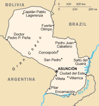
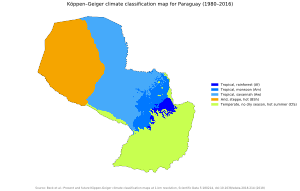
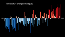
Paraguay is a country in South America, bordering Argentina, Bolivia and Brazil. The Paraguay River divides the country into strikingly different eastern and western regions. Both the eastern region and the western region gently slope toward and are drained into the Paraguay River, which separates and unifies the two regions. With the Paraneña region reaching southward and the Chaco extending to the north, Paraguay straddles the Tropic of Capricorn and experiences both subtropical and tropical climates.

<span class="mw-page-title-main">Geography of Tunisia</span>

Tunisia is a country in Northern Africa, bordering the Mediterranean Sea, having a western border with Algeria (965 km) and south-eastern border with Libya (459 km) where the width of land tapers to the south-west into the Sahara. The country has north, east and complex east-to-north coasts including the curved Gulf of Gabès, which forms the western part of Africa's Gulf of Sidra. Most of this greater gulf forms the main coast of Libya including the city of Sirte which shares its root name. The country's geographic coordinates are 34°00′N9°00′E. Tunisia occupies an area of 163,610 square kilometres, of which 8,250 are water. The principal and reliable rivers rise in the north of the country with a few notable exceptions from north-east Algeria and flow through the northern plain where sufficient rainfall supports diverse plant cover and irrigated agriculture.

<span class="mw-page-title-main">Climate of Missouri</span> Overview of the climate of Missouri, United States

Missouri generally has a variety of seasonal humid subtropical climate, with cool winters and long, hot summers. In the southern part of the state, particularly in the Bootheel, the climate borders on a more mild-type humid subtropical climate, and in the northern third, the state transitions into a humid continental climate. Because of its location in the interior United States, Missouri often experiences extremes in temperatures. Lacking either large mountains or oceans nearby to moderate its temperature, its climate is alternately influenced by air from the cold Arctic and the hot and humid Gulf of Mexico.

<span class="mw-page-title-main">Formosa, Argentina</span> City in Formosa, Argentina

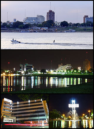
Formosa is the capital city of the Argentine province of Formosa, on the banks of the Paraguay River, opposite the Paraguayan town of Alberdi, about 1,200 km (746 mi) north from Buenos Aires, on National Route 11. The city has a population of about 234,000 per the 2010 census [INDEC].

<span class="mw-page-title-main">Resistencia, Chaco</span> City in Chaco, Argentina

Resistencia is the capital and largest city of the province of Chaco in north-eastern Argentina. According to the 2010 census, the population of the city proper was 291,720 inhabitants. It is the anchor of a larger metropolitan area, Greater Resistencia, which comprises at least three more municipalities for a total population of 387,340 as of 2010. This conurbation is the largest in the province, and the eleventh most populous in the country. It is located along the Negro River, a tributary of the much larger Paraná River, opposite the city of Corrientes, Corrientes Province.

<span class="mw-page-title-main">Corrientes</span> City in Argentina

Corrientes is the capital city of the province of Corrientes, Argentina, located on the eastern shore of the Paraná River, about 1,000 km (621 mi) from Buenos Aires and 300 km (186 mi) from Posadas, on National Route 12. It has a population of 346,334 according to the 2010 Census. It lies opposite its twin city, Resistencia, Chaco.

<span class="mw-page-title-main">Concepción, Paraguay</span> City and district in Concepción, Paraguay

Concepción is a city and district in northern Paraguay and capital of the Concepción Department. It lies next to the Paraguay River.

<span class="mw-page-title-main">Climate of Virginia</span> Overview of the climate of the U.S. state of Virginia

The climate of Virginia, a state on the east coast of the United States, is mild compared to more northern areas of the United States such as New England and the Midwest. Most of Virginia east of the Blue Ridge mountains, the southern part of the Shenandoah Valley, and the Roanoke Valley, has a humid subtropical climate. In the mountainous areas west of the Blue Ridge, the climate is warm-summer humid continental or oceanic climate. Severe weather, in the form of tornadoes, tropical cyclones, and winter storms, impacts the state on a regular basis. Central Virginia received significant snowfall of 20 inches in December 2009.

<span class="mw-page-title-main">Encarnación, Paraguay</span> District and city in Itapúa, Paraguay

Encarnación is a district and the capital city of Itapúa Department in Paraguay, located at the south-east of the department, on the right-hand (western) shore of the Paraná River, opposite Posadas, Argentina. The city has an area of 274 km2 and a population of 93,497, and the Greater Encarnacion area has a population of over 225,000 according to a 2020 estimate. Encarnación is the third-largest city of Paraguay. The city was originally named Nuestra Señora de la Anunciación de Itapúa, and is considered the capital of summer by most of its inhabitants.

<span class="mw-page-title-main">Pilar, Paraguay</span> City in Ñeembucú, Paraguay

Pilar is the capital city of the Paraguayan department of Ñeembucú, located along the Paraguay River in the southwestern part of the country. Located about 258 km (160 mi) from Asunción, Pilar serves as an important center of commerce and government for the far southwestern region of the country.

<span class="mw-page-title-main">Puerto Casado</span> Place in Alto Paraguay, Paraguay

Puerto Casado is one of the 4 districts in Alto Paraguay Department, Paraguay. It includes the town of La Victoria or Puerto La Victoria, which has a population of around 7,800.

<span class="mw-page-title-main">Mariscal Estigarribia</span> Town in Boquerón, Paraguay

Mariscal Estigarribia is a town in the Boquerón Department, Paraguay.

<span class="mw-page-title-main">Climate of California</span> Overview of the climate of the U.S. state of California

The climate of California varies widely from hot desert to alpine tundra, depending on latitude, elevation, and proximity to the Pacific Coast. California's coastal regions, the Sierra Nevada foothills, and much of the Central Valley have a Mediterranean climate, with warmer, drier weather in summer and cooler, wetter weather in winter. The influence of the ocean generally moderates temperature extremes, creating warmer winters and substantially cooler summers in coastal areas.

<span class="mw-page-title-main">Climate of Romania</span>

The climate of Romania is continental, transitioning into humid subtropical on the eastern coast, influenced by polar intrusions, and therefore characterized by harsh winters. The mountain ranges of the Carpathian arc have a cool mountain climate with high humidity throughout the year.

<span class="mw-page-title-main">Climate of Pennsylvania</span> Overview of the climate of the U.S. state of Pennsylvania

The climate of Pennsylvania is diverse due to the multitude of geographic features found within the state. Straddling two major climate zones, the southeastern corner of Pennsylvania has the warmest climate. A portion of Greater Philadelphia lies at the southernmost tip of the humid continental climate zone, with the city proper being in the humid subtropical climate zone. Still, Philadelphia features colder, snowier winters than most locations with a humid subtropical climate. Moving west toward the mountainous interior of the state, the climate becomes markedly colder, the number of cloudy days increases, and winter snowfall amounts are greater.

Rivadavia is a town in eastern Salta Province, Argentina in the Department of Rivadavia, 87 kilometres (54 mi) from the city of Salta. It is in a low-lying region of the province.

<span class="mw-page-title-main">Climate of Argentina</span> Climate of the country

The climate of Argentina varies from region to region, as the vast size of the country and wide variation in altitude make for a wide range of climate types. Summers are the warmest and wettest season in most of Argentina except in most of Patagonia where it is the driest season. Warm in the north, cool in the center and cold in the southern parts experiencing frequent frost and snow. Because southern parts of the country are moderated by the surrounding oceans, the cold is less intense and prolonged than areas at similar latitudes in the northern hemisphere. Spring and autumn are transition seasons that generally feature mild weather.

<span class="mw-page-title-main">Climate of Hungary</span> Overview of the climate of Hungary

The climate of Hungary is characterized by its position. Hungary is in the eastern part of Central Europe, roughly equidistant from the Equator and the North Pole, more than 1,000 kilometres (600 mi) from both and about 1,000 kilometers from the Atlantic Ocean.

Las Lomitas is a city in northern Argentina. It is located in the Patiño Department in the center of Formosa Province. It has a population of 12,399 inhabitants as of the 2010 census [INDEC]. This represented a 20% increase in the population compared to the 2001 census [INDEC] which only had 10,354 inhabitants.

References

  1. "World Weather Information Service – Asuncion". World Meteorological Organization. Archived from the original on October 27, 2012. Retrieved November 8, 2012.
  2. "ASUNCION Climate Normals 1961–1990". National Oceanic and Atmospheric Administration . Retrieved November 8, 2012.[ permanent dead link ]
  3. "Paraguay – Asuncion (pg 208)" (PDF). Climate Data for Selected Stations (1931–1960) (in Danish). Danish Meteorological Institute. Archived from the original (PDF) on January 16, 2013. Retrieved December 18, 2012.
  4. "Ciudad del Este Climate Normals 1961–1990". National Oceanic and Atmospheric Administration . Retrieved January 23, 2015.
  5. "86246: Aeropuerto Int. Guarani (Paraguay)". ogimet.com. OGIMET. 28 December 2021. Retrieved 1 January 2022.
  6. "Encarnación Climate Normals 1961–1990". National Oceanic and Atmospheric Administration . Retrieved March 9, 2015.
  7. "Klimatafel von Encarnación / Rio Paraná, Dep. Itapuá / Paraguay" (PDF). Baseline climate means (1961–1990) from stations all over the world (in German). Deutscher Wetterdienst. Retrieved February 14, 2016.
  8. "Concepción Climate Normals 1961–1990". National Oceanic and Atmospheric Administration . Retrieved March 9, 2015.
  9. "Station Concepción" (in French). Meteo Climat. Retrieved 15 June 2016.
  10. "Station 86134: Concepción". Global station data 1961–1990—Sunshine Duration. Deutscher Wetterdienst. Archived from the original on 2017-10-17. Retrieved 1 May 2015.
  11. "86134: Concepcion (Paraguay)". ogimet.com. OGIMET. 24 January 2022. Retrieved 24 January 2022.
  12. "Pilar Climate Normals 1961–1990". National Oceanic and Atmospheric Administration . Retrieved March 9, 2015.
  13. "86255: Pilar (Paraguay)". ogimet.com. OGIMET. 17 January 2022. Retrieved 20 January 2022.