Prevailing winds

Last updated
Winds are part of Earth's atmospheric circulation. Earth Global Circulation - en.svg
Winds are part of Earth's atmospheric circulation.
The westerlies (blue) and trade winds (yellow and brown) Map prevailing winds on earth.png
The westerlies (blue) and trade winds (yellow and brown)
Global surface wind vector flow lines colored by wind speed from June 1, 2011 to October 31, 2011.

In meteorology, prevailing wind in a region of the Earth's surface is a surface wind that blows predominantly from a particular direction. The dominant winds are the trends in direction of wind with the highest speed over a particular point on the Earth's surface at any given time. A region's prevailing and dominant winds are the result of global patterns of movement in the Earth's atmosphere. [1] In general, winds are predominantly easterly at low latitudes globally. In the mid-latitudes, westerly winds are dominant, and their strength is largely determined by the polar cyclone. In areas where winds tend to be light, the sea breeze/land breeze cycle is the most important cause of the prevailing wind; in areas which have variable terrain, mountain and valley breezes dominate the wind pattern. Highly elevated surfaces can induce a thermal low, which then augments the environmental wind flow.

Contents

Wind roses are tools used to display the direction of the prevailing wind. Knowledge of the prevailing wind allows the development of prevention strategies for wind erosion of agricultural land, such as across the Great Plains. Sand dunes can orient themselves perpendicular to the prevailing wind direction in coastal and desert locations. Insects drift along with the prevailing wind, but the flight of birds is less dependent on it. Prevailing winds in mountain locations can lead to significant rainfall gradients, ranging from wet across windward-facing slopes to desert-like conditions along their lee slopes. Prevailing winds can vary due to the uneven heating of the Earth.[ clarification needed ]

Wind rose

Wind rose plot for Fresno Air Terminal (FAT), Fresno, California for the month of April 1961 Wind rose plot.png
Wind rose plot for Fresno Air Terminal (FAT), Fresno, California for the month of April 1961

A wind rose is a graphic tool used by meteorologists to give a succinct view of how wind speed and direction are typically distributed at a particular location. Presented in a polar coordinate grid, the wind rose shows the frequency of winds blowing from particular directions. The length of each spoke around the circle is related to the proportion of the time that the wind blows from each direction. Each concentric circle represents a different proportion, increasing outwards from zero at the center. A wind rose plot may contain additional information, in that each spoke is broken down into color-coded bands that show wind speed ranges. Wind roses typically show 8 or 16 cardinal directions, such as north (N), NNE, NE, etc., [2] although they may be subdivided into as many as 32 directions. [3]

Climatology

Trades and their impact

The trade winds (also called trades) are the prevailing pattern of easterly surface winds found in the tropics near the Earth's equator, [4] equatorward of the subtropical ridge. These winds blow predominantly from the northeast in the Northern Hemisphere and from the southeast in the Southern Hemisphere. [5] The trade winds act as the steering flow for tropical cyclones that form over world's oceans, guiding their path westward. [6] Trade winds also steer African dust westward across the Atlantic Ocean into the Caribbean Sea, as well as portions of southeast North America. [7]

Westerlies and their impact

The westerlies or the prevailing westerlies are the prevailing winds in the middle latitudes (i.e. between 35 and 65 degrees latitude), which blow in areas poleward of the high pressure area known as the subtropical ridge in the horse latitudes. [8] [9] These prevailing winds blow from the west to the east, [10] and steer extra-tropical cyclones in this general direction. The winds are predominantly from the southwest in the Northern Hemisphere and from the northwest in the Southern Hemisphere. [5] They are strongest in the winter when the pressure is lower over the poles, such as when the polar cyclone is strongest, and weakest during the summer when the polar cyclone is weakest and when pressures are higher over the poles. [11]

Together with the trade winds, the westerlies enabled a round-trip trade route for sailing ships crossing the Atlantic and Pacific oceans, as the westerlies lead to the development of strong ocean currents in both hemispheres. The westerlies can be particularly strong, especially in the southern hemisphere, where there is less land in the middle latitudes to cause the flow pattern to amplify, which slows the winds down. The strongest westerly winds in the middle latitudes are called the Roaring Forties, between 40 and 50 degrees south latitude, within the Southern Hemisphere. [12] The westerlies play an important role in carrying the warm, equatorial waters and winds to the western coasts of continents, [13] [14] especially in the southern hemisphere because of its vast oceanic expanse.

The westerlies explain why coastal Western North America tends to be wet, especially from Northern Washington to Alaska, during the winter. Differential heating from the Sun between the land which is quite cool and the ocean which is relatively warm causes areas of low pressure to develop over land. This results in moisture-rich air flowing east from the Pacific Ocean, causing frequent rainstorms and wind on the coast. This moisture continues to flow eastward until orographic lift caused by the Coast Ranges, and the Cascade, Sierra Nevada, Columbia, and Rocky Mountains causes a rain shadow effect which limits further penetration of these systems and associated rainfall eastward. This trend reverses in the summer when strong heating of the land causes high pressure and tends to block moisture-rich air from the Pacific from reaching land. This explains why most of coastal Western North America in the highest latitude experiences dry summers, despite vast rainfall in the winter. [8] [9]

Polar easterlies

The polar easterlies (also known as Polar Hadley cells) are the dry, cold prevailing winds that blow from the high-pressure areas of the polar highs at the North and South Poles towards the low-pressure areas within the westerlies at high latitudes. Like trade winds and unlike the westerlies, these prevailing winds blow from the east to the west, and are often weak and irregular. [15] Due to the low sun angle, cold air builds up and subsides at the pole creating surface high-pressure areas, forcing an outflow of air toward the equator; [16] that outflow is deflected westward by the Coriolis effect.

Local considerations

Sea and land breezes

A: Sea breeze, B: Land breeze Diagrama de formacion de la brisa-breeze.svg
A: Sea breeze, B: Land breeze

In areas where the wind flow is light, sea breezes and land breezes are important factors in a location's prevailing winds. The sea is warmed by the sun to a greater depth than the land due to its greater specific heat. [17] The sea therefore has a greater capacity for absorbing heat than the land, so the surface of the sea warms up more slowly than the land's surface. As the temperature of the surface of the land rises, the land heats the air above it. The warm air is less dense and so it rises. This rising air over the land lowers the sea level pressure by about 0.2%. The cooler air above the sea, now with higher sea level pressure, flows towards the land into the lower pressure, creating a cooler breeze near the coast.

The strength of the sea breeze is directly proportional to the temperature difference between the land mass and the sea. If an off-shore wind of 8 knots (15 km/h) exists, the sea breeze is not likely to develop. At night, the land cools off more quickly than the ocean due to differences in their specific heat values, which forces the daytime sea breeze to dissipate. If the temperature onshore cools below the temperature offshore, the pressure over the water will be lower than that of the land, establishing a land breeze, as long as an onshore wind is not strong enough to oppose it. [18]

Circulation in elevated regions

Mountain wave schematic. The wind flows towards a mountain and produces a first oscillation (A). A second wave occurs further away and higher. The lenticular clouds form at the peak of the waves (B). Vol d'onde.svg
Mountain wave schematic. The wind flows towards a mountain and produces a first oscillation (A). A second wave occurs further away and higher. The lenticular clouds form at the peak of the waves (B).

Over elevated surfaces, heating of the ground exceeds the heating of the surrounding air at the same altitude above sea level, creating an associated thermal low over the terrain and enhancing any lows which would have otherwise existed, [19] [20] and changing the wind circulation of the region. In areas where there is rugged topography that significantly interrupts the environmental wind flow, the wind can change direction and accelerate parallel to the wind obstruction. This barrier jet can increase the low level wind by 45%. [21] In mountainous areas, local distortion of the airflow is more severe. Jagged terrain combines to produce unpredictable flow patterns and turbulence, such as rotors. Strong updrafts, downdrafts and eddies develop as the air flows over hills and down valleys. Wind direction changes due to the contour of the land. If there is a pass in the mountain range, winds will rush through the pass with considerable speed due to the Bernoulli principle that describes an inverse relationship between speed and pressure. The airflow can remain turbulent and erratic for some distance downwind into the flatter countryside. These conditions are dangerous to ascending and descending airplanes. [22]

Daytime heating and nighttime cooling of the hilly slopes lead to day to night variations in the airflow, similar to the relationship between sea breeze and land breeze. At night, the sides of the hills cool through radiation of the heat. The air along the hills becomes cooler and denser, blowing down into the valley, drawn by gravity. This is known a mountain breeze. If the slopes are covered with ice and snow, the mountain breeze will blow during the day, carrying the cold dense air into the warmer, barren valleys. The slopes of hills not covered by snow will be warmed during the day. The air that comes in contact with the warmed slopes becomes warmer and less dense and flows uphill. This is known as an anabatic wind or valley breeze. [23]

Effect on precipitation

Orographic precipitation Steigungsregen.jpg
Orographic precipitation

Orographic precipitation occurs on the windward side of mountains and is caused by the rising air motion of a large-scale flow of moist air across the mountain ridge, resulting in adiabatic cooling and condensation. In mountainous parts of the world subjected to consistent winds (for example, the trade winds), a more moist climate usually prevails on the windward side of a mountain than on the leeward or downwind side. Moisture is removed by orographic lift, leaving drier air (see foehn wind) on the descending and generally warming, leeward side where a rain shadow is observed. [24]

In South America, the Andes mountain range blocks Pacific moisture that arrives in that continent, resulting in a desertlike climate just downwind across western Argentina. [25] The Sierra Nevada range creates the same effect in North America forming the Great Basin and Mojave Deserts. [26] [27]

Effect on nature

Sand blowing off a crest in the Kelso Dunes of the Mojave Desert, California. KelsoSand.JPG
Sand blowing off a crest in the Kelso Dunes of the Mojave Desert, California.

Insects are swept along by the prevailing winds, while birds follow their own course. [28] As such, fine line patterns within weather radar imagery, associated with converging winds, are dominated by insect returns. [29] In the Great Plains, wind erosion of agricultural land is a significant problem, and is mainly driven by the prevailing wind. Because of this, wind barrier strips have been developed to minimize this type of erosion. The strips can be in the form of soil ridges, crop strips, crops rows, or trees which act as wind breaks. They are oriented perpendicular to the wind in order to be most effective. [30] In regions with minimal vegetation, such as coastal and desert areas, transverse sand dunes orient themselves perpendicular to the prevailing wind direction, while longitudinal dunes orient themselves parallel to the prevailing winds. [31]

See also

Related Research Articles

<span class="mw-page-title-main">Cyclone</span> Large scale air mass that rotates around a strong center of low pressure

In meteorology, a cyclone is a large air mass that rotates around a strong center of low atmospheric pressure, counterclockwise in the Northern Hemisphere and clockwise in the Southern Hemisphere as viewed from above. Cyclones are characterized by inward-spiraling winds that rotate about a zone of low pressure. The largest low-pressure systems are polar vortices and extratropical cyclones of the largest scale. Warm-core cyclones such as tropical cyclones and subtropical cyclones also lie within the synoptic scale. Mesocyclones, tornadoes, and dust devils lie within the smaller mesoscale.

<span class="mw-page-title-main">Monsoon</span> Seasonal changes in atmospheric circulation and precipitation

A monsoon is traditionally a seasonal reversing wind accompanied by corresponding changes in precipitation but is now used to describe seasonal changes in atmospheric circulation and precipitation associated with annual latitudinal oscillation of the Intertropical Convergence Zone (ITCZ) between its limits to the north and south of the equator. Usually, the term monsoon is used to refer to the rainy phase of a seasonally changing pattern, although technically there is also a dry phase. The term is also sometimes used to describe locally heavy but short-term rains.

<span class="mw-page-title-main">Anticyclone</span> Weather phenomenon of high pressure, as opposed to a cyclone

An anticyclone is a weather phenomenon defined as a large-scale circulation of winds around a central region of high atmospheric pressure, clockwise in the Northern Hemisphere and counterclockwise in the Southern Hemisphere as viewed from above. Effects of surface-based anticyclones include clearing skies as well as cooler, drier air. Fog can also form overnight within a region of higher pressure.

<span class="mw-page-title-main">Air mass</span> Volume of air defined by its temperature and water vapor content

In meteorology, an air mass is a volume of air defined by its temperature and humidity. Air masses cover many hundreds or thousands of square miles, and adapt to the characteristics of the surface below them. They are classified according to latitude and their continental or maritime source regions. Colder air masses are termed polar or arctic, while warmer air masses are deemed tropical. Continental and superior air masses are dry, while maritime and monsoon air masses are moist. Weather fronts separate air masses with different density characteristics. Once an air mass moves away from its source region, underlying vegetation and water bodies can quickly modify its character. Classification schemes tackle an air mass's characteristics, as well as modification.

<span class="mw-page-title-main">Physical oceanography</span> Study of physical conditions and processes within the ocean

Physical oceanography is the study of physical conditions and physical processes within the ocean, especially the motions and physical properties of ocean waters.

<span class="mw-page-title-main">Rain shadow</span> Leeward side of a mountain range

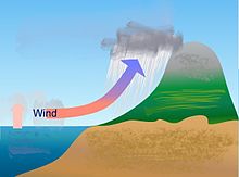
A rain shadow is an area of significantly reduced rainfall behind a mountainous region, on the side facing away from prevailing winds, known as its leeward side.

<span class="mw-page-title-main">Atmospheric circulation</span> Process which distributes thermal energy about the Earths surface

Atmospheric circulation is the large-scale movement of air and together with ocean circulation is the means by which thermal energy is redistributed on the surface of the Earth. The Earth's atmospheric circulation varies from year to year, but the large-scale structure of its circulation remains fairly constant. The smaller-scale weather systems – mid-latitude depressions, or tropical convective cells – occur chaotically, and long-range weather predictions of those cannot be made beyond ten days in practice, or a month in theory.

<span class="mw-page-title-main">Sea breeze</span> Wind blowing from sea to land

A sea breeze or onshore breeze is any wind that blows from a large body of water toward or onto a landmass. By contrast, a land breeze or offshore breeze is any wind that blows from a landmass toward or onto a large body of water. The term offshore wind may refer to any wind over open water. Sea breezes and land breezes are both important factors in coastal regions' prevailing winds.

<span class="mw-page-title-main">High-pressure area</span> Region with higher atmospheric pressure

A high-pressure area, high, or anticyclone, is an area near the surface of a planet where the atmospheric pressure is greater than the pressure in the surrounding regions. Highs are middle-scale meteorological features that result from interplays between the relatively larger-scale dynamics of an entire planet's atmospheric circulation.

<span class="mw-page-title-main">Low-pressure area</span> Area with air pressures lower than adjacent areas

In meteorology, a low-pressure area, low area or low is a region where the atmospheric pressure is lower than that of surrounding locations. Low-pressure areas are commonly associated with inclement weather, while high-pressure areas are associated with lighter winds and clear skies. Winds circle anti-clockwise around lows in the northern hemisphere, and clockwise in the southern hemisphere, due to opposing Coriolis forces. Low-pressure systems form under areas of wind divergence that occur in the upper levels of the atmosphere (aloft). The formation process of a low-pressure area is known as cyclogenesis. In meteorology, atmospheric divergence aloft occurs in two kinds of places:

<span class="mw-page-title-main">Trade winds</span> Equatorial east-to-west prevailing winds

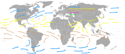
The trade winds or easterlies are permanent east-to-west prevailing winds that flow in the Earth's equatorial region. The trade winds blow mainly from the northeast in the Northern Hemisphere and from the southeast in the Southern Hemisphere, strengthening during the winter and when the Arctic oscillation is in its warm phase. Trade winds have been used by captains of sailing ships to cross the world's oceans for centuries. They enabled European colonization of the Americas, and trade routes to become established across the Atlantic Ocean and the Pacific Ocean.

<span class="mw-page-title-main">Westerlies</span> Prevailing winds from the west

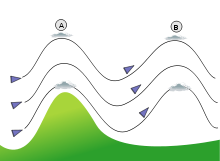
The westerlies, anti-trades, or prevailing westerlies, are prevailing winds from the west toward the east in the middle latitudes between 30 and 60 degrees latitude. They originate from the high-pressure areas in the horse latitudes and trend towards the poles and steer extratropical cyclones in this general manner. Tropical cyclones which cross the subtropical ridge axis into the westerlies recurve due to the increased westerly flow. The winds are predominantly from the southwest in the Northern Hemisphere and from the northwest in the Southern Hemisphere.

In the study of Earth's atmosphere, polar easterlies are the dry, cold prevailing winds that blow around the high-pressure areas of the polar highs at the North and South Poles. Cold air subsides at the poles creating high pressure zones, forcing an equatorward outflow of air; that outflow is then deflected westward by the Coriolis effect. Unlike the westerlies in the middle latitudes and trade winds in tropics, the polar easterlies are often weak and irregular. Note, winds are named based on where they came from. The polar easterlies are one of the five primary wind zones, known as wind belts, that make up our atmosphere's circulatory system. This particular belt of wind begins at approximately 60 degrees north and south latitude and reaches to the poles.

<span class="mw-page-title-main">Pressure system</span> Relative peak or lull in the sea level pressure distribution

A pressure system is a peak or lull in the sea level pressure distribution. The surface pressure at sea level varies minimally, with the lowest value measured 87 kilopascals (26 inHg) and the highest recorded 108.57 kilopascals (32.06 inHg). High- and low-pressure systems evolve due to interactions of temperature differentials in the atmosphere, temperature differences between the atmosphere and water within oceans and lakes, the influence of upper-level disturbances, as well as the amount of solar heating or radiationized cooling an area receives. Pressure systems cause weather to be experienced locally. Low-pressure systems are associated with clouds and precipitation that minimize temperature changes throughout the day, whereas high-pressure systems normally associate with dry weather and mostly clear skies with larger diurnal temperature changes due to greater radiation at night and greater sunshine during the day. Pressure systems are analyzed by those in the field of meteorology within surface weather maps.

<span class="mw-page-title-main">Convergence zone</span> Region in the atmosphere

A convergence zone in meteorology is a region in the atmosphere where two prevailing flows meet and interact, usually resulting in distinctive weather conditions. This causes a mass accumulation that eventually leads to a vertical movement and to the formation of clouds and precipitation. Large-scale convergence, called synoptic-scale convergence, is associated with weather systems such as baroclinic troughs, low-pressure areas, and cyclones. The large-scale convergence zone formed over the equator, the Intertropical Convergence Zone, has condensed and intensified as a result of the global increase in temperature. Small-scale convergence will give phenomena from isolated cumulus clouds to large areas of thunderstorms.

<span class="mw-page-title-main">Wind</span> Natural movement of air or other gases relative to a planets surface

Wind is the natural movement of air or other gases relative to a planet's surface. Winds occur on a range of scales, from thunderstorm flows lasting tens of minutes, to local breezes generated by heating of land surfaces and lasting a few hours, to global winds resulting from the difference in absorption of solar energy between the climate zones on Earth. The two main causes of large-scale atmospheric circulation are the differential heating between the equator and the poles, and the rotation of the planet. Within the tropics and subtropics, thermal low circulations over terrain and high plateaus can drive monsoon circulations. In coastal areas the sea breeze/land breeze cycle can define local winds; in areas that have variable terrain, mountain and valley breezes can prevail.

<span class="mw-page-title-main">Thermal low</span> Are non-weather fronts, a low-pressure areas that occur over the continents in the subtropics

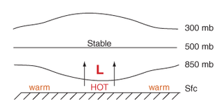
Thermal lows, or heat lows, are non-frontal low-pressure areas that occur over the continents in the subtropics during the warm season, as the result of intense heating when compared to their surrounding environments. Thermal lows occur near the Sonoran Desert, on the Mexican plateau, in California's Great Central Valley, in the Sahara, in the Kalahari, over north-west Argentina, in South America, over the Kimberley region of north-west Australia, over the Iberian peninsula, and over the Tibetan plateau.

<span class="mw-page-title-main">Monsoon of South Asia</span> Monsoon in Indian subcontinent

The Monsoon of South Asia is among several geographically distributed global monsoons. It affects the Indian subcontinent, where it is one of the oldest and most anticipated weather phenomena and an economically important pattern every year from June through September, but it is only partly understood and notoriously difficult to predict. Several theories have been proposed to explain the origin, process, strength, variability, distribution, and general vagaries of the monsoon, but understanding and predictability are still evolving.

<span class="mw-page-title-main">Glossary of meteorology</span> List of definitions of terms and concepts commonly used in meteorology

This glossary of meteorology is a list of terms and concepts relevant to meteorology and atmospheric science, their sub-disciplines, and related fields.

A Wind generated current is a flow in a body of water that is generated by wind friction on its surface. Wind can generate surface currents on water bodies of any size. The depth and strength of the current depend on the wind strength and duration, and on friction and viscosity losses, but are limited to about 400 m depth by the mechanism, and to lesser depths where the water is shallower. The direction of flow is influenced by the Coriolis effect, and is offset to the right of the wind direction in the Northern Hemisphere, and to the left in the Southern Hemisphere. A wind current can induce secondary water flow in the form of upwelling and downwelling, geostrophic flow, and western boundary currents.

References

  1. URS (2008). Section 3.2 Climate conditions (in Spanish). Estudio de Impacto Ambiental Subterráneo de Gas Natural Castor. Retrieved on 2009-04-26.
  2. Glossary of Meteorology (2009). Wind rose. Archived 2012-03-15 at the Wayback Machine American Meteorological Society. Retrieved on 2009-04-25.
  3. Jan Curtis (2007). Wind Rose Data. Natural Resources Conservation Service. Retrieved on 2009-04-26.
  4. Glossary of Meteorology (2009). "trade winds". Glossary of Meteorology. American Meteorological Society. Retrieved 4 July 2021.
  5. 1 2 Ralph Stockman Tarr; Frank Morton McMurry; Almon Ernest Parkins (1909). Advanced geography. Macmillan. pp.  246–.
  6. Joint Typhoon Warning Center (2006). 3.3 JTWC Forecasting Philosophies. United States Navy. Retrieved on 2007-02-11.
  7. Science Daily (1999-07-14). African Dust Called A Major Factor Affecting Southeast U.S. Air Quality. Retrieved on 2007-06-10.
  8. 1 2 Glossary of Meteorology (2009). "Westerlies". American Meteorological Society. Archived from the original on 2010-06-22. Retrieved 2009-04-15.
  9. 1 2 Sue Ferguson (2001-09-07). "Climatology of the Interior Columbia River Basin" (PDF). Interior Columbia Basin Ecosystem Management Project. Archived from the original (PDF) on 2009-05-15. Retrieved 2009-09-12.
  10. Glossary of Meteorology (2009). Westerlies. Archived 2010-06-22 at the Wayback Machine American Meteorological Society. Retrieved on 2009-04-15.
  11. Halldór Björnsson (2005). Global circulation. Archived 2011-08-07 at the Wayback Machine Veðurstofu Íslands. Retrieved on 2008-06-15.
  12. Walker, Stuart (1998). The sailor's wind . W. W. Norton & Company. p.  91. ISBN   9780393045550. Roaring Forties Shrieking Sixties westerlies.
  13. Barbie Bischof; Arthur J. Mariano; Edward H. Ryan (2003). "The North Atlantic Drift Current". The National Oceanographic Partnership Program . Retrieved 2008-09-10.
  14. Erik A. Rasmussen; John Turner (2003). Polar Lows. Cambridge University Press. p. 68.
  15. Glossary of Meteorology (2009). Polar easterlies. Archived 2012-07-12 at the Wayback Machine American Meteorological Society. Retrieved on 2009-04-15.
  16. Michael E. Ritter (2008). The Physical Environment: Global scale circulation. Archived 2009-05-06 at the Wayback Machine University of Wisconsin-Stevens Point. Retrieved on 2009-04-15.
  17. Dr. Steve Ackerman (1995). Sea and Land Breezes. University of Wisconsin. Retrieved on 2006-10-24.
  18. JetStream: An Online School For Weather (2008). The Sea Breeze. Archived 2006-09-23 at the Wayback Machine National Weather Service. Retrieved on 2006-10-24.
  19. National Weather Service Office in Tucson, Arizona (2008). What is a monsoon? National Weather Service Western Region Headquarters. Retrieved on 2009-03-08.
  20. Hahn, Douglas G.; Manabe, Syukuro (1975). "The Role of Mountains in the South Asian Monsoon Circulation". Journal of the Atmospheric Sciences. 32 (8): 1515–1541. Bibcode:1975JAtS...32.1515H. doi: 10.1175/1520-0469(1975)032<1515:TROMIT>2.0.CO;2 .
  21. Doyle, J. D. (1997). "The influence of mesoscale orography on a coastal jet and rainband". Monthly Weather Review. 125 (7): 1465–1488. Bibcode:1997MWRv..125.1465D. doi: 10.1175/1520-0493(1997)125<1465:TIOMOO>2.0.CO;2 . ISSN   0027-0644.
  22. National Center for Atmospheric Research (2006). T-REX: Catching the Sierra’s waves and rotors Archived 2009-02-21 at the Wayback Machine Retrieved on 2006-10-21.
  23. ALLSTAR Network (2009). Flight Environment: Prevailing winds. Florida International University. Retrieved on 2009-04-25.
  24. Dr. Michael Pidwirny (2008). CHAPTER 8: Introduction to the Hydrosphere (e). Cloud Formation Processes. Physical Geography. Retrieved on 2009-01-01.
  25. Paul E. Lydolph (1985). The Climate of the Earth. Rowman & Littlefield, p. 333. ISBN   978-0-86598-119-5. Retrieved on 2009-01-02.
  26. Michael A. Mares (1999). Encyclopedia of Deserts. University of Oklahoma Press, p. 252. ISBN   978-0-8061-3146-7. Retrieved on 2009-01-02.
  27. Adam Ganson (2003). Geology of Death Valley. Indiana University. Retrieved on 2009-02-07.
  28. Diana Yates (2008). Birds migrate together at night in dispersed flocks, new study indicates. University of Illinois at Urbana  Champaign. Retrieved on 2009-04-26.
  29. Bart Geerts and Dave Leon (2003). P5A.6 Fine-Scale Vertical Structure of a Cold Front As Revealed By Airborne 95 GHZ Radar. University of Wyoming. Retrieved on 2009-04-26.
  30. W. S. Chepil, F. H. Siddoway and D. V. Armbrust (1964). In the Great Plains: Prevailing Wind Erosion Direction. Archived 2010-06-25 at the Wayback Machine Journal of Soil and Water Conservation, March–April 1964, p. 67. Retrieved on 2009-04-26.
  31. Ronald Greeley, James D. Iversen (1987). Wind as a geological process on Earth, Mars, Venus and Titan. CUP Archive, pp. 158162. ISBN   978-0-521-35962-7. Retrieved on 2009-04-26.