High-pressure area

Last updated

Satellite image showing a high-pressure area south of Australia, evidenced by the clearing in the clouds High Pressure.jpg
Satellite image showing a high-pressure area south of Australia, evidenced by the clearing in the clouds

A high-pressure area, high, or anticyclone, is an area near the surface of a planet where the atmospheric pressure is greater than the pressure in the surrounding regions. Highs are middle-scale meteorological features that result from interplays between the relatively larger-scale dynamics of an entire planet's atmospheric circulation.

Contents

The strongest high-pressure areas result from masses of cold air which spread out from polar regions into cool neighboring regions. These highs weaken once they extend out over warmer bodies of water.

Weaker—but more frequently occurring—are high-pressure areas caused by atmospheric subsidence: Air becomes cool enough to precipitate out its water vapor, and large masses of cooler, drier air descend from above.

Within high-pressure areas, winds flow from where the pressure is highest, at the center of the area, toward the periphery where the pressure is lower. However, if the planet is rotating, the straight direction of the air flow from the center to the periphery is bent by the Coriolis effect. Viewed from above, the wind direction is bent in the direction opposite to the planet's rotation; this causes the characteristic spiral shape of the tropical cyclones otherwise known as hurricanes and typhoons.

On English-language weather maps, high-pressure centers are identified by the letter H. Weather maps in other languages may use different letters or symbols.

Wind circulation in the northern and southern hemispheres

The direction of wind flow around an atmospheric high-pressure area and a low-pressure area, as seen from above, depends on the hemisphere. High-pressure systems rotate clockwise in the northern Hemisphere; low-pressure systems rotate clockwise in the southern hemisphere.

High pressure systems may be either warm or cold types, the former originating in the subtropics and the latter at high latitudes, the time of year dictating which type is more dominant. Humidity and temperature of the high pressure system will depend on its source of origin. Warm high pressure systems from the horse latitudes (see below) create typical summer heat waves while cold high pressure systems bring freezing spells in winter and cooler, lower humidity in summer. If a high sits over the same area for several days it will take on the characteristics of that terrain. Cold high pressure systems in the Northern Hemisphere originate from Siberia, interior Canada, or the north Atlantic or Pacific, the latter two types trailing behind cyclonic systems. In the Southern Hemisphere, which is mostly water, these originate principally from the southern oceans.

The latitudes of 30N and 30S have semi-permanent high pressure around them known as the subtropical ridge, although their size and exact location varies with the seasons. On the West Coast of the United States, the subtropical ridge expands in spring and brings the region's characteristic rainless summer weather. As it shrinks in fall, the West Coast is subject to cold fronts from the Pacific which bring rain during the cool months. On the East Coast, it brings warm, humid air in late spring and throughout summer. In fall, as the subtropical ridge retreats, cold air from Canada takes over. In Europe, the effect is similar as the subtropical ridge brings the Mediterranean hot, dry summer weather and cool, wet winters. Europe north of the Pyrenees is at a higher latitude so the effect of the ridge is somewhat less significant and this region is mainly characterized by a cooler maritime climate. However, a particularly hot summer such as 2003 or 2019 which sees the subtropical ridge expand more than usual can bring heat waves as far north as Scandinavia—conversely, while Europe had record-breaking summer heat in 2003 due to a particularly strong subtropical ridge, its counterpart in North America was unusually weak and temperatures across the continent that spring and summer were wet and well below normal. [2]

In the Southern Hemisphere the result is similar. Australia and the southern cone of South America get hot, dry summer weather from the subtropical ridge and cooler wetter winter weather as cold fronts from the southern oceans take over. [3]

Winter sees the dominance of cold highs from the sub-Arctic. In Western Europe and the West Coast of North America, these originate in the Gulf of Alaska or the Greenland/Iceland area and move south to southeast. Since they are principally masses of ocean air, they will bring cool, damp conditions with widespread fog. In East Asia and interior North America, these air masses come from Siberia or Canada and bring very cold, dry air in their wake.

The scientific terms in English used to describe the weather systems generated by highs and lows were introduced in the mid-19th century, mostly by the British. The scientific theories which explain the general phenomena originated about two centuries earlier.

The term cyclone was coined by Henry Piddington of the British East India Company to describe the devastating storm of December 1789 in Coringa, India. [4] A cyclone forms around a low-pressure area. Anticyclone, the term for the kind of weather around a high-pressure area, was coined in 1877 by Francis Galton [5] to indicate an area whose winds revolved in the opposite direction of a cyclone. In British English, the opposite direction of clockwise is referred to as anticlockwise, making the label anticyclones a logical extension.

A simple rule is that for high-pressure areas, where generally air flows from the center outward, the coriolis force given by the earth's rotation to the air circulation is in the opposite direction of earth's apparent rotation if viewed from above the hemisphere's pole. So, both the earth and winds around a low-pressure area rotate counter-clockwise in the northern hemisphere, and clockwise in the southern. The opposite to these two cases occurs in the case of a high. These results derive from the Coriolis effect; that article explains in detail the physics, and provides an animation of a model to aid understanding.

Formation

A surface weather analysis for the United States on 21 October 2006. Surface analysis.gif
A surface weather analysis for the United States on 21 October 2006.

High-pressure areas form due to downward motion through the troposphere, the atmospheric layer where weather occurs. Preferred areas within a synoptic flow pattern in higher levels of the troposphere are beneath the western side of troughs.

On weather maps, these areas show converging winds (isotachs), also known as convergence, near or above the level of non-divergence, which is near the 500 hPa pressure surface about midway up through the troposphere, and about half the atmospheric pressure at the surface. [6] [7]

High-pressure systems are alternatively referred to as anticyclones. On English-language weather maps, high-pressure centers are identified by the letter H in English, [8] within the isobar with the highest pressure value. On constant pressure upper level charts, it is located within the highest height line contour. [9]

Typical conditions

The subtropical ridge shows up as a large area of black (dryness) on this water vapor satellite image from September 2000 Subtropicalridge2000091412.jpg
The subtropical ridge shows up as a large area of black (dryness) on this water vapor satellite image from September 2000

Highs are frequently associated with light winds at the surface and subsidence through the lower portion of the troposphere. In general, subsidence will dry out an air mass by adiabatic, or compressional, heating. [10] Thus, high pressure typically brings clear skies. [11] During the day, since no clouds are present to reflect sunlight, there is more incoming shortwave solar radiation and temperatures rise. At night, the absence of clouds means that outgoing longwave radiation (i.e. heat energy from the surface) is not absorbed, giving cooler diurnal low temperatures in all seasons. When surface winds become light, the subsidence produced directly under a high-pressure system can lead to a buildup of particulates in urban areas under the ridge, leading to widespread haze. [12] If the low level relative humidity rises towards 100 percent overnight, fog can form. [13]

The letter H is used to represent a high-pressure area. High pressure symbol.svg
The letter H is used to represent a high-pressure area.

Strong, vertically shallow high-pressure systems moving from higher latitudes to lower latitudes in the northern hemisphere are associated with continental arctic air masses. [14] Once arctic air moves over an unfrozen ocean, the air mass modifies greatly over the warmer water and takes on the character of a maritime air mass, which reduces the strength of the high-pressure system. [15] When extremely cold air moves over relatively warm oceans, polar lows can develop. [16] However, warm and moist (or maritime tropical) air masses that move poleward from tropical sources are slower to modify than arctic air masses. [17]

In climatology

The Hadley cell carries heat and moisture from the tropics towards the northern and southern mid-latitudes. HadleyCross-sec.jpg
The Hadley cell carries heat and moisture from the tropics towards the northern and southern mid-latitudes.

The horse latitudes, or torrid zone, [18] is roughly at the 30th parallel and is the source of warm high pressure systems. As the hot air closer to the equator rises, it cools, losing moisture; it is then transported poleward where it descends, creating the high-pressure area. [19] This is part of the Hadley cell circulation and is known as the subtropical ridge or subtropical high. It follows the track of the sun over the year, expanding north (south in the Southern Hemisphere) in spring and retreating south (north in the Southern Hemisphere) in fall. [20] The subtropical ridge is a warm core high-pressure system, meaning it strengthens with height. [21] Many of the world's deserts are caused by these climatological high-pressure systems. [22]

Some climatological high-pressure areas acquire regionally based names. The land-based Siberian High often remains quasi-stationary for more than a month during the most frigid time of the year, making it unique in that regard. It is also a bit larger and more persistent than its counterpart in North America. [23] Surface winds accelerating down valleys down the western Pacific Ocean coastline, causing the winter monsoon. [24] Arctic high-pressure systems such as the Siberian High are cold core, meaning that they weaken with height. [21] The influence of the Azores High, also known as the Bermuda High, brings fair weather over much of the North Atlantic Ocean and mid to late summer heat waves in western Europe. [25] Along its southerly periphery, the clockwise circulation often impels easterly waves, and tropical cyclones that develop from them, across the ocean towards landmasses in the western portion of ocean basins during the hurricane season. [26] The highest barometric pressure ever recorded on Earth was 1,085.7 hectopascals (32.06 inHg) measured in Tosontsengel, Zavkhan, Mongolia on 19 December 2001. [27]

Connection to wind

Wind flows from areas of high pressure to areas of low pressure. [28] This is due to density differences between the two air masses. Since stronger high-pressure systems contain cooler or drier air, the air mass is more dense and flows towards areas that are warm or moist, which are in the vicinity of low pressure areas in advance of their associated cold fronts. The stronger the pressure difference, or pressure gradient, between a high-pressure system and a low-pressure system, the stronger the wind. The coriolis force caused by the Earth's rotation is what gives winds within high-pressure systems their clockwise circulation in the northern hemisphere (as the wind moves outward and is deflected right from the center of high pressure) and counterclockwise circulation in the southern hemisphere (as the wind moves outward and is deflected left from the center of high pressure). Friction with land slows down the wind flowing out of high-pressure systems and causes wind to flow more outward than would be the case in the absence of friction. This results in the 'actual wind' or 'true wind', including ageostrophic corrections, which add to the geostrophic wind that is characterized by flow parallel to the isobars. [29]

See also

Related Research Articles

<span class="mw-page-title-main">Jet stream</span> Fast-flowing atmospheric air current

Jet streams are fast flowing, narrow, meandering air currents in the atmospheres of the Earth, Venus, Jupiter, Saturn, Uranus, and Neptune. On Earth, the main jet streams are located near the altitude of the tropopause and are westerly winds. Jet streams may start, stop, split into two or more parts, combine into one stream, or flow in various directions including opposite to the direction of the remainder of the jet.

<span class="mw-page-title-main">Cyclone</span> Large scale air mass that rotates around a strong center of low pressure

In meteorology, a cyclone is a large air mass that rotates around a strong center of low atmospheric pressure, counterclockwise in the Northern Hemisphere and clockwise in the Southern Hemisphere as viewed from above. Cyclones are characterized by inward-spiraling winds that rotate about a zone of low pressure. The largest low-pressure systems are polar vortices and extratropical cyclones of the largest scale. Warm-core cyclones such as tropical cyclones and subtropical cyclones also lie within the synoptic scale. Mesocyclones, tornadoes, and dust devils lie within the smaller mesoscale.

<span class="mw-page-title-main">Surface weather analysis</span> Type of weather map

Surface weather analysis is a special type of weather map that provides a view of weather elements over a geographical area at a specified time based on information from ground-based weather stations.

<span class="mw-page-title-main">Horse latitudes</span> Latitudes 30–35 degrees north and south of the Equator

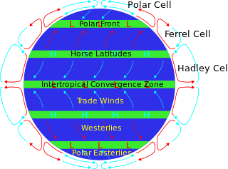
The horse latitudes are the latitudes about 30 degrees north and south of the Equator. They are characterized by sunny skies, calm winds, and very little precipitation. They are also known as subtropical ridges or highs. It is a high-pressure area at the divergence of trade winds and the westerlies.

<span class="mw-page-title-main">Anticyclone</span> Weather phenomenon of high pressure, as opposed to a cyclone

An anticyclone is a weather phenomenon defined as a large-scale circulation of winds around a central region of high atmospheric pressure, clockwise in the Northern Hemisphere and counterclockwise in the Southern Hemisphere as viewed from above. Effects of surface-based anticyclones include clearing skies as well as cooler, drier air. Fog can also form overnight within a region of higher pressure.

<span class="mw-page-title-main">Low-pressure area</span> Area with air pressures lower than adjacent areas

In meteorology, a low-pressure area, low area or low is a region where the atmospheric pressure is lower than that of surrounding locations. Low-pressure areas are commonly associated with inclement weather, while high-pressure areas are associated with lighter winds and clear skies. Winds circle anti-clockwise around lows in the northern hemisphere, and clockwise in the southern hemisphere, due to opposing Coriolis forces. Low-pressure systems form under areas of wind divergence that occur in the upper levels of the atmosphere (aloft). The formation process of a low-pressure area is known as cyclogenesis. In meteorology, atmospheric divergence aloft occurs in two kinds of places:

<span class="mw-page-title-main">Synoptic scale meteorology</span> 1000-km-order method of measuring weather systems

In meteorology, the synoptic scale is a horizontal length scale of the order of 1,000 km (620 mi) or more. This corresponds to a horizontal scale typical of mid-latitude depressions. Most high- and low-pressure areas seen on weather maps are synoptic-scale systems, driven by the location of Rossby waves in their respective hemisphere. Low-pressure areas and their related frontal zones occur on the leading edge of a trough within the Rossby wave pattern, while high-pressure areas form on the back edge of the trough. Most precipitation areas occur near frontal zones. The word synoptic is derived from the Ancient Greek word συνοπτικός (sunoptikós), meaning "seen together".

<span class="mw-page-title-main">Prevailing winds</span> Strongest direction of wind on a region of Earths surface

In meteorology, prevailing wind in a region of the Earth's surface is a surface wind that blows predominantly from a particular direction. The dominant winds are the trends in direction of wind with the highest speed over a particular point on the Earth's surface at any given time. A region's prevailing and dominant winds are the result of global patterns of movement in the Earth's atmosphere. In general, winds are predominantly easterly at low latitudes globally. In the mid-latitudes, westerly winds are dominant, and their strength is largely determined by the polar cyclone. In areas where winds tend to be light, the sea breeze/land breeze cycle is the most important cause of the prevailing wind; in areas which have variable terrain, mountain and valley breezes dominate the wind pattern. Highly elevated surfaces can induce a thermal low, which then augments the environmental wind flow.

<span class="mw-page-title-main">Westerlies</span> Prevailing winds from the west

The westerlies, anti-trades, or prevailing westerlies, are prevailing winds from the west toward the east in the middle latitudes between 30 and 60 degrees latitude. They originate from the high-pressure areas in the horse latitudes and trend towards the poles and steer extratropical cyclones in this general manner. Tropical cyclones which cross the subtropical ridge axis into the westerlies recurve due to the increased westerly flow. The winds are predominantly from the southwest in the Northern Hemisphere and from the northwest in the Southern Hemisphere.

<span class="mw-page-title-main">Pressure system</span> Relative peak or lull in the sea level pressure distribution

A pressure system is a peak or lull in the sea level pressure distribution. The surface pressure at sea level varies minimally, with the lowest value measured 87 kilopascals (26 inHg) and the highest recorded 108.57 kilopascals (32.06 inHg). High- and low-pressure systems evolve due to interactions of temperature differentials in the atmosphere, temperature differences between the atmosphere and water within oceans and lakes, the influence of upper-level disturbances, as well as the amount of solar heating or radiationized cooling an area receives. Pressure systems cause weather to be experienced locally. Low-pressure systems are associated with clouds and precipitation that minimize temperature changes throughout the day, whereas high-pressure systems normally associate with dry weather and mostly clear skies with larger diurnal temperature changes due to greater radiation at night and greater sunshine during the day. Pressure systems are analyzed by those in the field of meteorology within surface weather maps.

<span class="mw-page-title-main">Anticyclonic storm</span> Type of storm

An anticyclonic storm is a storm with a high-pressure center, in which winds flow in the direction opposite to that of the flow above a region of low pressure. Unlike a cyclonic storm, anticyclonic storms are typically associated with fair weather and stable atmospheric conditions. On other planets or in rare cases on Earth, anticyclones can contribute to inclement weather. Examples include Hartmut, which brought a blizzard to the British Isles in 2018, Jupiter, and Neptune's persistent anticyclonic storms.

<span class="mw-page-title-main">Mesoscale convective system</span> Complex of thunderstorms organized on a larger scale

A mesoscale convective system (MCS) is a complex of thunderstorms that becomes organized on a scale larger than the individual thunderstorms but smaller than extratropical cyclones, and normally persists for several hours or more. A mesoscale convective system's overall cloud and precipitation pattern may be round or linear in shape, and include weather systems such as tropical cyclones, squall lines, lake-effect snow events, polar lows, and mesoscale convective complexes (MCCs), and generally forms near weather fronts. The type that forms during the warm season over land has been noted across North and South America, Europe, and Asia, with a maximum in activity noted during the late afternoon and evening hours.

<span class="mw-page-title-main">Ridge (meteorology)</span> Elongated region of high atmospheric pressure

In meteorology a ridge or barometric ridge is an elongated area of relatively high atmospheric pressure compared to the surrounding environment, without being a closed circulation. It is associated with an area of maximum anticyclonic curvature of wind flow. The ridge originates in the center of an anticyclone and sandwiched between two low-pressure areas, and the locus of the maximum curvature is called the ridge line. This phenomenon is the opposite of a trough.

<span class="mw-page-title-main">Block (meteorology)</span> Large-scale patterns in the atmospheric pressure field that are nearly stationary,

Blocks in meteorology are large-scale patterns in the atmospheric pressure field that are nearly stationary, effectively "blocking" or redirecting migratory cyclones. They are also known as blocking highs or blocking anticyclones. These blocks can remain in place for several days or even weeks, causing the areas affected by them to have the same kind of weather for an extended period of time. In the Northern Hemisphere, extended blocking occurs most frequently in the spring over the eastern Pacific and Atlantic Oceans. Whilst these events are linked to the occurrence of extreme weather events such as heat waves, particularly the onset and decay of these events is still not well captured in numerical weather forecasts and remains an open area of research.

<span class="mw-page-title-main">Azores High</span> High air pressure area in the Atlantic Ocean

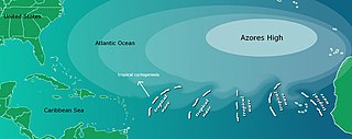
The Azores High also known as North Atlantic (Subtropical) High/Anticyclone or the Bermuda-Azores High, is a large subtropical semi-permanent centre of high atmospheric pressure typically found south of the Azores in the Atlantic Ocean, at the Horse latitudes. It forms one pole of the North Atlantic oscillation, the other being the Icelandic Low. The system influences the weather and climatic patterns of vast areas of North Africa, Western Asia, Southern Europe, and to a lesser extent, eastern North America. The aridity of the Sahara Desert and the summer drought of the Mediterranean Basin is due to the large-scale subsidence and sinking motion of air in the system. In its summer position, the high is centered near Bermuda, and creates a southwest flow of warm tropical air toward the East Coast of the United States. In summer, the Azores-Bermuda High is strongest. The central pressure hovers around 1024 mbar (hPa).

<span class="mw-page-title-main">Extratropical cyclone</span> Type of cyclone

Extratropical cyclones, sometimes called mid-latitude cyclones or wave cyclones, are low-pressure areas which, along with the anticyclones of high-pressure areas, drive the weather over much of the Earth. Extratropical cyclones are capable of producing anything from cloudiness and mild showers to severe gales, thunderstorms, blizzards, and tornadoes. These types of cyclones are defined as large scale (synoptic) low pressure weather systems that occur in the middle latitudes of the Earth. In contrast with tropical cyclones, extratropical cyclones produce rapid changes in temperature and dew point along broad lines, called weather fronts, about the center of the cyclone.

<span class="mw-page-title-main">Cold-air damming</span>

Cold air damming, or CAD, is a meteorological phenomenon that involves a high-pressure system (anticyclone) accelerating equatorward east of a north-south oriented mountain range due to the formation of a barrier jet behind a cold front associated with the poleward portion of a split upper level trough. Initially, a high-pressure system moves poleward of a north-south mountain range. Once it sloshes over poleward and eastward of the range, the flow around the high banks up against the mountains, forming a barrier jet which funnels cool air down a stretch of land east of the mountains. The higher the mountain chain, the deeper the cold air mass becomes lodged to its east, and the greater impediment it is within the flow pattern and the more resistant it becomes to intrusions of milder air.

<span class="mw-page-title-main">Cold front</span> Leading edge of a cooler mass of air

A cold front is the leading edge of a cooler mass of air at ground level that replaces a warmer mass of air and lies within a pronounced surface trough of low pressure. It often forms behind an extratropical cyclone, at the leading edge of its cold air advection pattern—known as the cyclone's dry "conveyor belt" flow. Temperature differences across the boundary can exceed 30 °C (54 °F) from one side to the other. When enough moisture is present, rain can occur along the boundary. If there is significant instability along the boundary, a narrow line of thunderstorms can form along the frontal zone. If instability is weak, a broad shield of rain can move in behind the front, and evaporative cooling of the rain can increase the temperature difference across the front. Cold fronts are stronger in the fall and spring transition seasons and are weakest during the summer.

<span class="mw-page-title-main">Papagayo Jet</span>

The Papagayo jet, also referred to as the Papagayo Wind or the Papagayo Wind Jet, are strong intermittent winds that blow approximately 70 km north of the Gulf of Papagayo, after which they are named. The jet winds travel southwest from the Caribbean and the Gulf of Mexico to the Pacific Ocean through a pass in the Cordillera mountains at Lake Nicaragua. The jet follows the same path as the northeast trade winds in this region; however, due to a unique combination of synoptic scale meteorology and orographic phenomena, the jet winds can reach much greater speeds than their trade wind counterparts. That is to say, the winds occur when cold high-pressure systems from the North American continent meet warm moist air over the Caribbean and Gulf of Mexico, generating winds that are then funneled through a mountain pass in the Cordillera. The Papagayo jet is also not unique to this region. There are two other breaks in the Cordillera where this same phenomenon occurs, one at the Chivela Pass in México and another at the Panama Canal, producing the Tehuano (Tehuantepecer) and the Panama jets respectively.

<span class="mw-page-title-main">Glossary of meteorology</span> List of definitions of terms and concepts commonly used in meteorology

This glossary of meteorology is a list of terms and concepts relevant to meteorology and atmospheric science, their sub-disciplines, and related fields.

References

  1. "An Australian "Anti-storm"". NASA. 8 June 2012. Retrieved 12 February 2013.
  2. "European Heat Wave". 16 August 2003.
  3. "A dry start to winter". boom.gov.au. Australian Government Bureau of Meteorology. July 2017. Archived from the original on 12 October 2022. Retrieved 19 October 2022.
  4. "Cyclone". Dictionary.com. Retrieved 24 January 2013.
  5. | "Word Origin & History" [http://dictionary.reference.com/browse/anticyclone]|accessed 24 January 2013
  6. Glossary of Meteorology (2009). Level of nondivergence. American Meteorological Society. Retrieved on 17 February 2009.
  7. Konstantin Matchev (2009). Middle-Latitude Cyclones – II. Archived 25 February 2009 at the Wayback Machine University of Florida. Retrieved on 16 February 2009.
  8. Keith C. Heidorn (2005). Weather's Highs and Lows: Part 1 The High. The Weather Doctor. Retrieved on 16 February 2009.
  9. Glossary of Meteorology (2009). High. American Meteorological Society. Retrieved on 16 February 2009.
  10. Office of the Federal Coordinator for Meteorology (2006). Appendix G: Glossary. Archived 25 February 2009 at the Wayback Machine NOAA. Retrieved on 16 February 2009.
  11. Jack Williams (2007). What's happening inside highs and lows. USA Today. Retrieved on 16 February 2009.
  12. Myanmar government (2007). Haze. Archived 27 January 2007 at the Wayback Machine Retrieved on 11 February 2007.
  13. Robert Tardif (2002). Fog characteristics. Archived 20 May 2011 at the Wayback Machine NCAR National Research Laboratory. Retrieved on 11 February 2007.
  14. CBC News (2009). Blame Yukon: Arctic air mass chills rest of North America. Canadian Broadcasting Centre. Retrieved on 16 February 2009.
  15. Federal Aviation Administration (1999). North Atlantic International General Aviation Operations Manual Chapter 2. Environment. FAA. Retrieved on 16 February 2009.
  16. Rasmussen, E.A. and Turner, J. (2003). Polar Lows: Mesoscale Weather Systems in the Polar Regions, Cambridge University Press, Cambridge, pp 612.
  17. Dr. Ali Tokay (2000). CHAPTER 11: Air Masses, Fronts, Cyclones, and Anticyclones. University of Maryland, Baltimore County. Retrieved on 16 February 2009.
  18. Anders Persson (2006). Hadley's Principle: Understanding and Misunderstanding the Trade Winds. Archived 25 June 2008 at the Wayback Machine International Commission on History of Meteorology: History of Meteorology 3. Retrieved on 16 February 2009.
  19. Becca Hatheway (2008). Hadley Cell. University Corporation for Atmospheric Research. Retrieved on 16 February 2009.
  20. Glossary of Meteorology (2009). Subtropical High. Archived 6 August 2007 at the Wayback Machine American Meteorological Society. Retrieved on 16 February 2009.
  21. 1 2 Climate Change Research Center (2002). STEC 521: Lesson 4 SURFACE PRESSURE SYSTEMS AND AIRMASSES. Archived 7 November 2009 at the Wayback Machine University of New Hampshire. Retrieved on 16 February 2009.
  22. ThinkQuest team 26634 (1999). The Formation of Deserts. Archived 17 October 2012 at the Wayback Machine Oracle ThinkQuest Education Foundation. Retrieved on 16 February 2009.
  23. W. T. Sturges (1991). Pollution of the Arctic Atmosphere. Springer, pp. 23. ISBN   978-1-85166-619-5. Retrieved on 16 February 2009.
  24. Glossary of Meteorology (2009). Siberian High. Archived 15 March 2012 at the Wayback Machine American Meteorological Society. Retrieved on 16 February 2009.
  25. Weather Online Limited (2009). Azores High. Retrieved on 16 February 2009.
  26. Chris Landsea (2009). "Frequently Asked Questions: What determines the movement of tropical cyclones?". Atlantic Oceanographic and Meteorological Laboratory . Retrieved 25 July 2006.
  27. Christopher C. Burt (2004). Extreme Weather (1 ed.). Twin Age Ltd. p.  234. ISBN   0-393-32658-6.
  28. BWEA (2007). Education and Careers: What is wind? Archived 4 March 2011 at the Wayback Machine British Wind Energy Association. Retrieved on 16 February 2009.
  29. JetStream (2008). Origin of Wind. National Weather Service Southern Region Headquarters. Retrieved on 16 February 2009.