The sky is everything that lies above the surface of the Earth, including the atmosphere and outer space.

Project Stormfury was an attempt to weaken tropical cyclones by flying aircraft into them and seeding with silver iodide. The project was run by the United States Government from 1962 to 1983. The hypothesis was that the silver iodide would cause supercooled water in the storm to freeze, disrupting the inner structure of the hurricane, and this led to seeding several Atlantic hurricanes. However, it was later shown that this hypothesis was incorrect. It was determined that most hurricanes do not contain enough supercooled water for cloud seeding to be effective. Additionally, researchers found that unseeded hurricanes often undergo the same structural changes that were expected from seeded hurricanes. This finding called Stormfury's successes into question, as the changes reported now had a natural explanation.
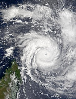
Typhoon Paka, known in the Philippines as Typhoon Rubing, was the last tropical cyclone of the 1997 Pacific hurricane and typhoon season, and was among the strongest Pacific typhoons in the month of December. Paka, which is the Hawaiian name for Pat, developed on November 28 from a trough well to the southwest of Hawaii. The storm tracked generally westward for much of its duration, and on December 7 it crossed into the western Pacific Ocean. Much of its track was characterized by fluctuations in intensity, and on December 10 the cyclone attained typhoon status as it crossed the Marshall Islands. On December 16, Paka struck Guam and Rota with winds of 230 km/h (145 mph), and it strengthened further to reach peak winds on December 18 over open waters as the final super typhoon of the year. Subsequently, it underwent a steady weakening trend, and on December 23 Paka dissipated.

This is a list of meteorology topics. The terms relate to meteorology, the interdisciplinary scientific study of the atmosphere that focuses on weather processes and forecasting.

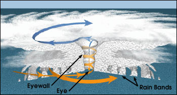
A rainband is a cloud and precipitation structure associated with an area of rainfall which is significantly elongated. Rainbands can be stratiform or convective, and are generated by differences in temperature. When noted on weather radar imagery, this precipitation elongation is referred to as banded structure. Rainbands within tropical cyclones are curved in orientation. Tropical cyclone rainbands contain showers and thunderstorms that, together with the eyewall and the eye, constitute a hurricane or tropical storm. The extent of rainbands around a tropical cyclone can help determine the cyclone's intensity.

An annular tropical cyclone is a tropical cyclone that features a normal to large, symmetric eye surrounded by a thick and uniform ring of intense convection, often having a relative lack of discrete rainbands, and bearing a symmetric appearance in general. As a result, the appearance of an annular tropical cyclone can be referred to as akin to a tire or doughnut. Annular characteristics can be attained as tropical cyclones intensify; however, outside the processes that drive the transition from asymmetric systems to annular systems and the abnormal resistance to negative environmental factors found in storms with annular features, annular tropical cyclones behave similarly to asymmetric storms. Most research related to annular tropical cyclones is limited to satellite imagery and aircraft reconnaissance as the conditions thought to give rise to annular characteristics normally occur over water well removed from landmasses where surface observations are possible.

The 1975 Pacific typhoon season was one of the deadliest tropical cyclone seasons on record, with nearly 230,000 fatalities occurring during the season. It had no official bounds; it ran year-round in 1975, but most tropical cyclones tend to form in the northwestern Pacific Ocean between June and December. These dates conventionally delimit the period of each year when most tropical cyclones form in the northwestern Pacific Ocean.

The eye is a region of mostly calm weather at the center of strong tropical cyclones. The eye of a storm is a roughly circular area, typically 30–65 kilometers in diameter. It is surrounded by the eyewall, a ring of towering thunderstorms where the most severe weather and highest winds occur. The cyclone's lowest barometric pressure occurs in the eye and can be as much as 15 percent lower than the pressure outside the storm.

The central dense overcast, or CDO, of a tropical cyclone or strong subtropical cyclone is the large central area of thunderstorms surrounding its circulation center, caused by the formation of its eyewall. It can be round, angular, oval, or irregular in shape. This feature shows up in tropical cyclones of tropical storm or hurricane strength. How far the center is embedded within the CDO, and the temperature difference between the cloud tops within the CDO and the cyclone's eye, can help determine a tropical cyclone's intensity. Locating the center within the CDO can be a problem for strong tropical storms and with systems of minimal hurricane strength as its location can be obscured by the CDO's high cloud canopy. This center location problem can be resolved through the use of microwave satellite imagery.
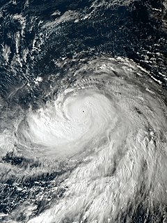
A tropical cyclone is a rapidly rotating storm system characterized by a low-pressure center, a closed low-level atmospheric circulation, strong winds, and a spiral arrangement of thunderstorms that produce heavy rain or squalls. Depending on its location and strength, a tropical cyclone is referred to by different names, including hurricane, typhoon, tropical storm, cyclonic storm, tropical depression, and simply cyclone. A hurricane is a tropical cyclone that occurs in the Atlantic Ocean and northeastern Pacific Ocean, and a typhoon occurs in the northwestern Pacific Ocean; in the south Pacific or Indian Ocean, comparable storms are referred to simply as "tropical cyclones" or "severe cyclonic storms".
Typhoon Sepat, known in the Philippines as Typhoon Egay, was the eighth named tropical storm, and the strongest tropical cyclone of the 2007 Pacific typhoon season to date, that affected the Philippines and made landfall in Taiwan and Fujian. The storm was formed on August 11 via a low-circulation center SE of Naha, Okinawa, and was named by JMA as Sepat on August 12, also known as Egay in the Philippines as it entered the PAR later. Sepat underwent an explosive intensification on the night of August 13, reaching peak intensity at Category 5 the following morning. The storm maintained its strength for 2 days until it underwent an eyewall replacement cycle, just before he storm makes landfall in Taiwan on August 17 as a Category 3-equivalent typhoon. After crossing the Taiwanese strait, Sepat; already weakening into Category 1 status due to unfavorable conditions, made a second landfall in China on August 18, 2007. The storm persisted across Mainland China, as it transitioned into an extratropical cyclone on August 20, and Sepat, now an extratropical low continued through the Chinese mainland until it finally dissipated near Yuunan Province on August 22.

Eyewall replacement cycles, also called concentric eyewall cycles, naturally occur in intense tropical cyclones, generally with winds greater than 185 km/h (115 mph), or major hurricanes. When tropical cyclones reach this intensity, and the eyewall contracts or is already sufficiently small, some of the outer rainbands may strengthen and organize into a ring of thunderstorms—an outer eyewall—that slowly moves inward and robs the inner eyewall of its needed moisture and angular momentum. Since the strongest winds are in a cyclone's eyewall, the tropical cyclone usually weakens during this phase, as the inner wall is "choked" by the outer wall. Eventually the outer eyewall replaces the inner one completely, and the storm may re-intensify.

The following is a glossary of tropical cyclone terms.

Typhoon Bilis, known in the Philippines as Typhoon Isang, was the strongest tropical cyclone in the western Pacific during 2000 and wrought considerable damage in Taiwan and China in August of that year. The tenth named storm of the season, Bilis originated from an area of disturbed weather that developed into a tropical depression southeast of Guam on August 18. Situated within an environment highly conductive for continued tropical development, the depression intensified into a tropical storm a day after formation; Bilis was upgraded to typhoon status on August 20 as it maintained a northwest course. Without significant inhibiting factors, the typhoon reached peak intensity with maximum sustained winds of 205 km/h (125 mph) and a minimum barometric pressure of 920 mbar. At the same intensity Bilis made landfall on Taiwan the following day. Despite its short stint over land, Bilis was greatly weakened, and made a brief track over the Taiwan Strait before its final landfall on China's Fujian Province early the next day. Moving inland into Mainland China, Bilis quickly weakened, and was only a tropical depression later that day; the depression diffused into a remnant low on August 25. These remnants tracked northeast across the Yellow Sea before dissipating in the Korean Peninsula on August 27.
Typhoon Fengshen was the strongest storm of the 2002 Pacific typhoon season. It developed on July 13 from the monsoon trough near the Marshall Islands, and quickly intensified due to its small size. By July 15, Fengshen attained typhoon status, and after initially moving to the north, it turned toward the northwest. On July 18, the typhoon reached its peak intensity of 185 km/h, according to the Japan Meteorological Agency. The Joint Typhoon Warning Center estimated peak winds of 270 km/h, and the agency estimated that Fengshen was a super typhoon for five days. This broke the record for longest duration at that intensity, previously set by Typhoon Joan in 1997, and which was later tied by Typhoon Ioke in 2006.
Very Intense Tropical Cyclone Hary was the strongest tropical cyclone in the 2001–02 South-West Indian Ocean cyclone season. Developing on March 5 from the monsoon trough, the storm initially moved generally to the west and gradually intensified. With favorable conditions, Hary quickly intensified on March 7, developing an eye and well-defined outflow. After reaching an initial peak, the cyclone briefly weakened due to an eyewall replacement cycle, by which time the storm turned southwestward toward Madagascar. Hary re-intensified and attained peak winds of 220 km/h (140 mph) on March 10 just offshore eastern Madagascar, which made it the first very intense tropical cyclone since 2000.

Typhoon Haiyan's meteorological history began with its origins as a tropical disturbance east-southeast of Pohnpei and lasted until its degeneration as a tropical cyclone over Southern China. The thirteenth typhoon of the 2013 Pacific typhoon season, Haiyan originated from an area of low pressure several hundred kilometers east-southeast of Pohnpei in the Federated States of Micronesia on November 2. Tracking generally westward, environmental conditions favored tropical cyclogenesis and the system developed into a tropical depression the following day. After becoming a tropical storm and attaining the name Haiyan at 0000 UTC on November 4, the system began a period of rapid intensification that brought it to typhoon intensity by 1800 UTC on November 5. By November 6, the Joint Typhoon Warning Center (JTWC) assessed the system as a Category 5-equivalent super typhoon on the Saffir-Simpson hurricane wind scale; the storm passed over the island of Kayangel in Palau shortly after attaining this strength.
This glossary of meteorology is a list of terms and concepts relevant to meteorology and atmospheric science, their sub-disciplines, and related fields.

Typhoon Wutip, known in the Philippines as Tropical Depression Betty, was the most powerful February typhoon on record, surpassing Typhoon Higos of 2015. The third tropical cyclone, second tropical storm, and the first typhoon of the 2019 Pacific typhoon season, Wutip originated from a low-pressure area on February 16, 2019. The disturbance moved westward, passing just south of the Federated States of Micronesia, before later organizing into Tropical Depression 02W on February 18, 2019. On February 20, 2019, the tropical depression intensified into a tropical storm and was named Wutip, before strengthening further into a typhoon on the next day. Wutip underwent rapid intensification, and on February 23, Wutip reached its peak intensity, with 10-minute sustained winds of 195 km/h (120 mph), 1-minute sustained winds of 270 km/h (165 mph), and a minimal pressure of 920 millibars (27 inHg) while passing to the southwest of Guam, becoming the strongest February typhoon on record as it did so.
Typhoon Hagibis, known in Japan as Reiwa 1 East Japan Typhoon, was an extremely violent and large tropical cyclone that caused widespread destruction across its path, starting from October 6, 2019, up until October 13, 2019. The 38th depression, 9th typhoon and 3rd super typhoon of the 2019 Pacific typhoon season, it was the strongest typhoon in decades to strike mainland Japan, and one of the largest typhoons ever recorded at a peak diameter of 825 nautical miles. Hagibis was also the deadliest typhoon to hit Japan since Typhoon Tip in 1979. Its death toll is marginally higher than that of Typhoon Bess in 1982 and Typhoon Tokage in 2004.